
10.1: Plate Tectonics and Continental Drift
- Page ID
- 21754
\( \newcommand{\vecs}[1]{\overset { \scriptstyle \rightharpoonup} {\mathbf{#1}} } \)
\( \newcommand{\vecd}[1]{\overset{-\!-\!\rightharpoonup}{\vphantom{a}\smash {#1}}} \)
\( \newcommand{\id}{\mathrm{id}}\) \( \newcommand{\Span}{\mathrm{span}}\)
( \newcommand{\kernel}{\mathrm{null}\,}\) \( \newcommand{\range}{\mathrm{range}\,}\)
\( \newcommand{\RealPart}{\mathrm{Re}}\) \( \newcommand{\ImaginaryPart}{\mathrm{Im}}\)
\( \newcommand{\Argument}{\mathrm{Arg}}\) \( \newcommand{\norm}[1]{\| #1 \|}\)
\( \newcommand{\inner}[2]{\langle #1, #2 \rangle}\)
\( \newcommand{\Span}{\mathrm{span}}\)
\( \newcommand{\id}{\mathrm{id}}\)
\( \newcommand{\Span}{\mathrm{span}}\)
\( \newcommand{\kernel}{\mathrm{null}\,}\)
\( \newcommand{\range}{\mathrm{range}\,}\)
\( \newcommand{\RealPart}{\mathrm{Re}}\)
\( \newcommand{\ImaginaryPart}{\mathrm{Im}}\)
\( \newcommand{\Argument}{\mathrm{Arg}}\)
\( \newcommand{\norm}[1]{\| #1 \|}\)
\( \newcommand{\inner}[2]{\langle #1, #2 \rangle}\)
\( \newcommand{\Span}{\mathrm{span}}\) \( \newcommand{\AA}{\unicode[.8,0]{x212B}}\)
\( \newcommand{\vectorA}[1]{\vec{#1}} % arrow\)
\( \newcommand{\vectorAt}[1]{\vec{\text{#1}}} % arrow\)
\( \newcommand{\vectorB}[1]{\overset { \scriptstyle \rightharpoonup} {\mathbf{#1}} } \)
\( \newcommand{\vectorC}[1]{\textbf{#1}} \)
\( \newcommand{\vectorD}[1]{\overrightarrow{#1}} \)
\( \newcommand{\vectorDt}[1]{\overrightarrow{\text{#1}}} \)
\( \newcommand{\vectE}[1]{\overset{-\!-\!\rightharpoonup}{\vphantom{a}\smash{\mathbf {#1}}}} \)
\( \newcommand{\vecs}[1]{\overset { \scriptstyle \rightharpoonup} {\mathbf{#1}} } \)
\( \newcommand{\vecd}[1]{\overset{-\!-\!\rightharpoonup}{\vphantom{a}\smash {#1}}} \)
Introduction
The surface of the lithosphere is fractured into a number of tectonic plates (also known as lithospheric or crustal plates) which are in constant motion. As these plates move and collide, the lithosphere buckles, warps, and is torn apart. When this occurs, the Earth's surface shakes with great force, like that which accompanies earthquakes. Volcanoes are common along many plate boundaries as well.
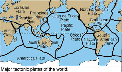
Plate Tectonics
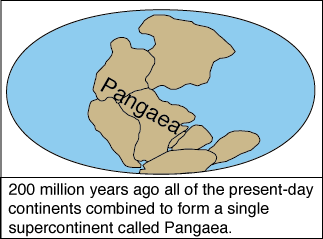
Plate tectonics refers to the process of plate formation, movement, and destruction. It finds its foundations in two theories, continental drift and sea-floor spreading. Continental drift describes the movements of continents over the Earth's surface. Sea-floor spreading refers to the creation of new oceanic plate material and movement away from the mid-ocean ridge. It was Alfred Wegener ![]() in the early 1900's who brought forth the concept that the "shell" of the Earth's surface was fractured, and these "pieces" drifted about. Blasphemy in the minds of scientists of Wegener's day, but some 50 years later his ideas were finally accepted. Wegener was able to piece together (pardon the pun) several bits of information which led to his conclusion that the present configuration of the continents is not the same as it was in the past. In fact, the continents were once one "super-continent" called Pangea.
in the early 1900's who brought forth the concept that the "shell" of the Earth's surface was fractured, and these "pieces" drifted about. Blasphemy in the minds of scientists of Wegener's day, but some 50 years later his ideas were finally accepted. Wegener was able to piece together (pardon the pun) several bits of information which led to his conclusion that the present configuration of the continents is not the same as it was in the past. In fact, the continents were once one "super-continent" called Pangea.
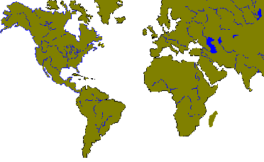
Look at a map of the Earth like that in Figure \(\PageIndex{3}\). Carefully examine the east coast of South America and then let your eyes drift to the west coast of Africa. It looks like you could "fit" South America up against Africa like a puzzle. The same can be said for the fit between North America, Africa, and Europe (Figure \(\PageIndex{4}\))
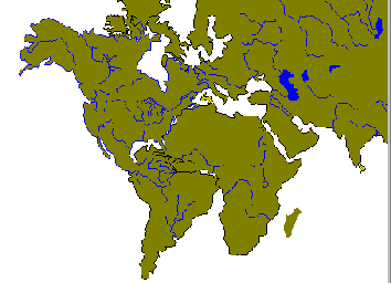
When we slide the continents together, some over lap between the land masses occurs. This is possibly due to the creation of exotic terrain, new land that has been formed somewhere else and moved to its present location. This remarkable correspondence provides circumstantial evidence for the theory of continental drift.
Looking for the evidence
If the continents were in one piece at some time in the past, we should find similar fossils and rocks on both continents which is precisely what Wegener discovered. By studying the geologic record, the fossil record, and climatic record, he found remarkable similarities between Africa and South America.
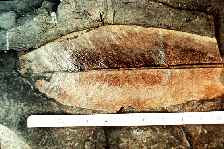
Fossils of the same species of plants and animals were found in similar geologic formations in different parts of the world, most notably South America, Africa, and India. For example, fossils of the Glossopteris, an ancient fern, are found in South America, Africa, Antarctica, India, and Australia. It was hypothesized that such a distribution could only come about if the continents were all part of the one super-continent.
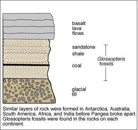
Examining the stratigraphy (vertical sequences) of the rock record, Wegener could point to further evidence for Pangea and continental drift. Wegener noted that the rock sequences in South America, Africa, India, and Australia are very similar. Wegener showed that the same three bottoms layers occurred on each of the continents. The bottom layer, called tillite, was thought to be of glacial origin. The middle layer composed of coal beds, shale and sandstone contained Glossopteris fossils, as did the bottom tillite layer. The top most and youngest layer is lava flows. Such a strong similarity in the rock record of these localities, now separated by great geographic distance, lent credence to Wegener's notion of continental drift.
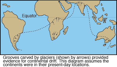
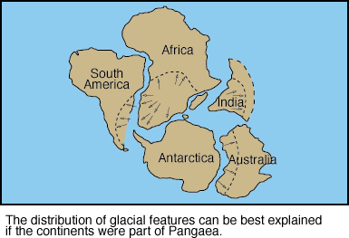
The occurrence of glacial features (Figure \(\PageIndex{7}\)) in the geologic record of South America, Africa, India ,and Australia provides further evidence for the notion of continental drift. Glaciers affected all or part of these continents at the same time in Earth history.
The Mobile Crust
Wegener's ideas were not readily accepted during his day because he did not offer a plausible mechanism for the movement of the continents. Wegener suggested it was the spin of the Earth that caused plates to "plow" their way through the mantle beneath.
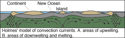
It wasn't until 1928 that a Scottish geologist proposed a mechanism to drive continental drift. Arthur Holmes ![]() believed a fluid mantle possessed convection currents created by heat trapped beneath the Earth's surface. Holmes hypothesized that convection currents welled up toward the surface and then dragged continents across the surface.
believed a fluid mantle possessed convection currents created by heat trapped beneath the Earth's surface. Holmes hypothesized that convection currents welled up toward the surface and then dragged continents across the surface.

In the late 1950's and early 1960's oceanographic research was opening the final frontier on Earth, the mysteries of the ocean floor. Known for over a century, the mid-ocean ridge system in the Atlantic Ocean rises some 6,500 feet above the surrounding ocean floor and extends for more that 37,500 miles (60,000 km) in all the world's oceans. At the crest of the ridge system lies a trough or rift. These rifts are about 20 miles wide (30 km) and 6,500 feet (2,900 m) deep and are a site where lava is expelled on to the ocean floor. The youngest material is found near the ridge with rocks of increasing age further away. It appears that the mid-ocean ridge is the site of sea floor spreading, leading to plate movement. The key to sea floor spreading was found in the magnetic properties of rock lying on the sea floor.
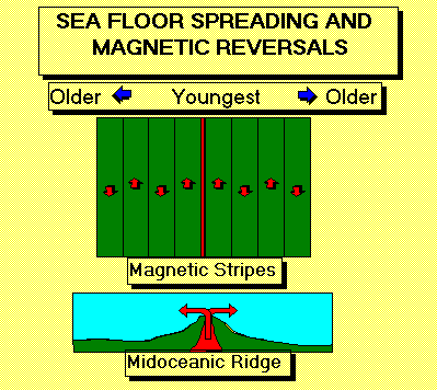
Geoscientists found that as new material is extruded from the mid-ocean ridge onto the ocean floor, the polarity of the rocks is frozen in time. Dragging a magnetometer across the ridge, they noticed that the polarity recorded a series of "flips" when the polarity of the rocks reversed. Parallel stripes of magnetic reversals on either side of the ridge was supporting evidence for sea floor spreading.
Modern Theory of Plate Movement and Continental Drift
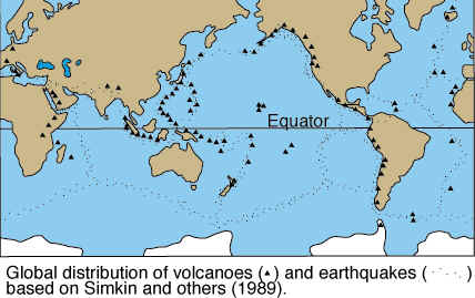
The movement of lithospheric plates referred to as continental drift, is believed to be caused by the radioactive decay of elements in the core and mantle that produces heat. The heat in turn creates convection currents in the mantle which "drive" the plates along their path of movement. When plates collide, heavier, more dense plates dive beneath lighter, less dense crustal plates along subduction zones. As the heavier plate moves downward into the mantle, the increase in temperature and pressure drive water and other volatile fluids ("dewatering") from the oceanic crust. At a depth of 100 kilometers (60 miles), the water-rich fluids decrease the melting point of mantle rock causing it to melt. This is magma that slowly moves upwards and may be extruded onto the surface as lava (Figure \(\PageIndex{13}\)). Some plates slip past one another, creating earthquakes, (Figure \(\PageIndex{13}\)) like what happens along the San Andreas fault in California. In many places the crust is separating and moving away in opposite directions, or diverging as happened to create the Great Rift Valley of Africa.

(Courtesy of USGS)
Though many earthquakes seemingly occur along plate boundaries, they can occur far away from the edges of plates too. One of the most well-known seismic regions is the New Madrid Seismic Zone located in the Mississippi Valley of the central United States, where four very large earthquakes occurred within three months in the winter of 1811-1812.