
6.4: Wave Cyclones (Cyclogenesis)
- Page ID
- 21701
The variable nature of weather in the midlatitudes is in part due to the presence of midlatitude or extratropical cyclones. Appropriately called "wave cyclones", these systems take the form of an ocean wave when fully developed. Wave cyclones can grow to vast proportions, nearly 1000 miles (1600 km) wide. These vast areas of low pressure are born along the polar front where cold polar air from the north collides with warm tropical air to the south. In so doing, huge spiraling storms move across the surface guided by the polar front jet stream.
Mature Stage
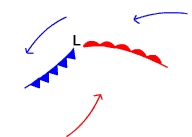
Once the air collides and cyclonic circulation commences, warm air from the south invades where cold air was once located north of the polar front (Figure \(\PageIndex{1}\)). A warm front develops where warm air replaces the cold air. The position of a warm front on a weather map is depicted (in red) with a line showing the boundary between the air masses and semi-circles indicating the direction the front is moving. To the west of the center of the developing system, cold air is sliding south replacing warm air at the surface. A cold front (blue triangles) develops where cold air replaces the warm air. Soon the developing system takes on the characteristic wave form, hence their name "wave cyclone". The lowest pressure is found at the center or apex of the wave.
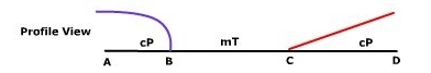
Figure \(\PageIndex{2}\) depicts the profile view of the open wave along a cross section just to the south of the system center. The less dense warmer air slides up and over the colder more dense air. Surface friction imposed by the ground slows the advance of the front compared to its position aloft yielding a gentle slope to the front.
Occluded Stage
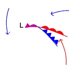
Because it is denser, cold air behind the cold front can "bulldoze" the warmer and less dense air out of the way. The advancing warm air along the warm front cannot push the colder air in its path out of the way. Instead, the warm air rises off the surface and glides up and over the colder more dense air ahead of the warm front. As a result, there is less horizontal displacement and the warm front moves slower across the earth than does a cold front. Over time the cold front catches up with the warm front and the cyclone starts to occlude (purple symbol on Figure \(\PageIndex{3}\)).
Dissolving Stage
The system enters the dissolving stage after it occludes and the lifting mechanism is cutoff. Without the convergence and uplift, the cyclone dissipates in the atmosphere.