
17.7: El Niño and La Niña
- Page ID
- 32281

\( \newcommand{\vecs}[1]{\overset { \scriptstyle \rightharpoonup} {\mathbf{#1}} } \)
\( \newcommand{\vecd}[1]{\overset{-\!-\!\rightharpoonup}{\vphantom{a}\smash {#1}}} \)
\( \newcommand{\id}{\mathrm{id}}\) \( \newcommand{\Span}{\mathrm{span}}\)
( \newcommand{\kernel}{\mathrm{null}\,}\) \( \newcommand{\range}{\mathrm{range}\,}\)
\( \newcommand{\RealPart}{\mathrm{Re}}\) \( \newcommand{\ImaginaryPart}{\mathrm{Im}}\)
\( \newcommand{\Argument}{\mathrm{Arg}}\) \( \newcommand{\norm}[1]{\| #1 \|}\)
\( \newcommand{\inner}[2]{\langle #1, #2 \rangle}\)
\( \newcommand{\Span}{\mathrm{span}}\)
\( \newcommand{\id}{\mathrm{id}}\)
\( \newcommand{\Span}{\mathrm{span}}\)
\( \newcommand{\kernel}{\mathrm{null}\,}\)
\( \newcommand{\range}{\mathrm{range}\,}\)
\( \newcommand{\RealPart}{\mathrm{Re}}\)
\( \newcommand{\ImaginaryPart}{\mathrm{Im}}\)
\( \newcommand{\Argument}{\mathrm{Arg}}\)
\( \newcommand{\norm}[1]{\| #1 \|}\)
\( \newcommand{\inner}[2]{\langle #1, #2 \rangle}\)
\( \newcommand{\Span}{\mathrm{span}}\) \( \newcommand{\AA}{\unicode[.8,0]{x212B}}\)
\( \newcommand{\vectorA}[1]{\vec{#1}} % arrow\)
\( \newcommand{\vectorAt}[1]{\vec{\text{#1}}} % arrow\)
\( \newcommand{\vectorB}[1]{\overset { \scriptstyle \rightharpoonup} {\mathbf{#1}} } \)
\( \newcommand{\vectorC}[1]{\textbf{#1}} \)
\( \newcommand{\vectorD}[1]{\overrightarrow{#1}} \)
\( \newcommand{\vectorDt}[1]{\overrightarrow{\text{#1}}} \)
\( \newcommand{\vectE}[1]{\overset{-\!-\!\rightharpoonup}{\vphantom{a}\smash{\mathbf {#1}}}} \)
\( \newcommand{\vecs}[1]{\overset { \scriptstyle \rightharpoonup} {\mathbf{#1}} } \)
\( \newcommand{\vecd}[1]{\overset{-\!-\!\rightharpoonup}{\vphantom{a}\smash {#1}}} \)
\(\newcommand{\avec}{\mathbf a}\) \(\newcommand{\bvec}{\mathbf b}\) \(\newcommand{\cvec}{\mathbf c}\) \(\newcommand{\dvec}{\mathbf d}\) \(\newcommand{\dtil}{\widetilde{\mathbf d}}\) \(\newcommand{\evec}{\mathbf e}\) \(\newcommand{\fvec}{\mathbf f}\) \(\newcommand{\nvec}{\mathbf n}\) \(\newcommand{\pvec}{\mathbf p}\) \(\newcommand{\qvec}{\mathbf q}\) \(\newcommand{\svec}{\mathbf s}\) \(\newcommand{\tvec}{\mathbf t}\) \(\newcommand{\uvec}{\mathbf u}\) \(\newcommand{\vvec}{\mathbf v}\) \(\newcommand{\wvec}{\mathbf w}\) \(\newcommand{\xvec}{\mathbf x}\) \(\newcommand{\yvec}{\mathbf y}\) \(\newcommand{\zvec}{\mathbf z}\) \(\newcommand{\rvec}{\mathbf r}\) \(\newcommand{\mvec}{\mathbf m}\) \(\newcommand{\zerovec}{\mathbf 0}\) \(\newcommand{\onevec}{\mathbf 1}\) \(\newcommand{\real}{\mathbb R}\) \(\newcommand{\twovec}[2]{\left[\begin{array}{r}#1 \\ #2 \end{array}\right]}\) \(\newcommand{\ctwovec}[2]{\left[\begin{array}{c}#1 \\ #2 \end{array}\right]}\) \(\newcommand{\threevec}[3]{\left[\begin{array}{r}#1 \\ #2 \\ #3 \end{array}\right]}\) \(\newcommand{\cthreevec}[3]{\left[\begin{array}{c}#1 \\ #2 \\ #3 \end{array}\right]}\) \(\newcommand{\fourvec}[4]{\left[\begin{array}{r}#1 \\ #2 \\ #3 \\ #4 \end{array}\right]}\) \(\newcommand{\cfourvec}[4]{\left[\begin{array}{c}#1 \\ #2 \\ #3 \\ #4 \end{array}\right]}\) \(\newcommand{\fivevec}[5]{\left[\begin{array}{r}#1 \\ #2 \\ #3 \\ #4 \\ #5 \\ \end{array}\right]}\) \(\newcommand{\cfivevec}[5]{\left[\begin{array}{c}#1 \\ #2 \\ #3 \\ #4 \\ #5 \\ \end{array}\right]}\) \(\newcommand{\mattwo}[4]{\left[\begin{array}{rr}#1 \amp #2 \\ #3 \amp #4 \\ \end{array}\right]}\) \(\newcommand{\laspan}[1]{\text{Span}\{#1\}}\) \(\newcommand{\bcal}{\cal B}\) \(\newcommand{\ccal}{\cal C}\) \(\newcommand{\scal}{\cal S}\) \(\newcommand{\wcal}{\cal W}\) \(\newcommand{\ecal}{\cal E}\) \(\newcommand{\coords}[2]{\left\{#1\right\}_{#2}}\) \(\newcommand{\gray}[1]{\color{gray}{#1}}\) \(\newcommand{\lgray}[1]{\color{lightgray}{#1}}\) \(\newcommand{\rank}{\operatorname{rank}}\) \(\newcommand{\row}{\text{Row}}\) \(\newcommand{\col}{\text{Col}}\) \(\renewcommand{\row}{\text{Row}}\) \(\newcommand{\nul}{\text{Nul}}\) \(\newcommand{\var}{\text{Var}}\) \(\newcommand{\corr}{\text{corr}}\) \(\newcommand{\len}[1]{\left|#1\right|}\) \(\newcommand{\bbar}{\overline{\bvec}}\) \(\newcommand{\bhat}{\widehat{\bvec}}\) \(\newcommand{\bperp}{\bvec^\perp}\) \(\newcommand{\xhat}{\widehat{\xvec}}\) \(\newcommand{\vhat}{\widehat{\vvec}}\) \(\newcommand{\uhat}{\widehat{\uvec}}\) \(\newcommand{\what}{\widehat{\wvec}}\) \(\newcommand{\Sighat}{\widehat{\Sigma}}\) \(\newcommand{\lt}{<}\) \(\newcommand{\gt}{>}\) \(\newcommand{\amp}{&}\) \(\definecolor{fillinmathshade}{gray}{0.9}\)Weather versus Climate
People often confuse weather and climate; they are not identical. According to the American Meteorological Society (AMS), the weather is defined as the state of the atmosphere at some place and time, usually expressed in terms of temperature, air pressure, humidity, wind speed and direction, precipitation, and cloudiness. Meteorologists study the atmosphere, processes that cause weather, and the life cycle of weather systems.
Climate is defined in terms of the average of weather elements (such as temperature and precipitation) over a specified period of time. (The World Meteorological Organization defines the typical time period of time as 30 years). The planet’s climate has changed many times over Earth’s long geologic history. For example, over the past million years, Earth has experienced several glacial periods interspersed with interglacial (warmer) periods. The relatively constant and favorable interglacial period of climate experienced over the past 8000 years has made human civilization’s advancement possible.
Climate also encompasses weather extremes for a particular place. Climate patterns are long-term atmospheric conditions that influence life on Earth. One important example of a climate pattern is the El Niño-Southern Oscillation. This cyclic climate pattern greatly affects the weather in Southern California as well as the rest of North America.
El Niño-Southern Oscillation
Upwelling of the coastal water off of Peru makes that region one of the world’s most productive fishing grounds. But every so often, the conditions in the region are very different. Every few years, the cold, nutrient-rich water is replaced by unusually warm water that is low in nutrients, leading to a decline in fish populations. In addition, the normally dry areas receive lots of rain. Because this phenomenon occurs in the northern winter close to Christmas, it is called El Niño (the child). More formally, the event is referred to as El Niño-Southern Oscillation (ENSO). The Southern Oscillation portion refers to the fluctuating atmospheric conditions that lead to the localized ocean warming of El Niño. While the exact reasons for the oscillation events are unclear, it is easier to understand how they lead to an El Niño.
Under normal conditions in the equatorial Pacific, the trade winds blow towards the west, moving large amounts of warm surface water towards the western Pacific around Southeast Asia. As the surface water moves west, it is replaced by cold, nutrient-rich deep water through upwelling. The coastal upwelling leads to a shallow thermocline in the eastern Pacific. In terms of atmospheric conditions, the trade winds are part of a convection cell called the Walker Cell. There is low pressure over the western Pacific, leading to rising moist air and significant precipitation in the region. In the eastern Pacific near South America, there is high pressure, leading to drier conditions.

El Niño
During an El Niño-Southern Oscillation, the high pressure system over the eastern Pacific diminishes, so the trade winds are weakened, or in extreme cases will even reverse. When this happens, warm surface water begins to flow east across the Pacific towards South America, warming the coastal South American water by up to 8°C in strong ENSO years. This influx of low-density warm water deepens the thermocline and prevents upwelling, which dramatically reduces productivity and can devastate populations of fish and other marine life.

In the atmosphere, the low pressure system in the western Pacific is replaced by high pressure, bringing dry or even drought conditions to Southeast Asia and Australia. The low pressure system moves east across the Pacific, potentially reaching as far as South America in strong El Niño years. The low pressure over the eastern Pacific brings lots of rain and flooding to South America. But the effects of El Niño are not just limited to the Pacific; it can influence weather patterns throughout the globe.
La Niña
Because the Southern Oscillation is a cyclic pattern, the eastern Pacific is not subject just to unusually warm conditions. There are also periods of abnormally cold water in the region known as La Niña events. During La Niña, the trade winds are unusually strong, leading to increased upwelling and transport of deep, cold water to the surface. The effects of La Niña are essentially the opposite of El Niño, bringing cooler and wetter conditions to the northwestern United States and Canada, while the southeastern U.S. receives below-average precipitation. Monsoon seasons in Asia are drier during El Niños but wetter during La Niña events.

El Niño and La Niña events alternate, although the presence of one does not always mean the other will automatically follow. El Niño occurs roughly every 2-7 years, and each event may last from a few months to a year or more. Although we do not understand exactly why or when the ENSO events will occur, we can anticipate their arrival by monitoring a number of ocean and atmospheric phenomena that make up the Multivariate ENSO Index (MEI). Examination of the MEI over time demonstrates the cyclic nature of ENSO events.
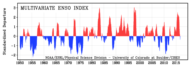
Figure \(\PageIndex{5}\) shows a comparison of sea surface temperatures in the equatorial Pacific during El Niño and La Niña periods.

Impacts of El Niño
ENSO events affect global atmospheric circulation such as the Polar and Pacific jet streams. This affects temperatures and precipitation worldwide. During El Niño in North America, the Pacific jet stream moves south from its normal position. This results in warmer, drier conditions than usual in the north, and wetter and colder conditions than usual in the south. During La Niña in North America, the Polar jet stream moves north from its normal position. The opposite conditions occur with colder and wetter conditions in the north, and drier and warmer conditions in the south.

The 2014-2016 El Niño was one of the strongest ENSO events on record (Figure \(\PageIndex{4}\)). Some of the recorded global impacts of this El Niño included:
- Widespread droughts in the Philippines and many South Pacific island nations.
- Severe coral bleaching on the Great Barrier Reef in Australia.
- One of the most destructive bushfire seasons in Australia, in part due to low rainfall.
- High rainfall in the southeastern United States and parts of California, leading to flooding.
- Mild, low-precipitation winter in the New England region of the United States.
- Severe flooding in Peru and Argentina.
- Droughts in many portions of southern Africa.
- Nearly 100 million people worldwide suffered a lack of food or water from flooding and droughts.
- Peru suspended its second anchovy fishing season due to low biomass, and an anticipated 20% reduction in the yearly catch.
Although many of the impacts are negative, there are some positive impacts such as lower heating bills for those areas that experience warmer than usual conditions in the winter. Also, a change in ocean temperatures near the coast can attract fish species that are not normally found in the area. Warmer waters can bring tropical fish such as yellowtail and albacore tuna, and colder waters can bring cold-water fish such as squid and salmon.
Additional links for more information
- What are the current ENSO conditions?: https://www.cpc.ncep.noaa.gov/products/precip/CWlink/MJO/enso.shtml