14.4: Glacial Landforms
- Page ID
- 32257

\( \newcommand{\vecs}[1]{\overset { \scriptstyle \rightharpoonup} {\mathbf{#1}} } \)
\( \newcommand{\vecd}[1]{\overset{-\!-\!\rightharpoonup}{\vphantom{a}\smash {#1}}} \)
\( \newcommand{\dsum}{\displaystyle\sum\limits} \)
\( \newcommand{\dint}{\displaystyle\int\limits} \)
\( \newcommand{\dlim}{\displaystyle\lim\limits} \)
\( \newcommand{\id}{\mathrm{id}}\) \( \newcommand{\Span}{\mathrm{span}}\)
( \newcommand{\kernel}{\mathrm{null}\,}\) \( \newcommand{\range}{\mathrm{range}\,}\)
\( \newcommand{\RealPart}{\mathrm{Re}}\) \( \newcommand{\ImaginaryPart}{\mathrm{Im}}\)
\( \newcommand{\Argument}{\mathrm{Arg}}\) \( \newcommand{\norm}[1]{\| #1 \|}\)
\( \newcommand{\inner}[2]{\langle #1, #2 \rangle}\)
\( \newcommand{\Span}{\mathrm{span}}\)
\( \newcommand{\id}{\mathrm{id}}\)
\( \newcommand{\Span}{\mathrm{span}}\)
\( \newcommand{\kernel}{\mathrm{null}\,}\)
\( \newcommand{\range}{\mathrm{range}\,}\)
\( \newcommand{\RealPart}{\mathrm{Re}}\)
\( \newcommand{\ImaginaryPart}{\mathrm{Im}}\)
\( \newcommand{\Argument}{\mathrm{Arg}}\)
\( \newcommand{\norm}[1]{\| #1 \|}\)
\( \newcommand{\inner}[2]{\langle #1, #2 \rangle}\)
\( \newcommand{\Span}{\mathrm{span}}\) \( \newcommand{\AA}{\unicode[.8,0]{x212B}}\)
\( \newcommand{\vectorA}[1]{\vec{#1}} % arrow\)
\( \newcommand{\vectorAt}[1]{\vec{\text{#1}}} % arrow\)
\( \newcommand{\vectorB}[1]{\overset { \scriptstyle \rightharpoonup} {\mathbf{#1}} } \)
\( \newcommand{\vectorC}[1]{\textbf{#1}} \)
\( \newcommand{\vectorD}[1]{\overrightarrow{#1}} \)
\( \newcommand{\vectorDt}[1]{\overrightarrow{\text{#1}}} \)
\( \newcommand{\vectE}[1]{\overset{-\!-\!\rightharpoonup}{\vphantom{a}\smash{\mathbf {#1}}}} \)
\( \newcommand{\vecs}[1]{\overset { \scriptstyle \rightharpoonup} {\mathbf{#1}} } \)
\(\newcommand{\longvect}{\overrightarrow}\)
\( \newcommand{\vecd}[1]{\overset{-\!-\!\rightharpoonup}{\vphantom{a}\smash {#1}}} \)
\(\newcommand{\avec}{\mathbf a}\) \(\newcommand{\bvec}{\mathbf b}\) \(\newcommand{\cvec}{\mathbf c}\) \(\newcommand{\dvec}{\mathbf d}\) \(\newcommand{\dtil}{\widetilde{\mathbf d}}\) \(\newcommand{\evec}{\mathbf e}\) \(\newcommand{\fvec}{\mathbf f}\) \(\newcommand{\nvec}{\mathbf n}\) \(\newcommand{\pvec}{\mathbf p}\) \(\newcommand{\qvec}{\mathbf q}\) \(\newcommand{\svec}{\mathbf s}\) \(\newcommand{\tvec}{\mathbf t}\) \(\newcommand{\uvec}{\mathbf u}\) \(\newcommand{\vvec}{\mathbf v}\) \(\newcommand{\wvec}{\mathbf w}\) \(\newcommand{\xvec}{\mathbf x}\) \(\newcommand{\yvec}{\mathbf y}\) \(\newcommand{\zvec}{\mathbf z}\) \(\newcommand{\rvec}{\mathbf r}\) \(\newcommand{\mvec}{\mathbf m}\) \(\newcommand{\zerovec}{\mathbf 0}\) \(\newcommand{\onevec}{\mathbf 1}\) \(\newcommand{\real}{\mathbb R}\) \(\newcommand{\twovec}[2]{\left[\begin{array}{r}#1 \\ #2 \end{array}\right]}\) \(\newcommand{\ctwovec}[2]{\left[\begin{array}{c}#1 \\ #2 \end{array}\right]}\) \(\newcommand{\threevec}[3]{\left[\begin{array}{r}#1 \\ #2 \\ #3 \end{array}\right]}\) \(\newcommand{\cthreevec}[3]{\left[\begin{array}{c}#1 \\ #2 \\ #3 \end{array}\right]}\) \(\newcommand{\fourvec}[4]{\left[\begin{array}{r}#1 \\ #2 \\ #3 \\ #4 \end{array}\right]}\) \(\newcommand{\cfourvec}[4]{\left[\begin{array}{c}#1 \\ #2 \\ #3 \\ #4 \end{array}\right]}\) \(\newcommand{\fivevec}[5]{\left[\begin{array}{r}#1 \\ #2 \\ #3 \\ #4 \\ #5 \\ \end{array}\right]}\) \(\newcommand{\cfivevec}[5]{\left[\begin{array}{c}#1 \\ #2 \\ #3 \\ #4 \\ #5 \\ \end{array}\right]}\) \(\newcommand{\mattwo}[4]{\left[\begin{array}{rr}#1 \amp #2 \\ #3 \amp #4 \\ \end{array}\right]}\) \(\newcommand{\laspan}[1]{\text{Span}\{#1\}}\) \(\newcommand{\bcal}{\cal B}\) \(\newcommand{\ccal}{\cal C}\) \(\newcommand{\scal}{\cal S}\) \(\newcommand{\wcal}{\cal W}\) \(\newcommand{\ecal}{\cal E}\) \(\newcommand{\coords}[2]{\left\{#1\right\}_{#2}}\) \(\newcommand{\gray}[1]{\color{gray}{#1}}\) \(\newcommand{\lgray}[1]{\color{lightgray}{#1}}\) \(\newcommand{\rank}{\operatorname{rank}}\) \(\newcommand{\row}{\text{Row}}\) \(\newcommand{\col}{\text{Col}}\) \(\renewcommand{\row}{\text{Row}}\) \(\newcommand{\nul}{\text{Nul}}\) \(\newcommand{\var}{\text{Var}}\) \(\newcommand{\corr}{\text{corr}}\) \(\newcommand{\len}[1]{\left|#1\right|}\) \(\newcommand{\bbar}{\overline{\bvec}}\) \(\newcommand{\bhat}{\widehat{\bvec}}\) \(\newcommand{\bperp}{\bvec^\perp}\) \(\newcommand{\xhat}{\widehat{\xvec}}\) \(\newcommand{\vhat}{\widehat{\vvec}}\) \(\newcommand{\uhat}{\widehat{\uvec}}\) \(\newcommand{\what}{\widehat{\wvec}}\) \(\newcommand{\Sighat}{\widehat{\Sigma}}\) \(\newcommand{\lt}{<}\) \(\newcommand{\gt}{>}\) \(\newcommand{\amp}{&}\) \(\definecolor{fillinmathshade}{gray}{0.9}\)Both alpine and continental glaciers create two categories of landforms: erosional and depositional. Erosional landforms are formed by the removal of material. Depositional landforms are formed by the addition of material. Because glaciers were first studied by 18th and 19th century geologists in Europe, the terminology applied to glaciers and glacial features contains many terms derived from European languages.
Erosional Glacial Landforms
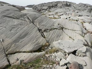
Erosional landforms are created when moving masses of glacial ice slide and grind over bedrock. Glacial ice contains large amounts of poorly sorted sand, gravel, and boulders that have been plucked and pried from the bedrock. As the glaciers slide across the bedrock, they grind these sediments into a fine powder called rock flour. Rock flour acts as fine grit that polishes the surface of the bedrock to a smooth finish called glacial polish. Larger rock fragments scrape over the surface creating elongated grooves called glacial striations.

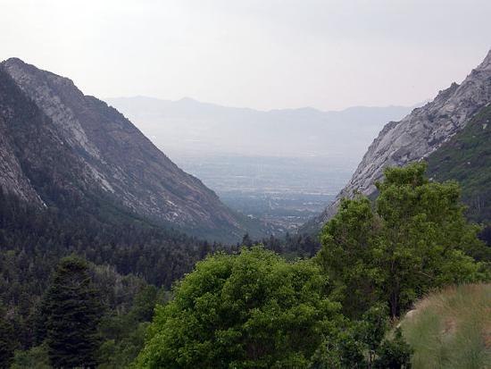
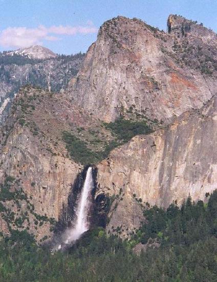
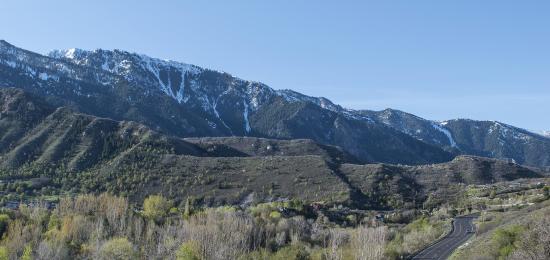
Alpine glaciers produce a variety of unique erosional landforms, such as U-shaped valleys, arêtes, cirques, tarns, horns, cols, hanging valleys, and truncated spurs. In contrast, stream-carved canyons have a V-shaped profile when viewed in cross-section. Glacial erosion transforms a former V-shaped stream valley into a U-shaped valley. Glaciers are typically wider than streams of similar length, and since glaciers tend to erode both at their bases and their sides, they erode V-shaped valleys into relatively flat-bottomed broad valleys with steep sides and a distinctive “U” shape [5]. As seen in the images, Little Cottonwood Canyon near Salt Lake City, Utah was occupied by an Ice Age glacier that extended down to the mouth of the canyon and into Lake Bonneville [10]. Today, that U-shaped valley hosts many erosional landforms, including polished and striated rock surfaces. In contrast, Big Cottonwood Canyon to the north of Little Cottonwood Canyon has retained the V-shape in its lower portion, indicating that its glacier did not extend clear to its mouth, but was confined to its upper portion.

 [CC BY-SA 4.0], via Wikimedia Commons")
When glaciers carve two U-shaped valleys adjacent to each other, the ridge between them tends to be sharpened into a sawtooth feature called an arête. At the head of a glacially carved valley is a bowl-shaped feature called a cirque. The cirque represents where the head of the glacier eroded the mountain by plucking rock away from it and the weight of the thick ice eroded out a bowl. After the glacier is gone, the bowl at the bottom of the cirque often fills with precipitation and is occupied by a lake, called a tarn. When three or more mountain glaciers erode headward at their cirques, they produce horns, steep-sided, spire-shaped mountains. Low points along arêtes or between horns are mountain passes termed cols. Where a smaller tributary glacier flows into a larger trunk glacier, the smaller glacier cuts down less. Once the ice has gone, the tributary valley is left as a hanging valley, sometimes with a waterfall plunging into the main valley. As the trunk glacier straightens and widens a V-shaped valley and erodes the ends of side ridges, a steep triangle-shaped cliff is formed called a truncated spur.

Depositional Glacial Landforms
Depositional landforms and materials are produced from deposits left behind by a retreating glacier. All glacial deposits are called drift. These include till, tillites, diamictites, terminal moraines, recessional moraines, lateral moraines, medial moraines, ground moraines, silt, outwash plains, glacial erratics, kettles, kettle lakes, crevasses, eskers, kames, and drumlins.
Glacial ice carries a lot of sediment, which when deposited by a melting glacier is called till. Till is poorly sorted with grain sizes ranging from clay and silt to pebbles and boulders. These clasts may be striated. Many depositional landforms are composed of till. The term tillite refers to lithified rock having glacial origins. Diamictite refers to a lithified rock that contains a wide range of clast sizes; this includes glacial till but is a more objective and descriptive term for any rock with a wide range of clast sizes.

Moraines are mounded deposits consisting of glacial till carried in the glacial ice and rock fragments dislodged by mass wasting from the U-shaped valley walls. The glacier acts like a conveyor belt, carrying and depositing sediment at the end of and along the sides of the ice flow. Because the ice in the glacier is always flowing downslope, all glaciers have moraines build up at their terminus, even those not advancing.
Moraines are classified by their location with respect to the glacier. A terminal moraine is a ridge of till located at the end or terminus of the glacier [11]. Recessional moraines are left as glaciers retreat and there are pauses in the retreat. Lateral moraines accumulate along the sides of the glacier from material mass wasted from the valley walls. When two tributary glaciers merge, the two lateral moraines combine to form a medial moraine running down the center of the combined glacier. Ground moraine is a veneer of till left on the land as the glacier melts.

In addition to moraines, glaciers leave behind other depositional landforms. Silt, sand, and gravel produced by the intense grinding process are carried by streams of water and deposited in front of the glacier in an area called the outwash plain. Retreating glaciers may leave behind large boulders that don’t match the local bedrock. These are called glacial erratics. When continental glaciers retreat, they can leave behind large blocks of ice within the till. These ice blocks melt and create a depression in the till called a kettle. If the depression later fills with water, it is called a kettle lake.
If meltwater flowing over the ice surface descends into crevasses in the ice, it may find a channel and continue to flow in sinuous channels within or at the base of the glacier. Within or under continental glaciers, these streams carry sediments. When the ice recedes, the accumulated sediment is deposited as a long sinuous ridge known as an esker. Meltwater descending down through the ice or over the margins of the ice may deposit mounds of till in hills called kames.
Drumlins are common in continental glacial areas of Germany, New York, and Wisconsin, where they typically are found in fields with great numbers. A drumlin is an elongated asymmetrical teardrop-shaped hill reflecting ice movement with its steepest side pointing upstream to the flow of ice and its streamlined or low-angled side pointing downstream in the direction of ice movement.
Glacial scientists debate the origins of drumlins. A leading idea is that drumlins are created from accumulated till being compressed and sculpted under a glacier that retreated then advanced again over its own ground moraine. Another idea is that meltwater catastrophically flooded under the glacier and carved the till into these streamlined mounds. Still another proposes that the weight of the overlying ice statically deformed the underlying till [12; 13].
Check your understanding of glacial landforms:
Glacial Lakes
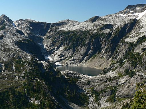
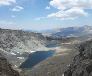
Glacial lakes are commonly found in alpine environments. A lake confined within a glacial cirque is called a tarn. A tarn forms when the depression in the cirque fills with precipitation after the ice is gone. Examples of tarns include Silver Lake near Brighton Ski resort in Big Cottonwood Canyon, Utah and Avalanche Lake in Glacier National Park, Montana.
 [<a data-cke-saved-href=\"http://creativecommons.org/licenses/by-sa/4.0\" href=\"http://creativecommons.org/licenses/by-sa/4.0 CC BY-SA 4.0], via Wikimedia Commons")
When recessional moraines create a series of isolated basins within a glaciated valley, the resulting chain of lakes is called paternoster lakes.
Lakes filled by glacial meltwater often look milky due to finely ground material called rock flour suspended in the water. Lakes that occupy long glacially carved depressions are known as finger lakes [5].

Proglacial lakes form along the edges of all the largest continental ice sheets, such as Antarctica and Greenland. The crust is depressed isostatically by the overlying ice sheet and these basins fill with glacial meltwater. Many such lakes, some of them huge, existed at various times along the southern edge of the Laurentide Ice Sheet during the last ice age. Lake Agassiz, Manitoba, Canada, is a classic example of a proglacial lake. Lake Winnipeg serves as the remnant of a much larger proglacial lake.

Other proglacial lakes were formed when glaciers dammed rivers and flooded the river valley. A classic example is Lake Missoula, which formed when a lobe of the Laurentide Ice Sheet blocked the Clark Fork River about 18,000 years ago. Over about 2000 years the ice dam holding back Lake Missoula failed several times. During each breach, the lake emptied across parts of eastern Washington, Oregon, and Idaho into the Columbia River Valley and eventually the Pacific Ocean. After each breach, the dam reformed and the lake refilled. Each breach produced a catastrophic flood over a few days. Scientists estimate that this cycle of ice dam, proglacial lake, and torrential massive flooding happened at least 25 times over a span of 20 centuries. The rate of each outflow is believed to have equaled the combined discharge of all of Earth’s current rivers combined. The landscape produced by these massive floods is preserved in the Channeled Scablands of Idaho, Washington, and Oregon [5].

Pluvial lakes form in humid environments that experience low temperatures and high precipitation. During the last glaciation, most of the western United States’ climate was cooler and more humid than today. Under these low-evaporation conditions, many large lakes, called pluvial lakes, formed in the basins of the Basin and Range Province. Two of the largest were Lake Bonneville and Lake Lahontan. Lake Lahontan was in northwestern Nevada. The figure illustrates the tremendous size of Lake Bonneville, which occupied much of western Utah and into eastern Nevada. The lake level fluctuated greatly over the centuries leaving several pronounced old shorelines marked by wave-cut terraces. These old shorelines can be seen on mountain slopes throughout the western portion of Utah, including the Salt Lake Valley, indicating that the now heavily urbanized valley was once filled with hundreds of feet of water. Lake Bonneville’s level peaked around 18,000 years ago [14] when a breach occurred at Red Rock Pass in Idaho and water spilled into the Snake River. The flooding rapidly lowered the lake level and scoured the Idaho landscape across the Pocatello Valley, the Snake River Plain, and Twin Falls. The floodwaters ultimately flowed into the Columbia River across part of the scablands area at an incredible discharge rate of about 4,750 cu km/sec (1,140 cu mi/sec) [15]. For comparison, this discharge rate would drain the volume of Lake Michigan completely dry within a few days.

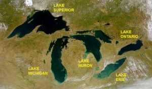
The five Great Lakes in North America’s upper Midwest are proglacial lakes that originated during the last ice age. The lake basins were originally carved by the encroaching continental ice sheet. The basins were later exposed as the ice retreated about 14,000 years ago and filled by precipitation.