
11.4: Glacial Landforms
- Page ID
- 28298

\( \newcommand{\vecs}[1]{\overset { \scriptstyle \rightharpoonup} {\mathbf{#1}} } \)
\( \newcommand{\vecd}[1]{\overset{-\!-\!\rightharpoonup}{\vphantom{a}\smash {#1}}} \)
\( \newcommand{\dsum}{\displaystyle\sum\limits} \)
\( \newcommand{\dint}{\displaystyle\int\limits} \)
\( \newcommand{\dlim}{\displaystyle\lim\limits} \)
\( \newcommand{\id}{\mathrm{id}}\) \( \newcommand{\Span}{\mathrm{span}}\)
( \newcommand{\kernel}{\mathrm{null}\,}\) \( \newcommand{\range}{\mathrm{range}\,}\)
\( \newcommand{\RealPart}{\mathrm{Re}}\) \( \newcommand{\ImaginaryPart}{\mathrm{Im}}\)
\( \newcommand{\Argument}{\mathrm{Arg}}\) \( \newcommand{\norm}[1]{\| #1 \|}\)
\( \newcommand{\inner}[2]{\langle #1, #2 \rangle}\)
\( \newcommand{\Span}{\mathrm{span}}\)
\( \newcommand{\id}{\mathrm{id}}\)
\( \newcommand{\Span}{\mathrm{span}}\)
\( \newcommand{\kernel}{\mathrm{null}\,}\)
\( \newcommand{\range}{\mathrm{range}\,}\)
\( \newcommand{\RealPart}{\mathrm{Re}}\)
\( \newcommand{\ImaginaryPart}{\mathrm{Im}}\)
\( \newcommand{\Argument}{\mathrm{Arg}}\)
\( \newcommand{\norm}[1]{\| #1 \|}\)
\( \newcommand{\inner}[2]{\langle #1, #2 \rangle}\)
\( \newcommand{\Span}{\mathrm{span}}\) \( \newcommand{\AA}{\unicode[.8,0]{x212B}}\)
\( \newcommand{\vectorA}[1]{\vec{#1}} % arrow\)
\( \newcommand{\vectorAt}[1]{\vec{\text{#1}}} % arrow\)
\( \newcommand{\vectorB}[1]{\overset { \scriptstyle \rightharpoonup} {\mathbf{#1}} } \)
\( \newcommand{\vectorC}[1]{\textbf{#1}} \)
\( \newcommand{\vectorD}[1]{\overrightarrow{#1}} \)
\( \newcommand{\vectorDt}[1]{\overrightarrow{\text{#1}}} \)
\( \newcommand{\vectE}[1]{\overset{-\!-\!\rightharpoonup}{\vphantom{a}\smash{\mathbf {#1}}}} \)
\( \newcommand{\vecs}[1]{\overset { \scriptstyle \rightharpoonup} {\mathbf{#1}} } \)
\(\newcommand{\longvect}{\overrightarrow}\)
\( \newcommand{\vecd}[1]{\overset{-\!-\!\rightharpoonup}{\vphantom{a}\smash {#1}}} \)
\(\newcommand{\avec}{\mathbf a}\) \(\newcommand{\bvec}{\mathbf b}\) \(\newcommand{\cvec}{\mathbf c}\) \(\newcommand{\dvec}{\mathbf d}\) \(\newcommand{\dtil}{\widetilde{\mathbf d}}\) \(\newcommand{\evec}{\mathbf e}\) \(\newcommand{\fvec}{\mathbf f}\) \(\newcommand{\nvec}{\mathbf n}\) \(\newcommand{\pvec}{\mathbf p}\) \(\newcommand{\qvec}{\mathbf q}\) \(\newcommand{\svec}{\mathbf s}\) \(\newcommand{\tvec}{\mathbf t}\) \(\newcommand{\uvec}{\mathbf u}\) \(\newcommand{\vvec}{\mathbf v}\) \(\newcommand{\wvec}{\mathbf w}\) \(\newcommand{\xvec}{\mathbf x}\) \(\newcommand{\yvec}{\mathbf y}\) \(\newcommand{\zvec}{\mathbf z}\) \(\newcommand{\rvec}{\mathbf r}\) \(\newcommand{\mvec}{\mathbf m}\) \(\newcommand{\zerovec}{\mathbf 0}\) \(\newcommand{\onevec}{\mathbf 1}\) \(\newcommand{\real}{\mathbb R}\) \(\newcommand{\twovec}[2]{\left[\begin{array}{r}#1 \\ #2 \end{array}\right]}\) \(\newcommand{\ctwovec}[2]{\left[\begin{array}{c}#1 \\ #2 \end{array}\right]}\) \(\newcommand{\threevec}[3]{\left[\begin{array}{r}#1 \\ #2 \\ #3 \end{array}\right]}\) \(\newcommand{\cthreevec}[3]{\left[\begin{array}{c}#1 \\ #2 \\ #3 \end{array}\right]}\) \(\newcommand{\fourvec}[4]{\left[\begin{array}{r}#1 \\ #2 \\ #3 \\ #4 \end{array}\right]}\) \(\newcommand{\cfourvec}[4]{\left[\begin{array}{c}#1 \\ #2 \\ #3 \\ #4 \end{array}\right]}\) \(\newcommand{\fivevec}[5]{\left[\begin{array}{r}#1 \\ #2 \\ #3 \\ #4 \\ #5 \\ \end{array}\right]}\) \(\newcommand{\cfivevec}[5]{\left[\begin{array}{c}#1 \\ #2 \\ #3 \\ #4 \\ #5 \\ \end{array}\right]}\) \(\newcommand{\mattwo}[4]{\left[\begin{array}{rr}#1 \amp #2 \\ #3 \amp #4 \\ \end{array}\right]}\) \(\newcommand{\laspan}[1]{\text{Span}\{#1\}}\) \(\newcommand{\bcal}{\cal B}\) \(\newcommand{\ccal}{\cal C}\) \(\newcommand{\scal}{\cal S}\) \(\newcommand{\wcal}{\cal W}\) \(\newcommand{\ecal}{\cal E}\) \(\newcommand{\coords}[2]{\left\{#1\right\}_{#2}}\) \(\newcommand{\gray}[1]{\color{gray}{#1}}\) \(\newcommand{\lgray}[1]{\color{lightgray}{#1}}\) \(\newcommand{\rank}{\operatorname{rank}}\) \(\newcommand{\row}{\text{Row}}\) \(\newcommand{\col}{\text{Col}}\) \(\renewcommand{\row}{\text{Row}}\) \(\newcommand{\nul}{\text{Nul}}\) \(\newcommand{\var}{\text{Var}}\) \(\newcommand{\corr}{\text{corr}}\) \(\newcommand{\len}[1]{\left|#1\right|}\) \(\newcommand{\bbar}{\overline{\bvec}}\) \(\newcommand{\bhat}{\widehat{\bvec}}\) \(\newcommand{\bperp}{\bvec^\perp}\) \(\newcommand{\xhat}{\widehat{\xvec}}\) \(\newcommand{\vhat}{\widehat{\vvec}}\) \(\newcommand{\uhat}{\widehat{\uvec}}\) \(\newcommand{\what}{\widehat{\wvec}}\) \(\newcommand{\Sighat}{\widehat{\Sigma}}\) \(\newcommand{\lt}{<}\) \(\newcommand{\gt}{>}\) \(\newcommand{\amp}{&}\) \(\definecolor{fillinmathshade}{gray}{0.9}\)Glacial landforms are of two kinds, erosional and depositional landforms. Erosional landforms are formed by removing material and consist of the material that remains. Depositional landforms are formed by the deposition of sediment.
Erosional Glacial Landforms
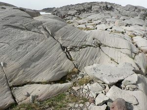
Both alpine and continental glaciers erode bedrock and create erosional landforms. Glaciers are heavy masses of abrasive ice that grind over the surface. Elongated grooves are created by fragments of rock embedded in the ice at the base of a glacier scraping along the bedrock surface called glacial striations. In addition, rock flour as fine grit in the ice can polish a hard granite or quartzite bedrock to a smooth surface called glacial polish. This figure illustrates these glacial landforms.

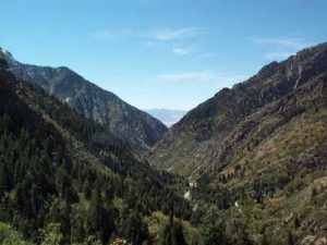
Following is a description of erosional landforms produced by alpine glaciers. Since glaciers are typically much wider than rivers of similar length, and since they tend to erode more at their bases than their sides, they transform former V-shaped stream valleys into broad valleys that have relatively flat bottoms and steep sides with a distinctive “U” shape [5]. In contrast, river-carved canyons have a V-shaped profile when viewed in cross-section.
 [Public domain], <a data-cke-saved-href=\"https://commons.wikimedia.org/wiki/File%3AUshapedValleyUT.JPG\" href=\"https://commons.wikimedia.org/wiki/File%3AUshapedValleyUT.JPG\"")
 [CC BY-SA 4.0], via Wikimedia Commons")
When two U-shaped valleys are adjacent to each other, the ridge between them can be carved into a sharp ridge called an arête. Since glaciers erode a broad valley, the arêtes are left behind with steep walls separating them. At the head of a glacially carved valley is a bowl-shaped feature called a cirque representing where the head of the glacier is eroding against the mountain by plucking rock away from it and the weight of the thick ice is eroding out a bowl. Headward cirque erosion by three or more mountain glaciers produces horns, which are steep-sided, spire-shaped mountains with pronounced cirques on three or more sides. When a smaller tributary glacier intersects a larger trunk glacier, the smaller glacier erodes down less. Therefore, once the ice has been removed, the tributary valley is left as a hanging valley, sometimes with a waterfall.
 [<a data-cke-saved-href=\"http://www.gnu.org/copyleft/fdl.html\" href=\"http://www.gnu.org/copyleft/fdl.html\"")

 [<a data-cke-saved-href=\"http://creativecommons.org/licenses/by-sa/1.0\" href=\"http://creativecommons.org/licenses/by-sa/1.0\"")
Depositional Glacial Landforms
 [Public domain], <a data-cke-saved-href=\"https://commons.wikimedia.org/wiki/File%3ADiamictite_Mineral_Fork.JPG\" href=\"https://commons.wikimedia.org/wiki/File%3ADiamictite_Mineral_Fork.JPG\"")
Sediment is deposited by glaciers in both alpine and continental environments. Since ice is responsible for a large amount of erosion, there is a lot of sediment in glacial ice. When sediment is left behind by a melting glacier, it is called till and is characteristically poorly sorted with grain sizes ranging from clay and silt to pebbles and boulders. Many of the depositional landforms described in this section are composed of till.
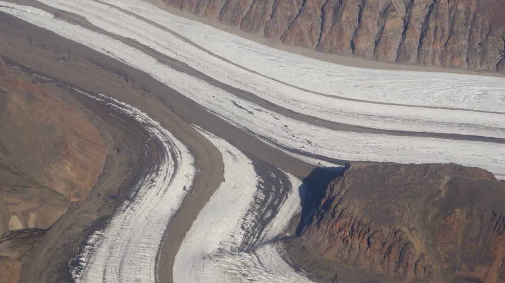
Material carried by the glacier is called moraine, which is an accumulation of glacial till produced by the grinding and erosive effects of a glacier. In valley glaciers, moraine also includes material falling on the sides of the glacier by mass wasting from the valley walls. The glacier acts like a conveyor belt, carrying sediment inside and on the ice and depositing it at the end and sides of the glacier. Because ice in the glacier is always flowing downslope, the deposited moraines build up even if the end of the glacier doesn’t advance. The type of moraine depends on its location. A terminal moraine is a ridge of unsorted till at the maximum extent of a glacier [11]. When glaciers retreat in episodes, they may leave behind deposits called recessional moraines. The recessional moraines look similar to terminal moraines but are formed when the glacier retreat pauses. Moraines located along the side of a glacier are called lateral moraines and mostly represent material that fell on the sides of the glacier from the mass wasting of the valley walls. When two tributary glaciers join together, the two lateral moraines combine to form a medial moraine. Behind the terminal and recessional moraines is a veneer (or thin sheet) of till on top of bedrock called ground moraine.

In addition to moraines, as glaciers melt they leave behind other depositional landforms. The intense grinding process creates a lot of silt. Streams of water melting from the glacier carry this silt (along with sand and gravel) and deposit it in front of the glacier in an area called an outwash plain. In addition, when glaciers retreat, they may leave behind large boulders of a type of rock that doesn’t match the local bedrock. These are called glacial erratics. When continental glaciers melt, large blocks of ice can be left behind to melt within the impermeable till and can create a depression called a kettle that can be later filled with surface water like a kettle lake.
Also common in continental glacial areas of New York state and Wisconsin are drumlins. A drumlin is an elongated asymmetrical drop-shaped hill with its steepest side pointing upstream to the flow of ice and streamlined side (low angle side) pointing in the direction the ice is flowing.
Drumlins can occur in great numbers in drumlin fields. The origin of drumlins is still debated and some leading ideas are the incremental accumulation of till under the glacier, large catastrophic meltwater floods located under the glacier, and surface deformation by the weight of the overlying glacial ice [12; 13].
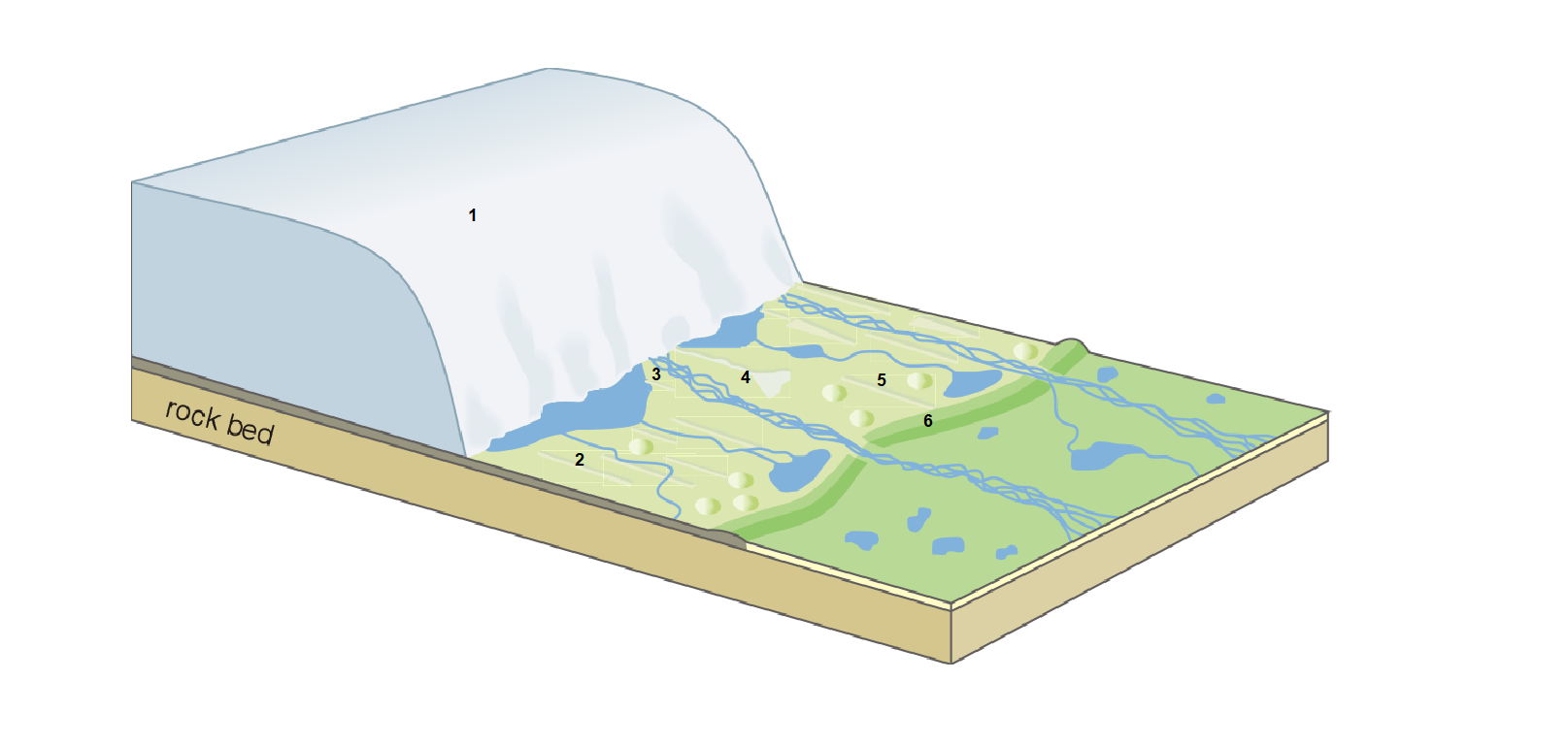
| Number | Name | Note |
|---|---|---|
| 1 | Receding Glacier | Sheet of ice with a terminus that is moving back with time. |
| 2 | Ground Morraine | N/A |
| 3 | Esker | N/A |
| 4 | Esker |  |
| 5 | Drumlin | N/A |
| 6 | Terminal Morraine |  |
Glacial Lakes
 [<a data-cke-saved-href=\"http://creativecommons.org/licenses/by-sa/4.0\" href=\"http://creativecommons.org/licenses/by-sa/4.0\"")
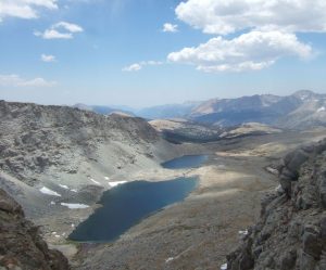
Lakes are common features in alpine glacial environments. A lake that is confined to a glacial cirque is known as a tarn such as Avalanche Lake in Glacier National Park. Tarns are common in areas of alpine glaciation because the thick ice that carves out a cirque also typically hollows out a depression in bedrock that after the glacier is gone, fills with precipitated water.
In some cases, recessional moraines may isolate a series of basins within a glaciated valley, and the resulting chain of lakes is called paternoster lakes.
During the last glaciation, most of the western United States had a cooler and wetter climate. Due to less evaporation and more precipitation, many large lakes formed in the basins of the Basin and Range Province called pluvial lakes. One of the largest pluvial lakes was Lake Bonneville. Lake Bonneville occupied much of western Utah and eastern Nevada (Figure from Miller et al 2013) and filled Salt Lake Valley, which is densely urbanized today, with water hundreds of feet deep. During the last glaciation, the level of the lake fluctuated many times leaving several pronounced old shorelines in the western portion of Utah including Salt Lake Valley identified by wave-cut terraces. Lake level peaked around 18,000 years ago [14] and spilled over Red Rock Pass in Idaho into the Snake River causing rapid erosion and a very large flood that rapidly lowered the lake level and scoured the land in Pocatello Valley, Snake River Plain, and Twin Falls Idaho. The flood ultimately flowed into the Columbia River across part of the scablands area and had an incredible discharge of about 4,750 km3 [15] which is about the volume of Lake Michigan. This would be as if one of the Great Lakes completely emptied within days.