
2.3: Convergent Boundaries
- Page ID
- 28217

\( \newcommand{\vecs}[1]{\overset { \scriptstyle \rightharpoonup} {\mathbf{#1}} } \)
\( \newcommand{\vecd}[1]{\overset{-\!-\!\rightharpoonup}{\vphantom{a}\smash {#1}}} \)
\( \newcommand{\id}{\mathrm{id}}\) \( \newcommand{\Span}{\mathrm{span}}\)
( \newcommand{\kernel}{\mathrm{null}\,}\) \( \newcommand{\range}{\mathrm{range}\,}\)
\( \newcommand{\RealPart}{\mathrm{Re}}\) \( \newcommand{\ImaginaryPart}{\mathrm{Im}}\)
\( \newcommand{\Argument}{\mathrm{Arg}}\) \( \newcommand{\norm}[1]{\| #1 \|}\)
\( \newcommand{\inner}[2]{\langle #1, #2 \rangle}\)
\( \newcommand{\Span}{\mathrm{span}}\)
\( \newcommand{\id}{\mathrm{id}}\)
\( \newcommand{\Span}{\mathrm{span}}\)
\( \newcommand{\kernel}{\mathrm{null}\,}\)
\( \newcommand{\range}{\mathrm{range}\,}\)
\( \newcommand{\RealPart}{\mathrm{Re}}\)
\( \newcommand{\ImaginaryPart}{\mathrm{Im}}\)
\( \newcommand{\Argument}{\mathrm{Arg}}\)
\( \newcommand{\norm}[1]{\| #1 \|}\)
\( \newcommand{\inner}[2]{\langle #1, #2 \rangle}\)
\( \newcommand{\Span}{\mathrm{span}}\) \( \newcommand{\AA}{\unicode[.8,0]{x212B}}\)
\( \newcommand{\vectorA}[1]{\vec{#1}} % arrow\)
\( \newcommand{\vectorAt}[1]{\vec{\text{#1}}} % arrow\)
\( \newcommand{\vectorB}[1]{\overset { \scriptstyle \rightharpoonup} {\mathbf{#1}} } \)
\( \newcommand{\vectorC}[1]{\textbf{#1}} \)
\( \newcommand{\vectorD}[1]{\overrightarrow{#1}} \)
\( \newcommand{\vectorDt}[1]{\overrightarrow{\text{#1}}} \)
\( \newcommand{\vectE}[1]{\overset{-\!-\!\rightharpoonup}{\vphantom{a}\smash{\mathbf {#1}}}} \)
\( \newcommand{\vecs}[1]{\overset { \scriptstyle \rightharpoonup} {\mathbf{#1}} } \)
\( \newcommand{\vecd}[1]{\overset{-\!-\!\rightharpoonup}{\vphantom{a}\smash {#1}}} \)
\(\newcommand{\avec}{\mathbf a}\) \(\newcommand{\bvec}{\mathbf b}\) \(\newcommand{\cvec}{\mathbf c}\) \(\newcommand{\dvec}{\mathbf d}\) \(\newcommand{\dtil}{\widetilde{\mathbf d}}\) \(\newcommand{\evec}{\mathbf e}\) \(\newcommand{\fvec}{\mathbf f}\) \(\newcommand{\nvec}{\mathbf n}\) \(\newcommand{\pvec}{\mathbf p}\) \(\newcommand{\qvec}{\mathbf q}\) \(\newcommand{\svec}{\mathbf s}\) \(\newcommand{\tvec}{\mathbf t}\) \(\newcommand{\uvec}{\mathbf u}\) \(\newcommand{\vvec}{\mathbf v}\) \(\newcommand{\wvec}{\mathbf w}\) \(\newcommand{\xvec}{\mathbf x}\) \(\newcommand{\yvec}{\mathbf y}\) \(\newcommand{\zvec}{\mathbf z}\) \(\newcommand{\rvec}{\mathbf r}\) \(\newcommand{\mvec}{\mathbf m}\) \(\newcommand{\zerovec}{\mathbf 0}\) \(\newcommand{\onevec}{\mathbf 1}\) \(\newcommand{\real}{\mathbb R}\) \(\newcommand{\twovec}[2]{\left[\begin{array}{r}#1 \\ #2 \end{array}\right]}\) \(\newcommand{\ctwovec}[2]{\left[\begin{array}{c}#1 \\ #2 \end{array}\right]}\) \(\newcommand{\threevec}[3]{\left[\begin{array}{r}#1 \\ #2 \\ #3 \end{array}\right]}\) \(\newcommand{\cthreevec}[3]{\left[\begin{array}{c}#1 \\ #2 \\ #3 \end{array}\right]}\) \(\newcommand{\fourvec}[4]{\left[\begin{array}{r}#1 \\ #2 \\ #3 \\ #4 \end{array}\right]}\) \(\newcommand{\cfourvec}[4]{\left[\begin{array}{c}#1 \\ #2 \\ #3 \\ #4 \end{array}\right]}\) \(\newcommand{\fivevec}[5]{\left[\begin{array}{r}#1 \\ #2 \\ #3 \\ #4 \\ #5 \\ \end{array}\right]}\) \(\newcommand{\cfivevec}[5]{\left[\begin{array}{c}#1 \\ #2 \\ #3 \\ #4 \\ #5 \\ \end{array}\right]}\) \(\newcommand{\mattwo}[4]{\left[\begin{array}{rr}#1 \amp #2 \\ #3 \amp #4 \\ \end{array}\right]}\) \(\newcommand{\laspan}[1]{\text{Span}\{#1\}}\) \(\newcommand{\bcal}{\cal B}\) \(\newcommand{\ccal}{\cal C}\) \(\newcommand{\scal}{\cal S}\) \(\newcommand{\wcal}{\cal W}\) \(\newcommand{\ecal}{\cal E}\) \(\newcommand{\coords}[2]{\left\{#1\right\}_{#2}}\) \(\newcommand{\gray}[1]{\color{gray}{#1}}\) \(\newcommand{\lgray}[1]{\color{lightgray}{#1}}\) \(\newcommand{\rank}{\operatorname{rank}}\) \(\newcommand{\row}{\text{Row}}\) \(\newcommand{\col}{\text{Col}}\) \(\renewcommand{\row}{\text{Row}}\) \(\newcommand{\nul}{\text{Nul}}\) \(\newcommand{\var}{\text{Var}}\) \(\newcommand{\corr}{\text{corr}}\) \(\newcommand{\len}[1]{\left|#1\right|}\) \(\newcommand{\bbar}{\overline{\bvec}}\) \(\newcommand{\bhat}{\widehat{\bvec}}\) \(\newcommand{\bperp}{\bvec^\perp}\) \(\newcommand{\xhat}{\widehat{\xvec}}\) \(\newcommand{\vhat}{\widehat{\vvec}}\) \(\newcommand{\uhat}{\widehat{\uvec}}\) \(\newcommand{\what}{\widehat{\wvec}}\) \(\newcommand{\Sighat}{\widehat{\Sigma}}\) \(\newcommand{\lt}{<}\) \(\newcommand{\gt}{>}\) \(\newcommand{\amp}{&}\) \(\definecolor{fillinmathshade}{gray}{0.9}\)Convergent boundaries, also called destructive boundaries, are places where two or more plates move toward each other. Convergent boundary movement is divided into two types, subduction and collision, depending on the density of the involved plates. Continental lithosphere is of lower density and thus more buoyant than the underlying asthenosphere. Oceanic lithosphere is denser than continental lithosphere, and, when old and cold, may even be denser than asthenosphere.
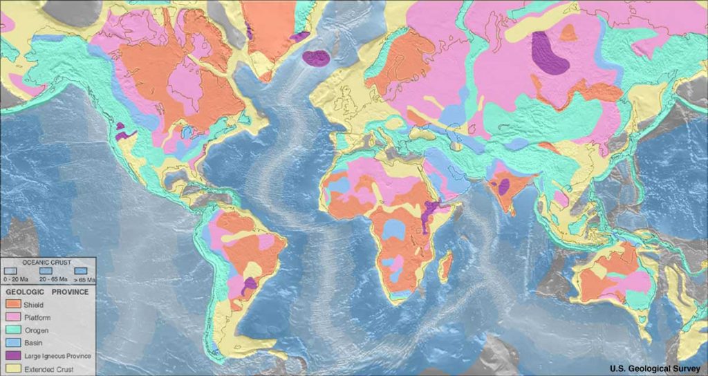
When plates of different densities converge, the higher density plate is pushed beneath the more buoyant plate in a process called subduction. When continental plates converge without subduction occurring, this process is called collision.
Subduction
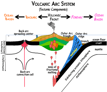
Subduction occurs when a dense oceanic plate meets a more buoyant plate, like a continental plate or warmer/younger oceanic plate, and descends into the mantle [45]. The worldwide average rate of oceanic plate subduction is 25 miles per million years, about a half-inch per year [46]. As an oceanic plate descends, it pulls the ocean floor down into a trench. These trenches can be more than twice as deep as the average depth of the adjacent ocean basin, which is usually three to four km. The Mariana Trench, for example, approaches a staggering 11 km [47].
 [<a data-cke-saved-href=\"http://creativecommons.org/licenses/by-sa/4.0\" href=\"http://creativecommons.org/licenses/by-sa/4.0\"")

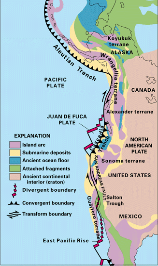
Within the trench, ocean floor sediments are scraped together and compressed between the subducting and overriding plates. This feature is called the accretionary wedge, mélange, or accretionary prism. Fragments of continental material, including microcontinents, riding atop the subducting plate may become sutured to the accretionary wedge and accumulate into a large area of land called a terrane [48]. Vast portions of California are comprised of accreted terranes [49].
When the subducting oceanic plate, or slab, sinks into the mantle, the immense heat and pressure push volatile materials like water and carbon dioxide into an area below the continental plate and above the descending plate called the mantle wedge. Through a process called fluid-induced melting covered in Chapter 4, magma is produced. The magma is more buoyant than the lithospheric plate above it and migrates to the Earth’s surface where it erupts as lava. The resulting volcanoes frequently appear as curved mountain chains, volcanic arcs, due to the curvature of the earth.
Subduction zones are known for having the largest earthquakes and tsunamis; they are the only places with fault surfaces large enough to create magnitude-9 earthquakes. These subduction-zone earthquakes not only are very large but also are very deep.
Oceanic-Continental Subduction

Oceanic-continental subduction occurs when an oceanic plate dives below a continental plate. This convergent boundary has a trench and mantle wedge and frequently, a volcanic arc. Well-known examples of continental volcanic arcs are the Cascade Mountains in the Pacific Northwest [63] and the Western Andes Mountains in South America [64].
Oceanic-Oceanic Subduction

The boundaries of oceanic-oceanic subduction zones show very different activity from those involving oceanic-continental plates. Since both plates are made of oceanic lithosphere, it is usually the older plate that subducts because it is colder and denser. The volcanism on the overlying oceanic plate may remain hidden underwater. If the volcanoes rise high enough the reach the ocean surface, the chain of volcanism forms an island arc. Examples of these island arcs include the Aleutian Islands in the northern Pacific Ocean, Lesser Antilles in the Caribbean Sea, and numerous island chains scattered throughout the western Pacific Ocean [65].
Collisions

When continental plates converge, during the closing of an ocean basin, for example, subduction is not possible between the equally buoyant plates. Instead of one plate descending beneath another, the two masses of continental lithosphere slam together in a process known as collision [66]. Without subduction, there is no magma formation and no volcanism. Collision zones are characterized by tall, non-volcanic mountains; a broad zone of frequent, large earthquakes; and very little volcanism.
When oceanic crust connected by a passive margin to continental crust completely subducts beneath a continent, an ocean basin closes, and continental collision begins. Eventually, as ocean basins close, continents join together to form a massive accumulation of continents called a supercontinent.
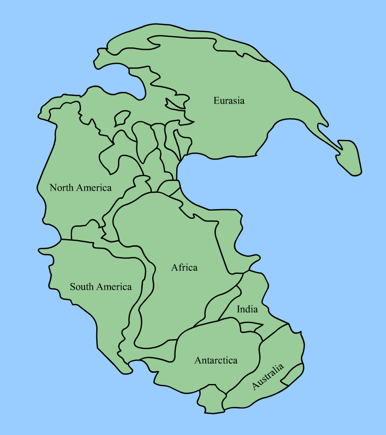
The process of collision created Pangea, the supercontinent envisioned by Wegener. Geologists now have evidence that continental plates have been continuously converging into supercontinents and splitting into smaller basin-separated continents throughout Earth’s existence, calling this process the supercontinent cycle, a process that takes place in approximately 500 million years. For example, they estimate Pangea began separating 200 million years ago. Pangea was preceded by an earlier supercontinents, one of which being Rodinia, which existed 1.1 billion years ago and started breaking apart 800 million to 600 million years ago.
References
- 45. Stern, R. J. A subduction primer for instructors of introductory geology courses and authors of introductory-geology textbooks. J. Geosci. Educ. 46, 221 (1998).
- 46. Tatsumi, Y. The subduction factory: how it operates in the evolving Earth. GSA Today 15, 4 (2005).
- 47. Todo, Y., Kitazato, H., Hashimoto, J. & Gooday, A. J. Simple foraminifera flourish at the ocean’s deepest point. Science 307, 689 (2005).
- 48. Schermer, E. R., Howell, D. G. & Jones, D. L. THE ORIGIN OF ALLOCHTHONOUS TERRANES: Perspectives on the Growth and shaping of Continents. Annual Review of Earth and Planetary Sciences 12, 107 (1984).
- 49. Moores, E. M., Sloan, D. & Stout, D. L. Classic Cordilleran Concepts: A View from California. (Geological Society of America, 1999).
- 63. Geller, D. Cascadia subduction zone volcanism in British Columbia. academic.emporia.edu (2008).
- 64. De Silva, S. L. & Francis, P. W. Volcanoes of the central Andes. (Springer, 1991).
- 65. Smith, A. L. & Roobol, M. J. Mt. Pelée, Martinique; A Study of an Active Island-arc Volcano. Geological Society of America Memoirs 175, 1–110 (1990).
- 66. O’Brien, P. J. Subduction followed by collision: Alpine and Himalayan examples. Phys. Earth Planet. Inter. 127, 277–291 (2001).
- 67. Ernst, W. G. Preservation/exhumation of ultrahigh-pressure subduction complexes. Lithos 92, 321–335 (2006).