
1.2: Soil Genesis
- Page ID
- 16606

\( \newcommand{\vecs}[1]{\overset { \scriptstyle \rightharpoonup} {\mathbf{#1}} } \)
\( \newcommand{\vecd}[1]{\overset{-\!-\!\rightharpoonup}{\vphantom{a}\smash {#1}}} \)
\( \newcommand{\id}{\mathrm{id}}\) \( \newcommand{\Span}{\mathrm{span}}\)
( \newcommand{\kernel}{\mathrm{null}\,}\) \( \newcommand{\range}{\mathrm{range}\,}\)
\( \newcommand{\RealPart}{\mathrm{Re}}\) \( \newcommand{\ImaginaryPart}{\mathrm{Im}}\)
\( \newcommand{\Argument}{\mathrm{Arg}}\) \( \newcommand{\norm}[1]{\| #1 \|}\)
\( \newcommand{\inner}[2]{\langle #1, #2 \rangle}\)
\( \newcommand{\Span}{\mathrm{span}}\)
\( \newcommand{\id}{\mathrm{id}}\)
\( \newcommand{\Span}{\mathrm{span}}\)
\( \newcommand{\kernel}{\mathrm{null}\,}\)
\( \newcommand{\range}{\mathrm{range}\,}\)
\( \newcommand{\RealPart}{\mathrm{Re}}\)
\( \newcommand{\ImaginaryPart}{\mathrm{Im}}\)
\( \newcommand{\Argument}{\mathrm{Arg}}\)
\( \newcommand{\norm}[1]{\| #1 \|}\)
\( \newcommand{\inner}[2]{\langle #1, #2 \rangle}\)
\( \newcommand{\Span}{\mathrm{span}}\) \( \newcommand{\AA}{\unicode[.8,0]{x212B}}\)
\( \newcommand{\vectorA}[1]{\vec{#1}} % arrow\)
\( \newcommand{\vectorAt}[1]{\vec{\text{#1}}} % arrow\)
\( \newcommand{\vectorB}[1]{\overset { \scriptstyle \rightharpoonup} {\mathbf{#1}} } \)
\( \newcommand{\vectorC}[1]{\textbf{#1}} \)
\( \newcommand{\vectorD}[1]{\overrightarrow{#1}} \)
\( \newcommand{\vectorDt}[1]{\overrightarrow{\text{#1}}} \)
\( \newcommand{\vectE}[1]{\overset{-\!-\!\rightharpoonup}{\vphantom{a}\smash{\mathbf {#1}}}} \)
\( \newcommand{\vecs}[1]{\overset { \scriptstyle \rightharpoonup} {\mathbf{#1}} } \)
\( \newcommand{\vecd}[1]{\overset{-\!-\!\rightharpoonup}{\vphantom{a}\smash {#1}}} \)
\(\newcommand{\avec}{\mathbf a}\) \(\newcommand{\bvec}{\mathbf b}\) \(\newcommand{\cvec}{\mathbf c}\) \(\newcommand{\dvec}{\mathbf d}\) \(\newcommand{\dtil}{\widetilde{\mathbf d}}\) \(\newcommand{\evec}{\mathbf e}\) \(\newcommand{\fvec}{\mathbf f}\) \(\newcommand{\nvec}{\mathbf n}\) \(\newcommand{\pvec}{\mathbf p}\) \(\newcommand{\qvec}{\mathbf q}\) \(\newcommand{\svec}{\mathbf s}\) \(\newcommand{\tvec}{\mathbf t}\) \(\newcommand{\uvec}{\mathbf u}\) \(\newcommand{\vvec}{\mathbf v}\) \(\newcommand{\wvec}{\mathbf w}\) \(\newcommand{\xvec}{\mathbf x}\) \(\newcommand{\yvec}{\mathbf y}\) \(\newcommand{\zvec}{\mathbf z}\) \(\newcommand{\rvec}{\mathbf r}\) \(\newcommand{\mvec}{\mathbf m}\) \(\newcommand{\zerovec}{\mathbf 0}\) \(\newcommand{\onevec}{\mathbf 1}\) \(\newcommand{\real}{\mathbb R}\) \(\newcommand{\twovec}[2]{\left[\begin{array}{r}#1 \\ #2 \end{array}\right]}\) \(\newcommand{\ctwovec}[2]{\left[\begin{array}{c}#1 \\ #2 \end{array}\right]}\) \(\newcommand{\threevec}[3]{\left[\begin{array}{r}#1 \\ #2 \\ #3 \end{array}\right]}\) \(\newcommand{\cthreevec}[3]{\left[\begin{array}{c}#1 \\ #2 \\ #3 \end{array}\right]}\) \(\newcommand{\fourvec}[4]{\left[\begin{array}{r}#1 \\ #2 \\ #3 \\ #4 \end{array}\right]}\) \(\newcommand{\cfourvec}[4]{\left[\begin{array}{c}#1 \\ #2 \\ #3 \\ #4 \end{array}\right]}\) \(\newcommand{\fivevec}[5]{\left[\begin{array}{r}#1 \\ #2 \\ #3 \\ #4 \\ #5 \\ \end{array}\right]}\) \(\newcommand{\cfivevec}[5]{\left[\begin{array}{c}#1 \\ #2 \\ #3 \\ #4 \\ #5 \\ \end{array}\right]}\) \(\newcommand{\mattwo}[4]{\left[\begin{array}{rr}#1 \amp #2 \\ #3 \amp #4 \\ \end{array}\right]}\) \(\newcommand{\laspan}[1]{\text{Span}\{#1\}}\) \(\newcommand{\bcal}{\cal B}\) \(\newcommand{\ccal}{\cal C}\) \(\newcommand{\scal}{\cal S}\) \(\newcommand{\wcal}{\cal W}\) \(\newcommand{\ecal}{\cal E}\) \(\newcommand{\coords}[2]{\left\{#1\right\}_{#2}}\) \(\newcommand{\gray}[1]{\color{gray}{#1}}\) \(\newcommand{\lgray}[1]{\color{lightgray}{#1}}\) \(\newcommand{\rank}{\operatorname{rank}}\) \(\newcommand{\row}{\text{Row}}\) \(\newcommand{\col}{\text{Col}}\) \(\renewcommand{\row}{\text{Row}}\) \(\newcommand{\nul}{\text{Nul}}\) \(\newcommand{\var}{\text{Var}}\) \(\newcommand{\corr}{\text{corr}}\) \(\newcommand{\len}[1]{\left|#1\right|}\) \(\newcommand{\bbar}{\overline{\bvec}}\) \(\newcommand{\bhat}{\widehat{\bvec}}\) \(\newcommand{\bperp}{\bvec^\perp}\) \(\newcommand{\xhat}{\widehat{\xvec}}\) \(\newcommand{\vhat}{\widehat{\vvec}}\) \(\newcommand{\uhat}{\widehat{\uvec}}\) \(\newcommand{\what}{\widehat{\wvec}}\) \(\newcommand{\Sighat}{\widehat{\Sigma}}\) \(\newcommand{\lt}{<}\) \(\newcommand{\gt}{>}\) \(\newcommand{\amp}{&}\) \(\definecolor{fillinmathshade}{gray}{0.9}\)Dan Pennock
Learning Objectives
After completing this chapter, the student will be able to:
- Explain why Canadian soils are young by global standards and the effect of their age on soil formation
- Describe the two main classes of soil parent materials at the national level
- Relate the two main genetic pathways for forest soils in Canada to the two broad classes of parent materials
- Identify the two main pathways for soil formation under water-saturated conditions in wetlands
- Explain the effect of frost-action in permafrost soils on soil formation
- Distinguish between grassland soils, forest soils, and wetland soils in terms of the effect of organic additions and the action of soil animals on soil formation
- Identify two distinct genetic pathways that occur in clay-rich parent materials in grasslands
- Explain the dominant pathway of soil formation in older, non-glaciated regions outside of Canada
INTRODUCTION TO SOIL GENESIS (PEDOLOGY)
A key goal of sustainable soil management is to match the practices we adopt with the specific properties of the soil. This can be difficult, however, when soils show major differences in their properties over very short distances. These differences in soil properties result from both properties they have inherited and the action of soil-forming processes during soil development. Both of these factors are studied in the sub-discipline of soil genesis or pedology, which is the focus of this chapter.
Soil genesis is underlain by two major concepts:
- soil properties result from the action and interaction of soil-forming (or pedogenic) processes; and
- the type and intensity of these pedogenic processes are governed by environmental factors – the conditions of the natural world in which the soils occur and the impact of human activity on these environmental factors.
Soil formation starts when fresh earth materials begin to be transformed by physical, chemical, and/or organic pedogenic processes. For the great majority of the Canadian land mass this moment of transformation began soon after the retreat of the great ice sheets that once covered most of Canada and the draining of the vast lake and river systems that followed the retreating ice front. The fresh glacial sediments were soon home to an assemblage of microbial, plant, and animal life that began to transform the glacial sediments into soil. In some places the landscape was then further modified by processes such as flowing water, wind, and gravity throughout the post-glacial period. The final wide-spread transformation of soils began with the European settlement of Canada and the imposition of their land uses on the soil.
This brief overview of soil formation in Canada establishes two key points needed to understand Canadian soils. First, Canadian soils are very young compared to most global soils (Sanborn, 2016). Post-glacial soil formation in Canada begins at about 17,000 years before present (yrs BP) at about the 49th Parallel (which is now our southern border with the United States of America). In comparison, in the center of the continents of Australia and Africa soil formation has been occurring since the start of the Mesozoic era 250 million years ago (Paton et al., 1995). Even compared to the southern areas of the USA or Europe, Canadian soils are very young.
In the ancient land surfaces of Australia or Africa the original rocks and sediments the soils formed in have been fundamentally altered by soil formation. In most Canadian soils, however, there has been little alteration of the rocks and sediments the soil formed in and hence many soil properties are directly inherited, as is the shape of the land surface itself. In soil science, the rocks and sediments the soil forms in are referred to as the parent material of the soil, and for Canadian soils inheritance of physical and chemical properties from the parent material is the major determinant of soil formation.
Second, in Canada the characteristic assemblages (or biomes) of climate, vegetation, and animals– for example, the tundra, Boreal forest, or grasslands – have largely been in place since soon after the ice sheets retreated. Most Canadian soils have developed in a stable biome and the soil properties reflect the distinctive set of soil processes associated with that biome. Hence in Canada we have characteristic zones of soils that are distinct and different from one another, resulting from these distinct and different sets of processes. In more ancient land surfaces the soils may reflect many episodes of environmental change, and the soil properties often reflect long-vanished environmental conditions.
Hence, at the national level, the soil formation factors that control the pedogenic processes are time (the duration of soil formation), parent material (the size and chemical composition of mineral material), climate (temperature and moisture within the soil), and organisms (vegetation, animals, and microbes that transform the mineral material). As we will see, at more local levels two other factors also control specific pedogenic processes: topography (which controls flows of water and sediments) and the presence of groundwater. Finally all soil properties can be profoundly influenced by human activity. These seven soil formation factors are examined in greater detail in Chapter 8 of this textbook.
Can You Dig It!
J.H. Ellis, Fellow of the Canadian Society of Soil Science 1963
Canadians on the whole generally tend to be rather humble people and are not known for great pronouncements of patriotism or promoting of our own. It is for this reason that very few know of the “groundbreaking” work of a Canadian soil scientist named Joseph Henry Ellis (1890-1973) whose work and musings greatly advanced our understanding of soils of Western Canada—and particularly of Manitoba. In his book The Soils of Manitoba (published in 1938) he described his understanding of why the soils in Manitoba were so diverse and distributed as they are:
“Soils are natural objects which have developed at the surface of the earth as the result of the action of climate on the geological deposits that are under the influence of organic life. Soils differ from the geological material over which they lie. These differences are shown by the physical and chemical characteristics of the soil which may be enumerated under the headings of colour, texture, structure, consistency, intrusions and concretions or products of soil weathering, reaction, etc. The sum of these characteristics determines the soil type (soil group).”
Professor Ellis went on to describe the factors that control the nature and distribution of soils in Manitoba (p 14). He listed these factors as:
- “The climate, or the temperature and moisture within the soil”;
- “The vegetation, which determines the type of organic matter added to the soil”;
- “The parent material, or the geological deposits which determine the minerals on which the soil is formed, and in turn affect the texture, the water retention capacity, and the mineral reserve”;
- “The position in which the soil is found in relationship to the topography”;
- “The presence or absence of ground water within the soil profile”;
- “The age or length of time the soil has been under the influence of its environment”; and
- “In the case of cultivated soils – the modifying effects of culture or the work of man.”
A contemporary of Professor Ellis in the United States, Professor Hans Jenny (1899-1992) of the University of California at Berkeley, published a work in 1941 called Factors of Soil Formation: A quantitative system of pedology (Jenny, 1941) in which he identified what he originally called Factors of Soil Formation—later referred to as State Factors (Jenny, 1980). He identified climate, organisms, relief (topography), parent material, and time as the five factors of soil formation that explained the distribution and nature of soils. Both Hans Jenny in the USA and Joe Ellis in Canada had identified similar factors to explain the distribution and nature of soils.
The above excerpt was adapted from an article originally published by Les Fuller in 2010 (http://www.prairiesoilsandcrops.ca): Chernozemic soils of the prairie region of western Canada. Prairie Soils and Crops 3: 37−45.
THE GEOLOGICAL LEGACY
The great majority of Canadian soils have formed in glacial or post-glacial sediments and often the bedrock occurs well below the zone of soil formation. The glacial and post-glacial sediments were, however, derived from bedrock pulverized by the glaciers and hence the nature of the pulverized bedrock is a very important control on the genetic pathway the soil follows. The minerals present in the parent material initially determine the chemical environment of the soil, especially its acidity and base cation concentration (see Chapter 5). As well, the particle size, or texture (see Chapter 4) of the mineral material is also originally inherited from the pulverized bedrock and then is further sorted by other geomorphic agents such as flowing water or wind. The Virtual Soil Science Learning Resources website has an excellent overview of the importance of parent material.
At the broadest level there are three major classes of rocks in Canada (Figure 2.1): igneous, sedimentary, and metamorphic. Igneous rocks form within the crust (referred to as intrusive or plutonic rocks on Figure 2.1) or through volcanic activity (volcanic rocks). Sedimentary rocks form from sediments or chemical compounds that were eroded and deposited in ancient oceans or land surfaces and then through time subsequently made into rock (or lithified). Metamorphic rocks are formed through transformation of existing igneous or sedimentary rocks by temperature or pressure or by chemical factors and their properties reflect the parent rock (i.e., igneous or sedimentary) from which they are formed.
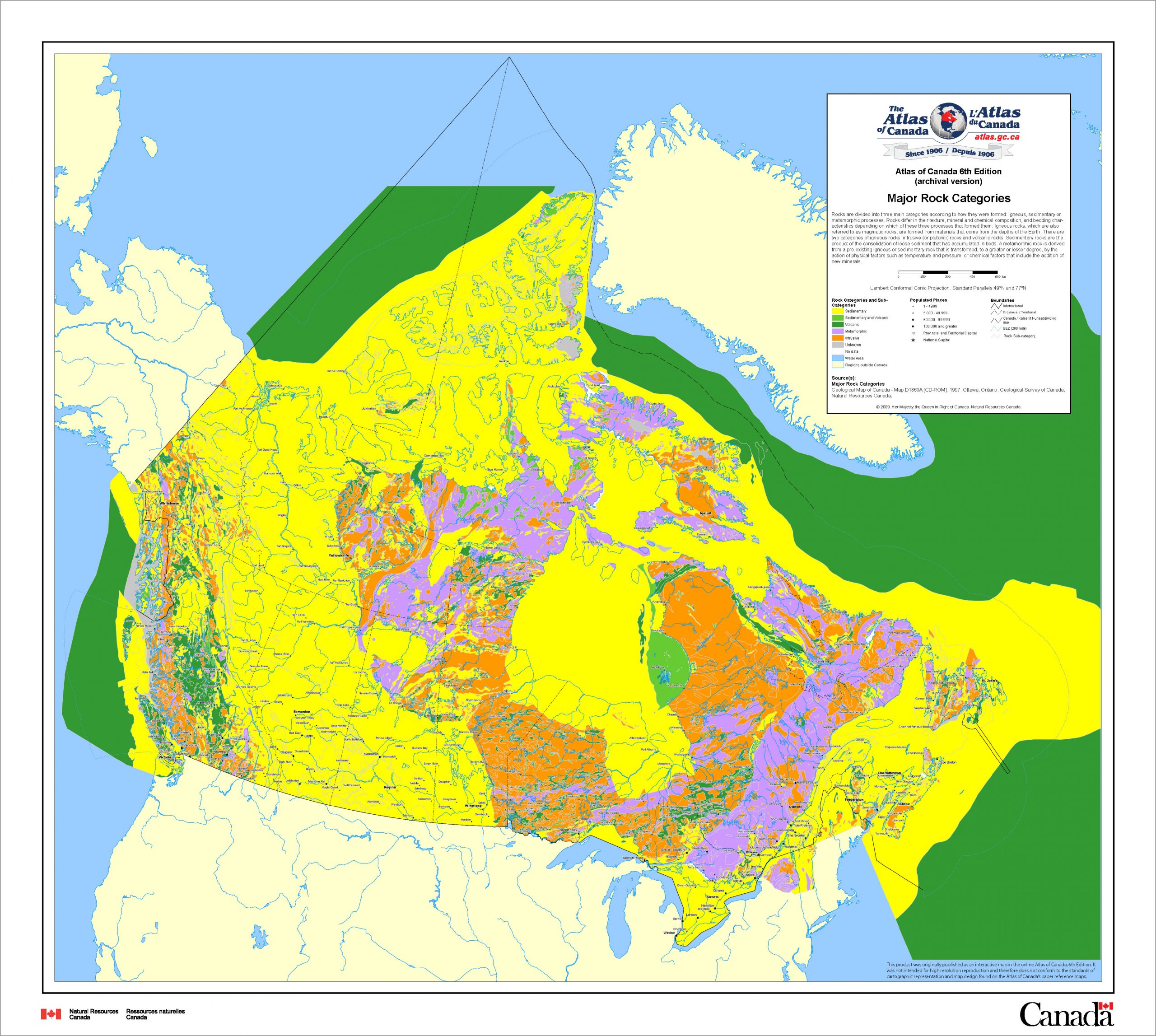
Igneous rocks are dominated by silicate (i.e., oxygen-silicon dominated) minerals such as micas, feldspars, quartz, olivine, pyroxene, and amphiboles, all of which are formed through the cooling and solidification of magma. The cooling process in the earth’s crust typically produce minerals of large, sand-sized particles and the resulting rock mass is very resistant to crushing and pulverization by glaciers. The greatest extent of igneous rocks is associated with the Canadian Shield, which is one of the most ancient rock bodies in the Earth. There are also extensive areas of igneous rocks in the interior and west coast of British Columbia.
Sedimentary rocks form through deposition of material (particles and chemical ions) eroded from ancient landscapes. Sedimentary rocks are dominant in the Prairies, eastern Rocky Mountains, and through to the Arctic Ocean and Arctic islands. They are also dominant in southern Ontario and Quebec and much of the Maritime provinces.
Sedimentary rocks can be broadly divided into three main classes: clastic rocks (formed from consolidation of preexisting particles such as sand, silt or clay); biochemical (or biogenic, meaning formed through the actions of living organisms) rocks such as limestone or coal; and chemical rocks formed by precipitation of ions to form salts such as halite (rock salt) The sediments that form sedimentary rocks were commonly deposited in ocean (or marine) environments. The sediments that form sedimentary rocks were originally deposited in layers and hence the sedimentary rocks are bedded. Their bedded nature and the structure of the minerals present in them make them more susceptible than igneous rocks to breakup and pulverization by glaciers.
The sediments that form clastic rocks are sorted into sand- (sandstone), silt- (siltstone), or clay-sized (shale, mudstone) particles. Clay minerals in shales are silicates with a distinctive layer or sheet structure (called phyllosilicates) that form in the near-surface zone of the earth at much lower pressures and temperatures than the minerals in igneous rocks. Clay minerals in Canadian soils are almost entirely inherited from these parent rocks. For pedogenetic purposes there is an important distinction between clay minerals such as smectite, which allows water between its structural layers and hence swells and shrinks as soil moisture conditions change, and other major minerals such as mica, vermiculite and chlorite that do not shrink and swell. Smectite clay minerals are in large part inherited from the Cretaceous marine sedimentary rocks that underlie the Prairie ecozone (see Chapter 14 for more information on minerals in Canadian soils).
Limestone is the most common biogenic rock and the dominant mineral in limestone is calcium carbonate. Chemical rocks often contain a wide variety of salts formed between cations (positively charged ions) such as sodium and magnesium and anions (negatively charged ions) such as carbonate and chloride.
The differences in mineral composition between the igneous and sedimentary rocks strongly influences the chemistry of the soil and, at a very broad level, determines the genetic pathway the soil will follow. First, the presence of carbonates in parent materials formed from sedimentary rocks maintains the soil pH in a range between 5 to 8.5, whereas soils formed in parent materials derived from igneous rocks are typically more acidic (pH levels from 3.5 to 5). As we will see in Chapter 8, this threshold for pH is an important classification criterion in the Canadian System of Soil Classification (Soil Classification Working Group, 1998). Second, base cations such as calcium, magnesium, potassium, and sodium are plant nutrients (see Chapter 7), and the higher content of these cations in sedimentary rock-derived parent materials makes them inherently more fertile than the more acidic, igneous-rock derived soils.
THE GLACIAL LEGACY
The Canadian land surface was greatly changed by the ice sheets of the Pleistocene Epoch, which lasted from 2.5 million years ago to approximately 11,700 years ago (Subcommission on Quaternary Stratigraphy). The Pleistocene Epoch was followed by the Holocene Epoch, which extends from the end of the Pleistocene to the present day. During the Pleistocene Epoch there were many episodes of glacial ice formation, advance, and retreat but for soil science in Canada we are most concerned with the final glaciation. In North America this final episode is informally called the Wisconsinan glaciation.
Glacial sediments
The great ice sheets are responsible for the majority of sediments that Canadian soils have formed in and for the shape of the land surface itself (Figure 2.2). The texture and mineralogy of glacial sediments result from the pulverization of the underlying bedrock surface by the ice sheets; the ice sheets break up the bedrock and then grind it into smaller and smaller pieces during transport. The two main types of rocks differ greatly in the resistance they offer to the ice sheets. Igneous rock surfaces are generally much more resistant to disturbance by glaciers, and yield sediments high in gravel and sand-sized particles dominantly of quartz. Sedimentary rocks are much more readily pulverized, and yield a mixture of particles sizes from gravel to clay.
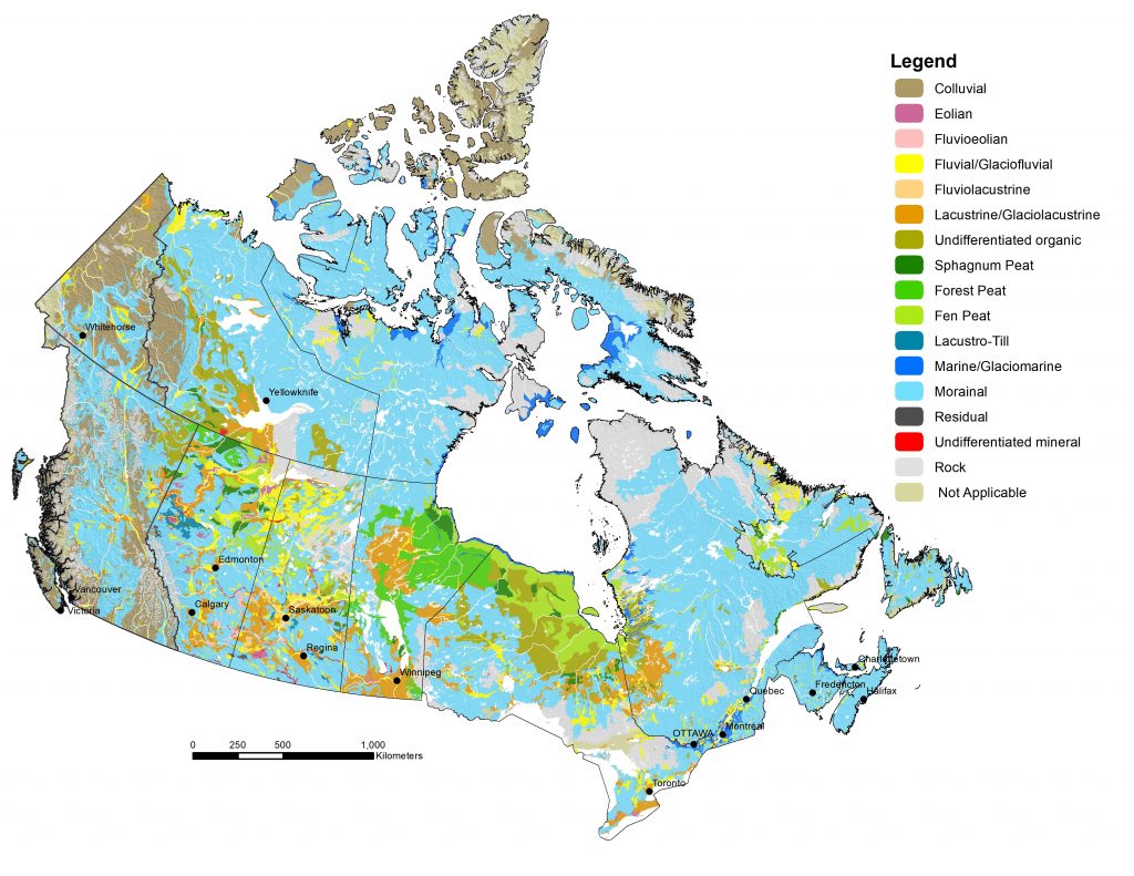
Initially the pulverized rock was transported by the great ice sheets and considerable mixing of crushed rock from different sources occurred. This mixed sediment is called till or moraine, which are synonymous terms. Morainal parent materials are by far the most common in Canada (Figure 2.2). In areas underlain by igneous rock, till is dominated by gravel and sand-sized material (Sims and Baldwin, 1991); in sedimentary rock areas, tills are more commonly a mixture of gravel, sand, silt, and clay sized particles. Till can be deposited directly as a basal layer under the ice, as material which melts out from a stagnant ice mass, or as material which flows off the surface of a stagnant ice mass.
At the end of the Wisconsinan glaciation the ice mass began to melt faster than new ice formed, and the front of the glacier began to recede (Dyke, 2004). The period of glacial retreat produced vast amounts of melt water, which carved channels into the underlying till and bedrock surfaces. The melt-water from the glaciers carried a high sediment load, and this material was deposited in huge floodplains and deltas. River or stream systems are generally called fluvial systems and deposits from glacial rivers are called glacio-fluvial sediments. Glacio-fluvial sediments are most common in the Prairie provinces but can be found throughout Canada (Figure 2.2).
In some locations, the glacial melt water was impounded in glacial lakes in front of or even on top of the ice sheets. Deltas of coarse sediments formed at the point where rivers entered the glacial lakes, and the reduced flow of the water could no longer suspend these larger materials. Fine sand, silt, and clay sediments were sequentially deposited in the relatively still waters further out in the lakes. Lake systems are called lacustrine systems and deposits from glacial lakes are called glacio-lacustrine sediments. The most extensive areas of glacio-lacustrine deposits occur in Manitoba, the Clay Belt of Ontario and Quebec, and around Great Slave Lake in the North-West Territories (Figure 2.2). Smaller glacio-lacustrine surfaces occur in southern Saskatchewan and Alberta and the high silt and clay contents make for excellent agricultural soils.
At the continental margins the land surface rebounded from the compression caused by the great ice sheets and near-shore areas of marine sediments were exposed to the atmosphere and soil formation; these are called marine or glacio-marine sediments. Flooding of the St. Lawrence valley by the ocean left deposits of glacio-marine clays in eastern parts of the Mixedwood Plains ecozone around Ottawa and Montreal. The Hudson Plain ecozone south of Hudson Bay has glacio-marine sediments overlain by deposits of peat formed in the post-glacial period.
In some locations glacial erosion scoured away any sediments, and left behind exposed rock surfaces (Figure 2.2). These exposed rock surfaces are most common in the Canadian Shield. Rock is also the surface material in many parts of the mountains of western Canada. Due to the short time for soil development in Canada little or no alteration of the exposed rock surface has occurred.
Glacial landscapes
While the largest terrain features such as the western Cordillera, Appalachian Mountains, and the High Arctic mountains are the result of mountain-building episodes triggered by plate tectonics, the shape of the landscape elsewhere in Canada is primarily the result of glacial erosion and deposition.
At the broadest scale there are differences in glacially-induced surface forms between areas underlain by igneous rocks and those of sedimentary rock. The resistant, igneous rocks yield limited amounts of tills high in sand and gravel, and tills are generally thin and the rolling underlying bedrock surface is evident. There are also many landforms associated with flowing water at the front or within the ice sheet such as outwash plains and eskers (i.e., sediments from rivers flowing within the ice mass).
In the regions underlain by sedimentary rocks, the pulverization of the rocks yielded much greater quantities of glacial sediment and often there is little expression of the underlying bedrock surface. For example, in the Prairies there is a band of thick (100 to 300 m) of glacial sediments that runs parallel to the Canadian Shield and generally gets thinner as we move to the south-west of the plains (Fenton et al., 1994). In Southern Ontario, the glacial sediments are thickest (200 – 260 m) at the contact with the Canadian Shield and then again in Lake Erie Lowland Ecoregion. In areas with thick glacial deposits a range of surface forms associated with specific types of glacial deposition occur (Table 2.1).
Table 2.1. Materials and surface appearance of major glacial sediments
| Sediment Type | Material Description | Surface Appearance |
|---|---|---|
| Till | Till is deposited directly from glacial ice, and is composed of an unsorted mixture of sand, silt, clay, and gravel. The gravel is distributed throughout the material. The dominant soil textures are loams. | Till landscapes are often hummocky (knolls and sloughs) or undulating. They commonly have gravel on the soil surface. |
| Glacio-fluvial gravels | The channels of the swiftly flowing glacial streams were composed of well-sorted sand and gravel layers. | Relatively flat landscapes; former bars in the rivers may form low, flat topped hills. |
| Glacio-fluvial sands | The floodplains of the former glacial streams and the deltas where the streams entered water bodies are often composed of well-sorted sand deposits (sand, loamy sand, or sandy loam). The size of the sand ranges from coarse sand to very fine sand. | The surface expression is often undulating; few stones are apparent. |
| Glacio-lacustrine silts and clays | The still waters of the glacial lakes allowed the fine silt and clay deposits to settle out of the water and be deposited. These layers may be well-sorted silt (silt or silt loam), clay (heavy clay, clay, or clay loam), or alternating thin layers of silt and clay (called varves). | Generally these are flat landscapes with few hills. Stones are very uncommon. In a few places, the lakes were formed on top of the ice sheets; these glacial deposits have a hummocky appearance. |
The Holocene Legacy
Many areas of the Canadian land surface have been further modified by geomorphic processes since glaciation, through the actions of wind, water, gravity, or saturation (Table 2.2) during the Holocene.
Table 2.2. Materials and surface appearance of major post-glacial sediments in Canada
| Sediment Type | Material Description | Surface Appearance |
|---|---|---|
| Loess | A layer which was transported and deposited by the wind, termed ‘eolian’. The loess forms a silty mantle over top of the underlying glacial sediments | Generally very smooth landscapes with long, gentle slopes |
| Dune sand or cover sand | Often the glacio-fluvial sands originally deposited in deltas or shorelines that have been reworked by the wind during the Holocene. | Complex series of slopes characteristic of sand dune areas. |
| Fluvial or alluvial | Flooding of the current fluvial channels leaves behind deposits of sand, silt, and clay in a floodplain. | Confined to the floodplains of the fluvial systems; generally level landscapes or gently undulating. |
| Colluvium | Transport of sediment from steep slopes of river channels, escarpments etc.; deposition commonly occurs at the base of the slope. | Associated with steep slopes. |
| Peat | Organic layer formed by incomplete decomposition of plant inputs due to saturated conditions | Generally level wetland surface occupied by trees, shrubs, and/or mosses |
| Marine | Shoreline and coastal sediments exposed due to land surface rebound following deglaciation | Generally level surfaces with raised beach ridges |
Wind can be an important geomorphic agent, especially for lacustrine and fluvial sediments dominated by silt and sand. Geomorphologists refer to wind action as eolian processes. Immediately following glaciation wind action on floodplains and lakes detached silt from the surface and deposited silt layers (or loess) downwind of the source area. Loess areas are found throughout the globe and are often very important agricultural areas, but only limited areas of post-glacial loess occur in Canada – the only large area mapped on the parent material map of Canada is in southwestern Saskatchewan. Thin (10 to 30 cm) loess caps are very common in alpine and many Arctic landscapes as well but are too discontinuous to appear on the national map.
Glacial deltas and floodplains were also sources of sand-sized particles that were eroded by wind and then deposited in characteristic sand dune areas. Some areas like the Great Sand Hills of Saskatchewan remain active to this day. Sand dune areas are also commonly found in the shorelines of modern lakes and oceans throughout Canada.
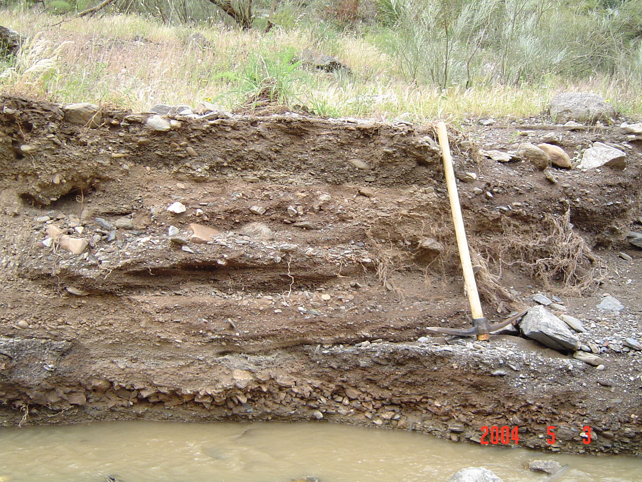
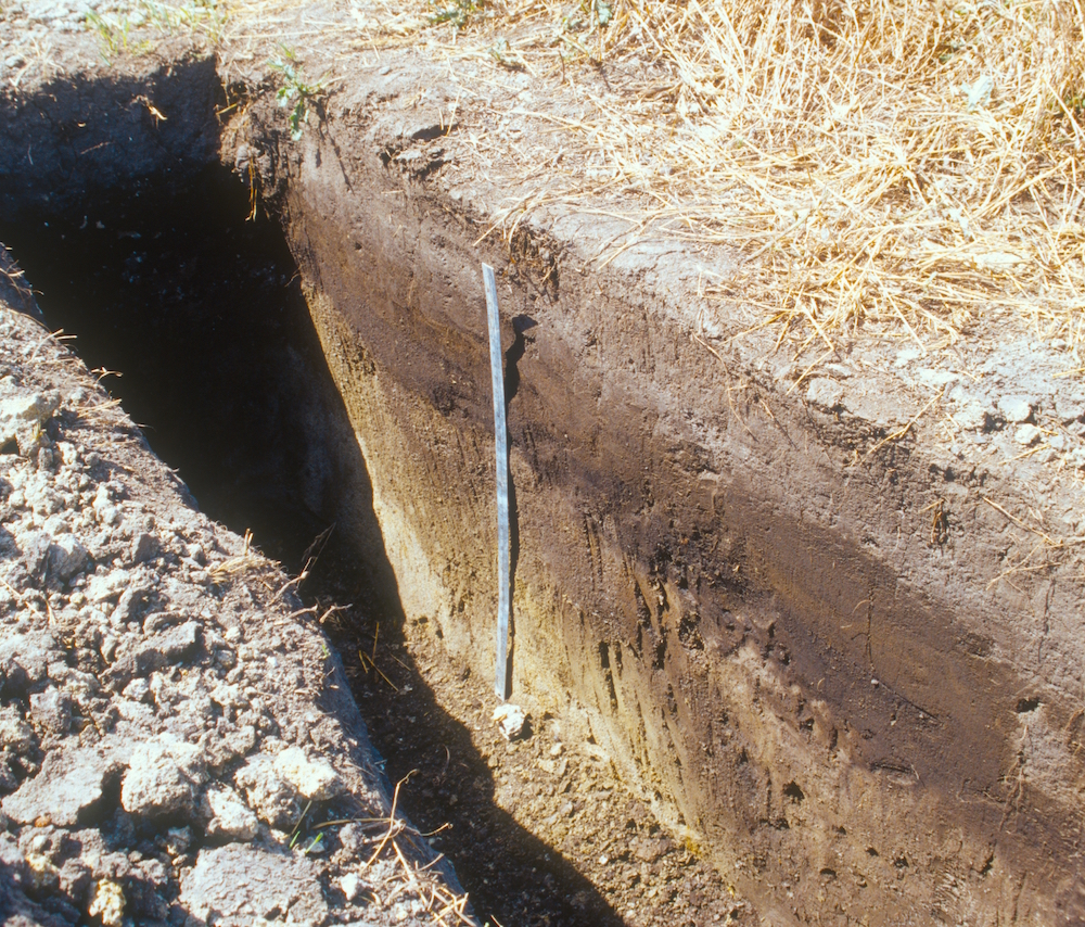
Water is also a major geomorphic agent and is responsible for landform creation in modern floodplains throughout Canada. Like wind, water transports and separates sediments into different size fractions, and floodplains often have discrete areas of gravel, sand, silt, and clay deposition. Often floodplains are built up over time by different flood events and distinct layers of different sediments occur; these are referred to as cumulic layers by soil scientists (Figure 2.3).
Wherever relatively steep slopes occur sediments are transported downslope by gravity in a process known as colluviation. The texture of the colluvial deposits reflect the properties of the source sediment. In mountain areas like the Western Cordillera colluvial transport of till mantles is very common, and these colluvial layers often consist of loams with a high stone content.
Finally, one of the largest areas of Holocene-aged soils is the Hudson Plains Ecozone, which was exposed to the atmosphere and soil formation as the ocean receded due to the rebound of the land surface following melting of the great ice sheets. The recession of the ocean is marked by a series of raised beach ridges that mark the former shoreline of Hudson Bay.
Paleosols and climate change
Paleosols (ancient soils) are soils that have formed under climate and vegetation regimes very different from those that currently occur in an area. The properties of paleosols can be used to reconstruct past climate and are an important tool in the paleoclimatic research.
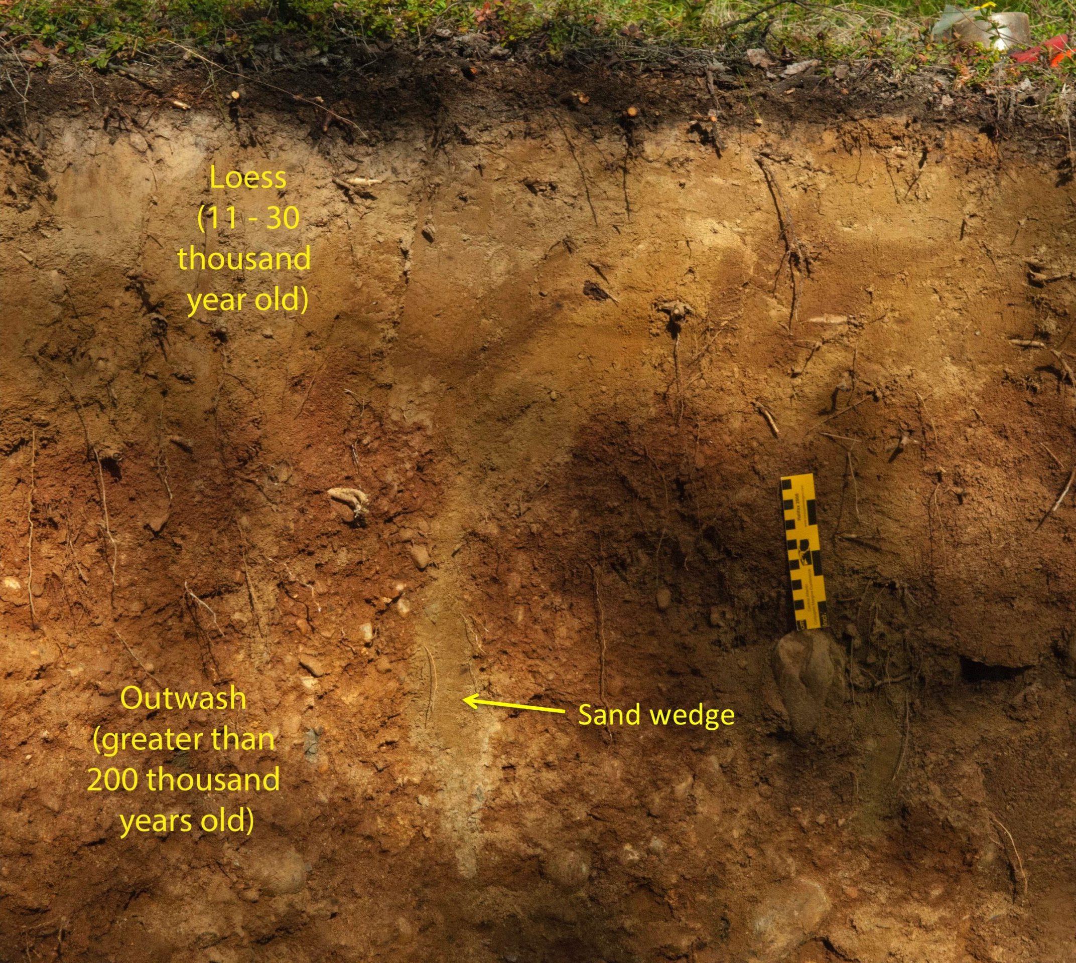
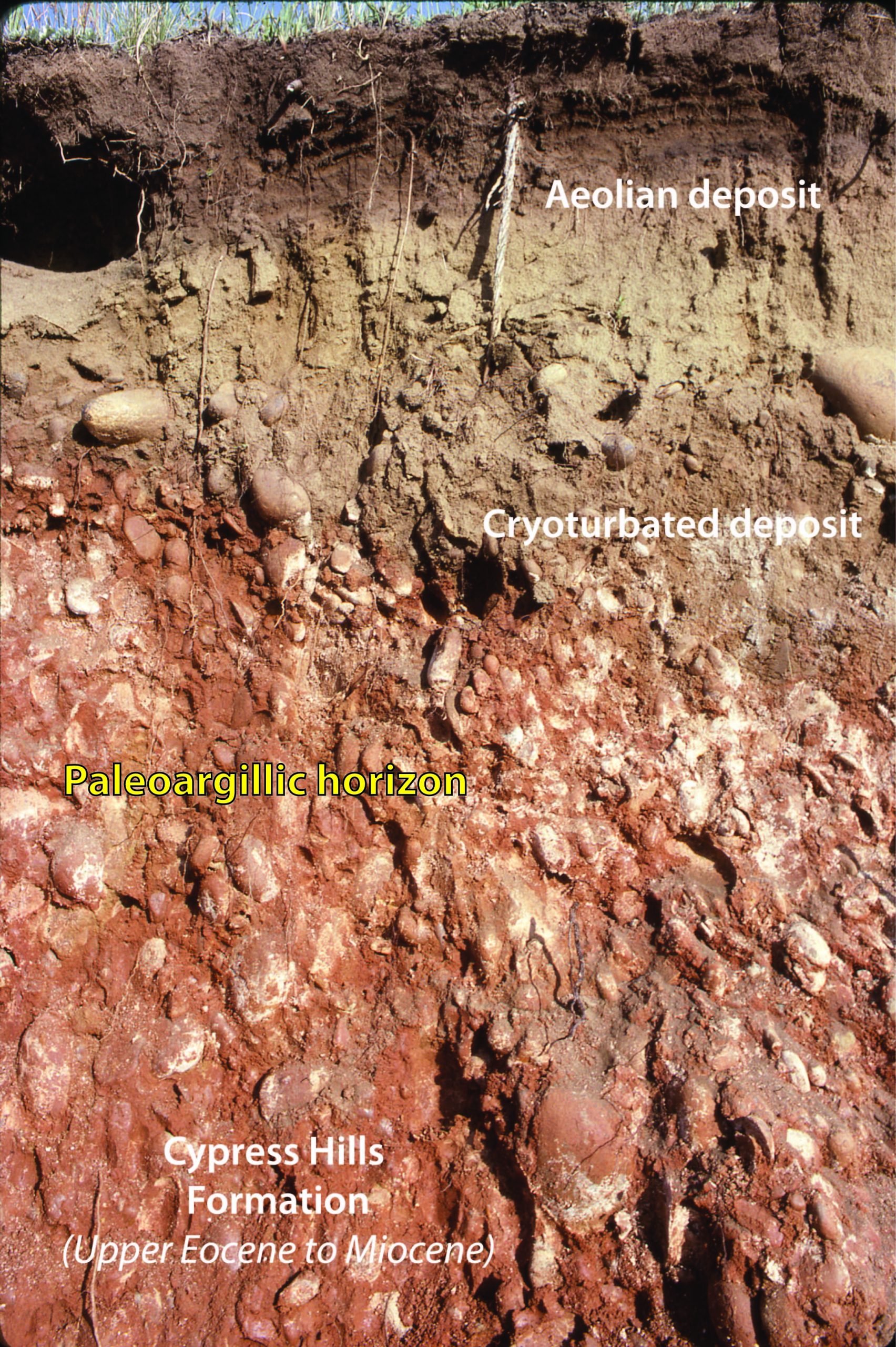
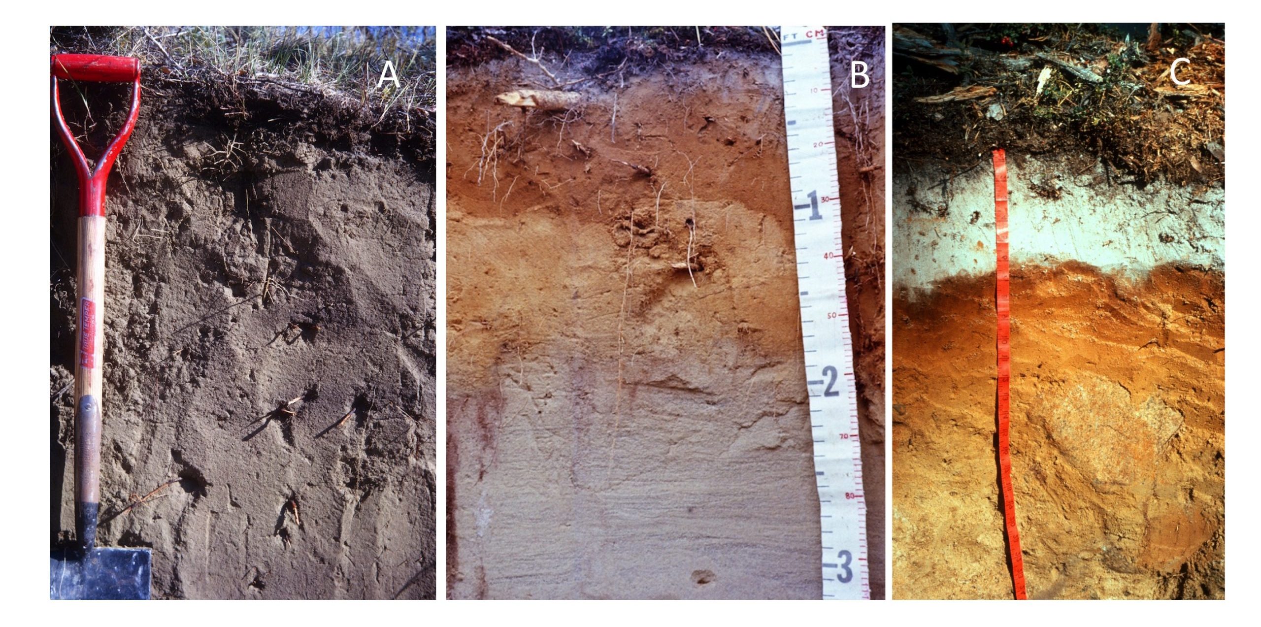
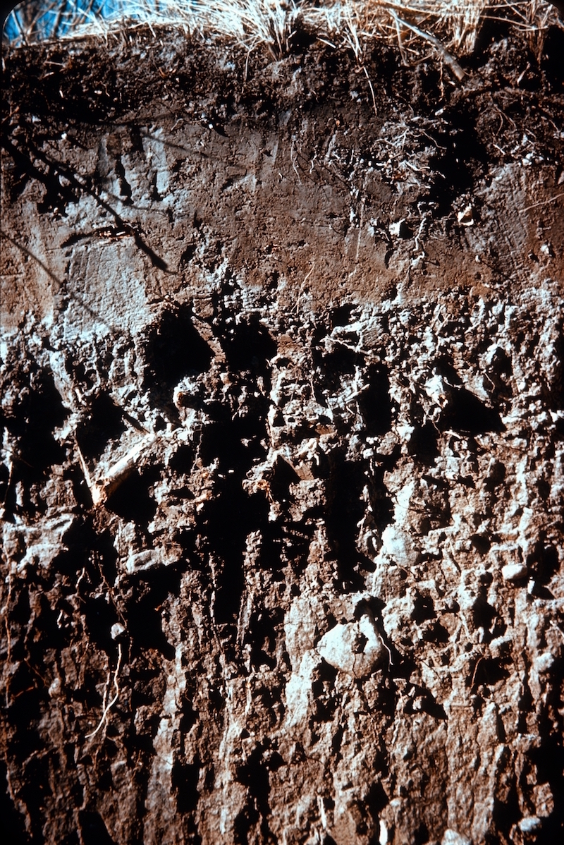
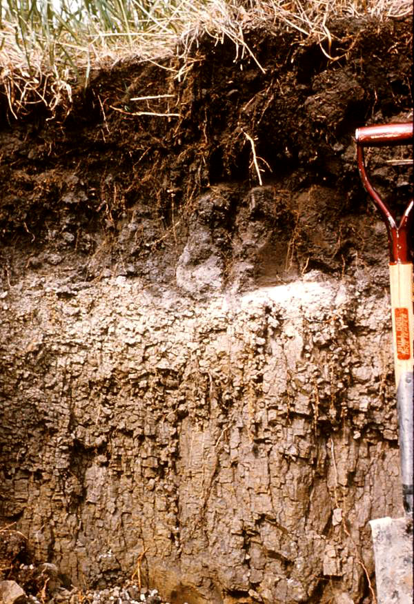
Only a few areas of Canada were not glaciated and the soils of these unglaciated regions reflect soil formation over much longer time periods than most Canadian soils (Sanborn, 2016). The west-central area of the Yukon was not glaciated, and the paleosols found in this area are more fully developed than the soils found adjacent to them in glaciated regions. The paleosols often have a mantle of loess over the older soil, and ample evidence of mixing caused by frost processes in the soil (Figure 2.4) (Sanborn, 2016). The other area with unglaciated soils is the Cypress Hills of southwestern Saskatchewan, which were not overridden by glaciers. Again the paleosols of the Cypress Hills are much more highly developed than adjacent soils and also have a layer of loess capping the older soil layers (Figure 2.5) (Sanborn, 2016).
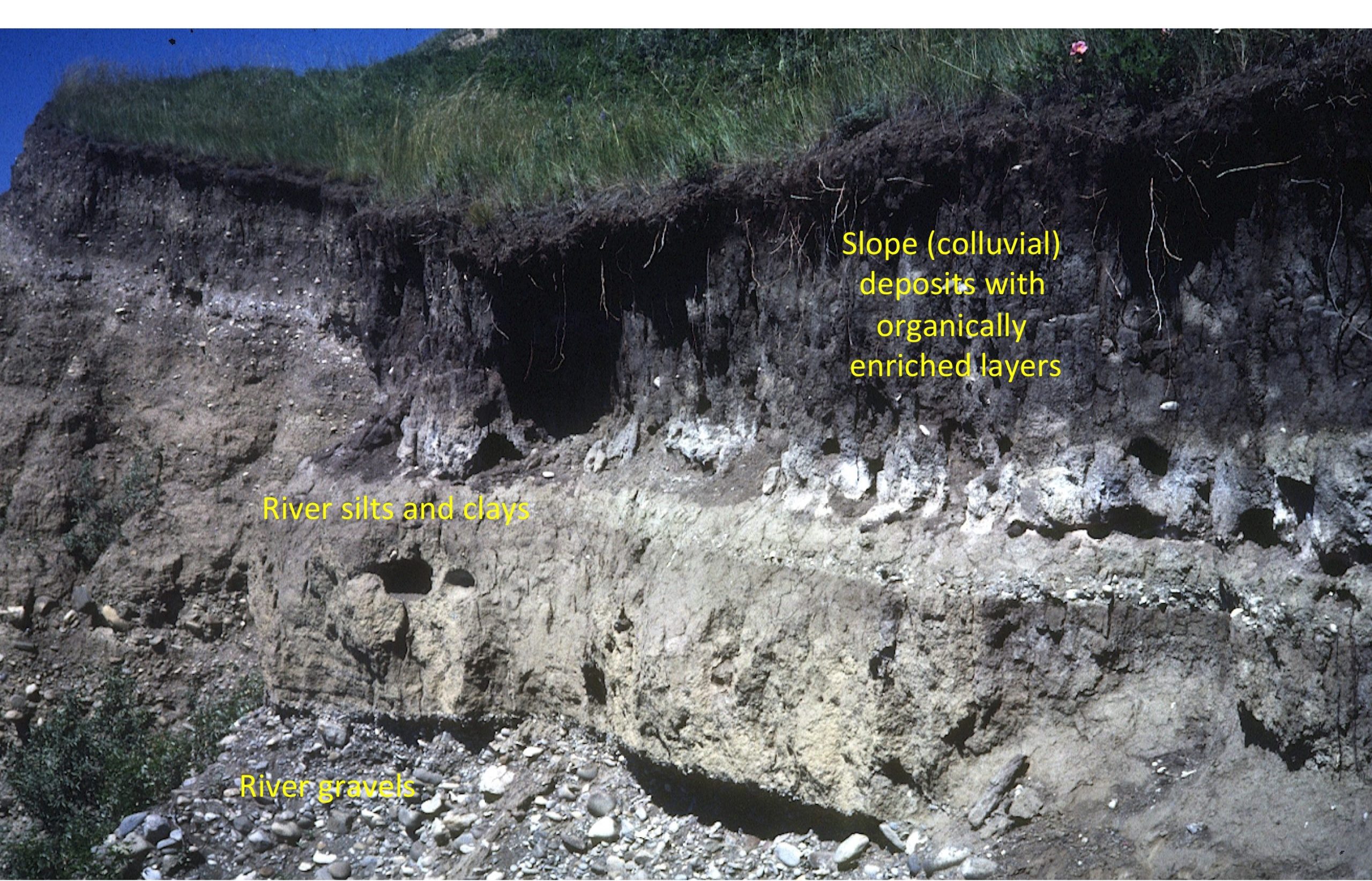
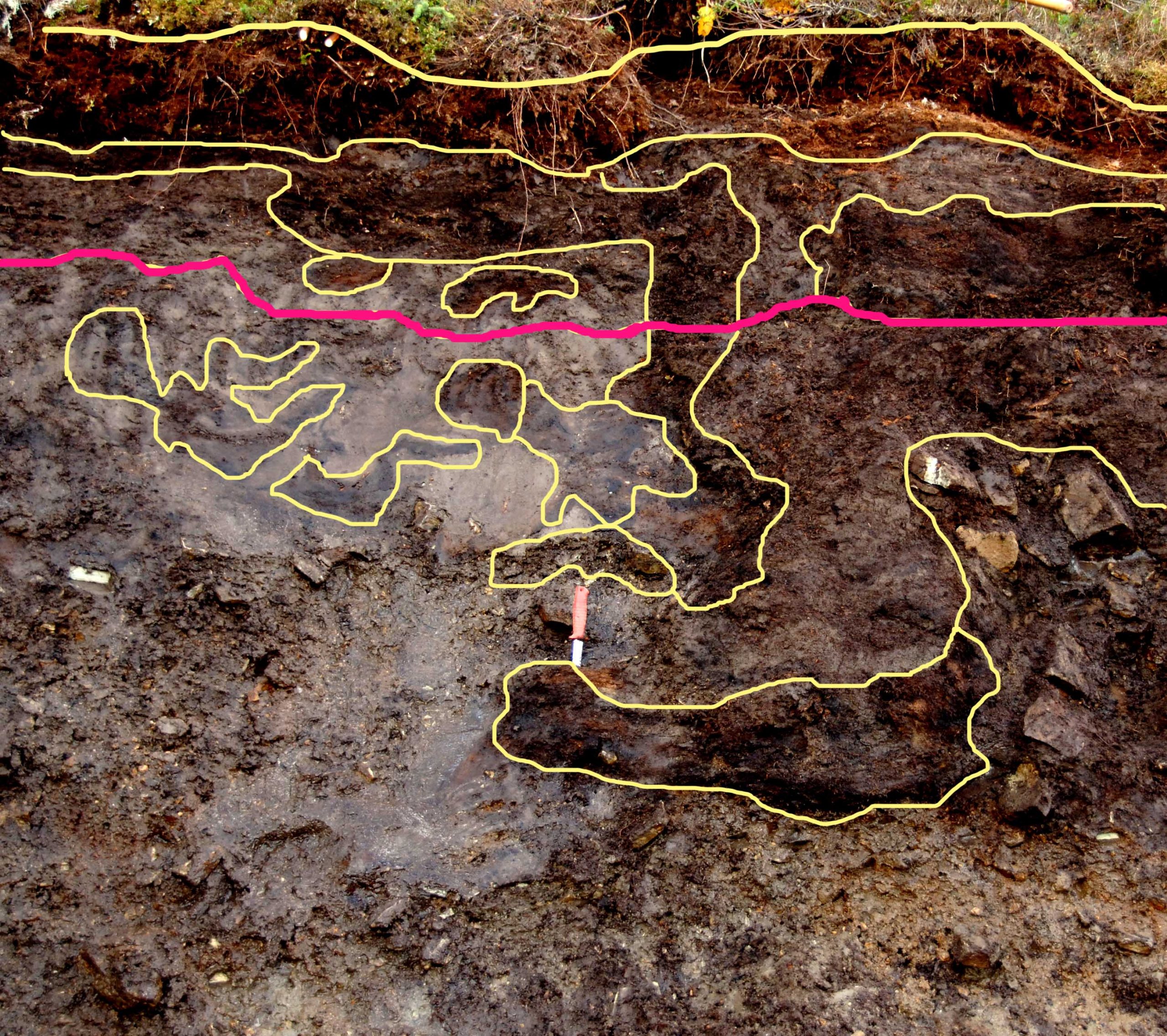
Paleosols are also found where land surface instability during the Holocene has lead to burial of land surfaces and the soils that formed on them. Buried paleosols can be found throughout Canada in fluvial and eolian deposits . They are also common in colluvial sediments (Figure 2.6), especially in mountain areas and in colluvial layers in sloping landscapes in the grasslands of the Prairie Ecoregion.
Can You Dig It!
Where’s the oldest soil in Canada?
The overwhelming majority of soils in Canada are (by global standards) very young since they have formed since the retreat of the great ice sheets began about 17,000 years ago. A few locations, however, emerged from the ice sheets much earlier than others and some points escaped glaciation altogether. The Yukon paleosol shown in Figure 2.4 formed on surfaces that were ice-free from about 200,000 years ago to the present day. The Cypress Hills paleosol in Figure 2.5 may be even older – these soils are found on a 300 km2 plateau in southwestern Saskatchewan and southeastern Alberta that was not overridden by glaciers at any point during the great ice ages. Some high-elevation buttes in southwestern Alberta also have very old soils – the soils and paleosols at Mokowan Butte in south-western Alberta have been extensively studied and the youngest soil here developed between 500,000 and 65,000 years old. The oldest paleosol at Mokowan Butte dates back to before 720,000 years ago. In his 2016 paper on the imprint of time on Canadian soils, Paul Sanborn notes that a large area in western and northern Yukon was never glaciated and presumably holds an array of very old soils but that most of the area remains to be explored by pedologists.
OVERVIEW OF SOIL-FORMING PROCESSES
The study of soil formation and classification is called Soil Genesis or Pedology.
Specific groups or classes of soils result from the action and interaction of the environmental conditions, and that these soil horizons will differ from place to place within a field and within a region or country. Hence, the distribution of soil horizons and soil properties is not random – they are responding to a set of environmental controls. The classification of soils in Canada is covered in Chapter 8.
Soil formation begins when freshly exposed sediments or rocks at the surface of the earth begin to be altered by various organic, chemical, and physical processes. Initially the alterations caused by these soil-forming agents are very slight, but through time they significantly alter the nature of the original materials. In some cases the minerals themselves are altered to new forms but in almost every case the physical organization (or structure) of the materials, both mineral and organic, is changed by soil formation. Soil formation creates new soil structural units ranging from small granules to large clods of soil, and these structural units are critical for air and water movement in the soil (soil physics reference).
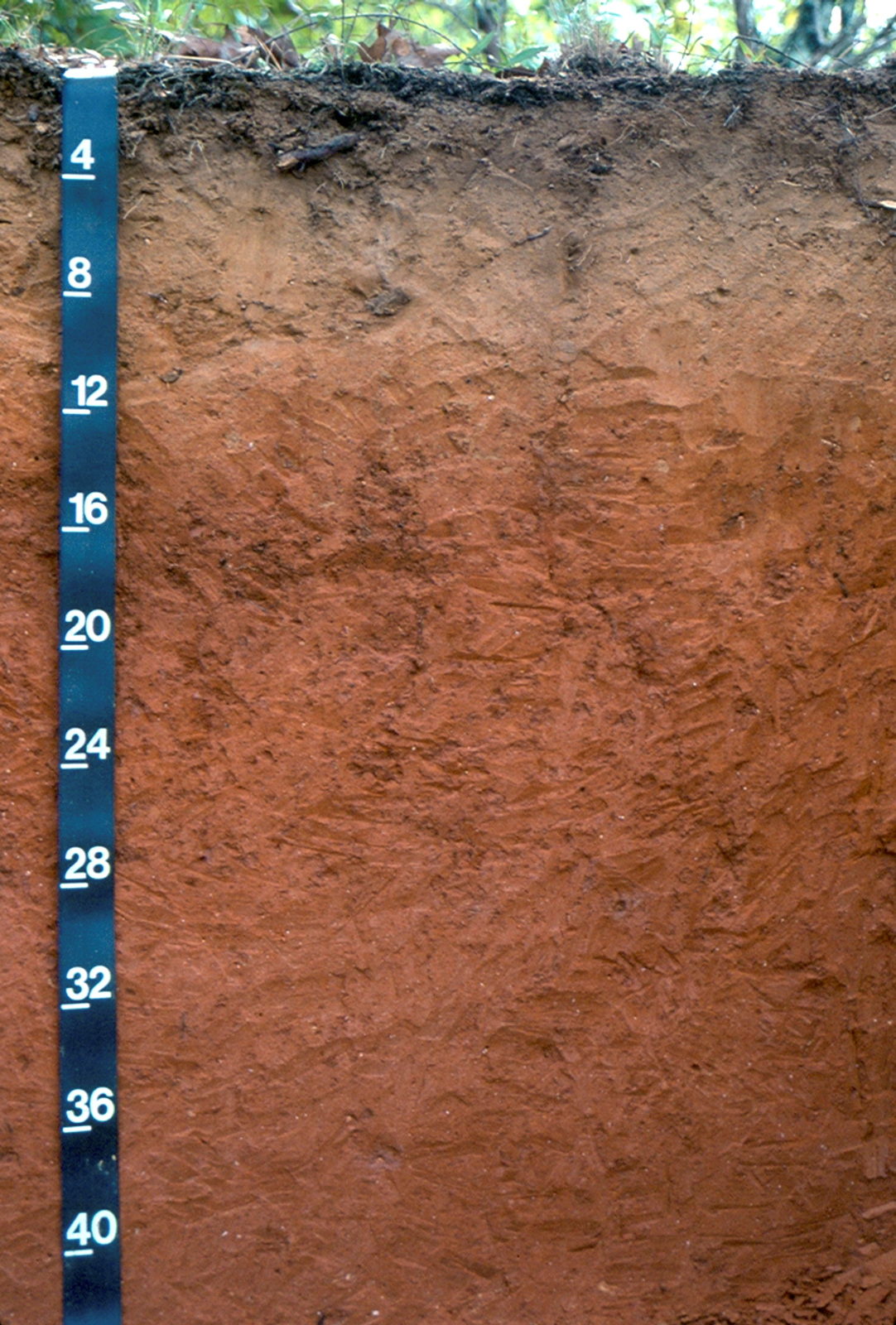
For many (but not all) soils in Canada horizontal layers that parallel the land surface begin to develop in the soil (Figure 2.7). These layers have distinct sets of soil forming processes associated with them, and are called horizons by soil scientists. The set of horizons exposed when a soil pit is dug is called the soil profile. The most readily recognized horizons are those with layers that have contrasting colours due to the action of soil-forming processes, but in other soils the differences between horizons are more subtle. In some Canadian soils the processes act to mix the soil material and hence distinct horizons do not form but these soils are far less common than those with distinct horizons. As we will see in Chapter 8 different horizons are assigned letters in classification systems such as the Canadian System of Soil Classification. In this chapter we will refer to them more generically according to how they are formed rather than the formal conventions of the classification system.
The soil-forming processes that create soils are bundled into four major groups (Figures 2.8 and 2.9): additions, losses, transfers, and transformations. The Virtual Soil Processes Project (Krzic et al. 2008) has an excellent overview video and website for the four soil processes.
Early microbial colonizers add carbon and nitrogen to a developing soil, largely at or very near the soil surface. As plants begin to colonize, addition of organic matter (OM) occurs both at the soil surface (when above-ground OM such as leaves and branches fall to the soil surface) and within the upper part of the soil (from below-ground OM such as roots and soil organisms of all sizes). Additions of water (and the ions and chemical compounds within the water, termed solutes) occur from precipitation falling on the surface, within the soil as laterally flowing soil water, and from groundwater moving from depth to the soil surface (Figure 2.8). Finally soil from elsewhere that has been eroded by water, wind, or tillage erosion can be deposited on the soil surface.
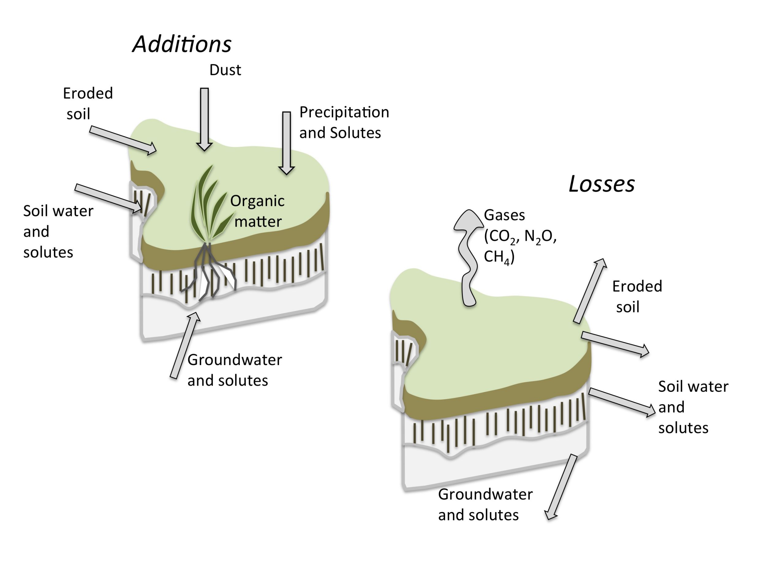
A significant fraction of the OM added to soils is lost as gases (especially carbon dioxide [CO2]) back to the atmosphere after decomposition of the organic material by soil organisms (Figure 2.8). Other losses include water and solutes lost through water flow within the soil and from the soil to the groundwater. The complete loss of solutes from the profile is termed leaching. As well as dissolved mineral ions, very fine OM can be leached from the soil into the underlying materials. Finally, in some situations soil is lost from the soil surface by water, wind, and tillage erosion.
Transfers are processes that occur within the soil rather than between parts of the landscape (Figure 2.9). In soil genesis we distinguish between transfer processes that remove material from a horizon (termed eluviation processes) and those that lead to gain of material in a horizon via deposition (termed illuviation processes).
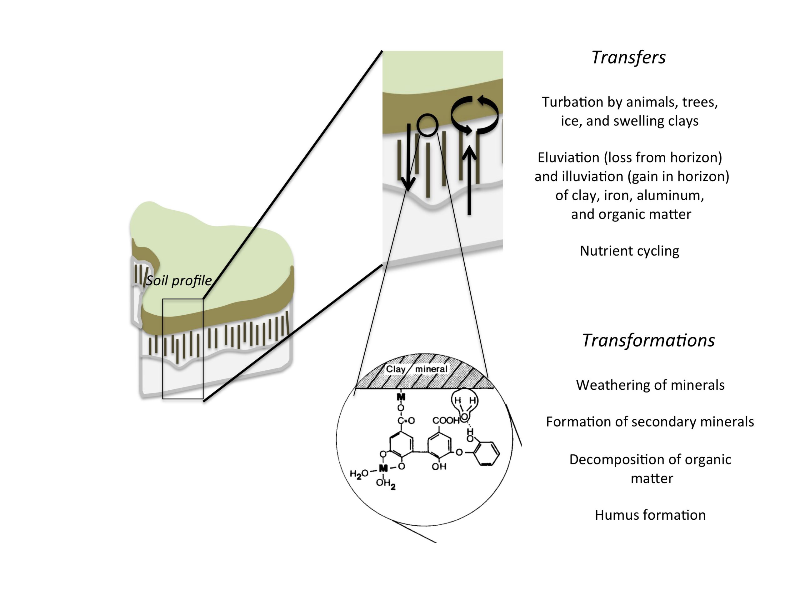
Transfers of solutes and solid particles occur as soil water flows between different layers of the soil. Very fine clay particles can be removed from upper soil layers and deposited deeper in the soil. In some soils, complexes between iron and aluminum and OM form and are also transported vertically within the soil and deposited at depth. Other transfers follow an initial stage of transformation, where (for example) ions are released from a mineral in an upper soil layer. In some cases, these ions are completely lost from the soil (in the process of leaching) but in others reformation of new minerals (called secondary soil minerals) occurs deeper in the soil.
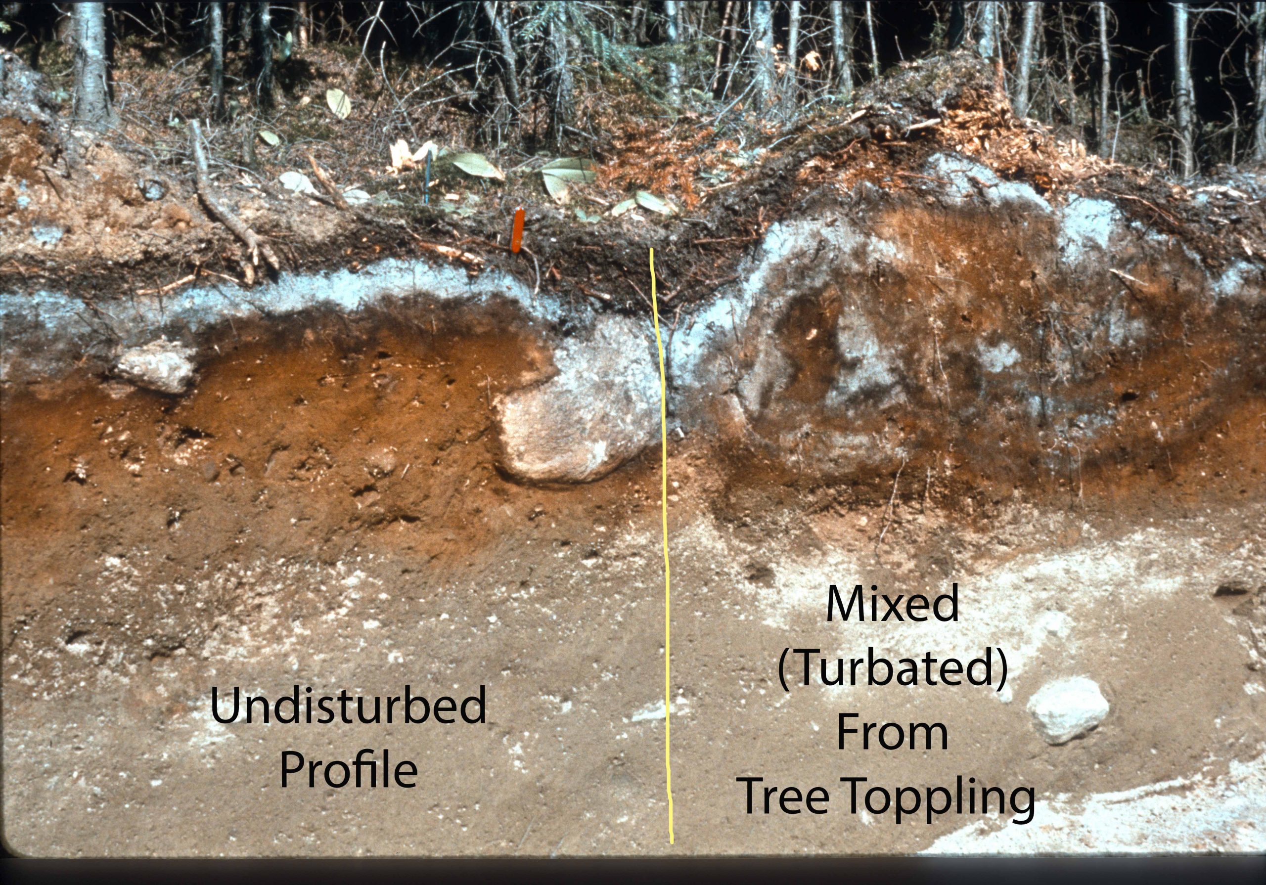
Mixing (also called turbation) between layers of the soil is another type of transfer and occurs due to both organic and physical agents. Many soil organisms such as earthworms and mammals that reside in the soil physically displace soil from one location to another, as do processes such as the toppling of trees in the forest (Figure 2.10). Mixing also occurs through physical processes such as the shrinking and swelling of certain clay minerals and the freezing and thawing that occurs in almost all Canadian soils.
Transformations of mineral and organic materials within the soil are very important for both soil genesis and for plant nutrition (Figure 2.9). The release of ions from minerals or the complete transformation of mineral particles from their initial form to new, secondary minerals is generally called weathering. Weathering can occur from physical processes such as freezing and thawing of soils or from chemical processes as discussed below.
There is a very complex set of pathways by which fresh OM added to the soil is transformed by soil micro- and macro-organisms into a range of new products, which is generally termed decomposition (see section SOM). In well-drained soils (i.e., where the soil pore space is normally filled with air), decomposition creates highly transformed, reactive organic complexes called humus. In poorly drained conditions (i.e., where the pore space is often or completely water filled) decomposition is retarded or absent, and organic materials instead accumulate and create layers of peat.
WEATHERING
Weathering is an umbrella term that refers to both the chemical alteration of soil minerals and physical disruption of minerals, which leads to smaller sized soil particles. Physical weathering in Canadian soils is limited due to their relative youth; hence, the size of soil mineral particles is inherited from the parent materials
The dominant control of chemical weathering is the hydrogen-ion concentration of the soil water in contact with minerals, leading to the rupture of chemical bounds via a process called hydrolysis. The small size of the hydrogen ion allows it to penetrate the mineral structure and to displace much larger cations from their positions within the mineral structure. Generally, the smaller the ionic charge (valence) of the cation, the more readily it is displaced during hydrolysis: sodium (Na+) and potassium (K+) are the most readily displaced, followed by divalent ions (Ca2+, Mg2+, Fe2+), and trivalent ions (Fe3+, Al3+) and Si4+ (Table 2.3). Heavily weathered tropical soils are dominated by aluminum and iron, and the iron gives them a deep red colour.
Table 2.3. Composition of average igneous rocks and three surface soils of increased weathering: temperate forest soils are the least weathered and tropical forested soils the most weathered. All values reported as percentages. Adapted from H.L. Bohn et al. (1979). Soil Chemistry. John Wiley and Sons, New York.
| Element | Average Igneous Rock | Temperate | Sub-Tropical | Tropical |
|---|---|---|---|---|
| Forested soil | Forested soil | Forested soil | ||
| SiO2 | 60 | 77 | 80 | 26 |
| Al2O3 | 16 | 13 | 13 | 49 |
| Fe2O3 | 7 | 4 | 5 | 20 |
| TiO2 | 1 | 0.6 | 1 | 3 |
| MnO | 0.1 | 0.2 | 0.3 | 0.4 |
| CaO | 5 | 2 | 0.2 | 0.3 |
| MgO | 4 | 1 | 0.1 | 0.7 |
| K2O | 3 | 2 | 0.6 | 0.1 |
| Na2O | 4 | 1 | 0.2 | 0.3 |
| P2O5 | 0.3 | 0.2 | 0.2 | 0.4 |
| SO3 | 0.1 | 0.1 | 0.1 | 0.3 |
The main source of hydrogen is the reaction between gaseous carbon dioxide and water to produce carbonic acid (H2CO3), which ionizes to form bicarbonate (HCO3–) and hydrogen ions (discussed in more detail in Pennock et al., 2010). Hydrogen ions are also produced by various organic acids that form during the decomposition of organic materials. See Chapter 5 for further information on soil reaction and pH.
The hydrogen ions act in distinct ways upon different classes of minerals. Silicate minerals dominate the mineral fraction of sediments formed from igneous rocks. The basic building block of silicate minerals is formed by a silica cation surrounded by four oxygen anions (reference to section on clay minerals). The various classes of silicates are caused by the inclusion of other ions along with the basic silica-oxygen units. An important class of silicates are those that have a layer structure (i.e., phyllosilicates) that form in the near-surface zone of the earth’s crust at much lower pressures and temperatures than many other silicate minerals. This class of minerals is generally called the clay minerals, which is somewhat unfortunate since clay also refers to a size range of mineral particles as well.
Silicate minerals high in easily displaced cations (e.g., Na+ and K+) experience collapse of their structure after cation displacement and the mineral disintegrates. At the other extreme, quartz is composed solely of silica and oxygen and is the most resistant silicate mineral to weathering; indeed many of the most highly weathered landscapes in the world are dominated by sand-sized quartz minerals (Paton et al., 1996). Hence, under most conditions in Canada, quartz is little affected by weathering processes. Weathering of clay minerals in Canadian soils is largely restricted to acidic Podzolic soils where transformations and losses of clay minerals through weathering in the bleached surface horizon occurs (Kodama, 1979).
Sediments formed from sedimentary rocks contain high contents of mineral carbonates and more soluble salts along with silicate minerals. The most important in the Canadian context are carbonates and more soluble salts formed through precipitation of ions in ancient seas and lakes. Compared to silicate minerals carbonates and salts are readily dissolved in water (i.e., they are soluble); hence, they are readily weathered in the soil.
The final class of non-silicate minerals are oxides of aluminum and iron. Most metal oxides are weathering products from primary igneous silicates and are dominant in heavily weathered soils such as those in sub-tropical and tropical areas. Because almost all Canadian soils are relatively young (in geological terms), iron and aluminum oxides are less common in Canadian soils but are important in colour formation in acidic forest soils and water saturated soils.
Cations freed by mineral weathering are available to be taken up through plant uptake, moved by mobile soil water laterally or vertically, or react with other ions to form new, secondary minerals. Low valence cations such as sodium (Na+) are most readily released by weathering and are the most likely to remain in solution and hence be removed from soil in the process of leaching. Cations such as calcium (Ca2+) and magnesium (Mg2+) are released by weathering in the upper part of the soil but typically reform as secondary carbonate minerals lower in the soil. The higher valence ions (Fe3+ and Al3+) are the most likely to remain in place and form new secondary soil minerals. These secondary minerals dominate older, more heavily weathered soils outside of Canada.
Role of water and organisms in chemical transformation of soil materials
Carbonic acid (an important driver of hydrolysis in soils) results from the initial reaction of water and carbon dioxide. Generally, the higher the availability of both water and carbon dioxide, the greater the amount of hydrolysis and hence weathering of soil minerals that will occur. Plants and organisms that live in the soil contribute to hydrolysis by raising the CO2 concentration in the topsoil by 10 to 100 times atmospheric levels, thereby increasing H+ concentration. Generally, mineral weathering will be greatest where the availability of water and carbon dioxide is greatest; for example, in the coastal rainforest of British Columbia. The least weathering will occur where both water and CO2 are the most limited, such as very dry, cold soils of the high Arctic.
Organisms also accelerate weathering through the process of chelation where certain organic molecules caused by decomposition form complexes with mineral cations (especially relatively immobile ions such as iron and aluminum) and extract them from mineral structures. These mineral-organic complexes can then be moved through the upper soil and deposited deeper in the soil profile. Lichens are very active in the promotion of chelation, and they are typically early colonizers of soil surfaces.
MAJOR SOIL FORMATION PATHWAYS IN CANADA
Thus far, we have seen that shape of the landscape and the parent materials that soils form in were largely inherited from glacial and post-glacial geomorphic processes. These parent materials are then transformed through weathering, which is closely linked with organisms and the availability of water.
Although soil water availability and organisms are the main controls on national-level soil formation, the temperature plays an important secondary role. Most all Canadian soils experience periods of freezing and thawing every winter, and frost action is an important physical control on soil formation. The role of freezing and thawing is best expressed in the soils of Taiga and Arctic ecozones typical of northern Canada, where frost action is indeed the dominant control on soil formation. In more temperate regions, temperature also controls, in part, the rate at which microorganisms decompose organic materials and the type of decomposition product produced, leading to distinctive soil horizons in forested soils.
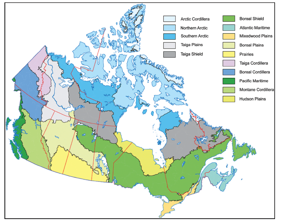
At the national level, the regional patterns of moisture availability and temperature give rise to characteristic assemblages of vegetation and animals and these have been classified into distinct ecozones (Figure 2.11). These ecozones have characteristic bundles of soil-forming processes associated with them, and soils in these ecozones follow distinct pathways of soil formation. Forests, grasslands, and tundra ecozones all have distinct surface soil layers associated with them due to the interplay between their characteristic plants and the extraordinary range of organisms that dwell in the soil.
Forest Soils
In forested biomes the great majority of fresh OM is added to the soil surface in the form of fallen leaves, branches, and dead trees themselves. The freshly added OM undergoes decomposition by soil animals and microorganisms and typically the organic mat on the soil surface is layered, with fresh OM on the top and highly decomposed material directly overlying the mineral soil surface. The degree of decomposition depends on the water available, the temperature, and the nature of the OM added to the surface.
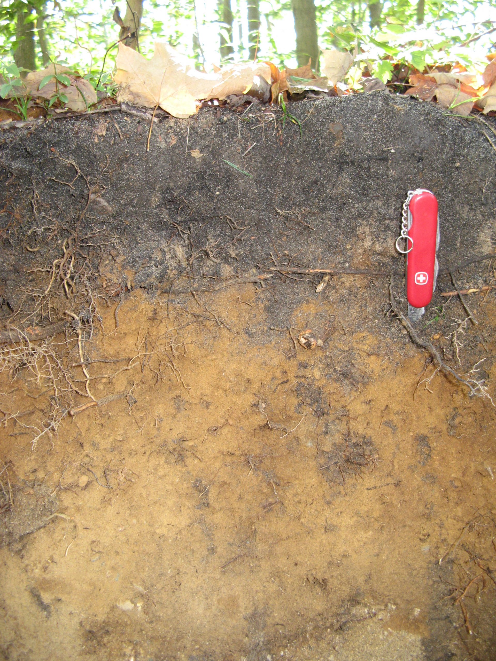
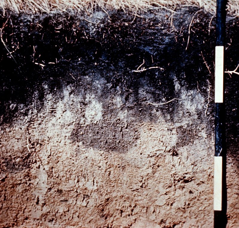
For most forested biomes in Canada the OM is not incorporated into the mineral layer underneath and there is a sharp contact between the two. Mixing of the two layers does not occur because there are no soil-dwelling organisms (such as earthworms or small mammals) that cause mixing to occur. Earthworms were eliminated from soils in northern North America by the great ice sheets and they are only slowly recolonizing the southern parts of Canada. Small mammals that live part of their lives within the soil are also largely absent from forested sites (Zaitlin and Hayashi, 2012). In areas of Canada where earthworms have invaded forested sites (such as Southern Ontario and Quebec), the OM becomes incorporated into the surface mineral layer and a mixed organic-mineral surface layer occurs (informally called mull by soil scientists) (Figure 2.12) . Where earthworms are absent, the organic mat instead forms a sharp and distinct contact with the mineral layer; litter layers of this type are informally called mor (Figure 2.13). Moder is a form of organic layer intermediate between mor and mull. An excellent on-line resource to distinguish among these three forms is at the Virtual Soil Science Learning Resources forest floor website.
The nature of the parent materials (i.e., sediments derived from igneous rocks versus those from sedimentary rocks) strongly controls the soil genetic pathways of forested biomes. Glacial sediments derived from igneous rocks are generally dominated by quartz sand and sand-sized silicate minerals and salts and carbonates are absent. Hence, these soils have little inherent ability to neutralize hydrolysis by hydrogen ions in the soil water. The high hydrogen-ion levels (or acidity) is further augmented by the decomposition of organic materials, which releases organic acids from the OM.
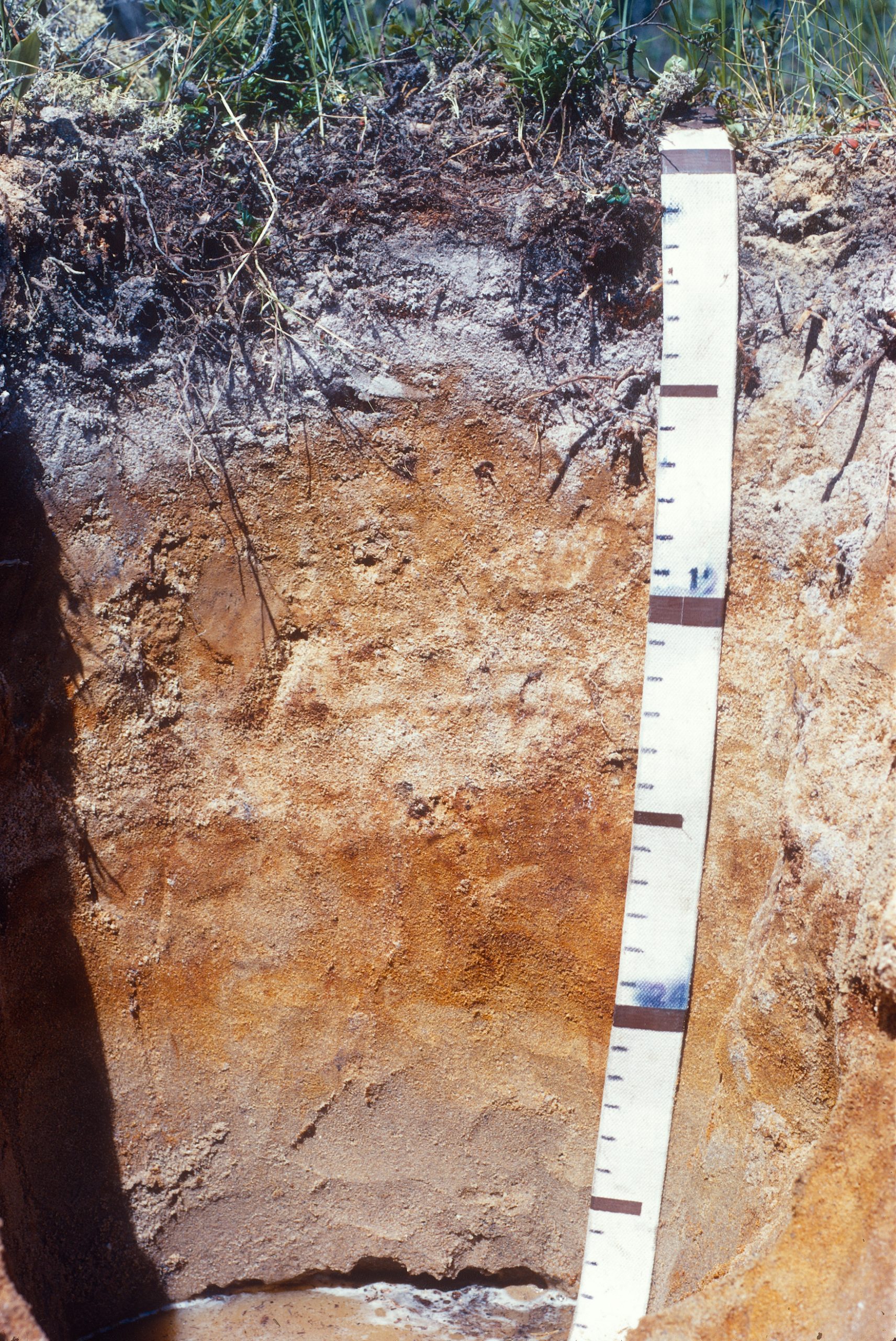
The reaction between the acids in soil water and the sandy surface material produces a characteristic genetic pathway (Figure 2.14). Initially, the acids react with very fine iron particles, which form thin, reddish or red-brown skins on the resistant quartz grains (Paton et al., 1996. p. 125). This causes an overall reddening of the upper part of the soil. In the second stage, the organic molecules produced by decomposition form complexes with the iron coatings and strip them from the quartz grains, causing bleaching of the uppermost layer of the soil. This bleached layer characteristically has grayish or grayish-white colours.
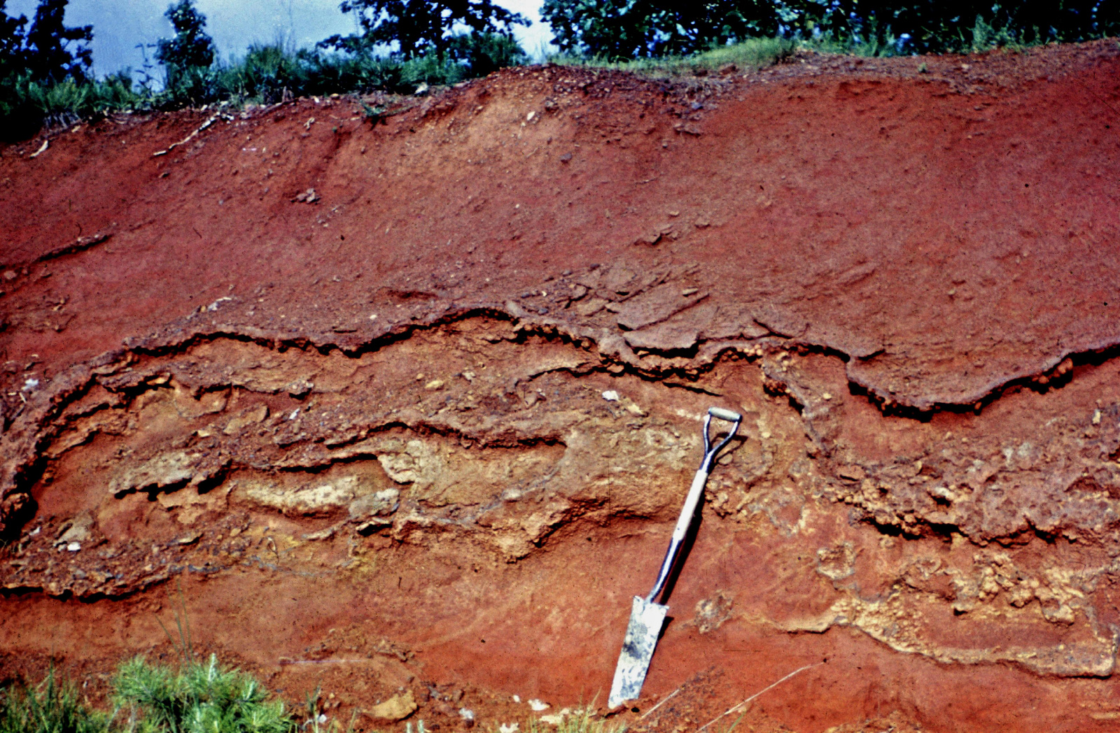
In the third stage, the iron-organic complexes are transferred deeper into the soil where they are deposited, creating a layer of concentrated organic compounds and iron (and, to a lesser extent, aluminum). These depositional layers have black or reddish colours, and the colour contrast with the overlying bleached layer is very striking (Figure 2.14). The process of the formation of organic-mineral complexes in the upper soil and their transfer and deposition in the underlying soil is called podzolization (Sanborn et al., 2010, p. 857-866). The upper layer, where iron is lost from the quartz grains, is an example of an eluvial horizon; the underlying layer, where the organic-mineral horizons are added, in an illuvial horizon.
The genetic pathway is very different for soils formed in sediments derived from sedimentary rocks. These sediments are typically rich in carbonates such as calcium carbonate (CaCO3) and have loamy textures (i.e., a mixture of sand, silt, and clay). Initially the carbonates are found throughout the soil profile and act to neutralize (or buffer) the acids produced by organic decomposition. This neutralization process gradually destroys the carbonate minerals and a layer of carbonate-free material forms at the soil surface and thickens with time. The calcium ions released by weathering are transported to depth in the soil profile where they re-form into new, secondary calcium carbonate minerals (Figure 2.15). The loss of calcium from the upper soil is termed decalcification and the gain of newly formed calcium carbonate at depth is called calcification.
The loss of calcium carbonate from the upper soil creates a more acidic soil chemical environment in the upper soil that allows very fine clay-sized particles to be released into the soil water and transported to the underlying soil layer, where they are deposited. This process of clay transfer (called lessivage) creates layers with contrasting textures – lower clay content in the upper eluvial layer and higher clay content in the illuvial layer (Figure 2.16) (Lavkulich and Arocena, 2011). These texture-contrast layers can also occur due to layering of sediments during the glacial or Holocene periods – for example, when a wind-borne silt is deposited over an underlying loamy till. Soil scientists call these layered horizons lithological discontinuities. There is no field-based method to distinguish between texture-contrast horizons caused by lessivage and those due to lithological discontinuities and indeed lessivage may well occur in a profile with a lithological discontinuity.
Forested biomes also contain many sites where water ponds and wetlands form. The genetic pathways of these wet soils differs greatly from the better drained forest locations discussed above and are discussed separately below.
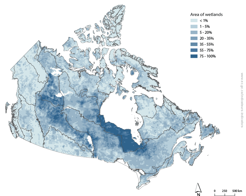
Wetland Soils
Wetlands are a common feature of the Canadian landscape (Figure 2.17). Globally one of the largest extents of wetlands is found in the Hudson Plain ecozone south of Hudson Bay. Wetlands are also very common at the contact between the plains of western Canada and the Canadian Shield – many northward flowing rivers from the plains are unable to carve channels through the resistant igneous rocks of the Shield and water ponds at the contact. There are also countless small wetlands distributed throughout almost every landscape in Canada due to local-scale topographical unevenness.
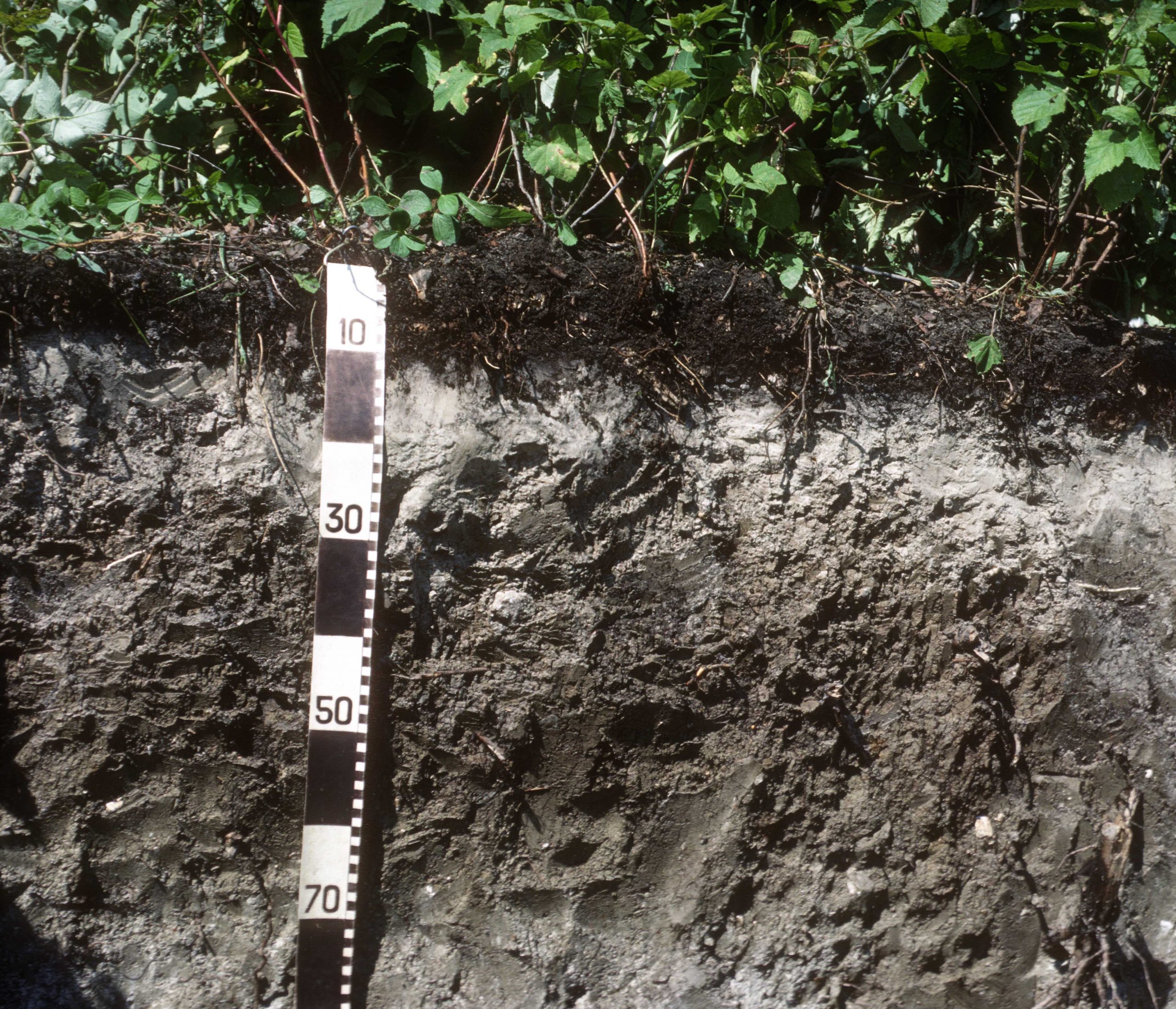
The presence of prolonged periods of water saturation in the soil profile fundamentally alters the pathway of both OM decomposition and mineral weathering (Bedard-Haughn, 2011, p. 768-773). Microorganisms decompose organic material to feed off the nutrients and energy contained within the OM. The energy (in the form of electrons) that is liberated during decomposition must be taken up by other ions or organic compounds or else decomposition is unable to proceed. In soil with oxygen in the soil pore space (called aerobic conditions), oxygen itself takes up the electrons and decomposition continues until only highly resistant organic compounds are left. Where water displaces oxygen in the pore space (called anaerobic conditions) alternative electron acceptors must be used instead. The most common mineral electron acceptor is iron (Fe). In aerobic soils Fe occurs as Fe3+and is responsible for the reddish colours found in soils. In anaerobic conditions the Fe3+ ion accepts an electron and its charge is reduced to Fe2+. This form of iron is mobile and can be transferred within the soil, and the loss of iron creates dull soil colours, often with a bluish-grey hue. If a soil becomes partially or wholly aerobic (when water drains out of the soil column) some of the reduced iron may re-oxidize to a reddish state, giving the soil overall a mottled appearance (Figure 2.18). The complex processes associated with these chemical state transformations are called redox (reduction-oxidation) processes, and in soil science are referred to as gleying. See the Oxidation-Reduction (Redox) Processes section in Chapter 5 for more information on these processes.
In soils with prolonged water saturation all mineral electron acceptors may ultimately be used up and organic decomposition essentially ceases. A largely undecomposed organic mat (called peat) begins to build up from the mineral soil surface and can reach up to several meters in thickness (Tarnocai, 1990; Kroetsch et al., 2011, p. 814-816) (Figure 2.19). The very slow decomposition processes produce methane (CH4), which is an important greenhouse gas. Often the organic mat will contain layers with different degrees of decomposition, ranging from almost entirely undecomposed material (called fibric material), partially unrecognizable material (mesic), through to largely unrecognizable material (humic material). In some cases the organic material is mixed with mineral particles, creating muck soils.
In northern Canada, accumulation of organic material is very common due to the low evapotranspiration rates and the natural conversion of forests into wetlands is widespread. Ultimately, Sphagnum mosses become the dominant vegetation on the landscape and thick organic mats can occur. This process of organic soil development is termed paludification.
In more southerly locations (such as the Prairie and Mixedwood Plains ecozones), the warmer temperatures and hence higher decomposition rates prevent the formation of thick organic mats. Wetland soils in these locations are instead typically mineral soils with soil colours (dull colours, mottling) reflecting the gley conditions.
A final type of thick organic deposit is associated with wet conditions (typically 3000-4000 mm of precipitation per year) in the coastal rainforest of the Pacific Maritime ecozone of British Columbia. The lush coastal rainforest produces large amounts of organic material and the high rainfall levels retard decomposition, leading to a thick buildup of forest-derived organic materials (called folic materials) (Fox and Tarnocai, 2011, p. 828-234).
Tundra and Arctic Cordillera Soils
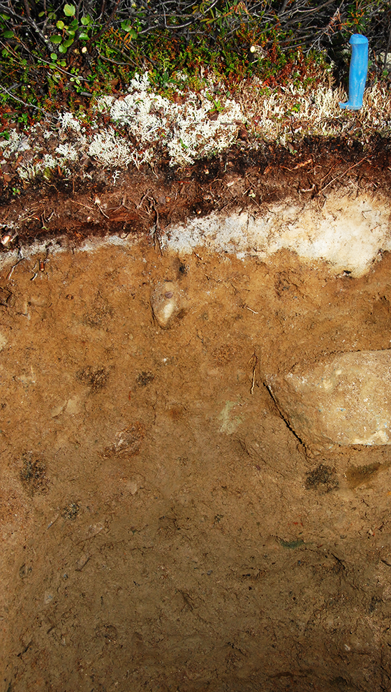
In the cold climate of the Canadian Arctic, the soil-forming processes discussed above (for example, organic matter decomposition, transformations of minerals) are still present but they occur at very slow rates due to the low annual temperatures and short frost-free period. Soils in these regions have permanently frozen layers (called permafrost) within them and any water in these layers is frozen. The presence of ice leads to unique soil-forming processes, which are generally termed cryogenic processes.
The main cryogenic process affecting soil properties is mixing (or cryoturbation) caused by the growth of ice lenses in the soil (Tarnocai and Bockheim, 2011, p. 750-757). When ice forms in the soil it draws unfrozen soil water along a thermal gradient to the ice front. This causes the lens of ice to grow and displace mineral and organic soil material, mixing together the soil at the ice-water interface (Figure 2.20). This mixing is more pronounced in the surface layer of the soil, which undergoes seasonal thawing and freezing and is called the active layer. The pressure exerted by the ice also causes sorting of coarse rock fragments in the soil and the occurrence of unique features such as stone circles and polygons, earth hummocks, and ice wedge polygons. Turbation is most pronounced in loamy and fine-textured soils, and although permafrost occurs in coarse-textured sand and gravel soils the soils often show little or no evidence of cryoturbation.
At the southern boundary of the tundra in the Taiga ecological region, permafrost becomes discontinuous in the landscape, with patches of permafrost in lower-lying landscape positions and non-permafrost soils in uplands. Because of the dependence of permafrost on prolonged freezing conditions these transitional areas are very likely to be affected by increasing temperatures due to human-induced global warming.
Similar conditions occur at high elevations in the western Cordillera and permafrost soils also occur in the Alpine tundra. The Alpine tundra can be home to burrowing mammals and a turbated surface layer high in organic matter often occurs.
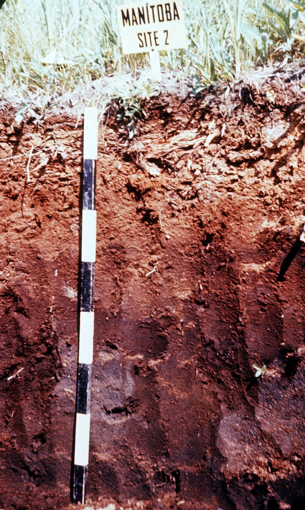
Grassland Soils
The greatest extent of grasslands (or at least former grasslands, as much of this area has been cultivated) in Canada is the Prairies ecozone. The Prairies ecozone is underlain by sedimentary rocks dominated by clay-rich marine shales and limestone and hence the glacial and Holocene sediments found in the region are normally high in carbonates and (in places) other more soluble salts. The landforms of the Prairies are dominantly formed by glacial deposition and include extensive areas of moraine, glacio-fluvial sands, and glacio-lacustrine silts and clays (Figure 2.2). Eighty-one percent of Canada’s agricultural land is located in the three Prairie provinces (160 Mha in total; 62 Mha in Saskatchewan, 51 Mha in Alberta, and 18 Mha in Manitoba; Census 2011).
Two groups of soil-forming processes dominate this region: (1) below-ground OM additions from grasses (i.e., fibrous roots) and subsequent mixing by animals and (2) weathering of carbonates and salts and their transport through the soil and landscape (Pennock et al., 2011, p. 725-732). There are also two additional genetic pathways that are found in specific areas, one associated with physical mixing due to high clay contents, and the other due to the effect of high soil sodium (Na+) levels on soil formation.
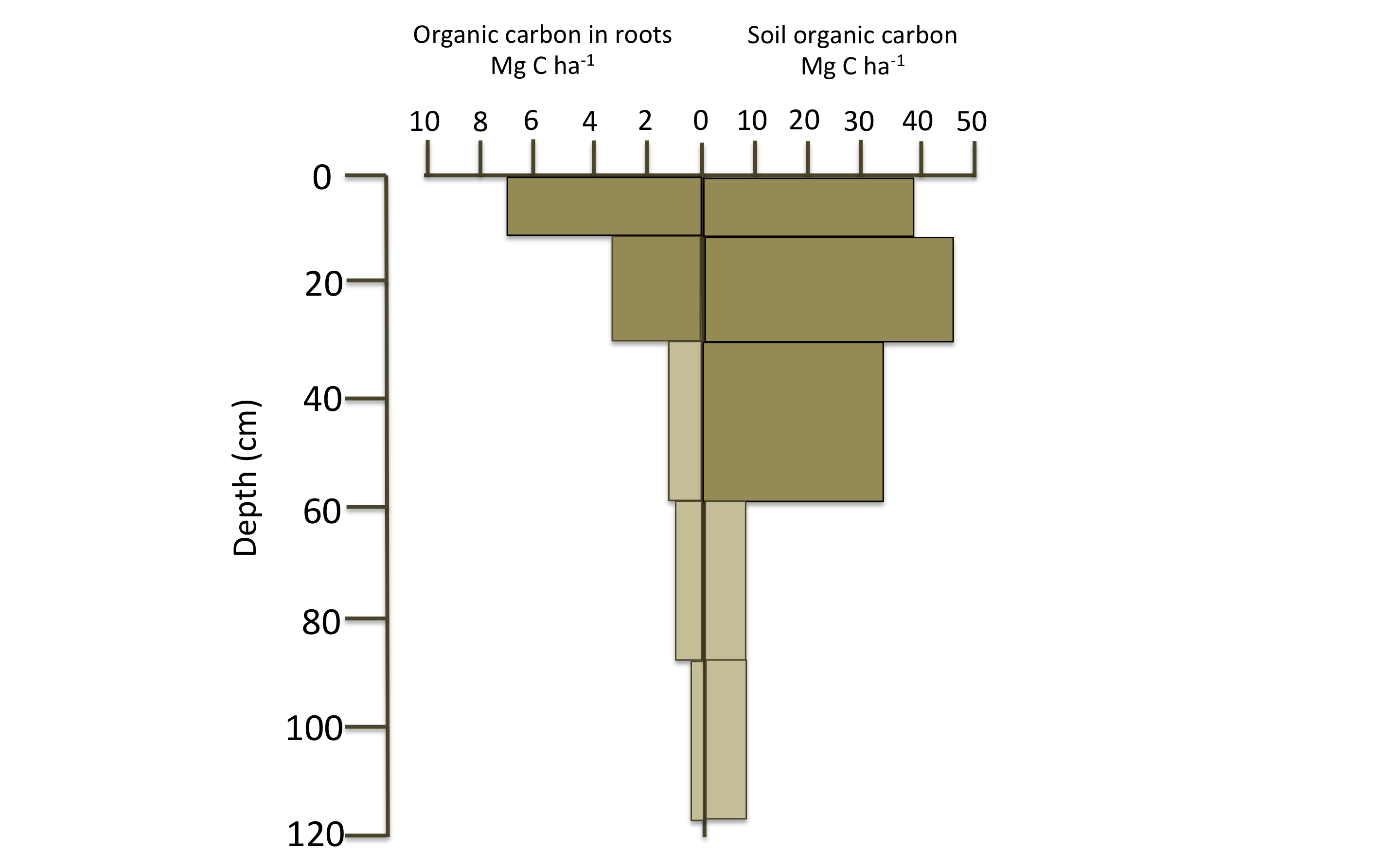
The majority of biomass in grasses is situated below-ground in their extensive root systems, which reflects the need for the grasses to fully exploit the soil for water in this region of significant water deficit. In the example shown in Figure 2.21 (Slobodian et al., 2002) the aboveground parts of the grasses had a biomass of 1,060 g m-2, compared with 2,532 g m-2 belowground in the root systems. As roots age and die they are transformed by microorganisms through a complex set of processes into resistant humus, which can be stored for hundreds of years in the soil. The storage of soil organic carbon (SOC) is several times that of the living root material in the soil (Figure 2.21).
The belowground OM inputs into the upper soil are then turbated by the action of soil-dwelling mammals (such as ants, ground squirrels, badgers, moles) and normally the organically-enriched upper soil is more mixed and extends more deeply than the root layers themselves (Figure 2.21). Often the evidence of burrowing animals in the form of infilled burrows is evident in these grassland soils (Figure 2.22).
Decomposition of the root biomass also leads to high levels of CO2 gas in the upper soil, also contributing to the destruction of salts and carbonates by chemical hydrolysis. As discussed above, the salts such as halite are readily weathered and release cations such as Na+ into the soil solution, where it can be leached from the soil into the groundwater. The main carbonate mineral CaCO3 is more slowly dissolved in the upper part of the soil column and the Ca2+ ion is transferred deeper into the soil, where it typically precipitates out of solution and reforms secondary calcium carbonate minerals. Therefore the grassland soils normally have an area of carbonate depletion in the upper soil and carbonate concentration lower in the soil profile.
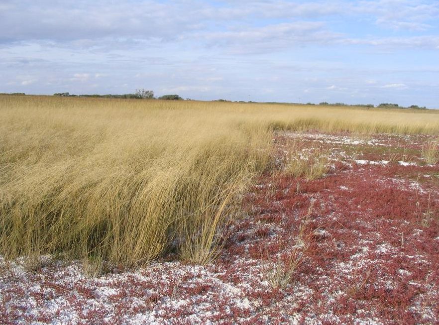
The more mobile sodium ions are transported through the groundwater system for distances ranging from a few hundred meters to many kilometers. Ultimately the groundwater flow system can lead to them being brought back to the soil surface (termed groundwater discharge) (Chapter 4). Continued evapotranspiration of the discharging groundwater can lead to increasing levels of soil salts through time (termed salinization) and these high salts levels can be injurious to plant growth (Figure 2.23).
Sodium is also responsible for a distinct set of soil-forming processes typical of areas where sodium-rich bedrock occurs close to the soil surface or where sodium-rich groundwater reaches the soil surface (Acton, 1990; Miller and Brierley, 2011). When sodium binds to reactive clay particles it causes the clay to be released from the mass of soil into the soil pore water (Chapter 5) and the sodium-saturated clay is subject to transport from the surface layer to lower layers in the soil. This process (called solonization) leads to formation of a clay-enriched, high-sodium layer deeper in the soil. Once this layer has formed it can lead to pronounced mineral weathering and bleaching of the overlying layer and creation of a distinct eluvial, gray-coloured horizon; this process is called solodization (Figure 2.24). See the section on Salinity and Sodicity in Chapter 5 for more information on these processes.
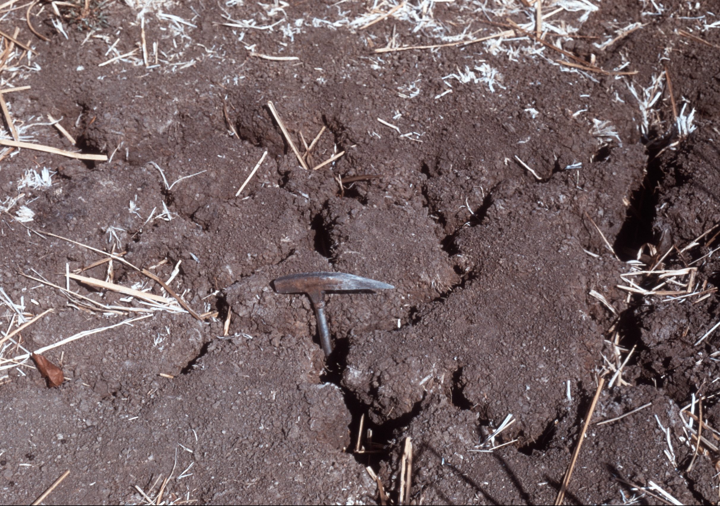
A final distinctive soil-forming process associated with grasslands is physical mixing of soil caused by the shrinking and swelling of some clay minerals (Brierley et al., 2011). Many locations in the Prairies have glacial-lacustrine sediments with high smectite clay contents. The smectite clays originate in the marine shale bedrock found throughout the Prairie region. These clay minerals can absorb water (and swell) when the soil is saturated and release water (and shrink) when the soil is dry. This physical process causes cracking of the soil (Figure 2.25) when the soil is dry and turbation (sometimes referred to as argillipedoturbation or self-mulching) of the soil when the soil is wet, leading to inversion of soil material. The turbation mixes together the surface soil material and prevents the formation of distinct soil horizons with clear boundaries with adjacent horizons. This set of processes are called vertic processes.
The grasslands also have countless wetlands associated with them and these wetlands are important habitats for migratory birds. The wetlands in the Prairie ecozone periodically dry out; hence, OM deposits do not form; instead they are dominated by mineral soils showing gleyed features (dull colours, mottling).
Formation of Soil Structure
As discussed in Chapter 4, the structure of the soil plays a very important role in formation of pores that consequently impact air, gas, and water movement in the soil as well as the ability of roots to penetrate into the soil to extract water and nutrients. The initial structure of a soil is inherited from the parent sediments but many of the soil-forming processes discussed above lead to distinctive arrangements (called aggregates or peds) of mineral and organic materials and soil pores (Figure 2.26).
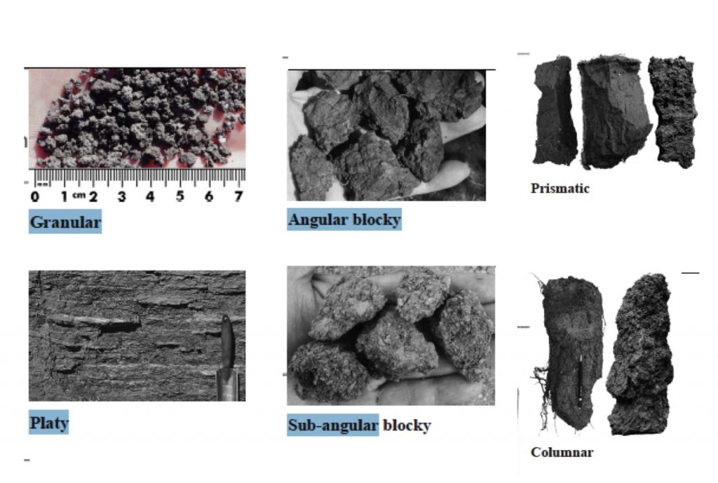
The key property of the parent sediment that influences the types of aggregates formed is the clay content. Clay particles are reactive (due to their small size and presence of charges on their surfaces) and can bond together into large and stable structural units. Soils dominated by sand-sized particles are largely non-reactive; hence, sandy soils have weakly developed and readily disrupted aggregates (if they are present at all).
Two sets of soil-forming processes modify the initial, sediment-derived structure. The first is the addition, transformation, and mixing of OM that occurs in grassland soils, tundra soils (due to small mammals), and in forest soils where earthworms have invaded the forests (such as in southern Ontario and Quebec). The dense root network of grasses acts as netting to bind solid soil material together and the larger soil organisms such as earthworms create soil aggregation by ingesting and excreting the soil material. The result of these agents is formation of a relatively loose granular aggregates (Figure 2.26), and such soil structire is well suited to root penetration and growth.
The second bundle of processes are the physical processes, especially those associated with freezing and thawing of soil water and swelling and shrinking of clay minerals. In some cases freezing and thawing in the bleached eluvial horizon in forest soils creates a horizontally layered platy structure (Figure 2.26). In loamy or clay-dominated soils the physical processes create a range of sizes and shapes of aggregates (Figure 2.26). In some cases (such as the high Na+ soils of grasslands), the structural units become so dense that they prevent root penetration and limit plant growth (clay-rich layer in Figure 2.25). Another example of growth-limiting structural units occurs in forested landscapes where deposition of iron-organic compounds and clay can clog soil pores and solidify into a near-solid mass. Depending on the type of cementing agent these features are called duric horizon or placic horizons.
Apparent structural units caused by human activity, such as cultivation, are referred to as clods, which do not cohere in the same manner as structural units that are naturally formed.
Human Activity as a Soil Forming Factor
So far in this chapter we have only considered soil formation under natural conditions but in many parts of Canada soils have also been transformed by human use. The impact of humans on soil formation has been most pronounced since settlement by Europeans began. Initially this impact was largely through conversion of land to agriculture and exploitation of forests but in the 19th and 20th Centuries the impact of mining and petroleum exploitation also became important. In the 20th Century the great expansion of urban areas has also profoundly affected the soil landscape.
The conversion of grassland and forested landscapes to agricultural production affects almost all of the processes that occur in soil. In terms of soil genesis the almost universal impact of agricultural conversion is a loss of SOM due to the combined effects of the breakup of aggregates and exposure of SOM to microbial decomposition and accelerated microbial decomposition and soil erosion (discussed below). Globally studies have shown that an average about 30% of the original soil organic carbon is lost when conversion from forest or grassland to cropland occurs (FAO, 2019). In forested sites with leaf litter lying on the surface, the clearance of trees and ploughing incorporates part of the leaf litter layer into the soil, resulting in an organically enriched mineral surface horizon.
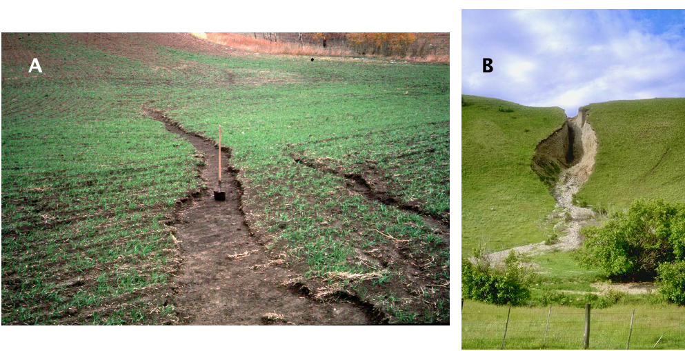
Clearing of the land surface also leads to increases in soil erosion by water, wind, and tillage. Soil erosion is the detachment and transport of soil from one position and its deposition elsewhere (FAO, 2019). Water erosion involves soil detachment and transport by water. Soil can be detached by both raindrop impact and by flowing water, and transport is by water flowing on the surface. Where water concentrates on the soil surface, channels can be incised into the surface, creating shallow rills (Figure 2.27A) or deeper gullies (Figure 2.27B). The eroded soil may be deposited within the field or at the field edge but in some cases it is carried directly to stream systems, where it causes many environmental problems.
In wind erosion the wind itself detaches and transports soil particles. Wind erosion can occur anywhere where the soil is dry and bare and the land surface is flat. The worst episodes of wind erosion in Canada occurred in the southern part of the Prairie ecozone in the 1930s (hence, the Dirty Thirties) and lead to widespread land abandonment and depopulation.
Tillage erosion is a more insidious type of erosion. Tillage operations by farm implements inexorably remove soil from upper slopes and deposits it in lower slope positions during farm operations, yet the effects of any one operation are almost undetectable (FAO, 2019).
In terms of soil formation the main effect of soil erosion is to remove part of the organically enriched surface soil. In tillage erosion the amount of soil removed in a year may be very small (0.5 to 1 mm) but the cumulative effect year-after-year can be substantial. In water erosion rills and gullies can remove part or all of the organically enriched layer, as can wind erosion during very severe events. This loss (or truncation) of the surface layer leads to a loss of the most fertile part of the soil for plant production. It may also bring a growth-limiting lower soil layer (for example, with high sodium levels) closer to the surface, further reducing plant growth. Where deposition of eroded soil occurs in lower slope positions, the upper soil layer becomes unnaturally over-thickened. These are termed cumulic soils (Figure 2.28). See Chapter 14 (Soil MIneralogy) for further information on the transformations of minerals by weathering.
Resource extraction and transport activities such as mining for minerals or for bitumen or pipeline development also fundamentally alter the soil, in some cases by completely excavating the soil and underlying sediment. Currently, regulations are placed to require some level of reconstruction of a soil but inevitably the constructed soil will differ from the original soil profile. Soils resulting with major disruption from human activities are termed anthropogenic (i.e., formed by humans).
A final (in every sense of the word) impact of humans on soil genesis is the complete stripping and/or burial of soils that occurs where infrastructure such as houses, roads, and shopping centers is constructed. This irrevocable loss of soil is termed soil sealing and globally is one of the major threats to soil. In Europe, for example, soil sealing was judged in 2015 (Montanarella et al., 2016) to be the major threat to the soil in that region. In Canada, the largest areas of urban development also correspond to our most productive soils and hence this human-induced destruction of soil is a significant concern here as well (Montanarella et al., 2016).
Soil Genesis in Non-glaciated Terrain
The genetic pathways found in Canada are also common in other glaciated landscapes of the Northern Hemisphere although the duration of soil formation is typically longer in northern portions of Europe and Asia than in Canada due to differences in the timing of the glaciations. Soil formation in regions beyond the margin of the great Northern ice sheets can, however, differ greatly from the glaciated regions, and the genesis of these non-glaciated soils is key to understanding the particular management issues that occur in these regions.
The dominant (in terms of area) pathway of soil formation in non-glaciated regions is associated with subtropical and tropical regions, which have moist to wet rainfall patterns, consistent warm temperatures, and old land surfaces where soil formation has been occurring for hundreds of thousands to millions of years. An additional difference is that the soils in these regions often develop directly into the rocks present at the surface whereas many Canadian soils have developed on thick glacial sediments that are absent from unglaciated landscapes. Hence, major differences in soil development may occur in close proximity due to the presence of different rock bodies at the surface. These landscapes also typically have many active turbation agents such as termites and ants and the effects of turbation can be very pronounced.
In relatively young and less weathered landscapes, clay transfer in the soil is very well developed and a thick layer of clay accumulation occurs in the middle horizons of the soil. However, due to the abundant moisture and warm temperatures in subtropical and tropical regions, processes such as clay translocation and chemical weathering of the soil minerals inherited from the parent materials is very advanced. Chemical weathering of silicate minerals destroys many of the original minerals such as feldspars or olivines, and neo-formation of iron and aluminum oxides occurs, which gives these soils a strong red hue (Figure 2.29). Along with the destruction of the silicate minerals many of the base cations (Ca2+, Mg2+, Na+, K+) have been leached out of the soil profile, and hence these soils are generally less inherently fertile than Canadian soils. Soils with these features are common in the south-eastern United States and much of South-east Asia. See Chapter 14 (Soil Mineralogy) for further information on the transformations of minerals by weathering.
The ultimate stage of this genetic pathway is associated with areas of South America and Africa around the equator. Chemical weathering of the clay minerals themselves occur and the silica is removed from the clay minerals themselves in the process of desilication. Some of the ions released reform simple clay minerals such as kaolinite but these soils are dominated by clay-sized iron and aluminum oxides, which often gives them a deep red colour. This end-point of chemical weathering is termed laterization. Again, the extensive weathering and leaching of bases makes these soils inherently infertile compared to many Canadian soils. Because of the very long duration of soil formation, the soils are also extensively turbated by soil-dwelling organisms, and the soils often show limited development of horizons because of this mixing (Figure 2.30) (Paton et al., 1996). As well, lines of stones within the soil are often observed, which are also associated with turbation. Soils in these landscapes are often very complex due to the imprint of many periods of soil formation under a range of climatic and vegetation conditions and the simple zonation associated with Canadian soils is absent.
There are also very extensive areas of arid and semi-arid climates in the non-glaciated parts of the globe. The greatest extent of these is in a band running from North Africa through the Middle East and central Asia. Extensive areas also occur in the south-west United States and in much of Australia as well. The driest parts of these regions experience high levels of wind erosion from both natural and human-induced causes (FAO, 2019), and this soil loss coupled with very low water availability for plant growth and soil formation often greatly limits soil formation. In regions with more stable soil surfaces (such as the south-west USA), soils with thick layers of calcium carbonate occur and in certain conditions these may become cemented into a layer informally called caliche.
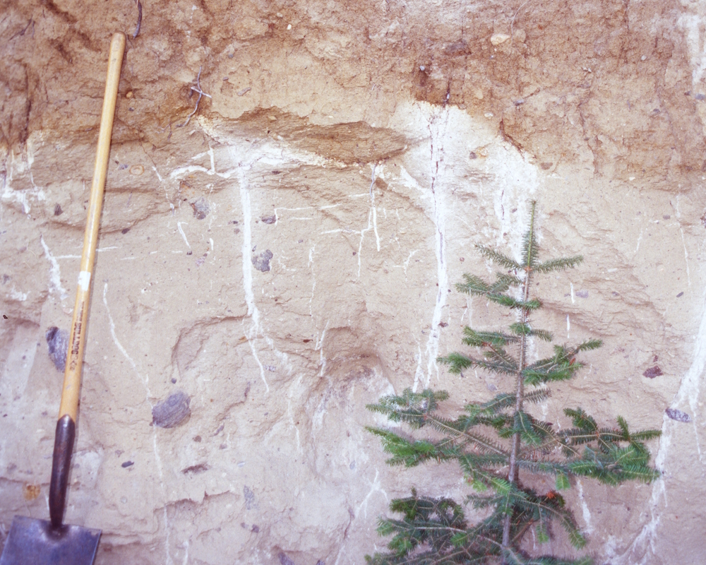
A final distinctive soil-formation pathway is associated with deposits of ash from volcanic activity. These soils are most common in the islands of the “Ring of Fire” such as Japan and parts of Indonesia. In Canada, there are thin volcanic ash additions to many soils in the Western Cordillera and in some soils in the Yukon a distinct, thin volcanic ash can be found (Figure 2.31). Weathering of these volcanic minerals is often very rapid and distinct and highly reactive minerals result from the weathering of the volcanic minerals. The new minerals readily bind with organic matter and phosphorus, and often thick organically enriched horizons occur. These properties are generally called andic properties and give these soils a very high natural fertility compared to other soils of surrounding regions.
SUMMARY
- Canadian soils are young by global standards – almost all Canadian soils are post-glacial (i.e., less than 17,000 to 6,000 years old).
- Because of their youth, many properties (for example, their mineralogy and texture) of Canadian soils are inherited from the parent material in which they form.
- At the national level there are two general classes of parent materials: (i) acidic, coarse-textured glacial drift derived from igneous rocks and (ii) neutral to alkaline, loamy glacial drift derived from pulverization of sedimentary rocks. Parent materials derived from sedimentary rocks have varying contents of carbonates and more soluble salts; parent materials derived from igneous rocks do not.
- Most Canadian soils have formed under a stable assemblage of climate, vegetation, and animals since deglaciation, which results in a characteristic zonation of soils.
- The two main genetic pathways for forest soils in Canada are determined by the two broad classes of parent materials. Soils forming in acidic parent materials experience higher rates of chemical weathering and transfers of iron, aluminum and OM within the profile. Soil forming in weakly acidic to alkaline parent materials initially experience chemical weathering of carbonates and salts followed (in some cases) by transport of fine clay particles within the profile.
- In wetlands, prolonged water saturation limits decomposition of OM and causes a distinctive set of soil-forming processes – the gley processes – to occur. In forested and northern environments, OM builds up to form thick layers of peat. In drier areas of Canada, mineral soils with characteristic dull colours and reddish iron mottling occur in wetlands.
- In the Arctic and tundra regions of Canada, layers of permanently frozen soil (or permafrost) occur. Mixing of soil material caused by frost action often disrupts the formation of distinct soil layers in these soils.
- Grassland soils in Canada, are overwhelmingly associated with alkaline parent materials. High OM inputs from the roots of grasses and mixing by soil organisms creates an organically enriched surface soil layer.
- Two distinct genetic pathways occur in clay-rich parent materials in the grasslands. One pathway involves mixing of soil by shrinking and swelling of clays. The second occurs in parent materials high in sodium and involves the development of a clay-rich middle layer.
- The dominant pathway of soil formation in older, non-glaciated regions involves significant transformations of minerals into secondary clay minerals and iron and aluminum oxides.
STUDY QUESTIONS
- Soils are not rocks, yet the underlying rock has a major influence on soil properties. Why is this?
- The parent material for most Canadian soils has a glacial origin. What are the four main classes of glacial sediments? How would you rank them in terms of suitability for crop growth? Briefly explain your ranking.
- Where would we find the oldest soils in Canada?
- What are the four soil-forming processes? For figures 2.12, 2.14B, 2.16, 2.18, 2.19, 2.20, 2.22, 2.24, and 2.29 identify (in your opinion) what the most important of the four processes is and briefly explain your answer.
- Why does podzolization occur in some forest soils and clay translocation (or lessivage) in others? Based on your understanding of the two processes, which type of soil would be better for tree growth?
- Wetland soils are a major reservoir for carbon. What process is responsible for this?
- How do soil mammals contribute to topsoil development in grassland soils?
- What are the three causes of soil erosion? Which one is most likely to be affected by climate change in your region?
- Why are soils in Canada generally more fertile than soils in non-glaciated region?
REFERENCES
Bedard-Haughn, A. 2011. Gleysolic soils of Canada: Genesis, distribution and classification. Can. J. Soil Sci. 91: 763-779.
Brierly, J.A., Stonehouse, H.B., and Mermut, A.R., 2011. Vertisolic soils of Canada: Genesis, distribution and classification. Can. J. Soil Sci. 91: 903-916.
Dampier, L., Sanborn, P., Smith S., Bond J., and Clague, J. 2011. Genesis of upland soils, Lewes Plateau, central Yukon. Part1: Soils formed on Pleistocene glacial deposits. Can. J. Soil Sci. 91: 563-578.
Dyke, A.S. 2004. An outline of North American deglaciation with emphasis on central and northern Canada. Developments in Quaternary Science 2 Part B: 373-424.
Ellis, J.H. 1938. The Soils of Manitoba. Soils Department, University of Manitoba. Project No.14, Manitoba Economic Survey Board. Published by The Department of Agriculture and Immigration, Province of Manitoba, 112 pp.
Environment and Climate Change Canada. 2016. Canadian Environmental Sustainability Indicators: Extent of Canada’s Wetlands. Available at: www.ec.gc.ca/indicateurs-indicators/default.asp?lang=en&n=69E2D25B-1.
FAO. 2019. Soil erosion: the greatest challenge to sustainable soil management. Food and Agriculture Organization of the United Nations. Rome. 100 pp. Available at: http://www.fao.org/3/ca4395en/ca4395en.pdf
Fenton, M.M., Schreiner, B.T., Nielsen, E., and Pawlowicz, J.G. 1994. Chapter 26 – Quaternary Geology of the Western Plains; Pages 413-421 in G.D. Mossop and I. Shetsen (comp.) Geological Atlas of the Western Canada Sedimentary Basin, Canadian Society of Petroleum Geologists and Alberta Research Council, URL: https://ags.aer.ca/publications/chapter-26-quaternary-geology-of-the-western-plains (Accessed August 22, 2019).
Fox, C.A. and Tarnocai, C. 2011. Organic soils of Canada: Part 2. Upland Organic soils. Can. J. Soil Sci. 91: 823-842.
Fuller, L. 2010. Chernozemic soils of the prairie region of western Canada. Prairie Soils and Crops 3: 37−45. http://www.prairiesoilsandcrops.ca
Jenny, H. 1941. Factors of soil formation: A system of quantitative pedology. McGraw–Hill Inc. New York. (Note: A pdf copy of this book is in the public domain at the Soil & Health Library.
Jenny, H. 1980. The soil resource. Origin and behavior, Springer-Verlag, New York. Pp. 377.
Kodama, H. 1979. Clay minerals in Canadian soils: Their origin, distribution, and alteration. Can. J. Soil Sci. 59: 37-58.
Kroetsch, D.J., Geng, X., Chang, S.X., and Saurette, D.D. 2011. Organic soils of Canada: Part 1. Wetland Organic soils. Can. J. Soil Sci. 91: 807-822.
Krzic M., Sanborn, P. Watson, K., Bomke, A.A., Crowley, C., Doree, A., and Dyanatkar, S. 2008. Soil formation and soil processes. The University of British Columbia, Vancouver, University of Northern British Columbia, and Thompson Rivers University, Kamloops. https://processes.soilweb.ca/
Lavkulich, L.M. and Arocena, J.M. 2011. Luvisolic soils of Canada: Genesis, distribution and classification. Can. J. Soil Sci. 91: 781-806.
Montanarella, L., Pennock, D.J., McKenzie, N., and 26 others. 2016. World’s soils are under threat. Soil 2: 79-82.
Miller, J.J. and Brierly, J.A. 2011. Solonetzic soils of Canada: Genesis, distribution and classification. Can. J. Soil Sci. 91: 889-902.
Paton, T.R., Humphreys, G.S. and Mitchell, P.B. 1996. Soils A New Global View. Yale University press, New Haven and London. Pp. 234.
Pennock, D.J., Bedard-Haughn, A., and Viaud, V. 2011. Chernozemic soils of Canada: Genesis, distribution and classification. Can. J. Soil Sci. 91: 719-747.
Sanborn, P. 2016. The imprint of time on Canadian soil landscapes. Quaternary International 418: 165-179.
Sanborn, P., Lamontagne, L., and Hendershot, P. 2011. Podzolic soils of Canada: Genesis, distribution and classification. Can. J. Soil Sci. 91: 843-880.
Sims R.A. and Baldwin. K.A. 1991. Landform features in northwestern Ontario. For. Can., Ontario Region. Sault Ste. Marie, Ont. C0FRDA Rep. 3312. Ont. Min. Nat. Resour., Thunder Bay. On. NWOFTDU. Rep. 60. 63 p. Available at: http://cfs.nrcan.gc.ca/pubwarehouse/pdfs/9148.pdf
Smith, C.A.S., Webb, K.T., Kenney, E., Anderson, A., and Kroetsch, D. 2011. Brunisolic soils of Canada: Genesis, distribution and classification. Can. J. Soil Sci. 91: 695-717.
Tarnocai, C. and Bockheim, J.G. 2011. Cryosolic soils of Canada: Genesis, distribution and classification. Can. J. Soil Sci. 91: 749-762.
University of Idaho. College of Agricultural and Life Sciences. The Twelve Soil Orders. https://www.uidaho.edu/cals/soil-orders
VandenBygaart, A.J. 2011. Regosolic soils of Canada: Genesis, distribution and classification. Can. J. Soil Sci. 91: 881-887.
Watson, K. and Pennock, D. 2016. Section 3. Soil Profile Description. From: D. Pennock, K. Watson, and P. Sanborn. 2016. Field Handbook for the Soils of Western Canada. Pedology Subcommittee, Canadian Society of Soil Science. Available at https://soilsofcanada.ca/documents/S...escription.pdf
Zaitlin, B. and Hayashi, M. 2012. Interactions between soil biota and the effects on geomorphological features. Geomorphology 157-158:142-152.
About the Author
Dan Pennock, Professor Emeritus, Department of Soil Science, University of Saskatchewan, Saskatoon, Saskatchewan, Canada
Dan Pennock is a Professor Emeritus (or, more simply, a retired professor) of the Department of Soil Science at the University of Saskatchewan. His research career focused on how soils are shaped by their place in the landscape and by the processes (like erosion or water movement) that occur in landscapes. He taught courses in many areas of soil science and geography, and his love of teaching was recognized by the university with a Master Teacher award in 2006. He was made a Fellow of the Canadian Society of Soil Science in 2010. Since his retirement he has collaborated on a number of projects on sustainable management of soils with the Global Soil Partnership of the Food and Agriculture Organization of the United Nations.