
6.2.6: Tsunami Hazard Maps
- Page ID
- 6048

\( \newcommand{\vecs}[1]{\overset { \scriptstyle \rightharpoonup} {\mathbf{#1}} } \)
\( \newcommand{\vecd}[1]{\overset{-\!-\!\rightharpoonup}{\vphantom{a}\smash {#1}}} \)
\( \newcommand{\dsum}{\displaystyle\sum\limits} \)
\( \newcommand{\dint}{\displaystyle\int\limits} \)
\( \newcommand{\dlim}{\displaystyle\lim\limits} \)
\( \newcommand{\id}{\mathrm{id}}\) \( \newcommand{\Span}{\mathrm{span}}\)
( \newcommand{\kernel}{\mathrm{null}\,}\) \( \newcommand{\range}{\mathrm{range}\,}\)
\( \newcommand{\RealPart}{\mathrm{Re}}\) \( \newcommand{\ImaginaryPart}{\mathrm{Im}}\)
\( \newcommand{\Argument}{\mathrm{Arg}}\) \( \newcommand{\norm}[1]{\| #1 \|}\)
\( \newcommand{\inner}[2]{\langle #1, #2 \rangle}\)
\( \newcommand{\Span}{\mathrm{span}}\)
\( \newcommand{\id}{\mathrm{id}}\)
\( \newcommand{\Span}{\mathrm{span}}\)
\( \newcommand{\kernel}{\mathrm{null}\,}\)
\( \newcommand{\range}{\mathrm{range}\,}\)
\( \newcommand{\RealPart}{\mathrm{Re}}\)
\( \newcommand{\ImaginaryPart}{\mathrm{Im}}\)
\( \newcommand{\Argument}{\mathrm{Arg}}\)
\( \newcommand{\norm}[1]{\| #1 \|}\)
\( \newcommand{\inner}[2]{\langle #1, #2 \rangle}\)
\( \newcommand{\Span}{\mathrm{span}}\) \( \newcommand{\AA}{\unicode[.8,0]{x212B}}\)
\( \newcommand{\vectorA}[1]{\vec{#1}} % arrow\)
\( \newcommand{\vectorAt}[1]{\vec{\text{#1}}} % arrow\)
\( \newcommand{\vectorB}[1]{\overset { \scriptstyle \rightharpoonup} {\mathbf{#1}} } \)
\( \newcommand{\vectorC}[1]{\textbf{#1}} \)
\( \newcommand{\vectorD}[1]{\overrightarrow{#1}} \)
\( \newcommand{\vectorDt}[1]{\overrightarrow{\text{#1}}} \)
\( \newcommand{\vectE}[1]{\overset{-\!-\!\rightharpoonup}{\vphantom{a}\smash{\mathbf {#1}}}} \)
\( \newcommand{\vecs}[1]{\overset { \scriptstyle \rightharpoonup} {\mathbf{#1}} } \)
\(\newcommand{\longvect}{\overrightarrow}\)
\( \newcommand{\vecd}[1]{\overset{-\!-\!\rightharpoonup}{\vphantom{a}\smash {#1}}} \)
\(\newcommand{\avec}{\mathbf a}\) \(\newcommand{\bvec}{\mathbf b}\) \(\newcommand{\cvec}{\mathbf c}\) \(\newcommand{\dvec}{\mathbf d}\) \(\newcommand{\dtil}{\widetilde{\mathbf d}}\) \(\newcommand{\evec}{\mathbf e}\) \(\newcommand{\fvec}{\mathbf f}\) \(\newcommand{\nvec}{\mathbf n}\) \(\newcommand{\pvec}{\mathbf p}\) \(\newcommand{\qvec}{\mathbf q}\) \(\newcommand{\svec}{\mathbf s}\) \(\newcommand{\tvec}{\mathbf t}\) \(\newcommand{\uvec}{\mathbf u}\) \(\newcommand{\vvec}{\mathbf v}\) \(\newcommand{\wvec}{\mathbf w}\) \(\newcommand{\xvec}{\mathbf x}\) \(\newcommand{\yvec}{\mathbf y}\) \(\newcommand{\zvec}{\mathbf z}\) \(\newcommand{\rvec}{\mathbf r}\) \(\newcommand{\mvec}{\mathbf m}\) \(\newcommand{\zerovec}{\mathbf 0}\) \(\newcommand{\onevec}{\mathbf 1}\) \(\newcommand{\real}{\mathbb R}\) \(\newcommand{\twovec}[2]{\left[\begin{array}{r}#1 \\ #2 \end{array}\right]}\) \(\newcommand{\ctwovec}[2]{\left[\begin{array}{c}#1 \\ #2 \end{array}\right]}\) \(\newcommand{\threevec}[3]{\left[\begin{array}{r}#1 \\ #2 \\ #3 \end{array}\right]}\) \(\newcommand{\cthreevec}[3]{\left[\begin{array}{c}#1 \\ #2 \\ #3 \end{array}\right]}\) \(\newcommand{\fourvec}[4]{\left[\begin{array}{r}#1 \\ #2 \\ #3 \\ #4 \end{array}\right]}\) \(\newcommand{\cfourvec}[4]{\left[\begin{array}{c}#1 \\ #2 \\ #3 \\ #4 \end{array}\right]}\) \(\newcommand{\fivevec}[5]{\left[\begin{array}{r}#1 \\ #2 \\ #3 \\ #4 \\ #5 \\ \end{array}\right]}\) \(\newcommand{\cfivevec}[5]{\left[\begin{array}{c}#1 \\ #2 \\ #3 \\ #4 \\ #5 \\ \end{array}\right]}\) \(\newcommand{\mattwo}[4]{\left[\begin{array}{rr}#1 \amp #2 \\ #3 \amp #4 \\ \end{array}\right]}\) \(\newcommand{\laspan}[1]{\text{Span}\{#1\}}\) \(\newcommand{\bcal}{\cal B}\) \(\newcommand{\ccal}{\cal C}\) \(\newcommand{\scal}{\cal S}\) \(\newcommand{\wcal}{\cal W}\) \(\newcommand{\ecal}{\cal E}\) \(\newcommand{\coords}[2]{\left\{#1\right\}_{#2}}\) \(\newcommand{\gray}[1]{\color{gray}{#1}}\) \(\newcommand{\lgray}[1]{\color{lightgray}{#1}}\) \(\newcommand{\rank}{\operatorname{rank}}\) \(\newcommand{\row}{\text{Row}}\) \(\newcommand{\col}{\text{Col}}\) \(\renewcommand{\row}{\text{Row}}\) \(\newcommand{\nul}{\text{Nul}}\) \(\newcommand{\var}{\text{Var}}\) \(\newcommand{\corr}{\text{corr}}\) \(\newcommand{\len}[1]{\left|#1\right|}\) \(\newcommand{\bbar}{\overline{\bvec}}\) \(\newcommand{\bhat}{\widehat{\bvec}}\) \(\newcommand{\bperp}{\bvec^\perp}\) \(\newcommand{\xhat}{\widehat{\xvec}}\) \(\newcommand{\vhat}{\widehat{\vvec}}\) \(\newcommand{\uhat}{\widehat{\uvec}}\) \(\newcommand{\what}{\widehat{\wvec}}\) \(\newcommand{\Sighat}{\widehat{\Sigma}}\) \(\newcommand{\lt}{<}\) \(\newcommand{\gt}{>}\) \(\newcommand{\amp}{&}\) \(\definecolor{fillinmathshade}{gray}{0.9}\)Overview
Following the 1992 Cape Mendocino Earthquake, the California Governor’s Office of Emergency Services and the Federal Emergency Management Agency (FEMA) funded a study of the effects of an earthquake of M 8.4 on the Cascadia Subduction Zone for the 150-mile distance across Humboldt and Del Norte counties between Cape Mendocino and Cape Blanco, Oregon. This was published by the California Division of Mines and Geology as Toppozada et al. (1995). As part of this scenario, NOAA produced tsunami inundation studies of the Crescent City and Humboldt Bay areas. In the scenario, the tsunami arrived just minutes after the earthquake, which meant that there was not enough time to order an evacuation. Waves were higher than thirty feet. The Samoa Peninsula was inundated, as was the village of King Salmon, which faces the opening of Humboldt Bay. Earthquake damage to road approaches would prevent immediate aid from reaching the Samoa Peninsula. A possible refuge for residents would be a ridge of wooded dunes just west of Manila, two miles north of Samoa and four miles north of Fairhaven. At Crescent City, the scenario tsunami runup was higher than the 1964 tsunami, with severe damage expected in the developed area along the shoreline south of Front and M Streets.
In October 1994, Senator Mark Hatfield of Oregon asked for a report on preparedness against tsunamis, especially a tsunami generated on the Cascadia Subduction Zone. A year later, the Senate requested a plan for implementation with a budget. This led to the establishment in December 1996 of the National Tsunami Hazard Mitigation Program for the five Pacific Coast states, under the direction of NOAA and in collaboration with FEMA and the USGS. This program, with a budget of about $2 million per year, supports tsunami inundation modeling in states bordering the Pacific Ocean, tsunami mitigation activities, upgrading seismic networks, and deep-ocean pressure gauges. As part of this program, the Center for Tsunami Inundation Mapping Efforts (TIME) was established at NOAA’s laboratory at the Hatfield Marine Science in Newport, Oregon. Research is underway to improve and integrate tsunami modeling with real-time observations. Tsunami inundation maps are constructed using computer models of the earthquake source as well as the configuration of the continental slope and shelf and coastal bays, harbors, and estuaries. The tsunami maps show where tsunamis are likely to be focused, such as they were at Hilo, Hawaii and Crescent City, California.
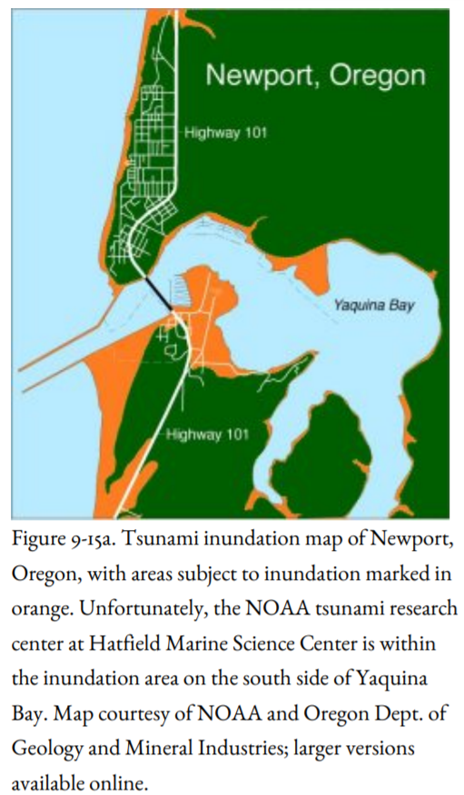
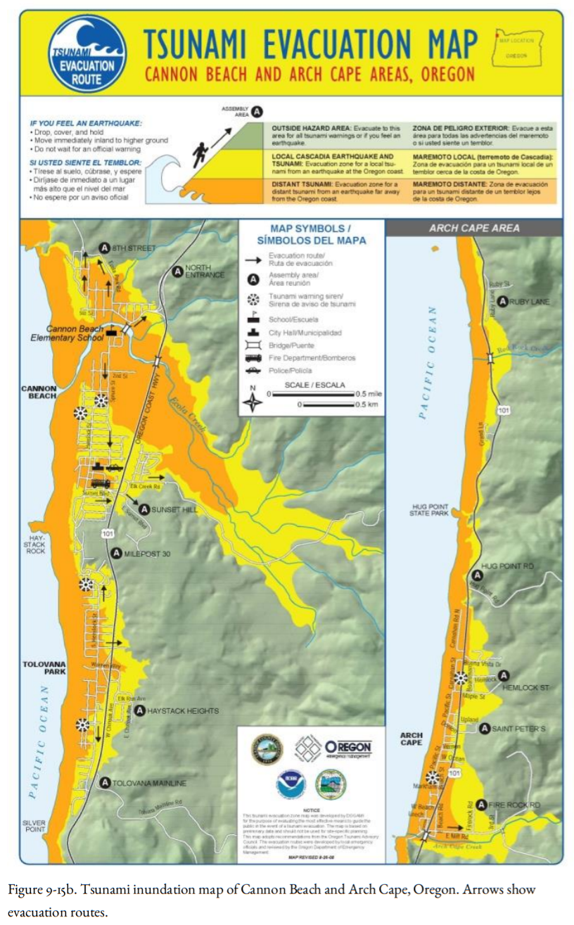
During the first year of the program, all of the mapping funds went to Oregon and Washington, with tsunami maps at Newport, Cannon Beach, and Arch Cape, Oregon (Figure 9-15a, b). In 1995, Oregon enacted legislation that limits the construction of new essential facilities and special-occupancy structures in tsunami flooding zones, although the NOAA research lab investigating tsunamis at the Hatfield Marine Science Center is, unfortunately, within the tsunami inundation zone. Directed by this new law, the Department of Geology and Mineral Industries (DOGAMI) prepared a series of tsunami hazard maps at a scale of one inch to 2,000 feet of the entire Oregon coast (available as Open-File Reports O-95-09 through O-95-66 and explained in O-95-67, which also contains an index map of the individual tsunami warning maps). If you live at the coast, you can obtain a map of your area from DOGAMI.
In the 1990s, DOGAMI designed a tsunami warning logo to be posted on Oregon beaches. This logo (Figure 9-16) now has been adopted around the world. The tsunami logo is seen along Highway 101 where the road drops in elevation to within the tsunami runup zone. Evacuation routes are identified by the logo and an arrow showing which direction to evacuate. At my condo at Nye Beach in Newport, we designed an evacuation map that is posted in all condo units, including the instructions to not depend on elevators or your car to get you away from the inundation zone. OSU has an extension agent, Pat Corcoran, who lives at the coast and has the responsibility of informing the public about tsunami hazards.
The National Tsunami Hazards Mitigation Program supported the preparation of a tsunami hazard map of the southern Washington coast from Taholah, north of Pt. Grenville, to the Columbia River. As in Oregon, the location of maximum tsunami runup is based on computer models including the topography of the seafloor. This study also estimated the time of arrival of the first large tsunami: thirty minutes or less for communities directly facing the Pacific Ocean like Taholah, Long Beach, and Westport, but at least an hour for communities within Grays Harbor or Willapa Bay, including Aberdeen, Hoquiam, and Bay Center. NOAA is also preparing scenarios for a tsunami following an earthquake on the Seattle Fault, which would produce large waves in Elliott Bay in downtown Seattle.
What warning should be given to coastal residents in case of an earthquake? On the Oregon and Washington coast, strong shaking is likely to mean an earthquake on the subduction zone, and residents are advised to evacuate to higher ground without waiting for a tsunami warning. But what about crustal earthquakes that do not generate tsunamis? The city of Santa Cruz, California, underwent strong shaking during the 1989 Loma Prieta Earthquake, and Santa Monica was damaged by the 1994 Northridge Earthquake; neither earthquake generated a tsunami. Should the residents evacuate without official notice in earthquakes like those? Probably not. Even the 1906 San Francisco Earthquake, which had its epicenter offshore west of the Golden Gate, did not generate a tsunami large enough to warrant evacuation.
Attention has also been given to locations where residents would not have time to evacuate to high ground. At Cannon Beach, for example, a stream lies between the beach and high ground (Figure 9-15b). Evacuation drills have suggested that fifteen or twenty minutes would not be enough time to get everyone to high ground, particularly people with disabilities. The bridges would be jammed with cars. In this case, an alternate option is vertical evacuation: to the upper floors of beachfront hotels. Figure 9-17 shows an alternative: put your beachfront home on stilts! An Oregon coastal town proposed a new city hall using this principle, but the decision makers were unable to follow through with raising the money to do it.