
5.6.9: The Pasco Basin- Nuclear Wastes and Earthquakes
- Page ID
- 5991

\( \newcommand{\vecs}[1]{\overset { \scriptstyle \rightharpoonup} {\mathbf{#1}} } \)
\( \newcommand{\vecd}[1]{\overset{-\!-\!\rightharpoonup}{\vphantom{a}\smash {#1}}} \)
\( \newcommand{\id}{\mathrm{id}}\) \( \newcommand{\Span}{\mathrm{span}}\)
( \newcommand{\kernel}{\mathrm{null}\,}\) \( \newcommand{\range}{\mathrm{range}\,}\)
\( \newcommand{\RealPart}{\mathrm{Re}}\) \( \newcommand{\ImaginaryPart}{\mathrm{Im}}\)
\( \newcommand{\Argument}{\mathrm{Arg}}\) \( \newcommand{\norm}[1]{\| #1 \|}\)
\( \newcommand{\inner}[2]{\langle #1, #2 \rangle}\)
\( \newcommand{\Span}{\mathrm{span}}\)
\( \newcommand{\id}{\mathrm{id}}\)
\( \newcommand{\Span}{\mathrm{span}}\)
\( \newcommand{\kernel}{\mathrm{null}\,}\)
\( \newcommand{\range}{\mathrm{range}\,}\)
\( \newcommand{\RealPart}{\mathrm{Re}}\)
\( \newcommand{\ImaginaryPart}{\mathrm{Im}}\)
\( \newcommand{\Argument}{\mathrm{Arg}}\)
\( \newcommand{\norm}[1]{\| #1 \|}\)
\( \newcommand{\inner}[2]{\langle #1, #2 \rangle}\)
\( \newcommand{\Span}{\mathrm{span}}\) \( \newcommand{\AA}{\unicode[.8,0]{x212B}}\)
\( \newcommand{\vectorA}[1]{\vec{#1}} % arrow\)
\( \newcommand{\vectorAt}[1]{\vec{\text{#1}}} % arrow\)
\( \newcommand{\vectorB}[1]{\overset { \scriptstyle \rightharpoonup} {\mathbf{#1}} } \)
\( \newcommand{\vectorC}[1]{\textbf{#1}} \)
\( \newcommand{\vectorD}[1]{\overrightarrow{#1}} \)
\( \newcommand{\vectorDt}[1]{\overrightarrow{\text{#1}}} \)
\( \newcommand{\vectE}[1]{\overset{-\!-\!\rightharpoonup}{\vphantom{a}\smash{\mathbf {#1}}}} \)
\( \newcommand{\vecs}[1]{\overset { \scriptstyle \rightharpoonup} {\mathbf{#1}} } \)
\( \newcommand{\vecd}[1]{\overset{-\!-\!\rightharpoonup}{\vphantom{a}\smash {#1}}} \)
\(\newcommand{\avec}{\mathbf a}\) \(\newcommand{\bvec}{\mathbf b}\) \(\newcommand{\cvec}{\mathbf c}\) \(\newcommand{\dvec}{\mathbf d}\) \(\newcommand{\dtil}{\widetilde{\mathbf d}}\) \(\newcommand{\evec}{\mathbf e}\) \(\newcommand{\fvec}{\mathbf f}\) \(\newcommand{\nvec}{\mathbf n}\) \(\newcommand{\pvec}{\mathbf p}\) \(\newcommand{\qvec}{\mathbf q}\) \(\newcommand{\svec}{\mathbf s}\) \(\newcommand{\tvec}{\mathbf t}\) \(\newcommand{\uvec}{\mathbf u}\) \(\newcommand{\vvec}{\mathbf v}\) \(\newcommand{\wvec}{\mathbf w}\) \(\newcommand{\xvec}{\mathbf x}\) \(\newcommand{\yvec}{\mathbf y}\) \(\newcommand{\zvec}{\mathbf z}\) \(\newcommand{\rvec}{\mathbf r}\) \(\newcommand{\mvec}{\mathbf m}\) \(\newcommand{\zerovec}{\mathbf 0}\) \(\newcommand{\onevec}{\mathbf 1}\) \(\newcommand{\real}{\mathbb R}\) \(\newcommand{\twovec}[2]{\left[\begin{array}{r}#1 \\ #2 \end{array}\right]}\) \(\newcommand{\ctwovec}[2]{\left[\begin{array}{c}#1 \\ #2 \end{array}\right]}\) \(\newcommand{\threevec}[3]{\left[\begin{array}{r}#1 \\ #2 \\ #3 \end{array}\right]}\) \(\newcommand{\cthreevec}[3]{\left[\begin{array}{c}#1 \\ #2 \\ #3 \end{array}\right]}\) \(\newcommand{\fourvec}[4]{\left[\begin{array}{r}#1 \\ #2 \\ #3 \\ #4 \end{array}\right]}\) \(\newcommand{\cfourvec}[4]{\left[\begin{array}{c}#1 \\ #2 \\ #3 \\ #4 \end{array}\right]}\) \(\newcommand{\fivevec}[5]{\left[\begin{array}{r}#1 \\ #2 \\ #3 \\ #4 \\ #5 \\ \end{array}\right]}\) \(\newcommand{\cfivevec}[5]{\left[\begin{array}{c}#1 \\ #2 \\ #3 \\ #4 \\ #5 \\ \end{array}\right]}\) \(\newcommand{\mattwo}[4]{\left[\begin{array}{rr}#1 \amp #2 \\ #3 \amp #4 \\ \end{array}\right]}\) \(\newcommand{\laspan}[1]{\text{Span}\{#1\}}\) \(\newcommand{\bcal}{\cal B}\) \(\newcommand{\ccal}{\cal C}\) \(\newcommand{\scal}{\cal S}\) \(\newcommand{\wcal}{\cal W}\) \(\newcommand{\ecal}{\cal E}\) \(\newcommand{\coords}[2]{\left\{#1\right\}_{#2}}\) \(\newcommand{\gray}[1]{\color{gray}{#1}}\) \(\newcommand{\lgray}[1]{\color{lightgray}{#1}}\) \(\newcommand{\rank}{\operatorname{rank}}\) \(\newcommand{\row}{\text{Row}}\) \(\newcommand{\col}{\text{Col}}\) \(\renewcommand{\row}{\text{Row}}\) \(\newcommand{\nul}{\text{Nul}}\) \(\newcommand{\var}{\text{Var}}\) \(\newcommand{\corr}{\text{corr}}\) \(\newcommand{\len}[1]{\left|#1\right|}\) \(\newcommand{\bbar}{\overline{\bvec}}\) \(\newcommand{\bhat}{\widehat{\bvec}}\) \(\newcommand{\bperp}{\bvec^\perp}\) \(\newcommand{\xhat}{\widehat{\xvec}}\) \(\newcommand{\vhat}{\widehat{\vvec}}\) \(\newcommand{\uhat}{\widehat{\uvec}}\) \(\newcommand{\what}{\widehat{\wvec}}\) \(\newcommand{\Sighat}{\widehat{\Sigma}}\) \(\newcommand{\lt}{<}\) \(\newcommand{\gt}{>}\) \(\newcommand{\amp}{&}\) \(\definecolor{fillinmathshade}{gray}{0.9}\)Overview
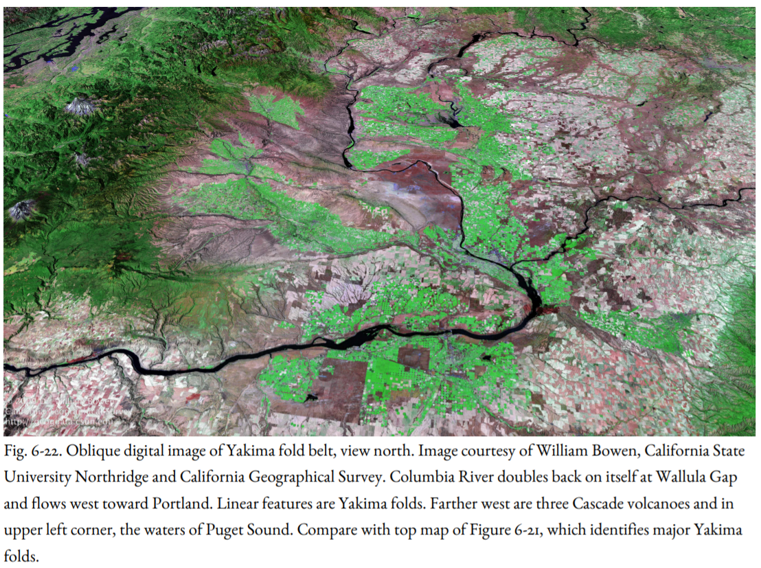
The military aircraft droned over the bleak December landscape of eastern Washington, and its lone passenger took note of what he saw through the window. As he gazed down at the sagebrush-covered Hanford Reach, with the broad ribbon of the Columbia River curving away in the distance, Lt. Col. Franklin Matthias knew that he had the site he wanted: raw desert, virtually unpopulated, but with a dependable water source, the Columbia River, close at hand (Figure 6-22). The nearest large city, Spokane, was nearly one hundred and twenty miles away. Matthias would report back to his superior, General Leslie Groves, the military overseer for the top-secret Manhattan Project, that Hanford was suitable for a large supersecret government operation related to the war effort. The year was 1942.
Soon after, in 1943, the few Indians and farmers who had been scratching out a living in the Hanford Reach were hustled out, and the government took over for a crash project to manufacture plutonium for an atomic bomb, the first of which would be dropped two years later on Nagasaki, Japan, bringing an end to World War II. Then came the Cold War, and Hanford continued to expand, still in secrecy, bringing jobs and prosperity to the Pasco Basin and the Tri-Cities of Richland, Pasco, and Kennewick. In addition to manufacturing plutonium, atomic reactors produced energy for the Bonneville power grid, and nuclear wastes began to be stored on the Hanford Reach.
In the 1980s, the site was proposed as a national nuclear waste dump, the Basalt Waste Isolation Project. By this time, though, serious reservations had been expressed about nuclear waste disposal in general and the Hanford site in particular. The Hanford N Reactor and the plutonium manufacturing facilities were shut down, and later, the proposed waste disposal site was shifted to Yucca Mountain in Nevada.
But still the legacy of nuclear wastes already stored at Hanford hangs over the Tri-Cities, and so it is useful now to look at the geologic setting and consider Hanford’s hazard from earthquakes. Clearly, geology and earthquakes were not considered at all in Col. Matthias’s report to General Groves. Now, however, a nuclear reactor is considered to be a critical facility, meaning that it is necessary to conduct exhaustive site studies to determine its long-term stability to hazards, even those that might be very unlikely, including earthquakes. Are the reactors and the plutonium manufacturing plants able to withstand earthquake shaking? Would highly toxic radioactive waste stored in subterranean tunnels leak out following a major earthquake? To answer these questions, we look for evidence for past earthquakes in the geology around the site, especially in the long ridges of basalt known as the Yakima Folds (Figure 6-23).
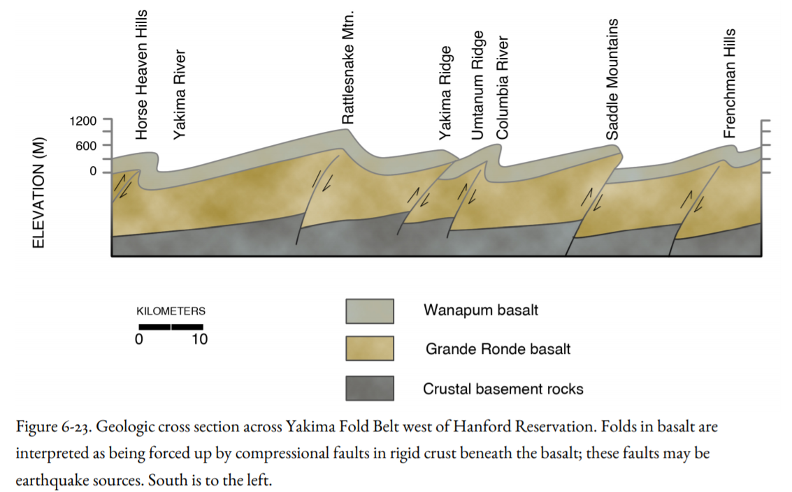
Between Wenatchee and Hanford, the Columbia River turns southeast through a sagebrush-covered black-rock wasteland, away from the ocean, to cut a succession of gorges through basalt ridges on its way to the last canyon, Wallula Gap, where it turns sharply back on itself and heads west to Portland (Figures 6-21, 6-22). These basalt ridges, Frenchman Hills, Saddle Mountain, and Rattlesnake Mountain, are anticlinal folds in the Columbia River Basalt, crumpled like a heavy carpet after a sofa has been pushed over it (Figure 6-23). The Columbia has eroded through these anticlines as they formed. The anticlines are best seen in the canyon of the Yakima River between the towns of Ellensburg and Yakima—not from Interstate 82, which soars high over the gorge, but on the lonely State Highway 821, which twists along the banks of the Yakima as the river lazes across broad synclines and churns through anticlinal cliffs of basalt.
Project managers working at the Hanford Nuclear Reservation tended to downplay the role earthquakes may have had in forming these anticlinal ridges, perhaps from wishful thinking, perhaps because they did not want to answer questions they had not been asked. One theory was that the anticlines formed millions of years ago, during or soon after the eruption of basalt, and were no longer active or an earthquake risk.
In fairness to the geologists and managers at Hanford, anticlines were not considered as harbingers of earthquakes until 1983, when an earthquake of M 6.7 trashed the downtown section of Coalinga, California, a small town on the west side of the San Joaquin Valley. There was no active fault at the surface at Coalinga, but the forces accompanying the earthquake were shown to add to the folding of an anticline at the surface. The implication of active folding is that the fold is underlain by a blind reverse fault or blind thrust, one that does not reach the surface, but tends to force one block over another: faulting at depth, but only bending at the surface (Figure 3-10b). The 1994 Northridge California, Earthquake was caused by rupture on a blind thrust.
I once saw a Volkswagen bus that had been in a highway accident. There had been a carpet on the floor, as if its owner had been camping inside the bus. During the wreck, the flooring was buckled and broken, but the carpet was still continuous over the flooring, although it had a large hump in it over the break in the flooring. I thought about that VW bus as I studied the Northridge Earthquake—the bump in the carpet was the anticline, giving a silent clue to the unseen fault beneath. The same analogy could be made for the basalt ridges in the Pasco Basin.
Two college teachers, Bob Bentley of Central Washington University in Ellensburg and Newell Campbell of Yakima Valley College, trudged into Yakama Indian territory to examine Toppenish Ridge, a narrow anticline south of the city of Yakima (left center, Figure 6-21, top). They found normal faults on the crest of the anticline and reverse faults on its north flank where the anticline had been thrust northward toward the plowed fields of the Yakima Valley. These structures are not the same age as the Columbia River Basalt; they are much younger, possibly still active. Similar evidence later showed that the east end of the Saddle Mountain Anticline, east of the Columbia and north of Hanford, is also active. As shown in Figure 6-23, the prominent anticlines overlie and provide evidence for blind reverse faults beneath, faults that themselves could produce large earthquakes at the nuclear reservation.
The Olympia-Wallowa Lineament (OWL) traverses southeast across the Hanford Reach and across the Yakima folds. Although it is visible on satellite images and on computer-generated digital topographic maps (Figure 6-22), its earthquake significance is unclear.
In summary, as Hanford’s nuclear operations change into environmental cleanup mode, and the Tri-Cities await their fate, an earthquake assessment seems long overdue. The Hanford installation is not the only critical facility in the Pasco Basin; there are also the Wanapum, Priest Rapids, and McNary dams on the Columbia River. Failure of one of these dams could cause a repeat of the catastrophic floods of the Pleistocene, although on a greatly reduced scale. Critical facilities will be considered in a later chapter.