
5.6.5: The Portland Hills Fault
- Page ID
- 5979

\( \newcommand{\vecs}[1]{\overset { \scriptstyle \rightharpoonup} {\mathbf{#1}} } \)
\( \newcommand{\vecd}[1]{\overset{-\!-\!\rightharpoonup}{\vphantom{a}\smash {#1}}} \)
\( \newcommand{\id}{\mathrm{id}}\) \( \newcommand{\Span}{\mathrm{span}}\)
( \newcommand{\kernel}{\mathrm{null}\,}\) \( \newcommand{\range}{\mathrm{range}\,}\)
\( \newcommand{\RealPart}{\mathrm{Re}}\) \( \newcommand{\ImaginaryPart}{\mathrm{Im}}\)
\( \newcommand{\Argument}{\mathrm{Arg}}\) \( \newcommand{\norm}[1]{\| #1 \|}\)
\( \newcommand{\inner}[2]{\langle #1, #2 \rangle}\)
\( \newcommand{\Span}{\mathrm{span}}\)
\( \newcommand{\id}{\mathrm{id}}\)
\( \newcommand{\Span}{\mathrm{span}}\)
\( \newcommand{\kernel}{\mathrm{null}\,}\)
\( \newcommand{\range}{\mathrm{range}\,}\)
\( \newcommand{\RealPart}{\mathrm{Re}}\)
\( \newcommand{\ImaginaryPart}{\mathrm{Im}}\)
\( \newcommand{\Argument}{\mathrm{Arg}}\)
\( \newcommand{\norm}[1]{\| #1 \|}\)
\( \newcommand{\inner}[2]{\langle #1, #2 \rangle}\)
\( \newcommand{\Span}{\mathrm{span}}\) \( \newcommand{\AA}{\unicode[.8,0]{x212B}}\)
\( \newcommand{\vectorA}[1]{\vec{#1}} % arrow\)
\( \newcommand{\vectorAt}[1]{\vec{\text{#1}}} % arrow\)
\( \newcommand{\vectorB}[1]{\overset { \scriptstyle \rightharpoonup} {\mathbf{#1}} } \)
\( \newcommand{\vectorC}[1]{\textbf{#1}} \)
\( \newcommand{\vectorD}[1]{\overrightarrow{#1}} \)
\( \newcommand{\vectorDt}[1]{\overrightarrow{\text{#1}}} \)
\( \newcommand{\vectE}[1]{\overset{-\!-\!\rightharpoonup}{\vphantom{a}\smash{\mathbf {#1}}}} \)
\( \newcommand{\vecs}[1]{\overset { \scriptstyle \rightharpoonup} {\mathbf{#1}} } \)
\( \newcommand{\vecd}[1]{\overset{-\!-\!\rightharpoonup}{\vphantom{a}\smash {#1}}} \)
\(\newcommand{\avec}{\mathbf a}\) \(\newcommand{\bvec}{\mathbf b}\) \(\newcommand{\cvec}{\mathbf c}\) \(\newcommand{\dvec}{\mathbf d}\) \(\newcommand{\dtil}{\widetilde{\mathbf d}}\) \(\newcommand{\evec}{\mathbf e}\) \(\newcommand{\fvec}{\mathbf f}\) \(\newcommand{\nvec}{\mathbf n}\) \(\newcommand{\pvec}{\mathbf p}\) \(\newcommand{\qvec}{\mathbf q}\) \(\newcommand{\svec}{\mathbf s}\) \(\newcommand{\tvec}{\mathbf t}\) \(\newcommand{\uvec}{\mathbf u}\) \(\newcommand{\vvec}{\mathbf v}\) \(\newcommand{\wvec}{\mathbf w}\) \(\newcommand{\xvec}{\mathbf x}\) \(\newcommand{\yvec}{\mathbf y}\) \(\newcommand{\zvec}{\mathbf z}\) \(\newcommand{\rvec}{\mathbf r}\) \(\newcommand{\mvec}{\mathbf m}\) \(\newcommand{\zerovec}{\mathbf 0}\) \(\newcommand{\onevec}{\mathbf 1}\) \(\newcommand{\real}{\mathbb R}\) \(\newcommand{\twovec}[2]{\left[\begin{array}{r}#1 \\ #2 \end{array}\right]}\) \(\newcommand{\ctwovec}[2]{\left[\begin{array}{c}#1 \\ #2 \end{array}\right]}\) \(\newcommand{\threevec}[3]{\left[\begin{array}{r}#1 \\ #2 \\ #3 \end{array}\right]}\) \(\newcommand{\cthreevec}[3]{\left[\begin{array}{c}#1 \\ #2 \\ #3 \end{array}\right]}\) \(\newcommand{\fourvec}[4]{\left[\begin{array}{r}#1 \\ #2 \\ #3 \\ #4 \end{array}\right]}\) \(\newcommand{\cfourvec}[4]{\left[\begin{array}{c}#1 \\ #2 \\ #3 \\ #4 \end{array}\right]}\) \(\newcommand{\fivevec}[5]{\left[\begin{array}{r}#1 \\ #2 \\ #3 \\ #4 \\ #5 \\ \end{array}\right]}\) \(\newcommand{\cfivevec}[5]{\left[\begin{array}{c}#1 \\ #2 \\ #3 \\ #4 \\ #5 \\ \end{array}\right]}\) \(\newcommand{\mattwo}[4]{\left[\begin{array}{rr}#1 \amp #2 \\ #3 \amp #4 \\ \end{array}\right]}\) \(\newcommand{\laspan}[1]{\text{Span}\{#1\}}\) \(\newcommand{\bcal}{\cal B}\) \(\newcommand{\ccal}{\cal C}\) \(\newcommand{\scal}{\cal S}\) \(\newcommand{\wcal}{\cal W}\) \(\newcommand{\ecal}{\cal E}\) \(\newcommand{\coords}[2]{\left\{#1\right\}_{#2}}\) \(\newcommand{\gray}[1]{\color{gray}{#1}}\) \(\newcommand{\lgray}[1]{\color{lightgray}{#1}}\) \(\newcommand{\rank}{\operatorname{rank}}\) \(\newcommand{\row}{\text{Row}}\) \(\newcommand{\col}{\text{Col}}\) \(\renewcommand{\row}{\text{Row}}\) \(\newcommand{\nul}{\text{Nul}}\) \(\newcommand{\var}{\text{Var}}\) \(\newcommand{\corr}{\text{corr}}\) \(\newcommand{\len}[1]{\left|#1\right|}\) \(\newcommand{\bbar}{\overline{\bvec}}\) \(\newcommand{\bhat}{\widehat{\bvec}}\) \(\newcommand{\bperp}{\bvec^\perp}\) \(\newcommand{\xhat}{\widehat{\xvec}}\) \(\newcommand{\vhat}{\widehat{\vvec}}\) \(\newcommand{\uhat}{\widehat{\uvec}}\) \(\newcommand{\what}{\widehat{\wvec}}\) \(\newcommand{\Sighat}{\widehat{\Sigma}}\) \(\newcommand{\lt}{<}\) \(\newcommand{\gt}{>}\) \(\newcommand{\amp}{&}\) \(\definecolor{fillinmathshade}{gray}{0.9}\)Overview
Sixteen million years ago, great floods of basaltic lava issued from crustal fractures in easternmost Washington and Oregon and western Idaho and poured across the Columbia Plateau in a broad front, hemmed in only by the Cascades, through which the lava burst in a fiery flood more than twenty miles across to enter the northern Willamette Valley and finally to flow into the sea. These lava eruptions have no counterpart in human history. One cannot imagine looking toward an advancing front of molten basalt extending from horizon to horizon, from the Columbia River at Portland south to the Waldo Hills east of Salem, Oregon, flowing faster than one could ride a horse, almost like water. This happened not just once but dozens of times over several million years.
Long after the basalt lava had frozen into stone, less than a hundred thousand years ago, there was a different kind of catastrophe. During the Pleistocene, the interior of British Columbia was covered by a vast ice cap, like Greenland today, and glaciers had advanced southward into northern Washington, damming the Columbia River and its tributaries at Spokane to form a huge body of freshwater, Glacial Lake Missoula, that extended across Idaho into Montana, almost to the Continental Divide. At the end of the Pleistocene, the glaciers began to melt and retreat, and the ice dam at Spokane suddenly ruptured. The lake drained first beneath the ice, then floated the ice roof and caused it to collapse. The resulting iceberg-strewn deluge, lasting at least a week, drained Lake Missoula, briefly carrying more water than all the streams on Earth do today.
Nothing else on Earth matched this apocalyptic Missoula flood. The great volume of water was too much for the valley of the Columbia River, and water rushed across the Columbia Plateau, ripping away the rich Palouse soil and eroding down to the bare basalt, forming a broad wasteland called the Channeled Scablands. The thundering torrents carved out the Grand Coulee and Dry Falls and deposited giant sandbars on the Columbia River below Wenatchee, so large that they can be seen from space. Like its basaltic predecessor millions of years before, the water flowed out across a broad front. The doomsday scenario repeated itself many times as the ice cap retreated, then advanced, then retreated, over and over again. The last time was about twelve thousand years ago.
Satellite images of the Portland metropolitan area show the effects of these giant floods, scouring out the bases of Pleistocene volcanoes and carving canyons through the basalt mountains, one now occupied by Lake Oswego, a Portland suburb (Figure 6-11). For the geologist looking for active faults, the effect is the same as the grinding of glaciers in Puget Sound: the floods erased any evidence of active fault scarps older than twelve thousand years as far south as Eugene.
Yet there is one feature that is hard to miss: the straight-line base of the Portland Hills in downtown Portland (Figure 6-15). The hills are underlain by Columbia River Basalt, arched upward into an anticline, that may be related to the origin of Willamette Falls at Oregon City. The late Marvin Beeson of Portland State University described the Portland Hills structure and fault, which is more or less parallel to the St. Helens Seismic Zone to the north and the Mount Angel Fault to the south, both suspected of being right-lateral strike-slip faults. For a long time, proof of its activity was lacking, although for earthquake hazard planning exercises, it was assumed to be capable of an earthquake of magnitude greater than 7, the most dangerous fault in Oregon aside from the subduction-zone fault.
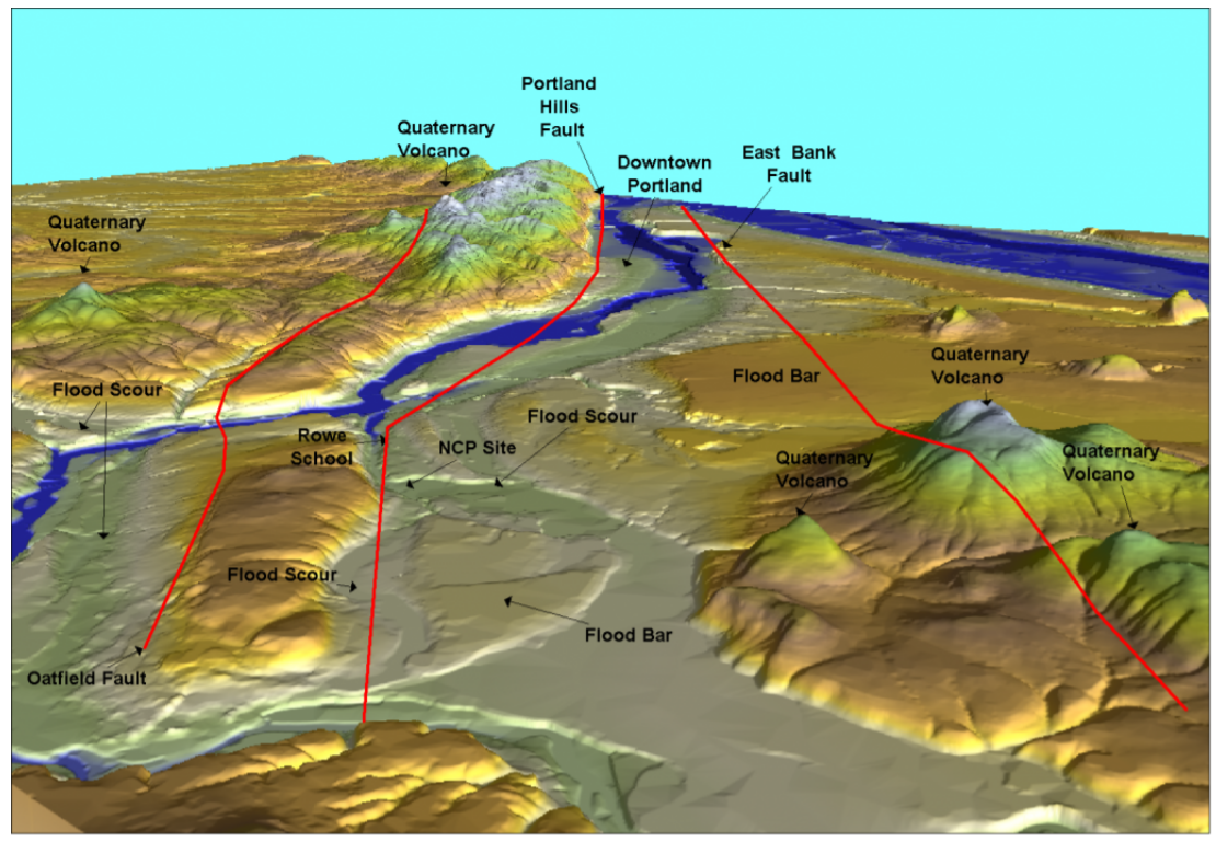
Ivan Wong of URS Greiner and Associates and Ian Madin of the Oregon Department of Geology and Mineral Industries decided to look for the smoking gun that would show if the fault is active or not. Seismic surveys along the Willamette River by Tom Pratt of the USGS and Lee Liberty of Boise State University provided hints that the fault cuts the latest Pleistocene Missoula flood deposits. These distinctive deposits are rhythmically bedded, with each bed deposited by one of the catastrophic Missoula floods in the latest Pleistocene. A detailed seismic survey in North Clackamas Park southeast of Milwaukie (NCP, located on Figure 6-14) provided evidence that the flood deposits may be deformed. Then somebody noticed a retaining-wall excavation at Rowe Middle School, not far from North Clackamas Park. In this excavation, the Missoula flood deposits are clearly folded. The first Oregon fault west of the Cascades could now be classified as possibly active.
In addition, excavations for an expansion of the Oregon Convention Center showed Missoula flood deposits that are cut by sand dikes, generally considered to be formed by liquefaction, diagnostic for an earthquake origin. However, could these dikes have been produced by a subduction-zone earthquake? Could they somehow be related to the massive amount of water that repeatedly covered the area in the latest Pleistocene? Preliminary examination of excavations around Portland suggests only one episode of sand dike formation, suggesting to me that they formed during one high-intensity crustal earthquake rather than repeated subduction-zone earthquakes or repeated flooding episodes. However, this is not a “smoking gun” evidence.
Geophysical studies by Rick Blakely and his colleagues at the USGS revealed two additional faults parallel to the Portland Hills Fault, the East Bank Fault following the east side of the Willamette River to Mt. Scott, an inactive Quaternary volcano, and the Oatfield Fault on the west slope of the Portland Hills extending southeast to Lake Oswego and Gladstone (Figure 6-14). So, like the Seattle Fault, the Portland Hills Fault is a broad zone of faulting rather than a single fault. However, it is poorly located, even in downtown Portland.
Portland has an earthquake history, with the largest number of earthquakes recorded anywhere in Oregon. Partly this is an accident of early settlement of the Portland Basin. An earthquake on October 12, 1877, resulted in intensities as high as VII in Portland. Lower-intensity earthquakes were recorded in Portland on February 3, 1892, December 29, 1941, and December 15, 1953. The best-studied earthquake struck on November 5, 1962, with an epicenter near Vancouver and a magnitude of 5.2 to 5.5. This earthquake caused minor damage, including fallen chimneys and broken windows.