
6.1.4: Landslides Generated by Earthquakes
- Page ID
- 6040

\( \newcommand{\vecs}[1]{\overset { \scriptstyle \rightharpoonup} {\mathbf{#1}} } \)
\( \newcommand{\vecd}[1]{\overset{-\!-\!\rightharpoonup}{\vphantom{a}\smash {#1}}} \)
\( \newcommand{\dsum}{\displaystyle\sum\limits} \)
\( \newcommand{\dint}{\displaystyle\int\limits} \)
\( \newcommand{\dlim}{\displaystyle\lim\limits} \)
\( \newcommand{\id}{\mathrm{id}}\) \( \newcommand{\Span}{\mathrm{span}}\)
( \newcommand{\kernel}{\mathrm{null}\,}\) \( \newcommand{\range}{\mathrm{range}\,}\)
\( \newcommand{\RealPart}{\mathrm{Re}}\) \( \newcommand{\ImaginaryPart}{\mathrm{Im}}\)
\( \newcommand{\Argument}{\mathrm{Arg}}\) \( \newcommand{\norm}[1]{\| #1 \|}\)
\( \newcommand{\inner}[2]{\langle #1, #2 \rangle}\)
\( \newcommand{\Span}{\mathrm{span}}\)
\( \newcommand{\id}{\mathrm{id}}\)
\( \newcommand{\Span}{\mathrm{span}}\)
\( \newcommand{\kernel}{\mathrm{null}\,}\)
\( \newcommand{\range}{\mathrm{range}\,}\)
\( \newcommand{\RealPart}{\mathrm{Re}}\)
\( \newcommand{\ImaginaryPart}{\mathrm{Im}}\)
\( \newcommand{\Argument}{\mathrm{Arg}}\)
\( \newcommand{\norm}[1]{\| #1 \|}\)
\( \newcommand{\inner}[2]{\langle #1, #2 \rangle}\)
\( \newcommand{\Span}{\mathrm{span}}\) \( \newcommand{\AA}{\unicode[.8,0]{x212B}}\)
\( \newcommand{\vectorA}[1]{\vec{#1}} % arrow\)
\( \newcommand{\vectorAt}[1]{\vec{\text{#1}}} % arrow\)
\( \newcommand{\vectorB}[1]{\overset { \scriptstyle \rightharpoonup} {\mathbf{#1}} } \)
\( \newcommand{\vectorC}[1]{\textbf{#1}} \)
\( \newcommand{\vectorD}[1]{\overrightarrow{#1}} \)
\( \newcommand{\vectorDt}[1]{\overrightarrow{\text{#1}}} \)
\( \newcommand{\vectE}[1]{\overset{-\!-\!\rightharpoonup}{\vphantom{a}\smash{\mathbf {#1}}}} \)
\( \newcommand{\vecs}[1]{\overset { \scriptstyle \rightharpoonup} {\mathbf{#1}} } \)
\(\newcommand{\longvect}{\overrightarrow}\)
\( \newcommand{\vecd}[1]{\overset{-\!-\!\rightharpoonup}{\vphantom{a}\smash {#1}}} \)
\(\newcommand{\avec}{\mathbf a}\) \(\newcommand{\bvec}{\mathbf b}\) \(\newcommand{\cvec}{\mathbf c}\) \(\newcommand{\dvec}{\mathbf d}\) \(\newcommand{\dtil}{\widetilde{\mathbf d}}\) \(\newcommand{\evec}{\mathbf e}\) \(\newcommand{\fvec}{\mathbf f}\) \(\newcommand{\nvec}{\mathbf n}\) \(\newcommand{\pvec}{\mathbf p}\) \(\newcommand{\qvec}{\mathbf q}\) \(\newcommand{\svec}{\mathbf s}\) \(\newcommand{\tvec}{\mathbf t}\) \(\newcommand{\uvec}{\mathbf u}\) \(\newcommand{\vvec}{\mathbf v}\) \(\newcommand{\wvec}{\mathbf w}\) \(\newcommand{\xvec}{\mathbf x}\) \(\newcommand{\yvec}{\mathbf y}\) \(\newcommand{\zvec}{\mathbf z}\) \(\newcommand{\rvec}{\mathbf r}\) \(\newcommand{\mvec}{\mathbf m}\) \(\newcommand{\zerovec}{\mathbf 0}\) \(\newcommand{\onevec}{\mathbf 1}\) \(\newcommand{\real}{\mathbb R}\) \(\newcommand{\twovec}[2]{\left[\begin{array}{r}#1 \\ #2 \end{array}\right]}\) \(\newcommand{\ctwovec}[2]{\left[\begin{array}{c}#1 \\ #2 \end{array}\right]}\) \(\newcommand{\threevec}[3]{\left[\begin{array}{r}#1 \\ #2 \\ #3 \end{array}\right]}\) \(\newcommand{\cthreevec}[3]{\left[\begin{array}{c}#1 \\ #2 \\ #3 \end{array}\right]}\) \(\newcommand{\fourvec}[4]{\left[\begin{array}{r}#1 \\ #2 \\ #3 \\ #4 \end{array}\right]}\) \(\newcommand{\cfourvec}[4]{\left[\begin{array}{c}#1 \\ #2 \\ #3 \\ #4 \end{array}\right]}\) \(\newcommand{\fivevec}[5]{\left[\begin{array}{r}#1 \\ #2 \\ #3 \\ #4 \\ #5 \\ \end{array}\right]}\) \(\newcommand{\cfivevec}[5]{\left[\begin{array}{c}#1 \\ #2 \\ #3 \\ #4 \\ #5 \\ \end{array}\right]}\) \(\newcommand{\mattwo}[4]{\left[\begin{array}{rr}#1 \amp #2 \\ #3 \amp #4 \\ \end{array}\right]}\) \(\newcommand{\laspan}[1]{\text{Span}\{#1\}}\) \(\newcommand{\bcal}{\cal B}\) \(\newcommand{\ccal}{\cal C}\) \(\newcommand{\scal}{\cal S}\) \(\newcommand{\wcal}{\cal W}\) \(\newcommand{\ecal}{\cal E}\) \(\newcommand{\coords}[2]{\left\{#1\right\}_{#2}}\) \(\newcommand{\gray}[1]{\color{gray}{#1}}\) \(\newcommand{\lgray}[1]{\color{lightgray}{#1}}\) \(\newcommand{\rank}{\operatorname{rank}}\) \(\newcommand{\row}{\text{Row}}\) \(\newcommand{\col}{\text{Col}}\) \(\renewcommand{\row}{\text{Row}}\) \(\newcommand{\nul}{\text{Nul}}\) \(\newcommand{\var}{\text{Var}}\) \(\newcommand{\corr}{\text{corr}}\) \(\newcommand{\len}[1]{\left|#1\right|}\) \(\newcommand{\bbar}{\overline{\bvec}}\) \(\newcommand{\bhat}{\widehat{\bvec}}\) \(\newcommand{\bperp}{\bvec^\perp}\) \(\newcommand{\xhat}{\widehat{\xvec}}\) \(\newcommand{\vhat}{\widehat{\vvec}}\) \(\newcommand{\uhat}{\widehat{\uvec}}\) \(\newcommand{\what}{\widehat{\wvec}}\) \(\newcommand{\Sighat}{\widehat{\Sigma}}\) \(\newcommand{\lt}{<}\) \(\newcommand{\gt}{>}\) \(\newcommand{\amp}{&}\) \(\definecolor{fillinmathshade}{gray}{0.9}\)Overview
Liquefaction tends to be most pronounced in low, flat areas underlain by Holocene deposits. But in earthquake country, it does not help to escape to the hills. Most of the thousands of landslides generated during a major earthquake are small, but some are very large, as described previously for the 1970 earthquake in Peru.
On July 10, 1958, as reported by George Plafker of USGS, an earthquake of M 7.9 on the Fairweather Fault, Alaska, triggered a landslide on the side of a mountain overlooking Lituya Bay, in Glacier Bay National Park. A great mass of soil and rock swept down the mountainside into the bay, crossed the bay, and had enough momentum to ride up the opposite side to a height of nine hundred feet, denuding the forest cover as it did so. The slide created a huge water wave one hundred feet high that swept seaward, carrying three fishing boats over the sand spit at the mouth of the bay into the ocean. An earthquake of M 7.6 on August 18, 1959, in Montana, just north of Yellowstone National Park, triggered a landslide that swept down a mountainside and through a campground, burying a number of campers together with their tents and vehicles. The landslide crossed the Madison River with enough momentum that it continued up the other side of the valley, damming the river and creating a new lake.
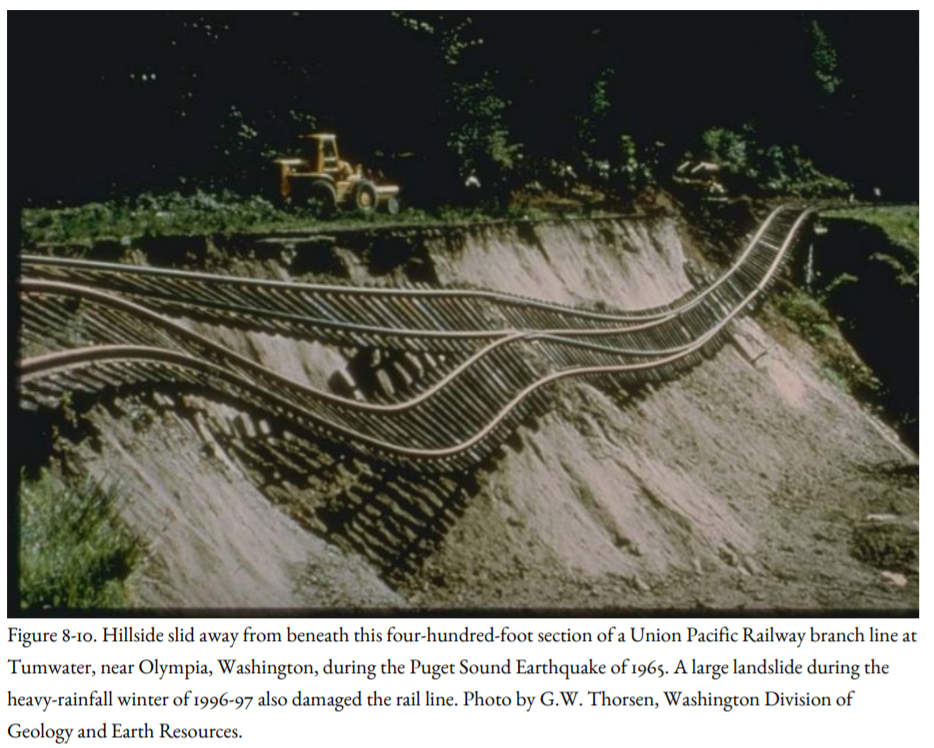
Earthquakes less than M 5.5 generate dozens of landslides, and earthquakes greater than M 8 generate thousands. The Northridge Earthquake triggered more than eleven thousand landslides, mostly in the mountains adjacent to the epicenter. The Puget Sound earthquakes of 1949 and 1965 triggered many landslides, including one that dislodged a railroad track near Tumwater, Washington (Figure 8-10). Landslides are particularly common in heavily forested areas of the Northwest, triggered by rainfall and by earthquakes.
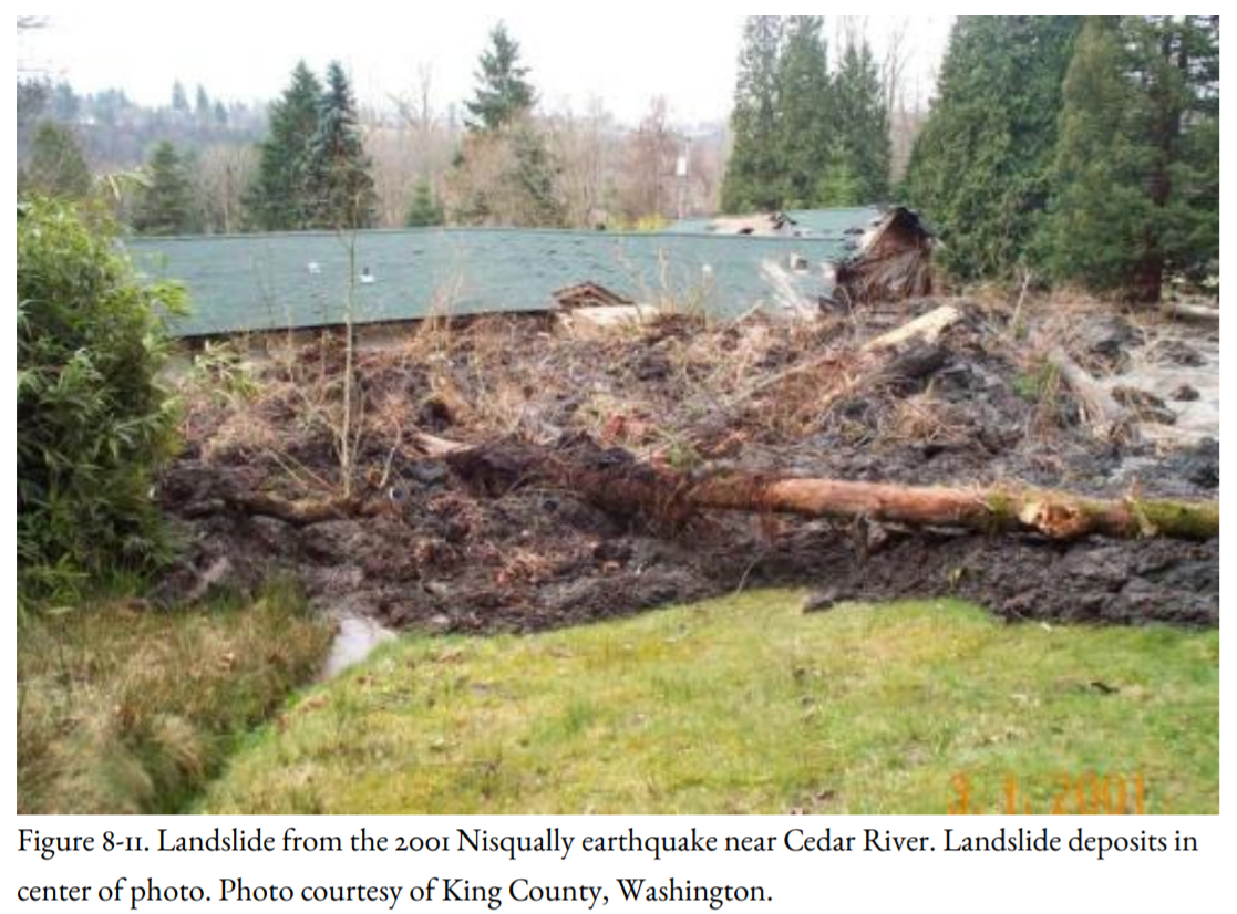
Paula Vandorssen of Renton, Washington, had been on the telephone when the Nisqually Earthquake hit. She quickly became aware that a massive wall of earth was pressing against the side of her house. Within a matter of seconds, mud and debris filled her living room. Paula stumbled onto her front porch and rolled down the hill as the slide pushed her house sideways. It was not quite eleven o’clock; a few minutes later, her five-year-old daughter would have been home, playing on the side of the house smashed by the slide. Other parts of the slide dammed the Cedar River (Figure 8-11), and more than one hundred families were evacuated as a lake began to form. Earth-moving equipment was quickly brought in to breach the mud dam.
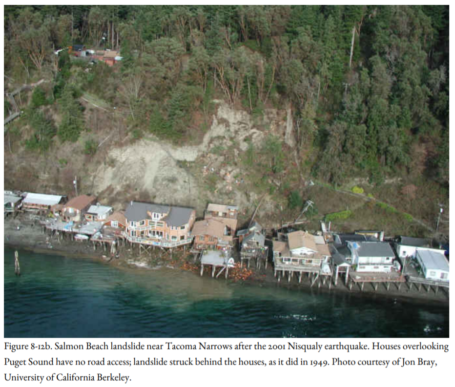
Salmon Beach lies along a bluff overlooking Puget Sound south of Point Defiance in Tacoma (Figure 8-12a, b). Its houses, with their magnificent views of the Sound and the Olympics, can be reached only by boat or by descending several hundred wooden steps from the road. The Nisqually Earthquake dislodged up to twenty thousand cubic feet of soil and debris; one large fir tree was pointed like a lance at the window of Luke and Alisa Xitco’s eighteen-month-old 4,600-square-foot cedar shake house. Eight houses were evacuated, several with serious damage. Luke Xitco declared that he was staying.
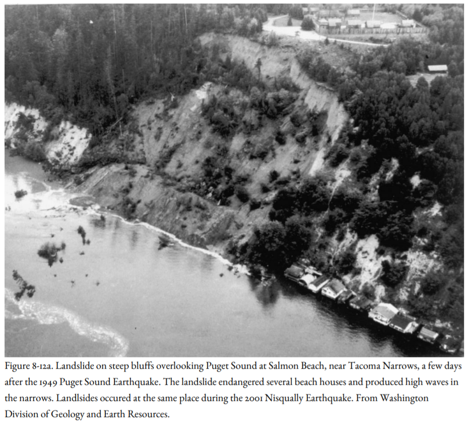
The Nisqually earthquake was not the first to heavily damage the homes at Salmon Beach. Similar damage was experienced during the earthquake of 1949 (Figure 8-12a).
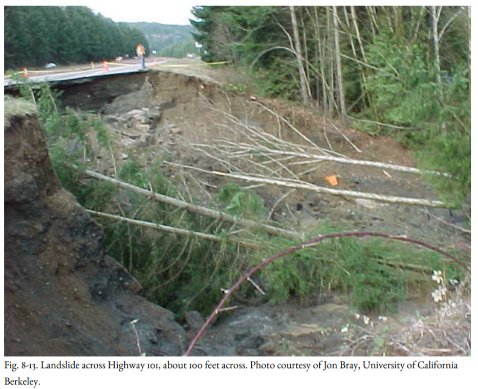
Fourteen homes on a bluff overlooking Puget Sound on Maplewood Avenue Southwest in Burien had to be evacuated (Figure 8-12b) after the Nisqually Earthquake when a foot-wide moat appeared between the road and the driveways. Other homes along the beach below were also evacuated, though some residents stayed despite the evacuation order. In addition to railroad damage (Figure 8-10), highways were also put out of service, as illustrated by Figure 8-13. Damage to highways caused delays in rescue operations and repair of damaged homes.
Some of the most common landslide types are rockfalls and rockslides. Although rockfalls might have a nonseismic origin, Bob Schuster of the USGS found that large rockfalls damming lakes on the eastern Olympic Peninsula of Washington (Figure 6-7) were most likely formed during a large earthquake eleven hundred years ago. No rockfalls as large as these are known from this area in historic time, which included earthquakes as large as M 7.1 as well as many severe winter storms.
Anyone who has hiked in the mountains has observed that many rocky talus slopes appear to be quite precarious, and seismic shaking can set these slopes in motion. John Muir, who experienced the 1872 Owens Valley Earthquake (M 7.7) in Yosemite Valley, described it best:
"At half-past two o’clock of a moonlit morning in March, I was awakened by a tremendous earthquake, and though I had never before enjoyed a storm of this sort, the strange thrilling motion could not be mistaken, and I ran out of my cabin, both glad and frightened, shouting, “A noble earthquake! A noble earthquake!” feeling sure I was going to learn something. The shocks were so violent and varied, and succeeding one another so closely, that I had to balance myself carefully in walking as if on the deck of a ship among waves, and it seemed impossible that the high cliffs of the Valley could escape being shattered. In particular, I feared that the sheer-fronted Sentinel Rock, towering above my cabin, would be shaken down, and I took shelter back of a large yellow pine, hoping that it might protect me from at least the smaller outerbounding boulders. For a minute or two, the shocks became more and more violent—flashing horizontal thrusts mixed with a few twists and battering, explosive, upheaving jolts,—as if Nature were wrecking her Yosemite temple, and getting ready to build a still better one.
I was now convinced before a single boulder had fallen that earthquakes were the talusmakers and positive proof soon came. It was a calm moonlight night, and no sound was heard for the first minute or so, save low, muffled, underground, bubbling rumblings, and the whispering and rustling of the agitated trees as if Nature were holding her breath. Then, suddenly, out of the strange silence and strange motion there came a tremendous roar. The Eagle Rock on the south wall, about a half a mile up the Valley, gave way and I saw it falling in thousands of the great boulders I had so long been studying, pouring to the Valley floor in a free curve luminous from friction, making a terribly sublime spectacle—an arc of glowing, passionate fire, fifteen hundred feet span, as true in form and as serene in beauty as a rainbow in the midst of the stupendous, roaring rock-storm. The sound was so tremendously deep and broad and earnest, the whole earth like a living creature seemed to have at last found a voice and to be calling to her sister planets. In trying to tell something of the size of this awful sound it seems to me that if all the thunder of all the storms I had ever heard were condensed into one roar it would not equal this rock-roar at the birth of a mountain talus."
The great landslides of Peru, Madison River, and Lituya Bay were rock avalanches, generally triggered by rockfalls at the time of the earthquake. Nearly all rockfalls are small, although locally damaging or deadly, like the one that killed Ken Campbell north of Klamath Falls, Oregon (Figure 6-24), and many have nonseismic origins like the Oso, Washington, landslide of March 2014. However, great rock avalanches seem to be unique to earthquakes, or earthquakes combined with volcanism, as in the huge avalanche that crashed into Spirit Lake and blocked the Toutle River during the Mt. St. Helens eruption of May 18, 1980. That avalanche was triggered by an earthquake of M 5.1, but both the avalanche and the earthquake might have been an effect of the eruption, which blew out the north side of the mountain.
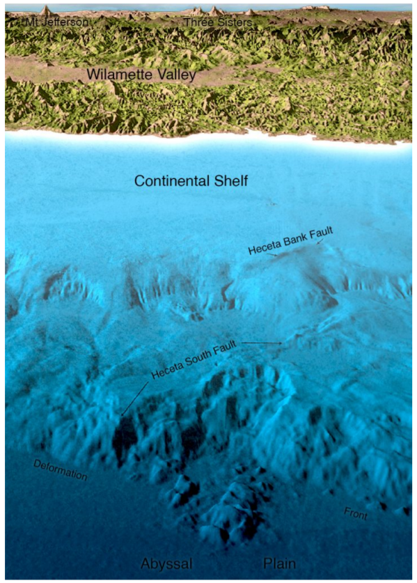
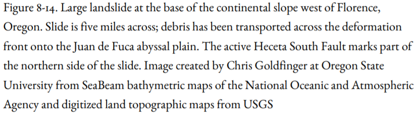
Landslides on the seafloor are an increasingly recognized phenomenon, principally because of the availability of side-scan sonar and new methods to map the topography of the seafloor. The continental slope off southern Oregon is largely composed of huge landslides, including the one illustrated in Figure 8-14 off Florence, Oregon. Chris Goldfinger mapped a landslide at the base of the continental slope off central Washington in which individual mountain-size blocks rode down onto the abyssal plain, leaving skid marks on the seafloor in their wake. These landslides are so large that it seems likely that they would generate huge sea waves, or tsunamis, as similar landslides have been shown to do in Hawaii and Papua New Guinea.
The Coast Range, Olympic Mountains, and the Cascades bear the scars of thousands of landslides that have been mapped by geologists. It cannot be demonstrated conclusively that these landslides have an earthquake origin, but certainly many of them do. Some of the smaller ones are slides or flows of soil material, which tend to be tongue-shaped or teardrop-shaped and to travel down gullies and steep canyons. Many of these form during a wet winter and are unrelated to earthquakes. David Keefer and Randy Jibson of the USGS summarize geotechnical evidence that suggests that some slides would not have been generated by wet weather during winter storms alone but would require seismic shaking to be set in motion. Geotechnical tests, such as the Standard Penetration Test, can be done in an evaluation of a building site on a hillside. Other geotechnical tests include measuring the shear strength of soils under both static (non-earthquake) and dynamic (earthquake) conditions.
The hills bordering the Willamette Valley contain numerous landslide deposits, particularly the West Hills of Portland. The Oregon Department of Geology and Mineral Industries has mapped these landslides using LiDAR, the same method used to map active faults in the Puget Sound region. Most of the Willamette Valley is covered by LiDAR, enabling landslides to be mapped. Most of Portland is covered with LiDAR-based maps locating these landslides. In my view, due diligence by the local government would require these governments to obtain LiDAR maps of their growing cities so that future development can be planned accordingly.
Two large Pacific Northwest landslides may not have had an earthquake origin. The Hope, B. C., landslide of 1965 was associated with an earthquake, but some people believe that the earthquake may have accompanied initial rupture of the shear surface marking the base of the landslide, and was not the cause of the slide. The Ribbon Cliffs rockslide, on the Columbia River north of Wenatchee, Washington, was reactivated by a large earthquake in 1872, as discussed in Chapter 6. Without direct observation, it is difficult to attribute large landslides in mountainous terrain to any earthquake, even when the earthquake occurred in historic time.
I close this section with a discussion of perhaps the most famous landslide in the Pacific Northwest, the Bonneville Landslide on the Columbia River near Cascade Locks (Figure 8-15). Volcanic rocks have been transported downslope on a thin sticky clay soil formed on top of one of the volcanic formations, forcing the Columbia River to its south bank and narrowing its width by half. The landslide has an area of at least thirteen square miles. It may have given rise to a Native American legend concerning the origin of the Bridge of the Gods. According to legend, the Bridge of the Gods was built by the Great Spirit to allow passage from one side of the river to the other. It was destroyed as a result of a great struggle between warriors now frozen in stone and ice as Mt. Klickitat (Mt. Adams) and Mt. Wyeast (Mt. Hood). A catastrophic landslide in prehistoric times could have dammed the Columbia and allowed people to walk from one side to the other until the river overtopped and cut out the dam. Radiocarbon dating by Pat Pringle, then of the Washington Division of Geology and Earth Resources and Bob Schuster of the USGS shows that this landslide could have come down during the great Cascadia Subduction Zone Earthquake of A.D. 1700.
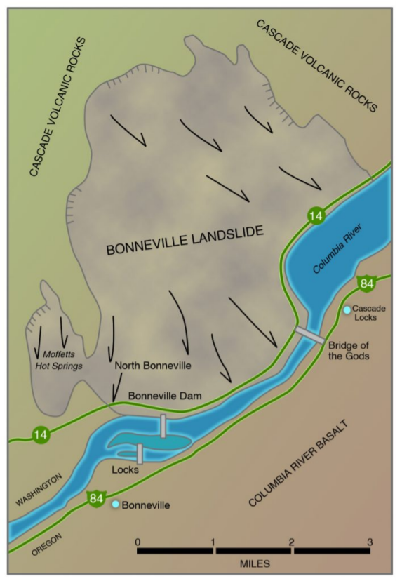
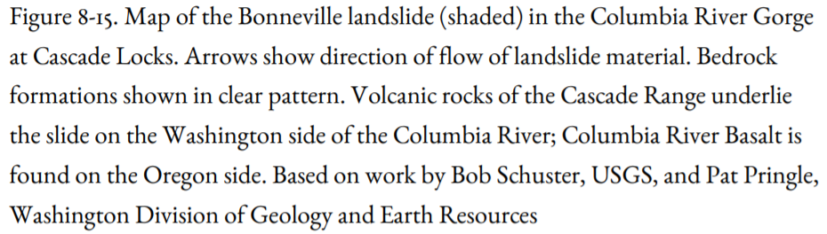
However, there is no direct evidence for an earthquake origin of the slide and no evidence that the slide came down all at once. Some of the slides coming down to the river from the Washington side are still active today. The Bonneville Landslide and the Bridge of the Gods remain a geological enigma.
As stated in a previous section, landslides are not strictly an earthquake-related phenomenon; they are a common side effect of winter storms as well. In evaluating a site for its landslide potential, Scott Burns of Portland State University uses a three-strike rule. Strike 1 is unstable soil, and strike 2 is a steep slope. Strike 3 may be either an earthquake or a heavy winter rainstorm that saturates the ground. By careful selection of building sites, strikes 1 and 2 can be avoided so that neither rainfall nor earthquake will cause a landslide.
Much of the loss of life-related to an earthquake is caused by landslides. In some cases, the slide mass moves slowly enough that people can get out of its way, but in rockfalls and rock avalanches, such as the large slides in Alaska, Peru, and Montana, and the rockfall witnessed by John Muir at Yosemite, the motion of the rock and soil mass is so quick that people are overwhelmed before they have an opportunity to get out of the way. This caused the loss of life from the Oso, Washington, landslide of March 2014.