12.4: Erosional Coastal Landforms (on Secondary Coastlines)
- Page ID
- 10335
\( \newcommand{\vecs}[1]{\overset { \scriptstyle \rightharpoonup} {\mathbf{#1}} } \)
\( \newcommand{\vecd}[1]{\overset{-\!-\!\rightharpoonup}{\vphantom{a}\smash {#1}}} \)
\( \newcommand{\id}{\mathrm{id}}\) \( \newcommand{\Span}{\mathrm{span}}\)
( \newcommand{\kernel}{\mathrm{null}\,}\) \( \newcommand{\range}{\mathrm{range}\,}\)
\( \newcommand{\RealPart}{\mathrm{Re}}\) \( \newcommand{\ImaginaryPart}{\mathrm{Im}}\)
\( \newcommand{\Argument}{\mathrm{Arg}}\) \( \newcommand{\norm}[1]{\| #1 \|}\)
\( \newcommand{\inner}[2]{\langle #1, #2 \rangle}\)
\( \newcommand{\Span}{\mathrm{span}}\)
\( \newcommand{\id}{\mathrm{id}}\)
\( \newcommand{\Span}{\mathrm{span}}\)
\( \newcommand{\kernel}{\mathrm{null}\,}\)
\( \newcommand{\range}{\mathrm{range}\,}\)
\( \newcommand{\RealPart}{\mathrm{Re}}\)
\( \newcommand{\ImaginaryPart}{\mathrm{Im}}\)
\( \newcommand{\Argument}{\mathrm{Arg}}\)
\( \newcommand{\norm}[1]{\| #1 \|}\)
\( \newcommand{\inner}[2]{\langle #1, #2 \rangle}\)
\( \newcommand{\Span}{\mathrm{span}}\) \( \newcommand{\AA}{\unicode[.8,0]{x212B}}\)
\( \newcommand{\vectorA}[1]{\vec{#1}} % arrow\)
\( \newcommand{\vectorAt}[1]{\vec{\text{#1}}} % arrow\)
\( \newcommand{\vectorB}[1]{\overset { \scriptstyle \rightharpoonup} {\mathbf{#1}} } \)
\( \newcommand{\vectorC}[1]{\textbf{#1}} \)
\( \newcommand{\vectorD}[1]{\overrightarrow{#1}} \)
\( \newcommand{\vectorDt}[1]{\overrightarrow{\text{#1}}} \)
\( \newcommand{\vectE}[1]{\overset{-\!-\!\rightharpoonup}{\vphantom{a}\smash{\mathbf {#1}}}} \)
\( \newcommand{\vecs}[1]{\overset { \scriptstyle \rightharpoonup} {\mathbf{#1}} } \)
\( \newcommand{\vecd}[1]{\overset{-\!-\!\rightharpoonup}{\vphantom{a}\smash {#1}}} \)
\(\newcommand{\avec}{\mathbf a}\) \(\newcommand{\bvec}{\mathbf b}\) \(\newcommand{\cvec}{\mathbf c}\) \(\newcommand{\dvec}{\mathbf d}\) \(\newcommand{\dtil}{\widetilde{\mathbf d}}\) \(\newcommand{\evec}{\mathbf e}\) \(\newcommand{\fvec}{\mathbf f}\) \(\newcommand{\nvec}{\mathbf n}\) \(\newcommand{\pvec}{\mathbf p}\) \(\newcommand{\qvec}{\mathbf q}\) \(\newcommand{\svec}{\mathbf s}\) \(\newcommand{\tvec}{\mathbf t}\) \(\newcommand{\uvec}{\mathbf u}\) \(\newcommand{\vvec}{\mathbf v}\) \(\newcommand{\wvec}{\mathbf w}\) \(\newcommand{\xvec}{\mathbf x}\) \(\newcommand{\yvec}{\mathbf y}\) \(\newcommand{\zvec}{\mathbf z}\) \(\newcommand{\rvec}{\mathbf r}\) \(\newcommand{\mvec}{\mathbf m}\) \(\newcommand{\zerovec}{\mathbf 0}\) \(\newcommand{\onevec}{\mathbf 1}\) \(\newcommand{\real}{\mathbb R}\) \(\newcommand{\twovec}[2]{\left[\begin{array}{r}#1 \\ #2 \end{array}\right]}\) \(\newcommand{\ctwovec}[2]{\left[\begin{array}{c}#1 \\ #2 \end{array}\right]}\) \(\newcommand{\threevec}[3]{\left[\begin{array}{r}#1 \\ #2 \\ #3 \end{array}\right]}\) \(\newcommand{\cthreevec}[3]{\left[\begin{array}{c}#1 \\ #2 \\ #3 \end{array}\right]}\) \(\newcommand{\fourvec}[4]{\left[\begin{array}{r}#1 \\ #2 \\ #3 \\ #4 \end{array}\right]}\) \(\newcommand{\cfourvec}[4]{\left[\begin{array}{c}#1 \\ #2 \\ #3 \\ #4 \end{array}\right]}\) \(\newcommand{\fivevec}[5]{\left[\begin{array}{r}#1 \\ #2 \\ #3 \\ #4 \\ #5 \\ \end{array}\right]}\) \(\newcommand{\cfivevec}[5]{\left[\begin{array}{c}#1 \\ #2 \\ #3 \\ #4 \\ #5 \\ \end{array}\right]}\) \(\newcommand{\mattwo}[4]{\left[\begin{array}{rr}#1 \amp #2 \\ #3 \amp #4 \\ \end{array}\right]}\) \(\newcommand{\laspan}[1]{\text{Span}\{#1\}}\) \(\newcommand{\bcal}{\cal B}\) \(\newcommand{\ccal}{\cal C}\) \(\newcommand{\scal}{\cal S}\) \(\newcommand{\wcal}{\cal W}\) \(\newcommand{\ecal}{\cal E}\) \(\newcommand{\coords}[2]{\left\{#1\right\}_{#2}}\) \(\newcommand{\gray}[1]{\color{gray}{#1}}\) \(\newcommand{\lgray}[1]{\color{lightgray}{#1}}\) \(\newcommand{\rank}{\operatorname{rank}}\) \(\newcommand{\row}{\text{Row}}\) \(\newcommand{\col}{\text{Col}}\) \(\renewcommand{\row}{\text{Row}}\) \(\newcommand{\nul}{\text{Nul}}\) \(\newcommand{\var}{\text{Var}}\) \(\newcommand{\corr}{\text{corr}}\) \(\newcommand{\len}[1]{\left|#1\right|}\) \(\newcommand{\bbar}{\overline{\bvec}}\) \(\newcommand{\bhat}{\widehat{\bvec}}\) \(\newcommand{\bperp}{\bvec^\perp}\) \(\newcommand{\xhat}{\widehat{\xvec}}\) \(\newcommand{\vhat}{\widehat{\vvec}}\) \(\newcommand{\uhat}{\widehat{\uvec}}\) \(\newcommand{\what}{\widehat{\wvec}}\) \(\newcommand{\Sighat}{\widehat{\Sigma}}\) \(\newcommand{\lt}{<}\) \(\newcommand{\gt}{>}\) \(\newcommand{\amp}{&}\) \(\definecolor{fillinmathshade}{gray}{0.9}\)Erosional Coastal Landforms or Features (on Secondary Coastlines)
Emergent coastlines typically have sea cliffs carved by wave and current action along the shoreline. The geometry of a coastline is largely a reflection of how some rocks along a coastline are more resistant to erosion.
Sea Cliffs and Wave-Cut Platforms
- Sea cliffs form where persistent wave erosion carves into elevated coastlines.
- Waves erode the base of cliff, causing it to subside or fail (Figure 12.13).
- Waves carve a flat surface where they scour the seabed leading up to the beach creating a wave-cut platform.
- When sea level locally falls falls (such as from uplift of a regional earthquake) wave action scours out a new wave-cut platform, leaving remnants of the old seabed surfaces exposed as expose wave-cut bench (Figure 12.14). A wave-cut bench is a flat bench-like platform of rock typically preserved in the upper surf zone associated with an actively eroding sea cliff on an emergent coastline (Figures 12-14 and 12-17, also see marine terraces below).
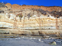
Figure 12.13. Sea cliff rise above the wave-cut platform (with beach) at Del Mar Dog Beach, CA
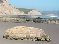
Figure 12.14. Wave-cut platform, wave-cut bench, and sea cliffs on Point Reyes National Seashore, CA
Headlands are rocky shorelines that have resisted wave erosion more than surrounding areas, forming points or small peninsulas that jut seaward. Small sandy beaches typically occur in bays between headlands (Figure 12.15).
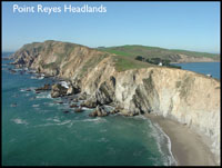
Sea stacks are large rocky outcrops that have resisted wave erosion and stand offshore as the beach and sea cliff continues to erode landward
- Mound of rock and debris that eventually is taken to sea by waves.
- The product of a sea arch caving in (Figure 12.16).
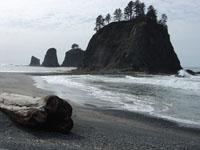
Figure 12.16. Sea stacks along the coast at Olympic National Park, WA
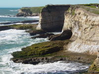
A sea cave is an underground passage or enclosed overhang carved into a sea cliff carved by focused wave action (Figure 12.17).
A sea arch is a natural rock arch caved by wave action. Sea arches form where two caves join together or where a cave cuts through a narrow fin of rock (Figure 12.18).
 |
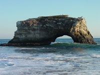 |
| Figure 12.17. A sea cave and wave-cut benches at Wilder Ranch State Park, Santa Cruz, CA. | Figure 12.18. A sea arch at Natural Bridges State Park, Santa Cruz, CA. |
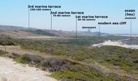
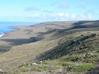
Marine terraces are elevated step-like benches formed by the combined effects of long-term wave erosion during the rise and fall of sea level on an emergent coastline (Figures 12-19 to 11-22). Marine terraces are old wave-cut platforms and benches that have been elevated by the land rising relative to the ocean surface.
Elevated marine terraces on the California coastline (examples in northern and southern California are illustrated in Figures 12-19 and 12-20).
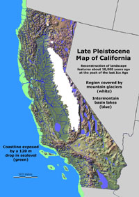
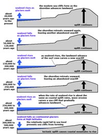
California preserves much evidence of geologic, geographic, and climatic changes caused by ice ages. During the last ice age, alpine glaciers and ice caps covered upland regions in the Sierra Nevada Range and Cascades volcanoes, but lower elevations were ice free (Figure 12.21). The formation of continental glaciers in North America and Europe caused sea level to fall almost 400 feet, causing the shoreline to migrate seaward as much as 10 to 70 miles (16 to 110 km) westward of the current coastline in some locations. This rise and fall of sea level happened with each glaciation cycle (of which there were many through the ice ages of the Pleistocene Epoch). In places where the California coastline is slowly rising, each of the major glaciation cycles is preserved as a step-like bench, called a marine terrace. The formation of marine terraces is illustrated in Figure 12.22.


