
10.14: Impact of Tsunamis in Modern World History
- Page ID
- 10318

\( \newcommand{\vecs}[1]{\overset { \scriptstyle \rightharpoonup} {\mathbf{#1}} } \)
\( \newcommand{\vecd}[1]{\overset{-\!-\!\rightharpoonup}{\vphantom{a}\smash {#1}}} \)
\( \newcommand{\id}{\mathrm{id}}\) \( \newcommand{\Span}{\mathrm{span}}\)
( \newcommand{\kernel}{\mathrm{null}\,}\) \( \newcommand{\range}{\mathrm{range}\,}\)
\( \newcommand{\RealPart}{\mathrm{Re}}\) \( \newcommand{\ImaginaryPart}{\mathrm{Im}}\)
\( \newcommand{\Argument}{\mathrm{Arg}}\) \( \newcommand{\norm}[1]{\| #1 \|}\)
\( \newcommand{\inner}[2]{\langle #1, #2 \rangle}\)
\( \newcommand{\Span}{\mathrm{span}}\)
\( \newcommand{\id}{\mathrm{id}}\)
\( \newcommand{\Span}{\mathrm{span}}\)
\( \newcommand{\kernel}{\mathrm{null}\,}\)
\( \newcommand{\range}{\mathrm{range}\,}\)
\( \newcommand{\RealPart}{\mathrm{Re}}\)
\( \newcommand{\ImaginaryPart}{\mathrm{Im}}\)
\( \newcommand{\Argument}{\mathrm{Arg}}\)
\( \newcommand{\norm}[1]{\| #1 \|}\)
\( \newcommand{\inner}[2]{\langle #1, #2 \rangle}\)
\( \newcommand{\Span}{\mathrm{span}}\) \( \newcommand{\AA}{\unicode[.8,0]{x212B}}\)
\( \newcommand{\vectorA}[1]{\vec{#1}} % arrow\)
\( \newcommand{\vectorAt}[1]{\vec{\text{#1}}} % arrow\)
\( \newcommand{\vectorB}[1]{\overset { \scriptstyle \rightharpoonup} {\mathbf{#1}} } \)
\( \newcommand{\vectorC}[1]{\textbf{#1}} \)
\( \newcommand{\vectorD}[1]{\overrightarrow{#1}} \)
\( \newcommand{\vectorDt}[1]{\overrightarrow{\text{#1}}} \)
\( \newcommand{\vectE}[1]{\overset{-\!-\!\rightharpoonup}{\vphantom{a}\smash{\mathbf {#1}}}} \)
\( \newcommand{\vecs}[1]{\overset { \scriptstyle \rightharpoonup} {\mathbf{#1}} } \)
\( \newcommand{\vecd}[1]{\overset{-\!-\!\rightharpoonup}{\vphantom{a}\smash {#1}}} \)
\(\newcommand{\avec}{\mathbf a}\) \(\newcommand{\bvec}{\mathbf b}\) \(\newcommand{\cvec}{\mathbf c}\) \(\newcommand{\dvec}{\mathbf d}\) \(\newcommand{\dtil}{\widetilde{\mathbf d}}\) \(\newcommand{\evec}{\mathbf e}\) \(\newcommand{\fvec}{\mathbf f}\) \(\newcommand{\nvec}{\mathbf n}\) \(\newcommand{\pvec}{\mathbf p}\) \(\newcommand{\qvec}{\mathbf q}\) \(\newcommand{\svec}{\mathbf s}\) \(\newcommand{\tvec}{\mathbf t}\) \(\newcommand{\uvec}{\mathbf u}\) \(\newcommand{\vvec}{\mathbf v}\) \(\newcommand{\wvec}{\mathbf w}\) \(\newcommand{\xvec}{\mathbf x}\) \(\newcommand{\yvec}{\mathbf y}\) \(\newcommand{\zvec}{\mathbf z}\) \(\newcommand{\rvec}{\mathbf r}\) \(\newcommand{\mvec}{\mathbf m}\) \(\newcommand{\zerovec}{\mathbf 0}\) \(\newcommand{\onevec}{\mathbf 1}\) \(\newcommand{\real}{\mathbb R}\) \(\newcommand{\twovec}[2]{\left[\begin{array}{r}#1 \\ #2 \end{array}\right]}\) \(\newcommand{\ctwovec}[2]{\left[\begin{array}{c}#1 \\ #2 \end{array}\right]}\) \(\newcommand{\threevec}[3]{\left[\begin{array}{r}#1 \\ #2 \\ #3 \end{array}\right]}\) \(\newcommand{\cthreevec}[3]{\left[\begin{array}{c}#1 \\ #2 \\ #3 \end{array}\right]}\) \(\newcommand{\fourvec}[4]{\left[\begin{array}{r}#1 \\ #2 \\ #3 \\ #4 \end{array}\right]}\) \(\newcommand{\cfourvec}[4]{\left[\begin{array}{c}#1 \\ #2 \\ #3 \\ #4 \end{array}\right]}\) \(\newcommand{\fivevec}[5]{\left[\begin{array}{r}#1 \\ #2 \\ #3 \\ #4 \\ #5 \\ \end{array}\right]}\) \(\newcommand{\cfivevec}[5]{\left[\begin{array}{c}#1 \\ #2 \\ #3 \\ #4 \\ #5 \\ \end{array}\right]}\) \(\newcommand{\mattwo}[4]{\left[\begin{array}{rr}#1 \amp #2 \\ #3 \amp #4 \\ \end{array}\right]}\) \(\newcommand{\laspan}[1]{\text{Span}\{#1\}}\) \(\newcommand{\bcal}{\cal B}\) \(\newcommand{\ccal}{\cal C}\) \(\newcommand{\scal}{\cal S}\) \(\newcommand{\wcal}{\cal W}\) \(\newcommand{\ecal}{\cal E}\) \(\newcommand{\coords}[2]{\left\{#1\right\}_{#2}}\) \(\newcommand{\gray}[1]{\color{gray}{#1}}\) \(\newcommand{\lgray}[1]{\color{lightgray}{#1}}\) \(\newcommand{\rank}{\operatorname{rank}}\) \(\newcommand{\row}{\text{Row}}\) \(\newcommand{\col}{\text{Col}}\) \(\renewcommand{\row}{\text{Row}}\) \(\newcommand{\nul}{\text{Nul}}\) \(\newcommand{\var}{\text{Var}}\) \(\newcommand{\corr}{\text{corr}}\) \(\newcommand{\len}[1]{\left|#1\right|}\) \(\newcommand{\bbar}{\overline{\bvec}}\) \(\newcommand{\bhat}{\widehat{\bvec}}\) \(\newcommand{\bperp}{\bvec^\perp}\) \(\newcommand{\xhat}{\widehat{\xvec}}\) \(\newcommand{\vhat}{\widehat{\vvec}}\) \(\newcommand{\uhat}{\widehat{\uvec}}\) \(\newcommand{\what}{\widehat{\wvec}}\) \(\newcommand{\Sighat}{\widehat{\Sigma}}\) \(\newcommand{\lt}{<}\) \(\newcommand{\gt}{>}\) \(\newcommand{\amp}{&}\) \(\definecolor{fillinmathshade}{gray}{0.9}\)Impact of Tsunamis in Modern World History
| Major Tsunami Events | Cause and Effects | Damages |
| Sumatra, Indonesia, 26 December 2004 |
The 9.1 magnitude earthquake offshore of Sumatra. The fault zone that caused the tsunami was roughly 800 miles (1300 km) long, vertically displacing the sea floor by several meters. | Tsunami was as tall as 50 m, reaching about 3 miles (5 km) inland. Many billions in damage, estimated 230,000 people killed. |
| North Pacific Coast, Japan, 11 March 2011 |
Tsunami was spawned by an 9.0 magnitude earthquake. Many coastal communities were destroyed and the Fukushima Daiichi nuclear power plant was damaged, releasing radiation | 10 m-high waves swept over the east coast of Japan, killing more than 18,000 people, Most expensive disaster in history: ~$235 billion. |
| Lisbon, Portugal, 1 November 1755 |
A magnitude 8.5 earthquake produced a series of three huge waves that struck various towns along the west coast of Portugal and Spain. Tsunami was up to 30 m high in some places | The earthquake and tsunami killed an estimated 60,000 people in the Portugal, Spain, and Morocco. |
| Krakatoa, Indonesia, 27 August 1883 |
This tsunami event was caused by explosive eruptions of the Krakatoa caldera volcano in the Sunda Strait between the islands of Java and Sumatra. Multiple waves as high as 37 m. | The event killed about 40,000 people in total; however, about 2,000 deaths were from the volcanic eruptions. |
| Enshunada Sea, Japan, 20 September 1498 | An earthquake estimated about magnitude 8.3, caused tsunami waves along the coasts of Izu, Kii, Mikawa, Sagami, and Surugu (Japan). | Coastal communities were washed away; estimated 31,000 people were killed. |
| Nankaido, Japan, 28 October 1707 |
A magnitude 8.4 earthquake caused tsunamis as high as 25 m that swept onto the Pacific coasts of Kyushyu, Shikoku and Honshin. | About 30,000 buildings were damaged and about 30,000 people were killed. |
|
Sanriku, Japan, |
An estimated magnitude 7.6 earthquake off the coast of Sanriku, Japan generated a tsunami reported to have reached a height of 38.2 m. | 11,000 homes destroyed and 22,000 people killed in Japan; 4,000 also killed in China. |
| Northern Chile, 13 August 1868 |
Earthquakes estimated at magnitude 8.5, off the coast of Africa, Peru (now Chile). Tsunamis affected entire Pacific Rim; waves reported up to 21 m high over two and three days. | Estimated 25,000 deaths and an $300 million in damages caused by the tsunamis and earthquakes along Peru-Chile coasts. |
| Ryuku Islands, Japan, 24 April 1771 |
A magnitude 7.4 earthquake produced a tsunami that damaged coastal communities on Ishigaki and Miyako Islands and others in the region. Tsunamis were 11 to 15 m high. | Tsunami destroyed 3,137 homes and about12,000 people were killed. |
| Ise Bay, Japan, 18 January 1586 |
An earthquake that caused a tsunami estimated to be about magnitude 8.2. The tsunamis rose to a height of 6 m. | Earthquake and following fired destroyed most of a city. 8000 people were killed. |
| Simple tsunami origin animation (NOAA) - How tsunamis form from an earthquake. Three Chile Tsunamis animation (PTWC) - Breakout animations of tsunamis of different intensities. |
 |
 |
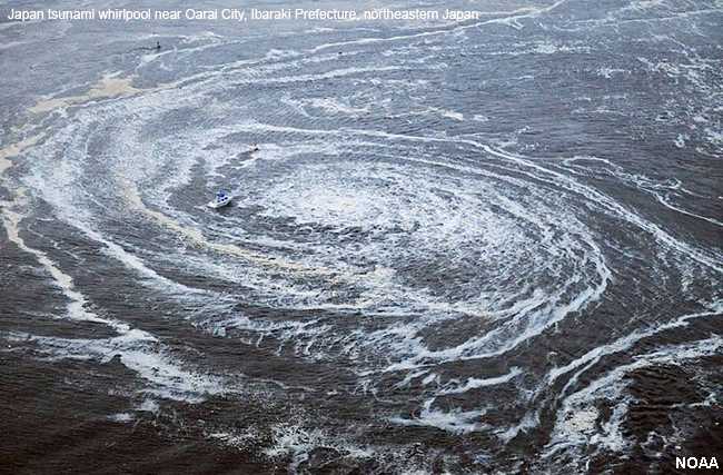 |
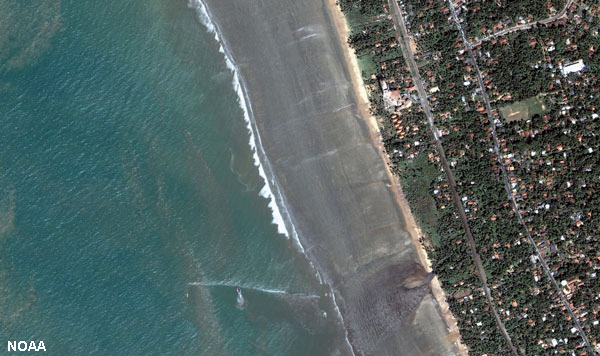
| Figure 10.34. Drawback from tsunami in Sri Lanka exposed about 150 meters before the tsunamis arrived from 2004 earthquake. | Figure 10.35. Tsunamis arriving on coast of Thailand, 2004 | Figure 10.36. Giant whirlpool caused by the Japan, 2011 tsunamis (note the boat for scale). |
 |
 |
 |
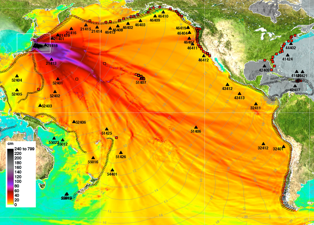 |
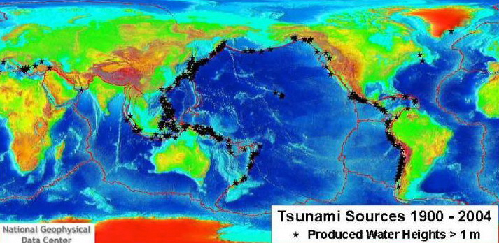
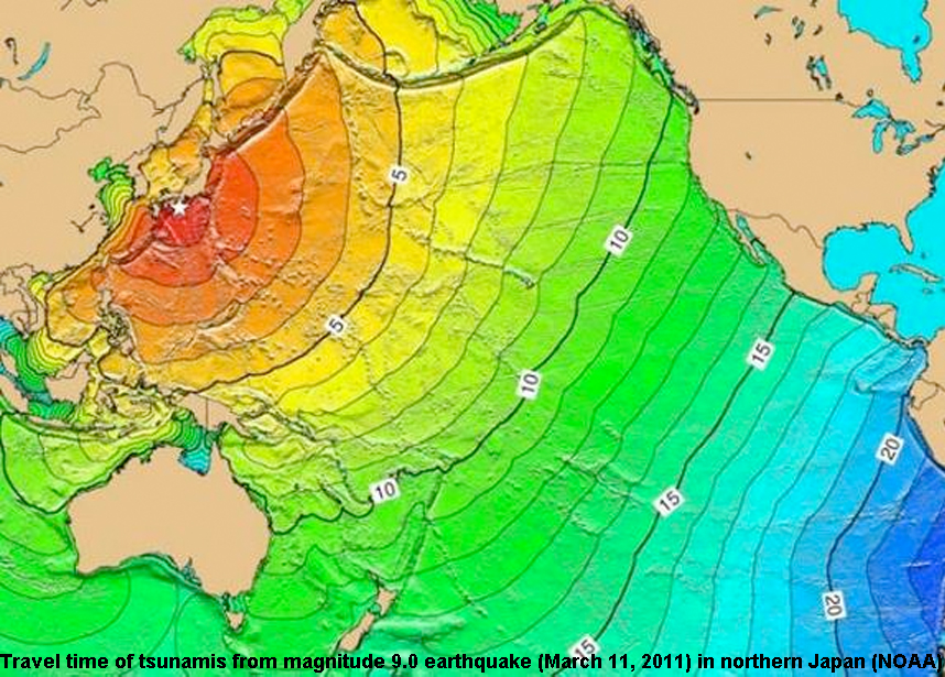
| Figure 10.37. Map showing locations of tsunami-generating earthquakes | Figure 10.38. Map of tsunami travel times generated by magnitude 9.5 earthquake Chili, 22 May, 1960. | Figure 10.39. Map of tsunami travel time from magnitude 9.0 earthquake in northern Japan, 11 March 2011 | Figure 10.40. Maximum wave amplitude of tsunami from northern Japan, 11 March 2011 |
| Tsunami Damage from the 2004 Sumatra tsunami | |||
 |
 |
 |
 |
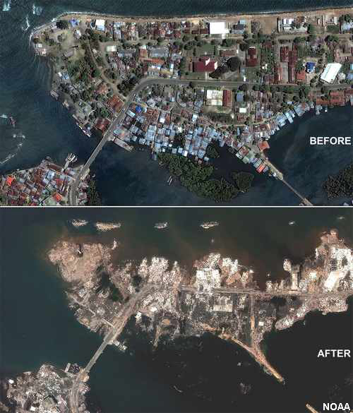
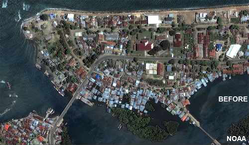
| Figure 10.41. Banda Aceh, Indonesia before 2004 tsunami |
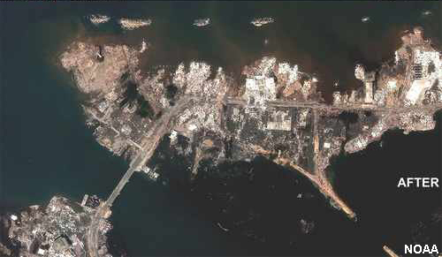
Figure 10.42. Banda Aceh, Indonesia after 2004 tsunami |
Figure 10.43. Mosque survived 2004 tsunami in Banda Aceh, Sumatra |
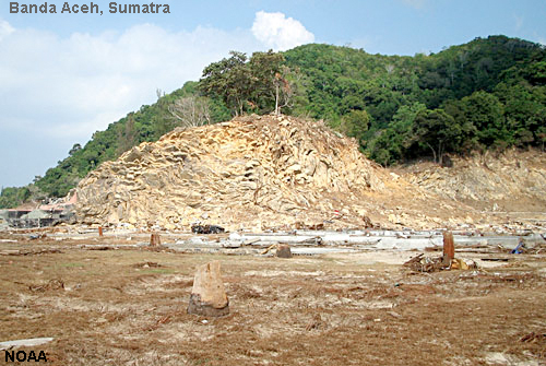
Figure 10.44. Vegetation stripped from hillsides by run up: Banda Aceh, Sumatra tsunami 2004 |
| Examples of Tsunami Damage | |||
 |
 |
 |
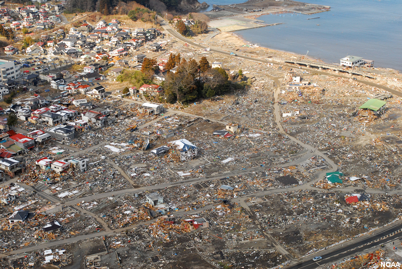 |
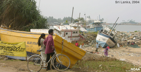
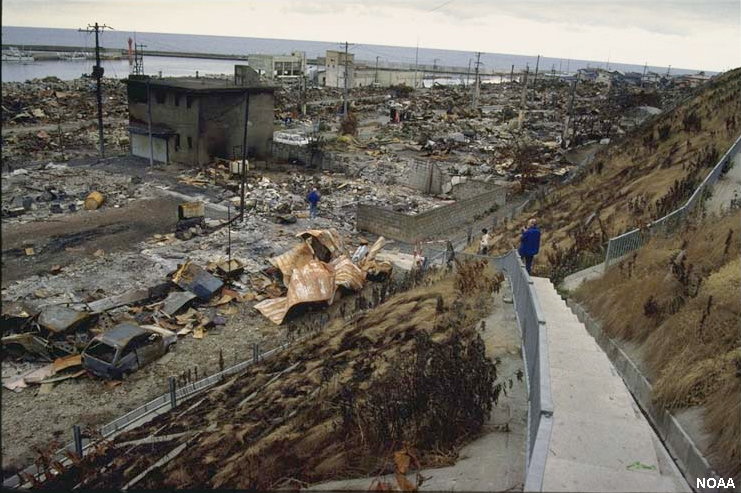
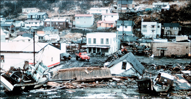
| Figure 10.45. The Sumatra 2004 earthquake caused damage in Sri Lanka 2,000 miles away. | Figure 10.46. Damage from the Tsunami of July 12, 1993, a magnitude 7.6 in the Sea of Japan near Hokkaido. The tsunami was 32 meters high on Okishuri, Island. | Figure 10.47. Tsunami damage in Kodiak, Alaska from the March 27,1964 earthquake (magnitude 9.2) | Figure 10.48. March 11, 2011 Tohoku Japan earthquake and tsunami |
| Tsunami Warning System | |||
 |
 |
 |
Everything you ever wanted to know about tsunamis, and more: Pacific Tsunami Warning Center website. Learn about: Tsunami Paleogeohistory of San Diego County |
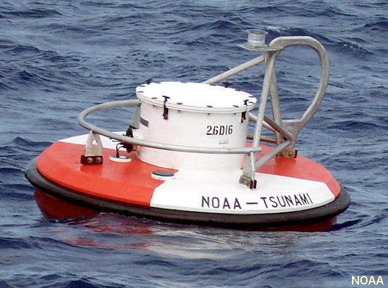
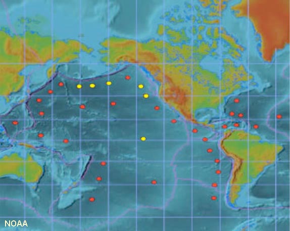
| Figure 10.49 & 50. DART Buoy and DART tsunami warning system (left). | Figure 10.51. Location of tsunami warning system buoys around Pacific and Atlantic basins. | ||
Tsunami videos (as of July, 2019)
Indonesia Tsunami 2004 (NOAA): Tsunami waves move out animation of Indian Ocean
Japanese 2011 Tsunami caught on CCTV: YouTube video
Incredible TSUNAMI in Kamaishi City - Complete Edition (Japan)
https://www.youtube.com/watch?v=uRyM1ujSwrM
Thailand Tsunamis 2004, raw footage: https://www.youtube.com/watch?v=a7WyJ4S1Pdc
Helicopter view of Japan 2011 tsunamis: YouTube video
Scale of the TSUNAMI Power - Educating Document: https://www.youtube.com/watch?v=_eh5aq_GeUY
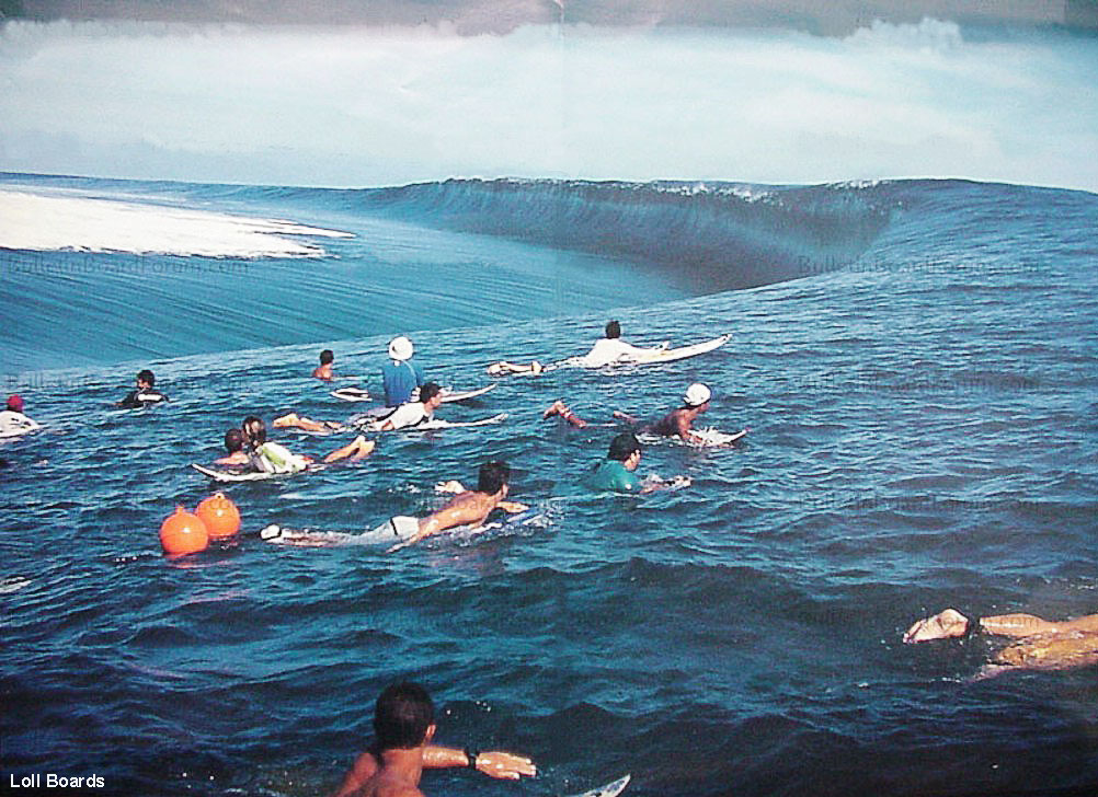
Figure 10.52. Surfing a tsunami wave? (Not recommended!)