
8.13: The Coriolis Effect Influences Superstorms
- Page ID
- 10274

\( \newcommand{\vecs}[1]{\overset { \scriptstyle \rightharpoonup} {\mathbf{#1}} } \)
\( \newcommand{\vecd}[1]{\overset{-\!-\!\rightharpoonup}{\vphantom{a}\smash {#1}}} \)
\( \newcommand{\id}{\mathrm{id}}\) \( \newcommand{\Span}{\mathrm{span}}\)
( \newcommand{\kernel}{\mathrm{null}\,}\) \( \newcommand{\range}{\mathrm{range}\,}\)
\( \newcommand{\RealPart}{\mathrm{Re}}\) \( \newcommand{\ImaginaryPart}{\mathrm{Im}}\)
\( \newcommand{\Argument}{\mathrm{Arg}}\) \( \newcommand{\norm}[1]{\| #1 \|}\)
\( \newcommand{\inner}[2]{\langle #1, #2 \rangle}\)
\( \newcommand{\Span}{\mathrm{span}}\)
\( \newcommand{\id}{\mathrm{id}}\)
\( \newcommand{\Span}{\mathrm{span}}\)
\( \newcommand{\kernel}{\mathrm{null}\,}\)
\( \newcommand{\range}{\mathrm{range}\,}\)
\( \newcommand{\RealPart}{\mathrm{Re}}\)
\( \newcommand{\ImaginaryPart}{\mathrm{Im}}\)
\( \newcommand{\Argument}{\mathrm{Arg}}\)
\( \newcommand{\norm}[1]{\| #1 \|}\)
\( \newcommand{\inner}[2]{\langle #1, #2 \rangle}\)
\( \newcommand{\Span}{\mathrm{span}}\) \( \newcommand{\AA}{\unicode[.8,0]{x212B}}\)
\( \newcommand{\vectorA}[1]{\vec{#1}} % arrow\)
\( \newcommand{\vectorAt}[1]{\vec{\text{#1}}} % arrow\)
\( \newcommand{\vectorB}[1]{\overset { \scriptstyle \rightharpoonup} {\mathbf{#1}} } \)
\( \newcommand{\vectorC}[1]{\textbf{#1}} \)
\( \newcommand{\vectorD}[1]{\overrightarrow{#1}} \)
\( \newcommand{\vectorDt}[1]{\overrightarrow{\text{#1}}} \)
\( \newcommand{\vectE}[1]{\overset{-\!-\!\rightharpoonup}{\vphantom{a}\smash{\mathbf {#1}}}} \)
\( \newcommand{\vecs}[1]{\overset { \scriptstyle \rightharpoonup} {\mathbf{#1}} } \)
\( \newcommand{\vecd}[1]{\overset{-\!-\!\rightharpoonup}{\vphantom{a}\smash {#1}}} \)
\(\newcommand{\avec}{\mathbf a}\) \(\newcommand{\bvec}{\mathbf b}\) \(\newcommand{\cvec}{\mathbf c}\) \(\newcommand{\dvec}{\mathbf d}\) \(\newcommand{\dtil}{\widetilde{\mathbf d}}\) \(\newcommand{\evec}{\mathbf e}\) \(\newcommand{\fvec}{\mathbf f}\) \(\newcommand{\nvec}{\mathbf n}\) \(\newcommand{\pvec}{\mathbf p}\) \(\newcommand{\qvec}{\mathbf q}\) \(\newcommand{\svec}{\mathbf s}\) \(\newcommand{\tvec}{\mathbf t}\) \(\newcommand{\uvec}{\mathbf u}\) \(\newcommand{\vvec}{\mathbf v}\) \(\newcommand{\wvec}{\mathbf w}\) \(\newcommand{\xvec}{\mathbf x}\) \(\newcommand{\yvec}{\mathbf y}\) \(\newcommand{\zvec}{\mathbf z}\) \(\newcommand{\rvec}{\mathbf r}\) \(\newcommand{\mvec}{\mathbf m}\) \(\newcommand{\zerovec}{\mathbf 0}\) \(\newcommand{\onevec}{\mathbf 1}\) \(\newcommand{\real}{\mathbb R}\) \(\newcommand{\twovec}[2]{\left[\begin{array}{r}#1 \\ #2 \end{array}\right]}\) \(\newcommand{\ctwovec}[2]{\left[\begin{array}{c}#1 \\ #2 \end{array}\right]}\) \(\newcommand{\threevec}[3]{\left[\begin{array}{r}#1 \\ #2 \\ #3 \end{array}\right]}\) \(\newcommand{\cthreevec}[3]{\left[\begin{array}{c}#1 \\ #2 \\ #3 \end{array}\right]}\) \(\newcommand{\fourvec}[4]{\left[\begin{array}{r}#1 \\ #2 \\ #3 \\ #4 \end{array}\right]}\) \(\newcommand{\cfourvec}[4]{\left[\begin{array}{c}#1 \\ #2 \\ #3 \\ #4 \end{array}\right]}\) \(\newcommand{\fivevec}[5]{\left[\begin{array}{r}#1 \\ #2 \\ #3 \\ #4 \\ #5 \\ \end{array}\right]}\) \(\newcommand{\cfivevec}[5]{\left[\begin{array}{c}#1 \\ #2 \\ #3 \\ #4 \\ #5 \\ \end{array}\right]}\) \(\newcommand{\mattwo}[4]{\left[\begin{array}{rr}#1 \amp #2 \\ #3 \amp #4 \\ \end{array}\right]}\) \(\newcommand{\laspan}[1]{\text{Span}\{#1\}}\) \(\newcommand{\bcal}{\cal B}\) \(\newcommand{\ccal}{\cal C}\) \(\newcommand{\scal}{\cal S}\) \(\newcommand{\wcal}{\cal W}\) \(\newcommand{\ecal}{\cal E}\) \(\newcommand{\coords}[2]{\left\{#1\right\}_{#2}}\) \(\newcommand{\gray}[1]{\color{gray}{#1}}\) \(\newcommand{\lgray}[1]{\color{lightgray}{#1}}\) \(\newcommand{\rank}{\operatorname{rank}}\) \(\newcommand{\row}{\text{Row}}\) \(\newcommand{\col}{\text{Col}}\) \(\renewcommand{\row}{\text{Row}}\) \(\newcommand{\nul}{\text{Nul}}\) \(\newcommand{\var}{\text{Var}}\) \(\newcommand{\corr}{\text{corr}}\) \(\newcommand{\len}[1]{\left|#1\right|}\) \(\newcommand{\bbar}{\overline{\bvec}}\) \(\newcommand{\bhat}{\widehat{\bvec}}\) \(\newcommand{\bperp}{\bvec^\perp}\) \(\newcommand{\xhat}{\widehat{\xvec}}\) \(\newcommand{\vhat}{\widehat{\vvec}}\) \(\newcommand{\uhat}{\widehat{\uvec}}\) \(\newcommand{\what}{\widehat{\wvec}}\) \(\newcommand{\Sighat}{\widehat{\Sigma}}\) \(\newcommand{\lt}{<}\) \(\newcommand{\gt}{>}\) \(\newcommand{\amp}{&}\) \(\definecolor{fillinmathshade}{gray}{0.9}\)The Coriolis Effect Influences Superstorms
Large rotating storms are called hurricanes (near North America), typhoons (near Southeast Asia) and cyclones (in the Indian Ocean). All are the same, caused by warm moist winds being drawn to the center of low pressure near the center of the storm (called the eye in well developed storms). North of the equator the Coriolis effect causes low-atmospheric pressure to rotate counterclockwise, but south of the equator they rotate in a clockwise direction. The lower the air pressure in the eye of the storm, the greater the wind speed and rotation. Note on the map in Figure 8.36 that there are no hurricanes along the equator or near the poles. These are regions where the Coriolis effect is not a significant force in deflecting storm winds to cause rotation.
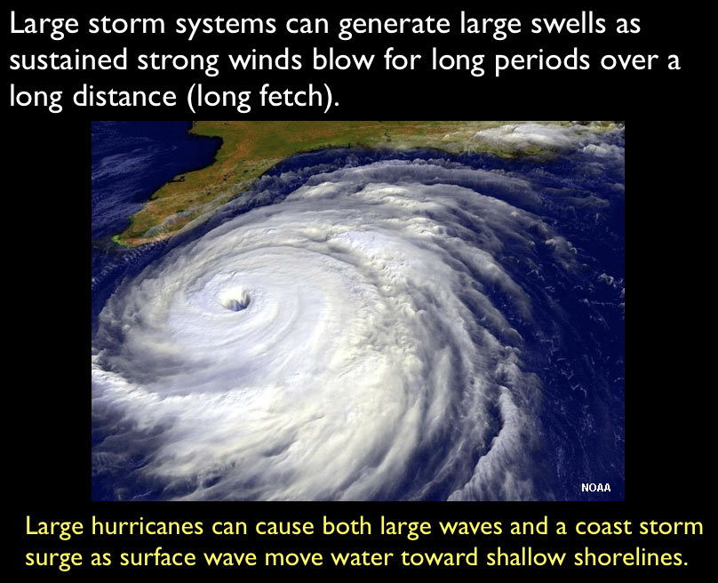
Superstorms not only can cause major wind damage and flooding, but can erode and redeposit vast quantities of sediments, both offshore and onshore, heavily impacting impacting both communities and ecosystems.
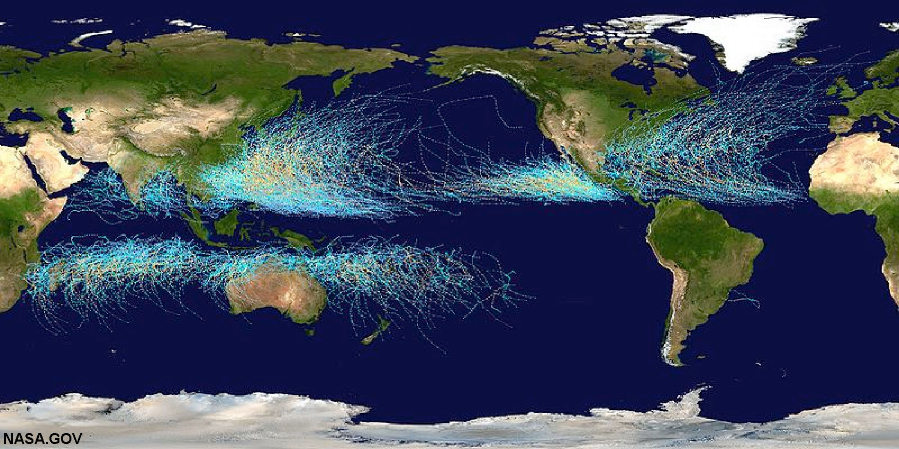
Fig.5-36. World map showing historic paths of hurricanes, typhoons, and cyclones. The large storms are the same (different names for different regions); storm rotation is influenced by the Coriolis effect.
Tropical Cyclones, Hurricanes, and Typhoons
Tropical cyclones are large rotating air masses with low atmospheric pressure (Figures 8-37 and 8-38).
Tropical cyclones are called hurricanes in the Atlantic Ocean or in the Pacific near North or South America, and Hawaii). Tropical cyclones are called typhoons in the Western Pacific Ocean region. They are simply called cyclones in the Indian Ocean region.
Northern Hemisphere Example:
• Storms Intensify over warm water (>77 degrees F); warm water provides water vapor.
• Water vapor provides fuel for storm in the form of latent heat energy as water vapor condenses.
• Storms die over land and cool water.
• High winds, tornadoes occur near storm center and along feeder bands.
• Sea level can rise in front of storm called a storm surge.
• Classified by maximum sustained wind speed (see rating storms below).
• Hurricanes and other storms rotate counterclockwise in the Northern Hemisphere because of the Coriolis effect.
 |
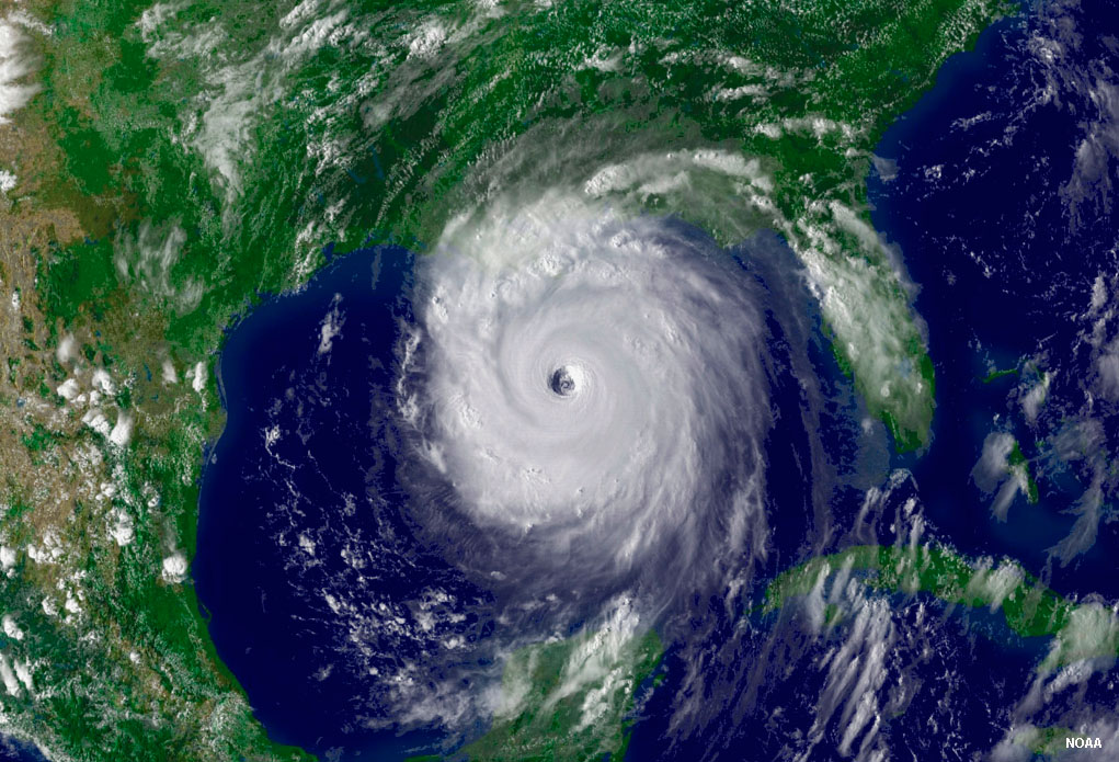 |
| Figure 8.37. Hurricane Andrew (1992) was for a time a Category 5 hurricane with sustained winds of 175 mph (280 km/hr). | Figure 8.38. The eye of a hurricane is the center of low pressure. Hurricane Katrina (2005) shown here, was the most costly and destructive hurricane disaster in US history, killing more than 1,800 people. |
Ratings Storms (By Maximum Sustained Wind Speed)
• Tropical depression (<38 mph)
• Tropical storm (between 38 and 74 mph)
• Tropical cyclone (>74 mph)
Saffir-Simpson Scale: 5 categories of hurricane intensity based upon wind speed (see NOAA website)
• Category 1 is from 74 to 96 mph.
• Category 2 is from 96 to 110 mph.
• Category 3 is from 111 to 130 mph - level considered a "superstorm" (Katrina, 2005).
• Category 4 is from 130 to 155 mph (examples: Andrew, 1992, Hugo, 1989).
• Category 5 is >155 mph (Camille, 1969).
Naming storms: Alphabetical lists of names are assigned each year to storms that develop in each of the ocean basins. Names of notoriously damaging storms are retired to remind people of their impacts and legacy.
The term superstorm is used to describe any powerful and destructive storm that affects a large area or region. Tropical storms and cyclones can be superstorms, but other massive storms in temperate and polar regions can be become superstorms. Nor'easters are extra-tropical superstorms that typically impact the Northeastern United States in the fall and winter season, causing massive amounts of snowfall and coastal flooding.