
8.9: Weather
- Page ID
- 10270

\( \newcommand{\vecs}[1]{\overset { \scriptstyle \rightharpoonup} {\mathbf{#1}} } \)
\( \newcommand{\vecd}[1]{\overset{-\!-\!\rightharpoonup}{\vphantom{a}\smash {#1}}} \)
\( \newcommand{\dsum}{\displaystyle\sum\limits} \)
\( \newcommand{\dint}{\displaystyle\int\limits} \)
\( \newcommand{\dlim}{\displaystyle\lim\limits} \)
\( \newcommand{\id}{\mathrm{id}}\) \( \newcommand{\Span}{\mathrm{span}}\)
( \newcommand{\kernel}{\mathrm{null}\,}\) \( \newcommand{\range}{\mathrm{range}\,}\)
\( \newcommand{\RealPart}{\mathrm{Re}}\) \( \newcommand{\ImaginaryPart}{\mathrm{Im}}\)
\( \newcommand{\Argument}{\mathrm{Arg}}\) \( \newcommand{\norm}[1]{\| #1 \|}\)
\( \newcommand{\inner}[2]{\langle #1, #2 \rangle}\)
\( \newcommand{\Span}{\mathrm{span}}\)
\( \newcommand{\id}{\mathrm{id}}\)
\( \newcommand{\Span}{\mathrm{span}}\)
\( \newcommand{\kernel}{\mathrm{null}\,}\)
\( \newcommand{\range}{\mathrm{range}\,}\)
\( \newcommand{\RealPart}{\mathrm{Re}}\)
\( \newcommand{\ImaginaryPart}{\mathrm{Im}}\)
\( \newcommand{\Argument}{\mathrm{Arg}}\)
\( \newcommand{\norm}[1]{\| #1 \|}\)
\( \newcommand{\inner}[2]{\langle #1, #2 \rangle}\)
\( \newcommand{\Span}{\mathrm{span}}\) \( \newcommand{\AA}{\unicode[.8,0]{x212B}}\)
\( \newcommand{\vectorA}[1]{\vec{#1}} % arrow\)
\( \newcommand{\vectorAt}[1]{\vec{\text{#1}}} % arrow\)
\( \newcommand{\vectorB}[1]{\overset { \scriptstyle \rightharpoonup} {\mathbf{#1}} } \)
\( \newcommand{\vectorC}[1]{\textbf{#1}} \)
\( \newcommand{\vectorD}[1]{\overrightarrow{#1}} \)
\( \newcommand{\vectorDt}[1]{\overrightarrow{\text{#1}}} \)
\( \newcommand{\vectE}[1]{\overset{-\!-\!\rightharpoonup}{\vphantom{a}\smash{\mathbf {#1}}}} \)
\( \newcommand{\vecs}[1]{\overset { \scriptstyle \rightharpoonup} {\mathbf{#1}} } \)
\(\newcommand{\longvect}{\overrightarrow}\)
\( \newcommand{\vecd}[1]{\overset{-\!-\!\rightharpoonup}{\vphantom{a}\smash {#1}}} \)
\(\newcommand{\avec}{\mathbf a}\) \(\newcommand{\bvec}{\mathbf b}\) \(\newcommand{\cvec}{\mathbf c}\) \(\newcommand{\dvec}{\mathbf d}\) \(\newcommand{\dtil}{\widetilde{\mathbf d}}\) \(\newcommand{\evec}{\mathbf e}\) \(\newcommand{\fvec}{\mathbf f}\) \(\newcommand{\nvec}{\mathbf n}\) \(\newcommand{\pvec}{\mathbf p}\) \(\newcommand{\qvec}{\mathbf q}\) \(\newcommand{\svec}{\mathbf s}\) \(\newcommand{\tvec}{\mathbf t}\) \(\newcommand{\uvec}{\mathbf u}\) \(\newcommand{\vvec}{\mathbf v}\) \(\newcommand{\wvec}{\mathbf w}\) \(\newcommand{\xvec}{\mathbf x}\) \(\newcommand{\yvec}{\mathbf y}\) \(\newcommand{\zvec}{\mathbf z}\) \(\newcommand{\rvec}{\mathbf r}\) \(\newcommand{\mvec}{\mathbf m}\) \(\newcommand{\zerovec}{\mathbf 0}\) \(\newcommand{\onevec}{\mathbf 1}\) \(\newcommand{\real}{\mathbb R}\) \(\newcommand{\twovec}[2]{\left[\begin{array}{r}#1 \\ #2 \end{array}\right]}\) \(\newcommand{\ctwovec}[2]{\left[\begin{array}{c}#1 \\ #2 \end{array}\right]}\) \(\newcommand{\threevec}[3]{\left[\begin{array}{r}#1 \\ #2 \\ #3 \end{array}\right]}\) \(\newcommand{\cthreevec}[3]{\left[\begin{array}{c}#1 \\ #2 \\ #3 \end{array}\right]}\) \(\newcommand{\fourvec}[4]{\left[\begin{array}{r}#1 \\ #2 \\ #3 \\ #4 \end{array}\right]}\) \(\newcommand{\cfourvec}[4]{\left[\begin{array}{c}#1 \\ #2 \\ #3 \\ #4 \end{array}\right]}\) \(\newcommand{\fivevec}[5]{\left[\begin{array}{r}#1 \\ #2 \\ #3 \\ #4 \\ #5 \\ \end{array}\right]}\) \(\newcommand{\cfivevec}[5]{\left[\begin{array}{c}#1 \\ #2 \\ #3 \\ #4 \\ #5 \\ \end{array}\right]}\) \(\newcommand{\mattwo}[4]{\left[\begin{array}{rr}#1 \amp #2 \\ #3 \amp #4 \\ \end{array}\right]}\) \(\newcommand{\laspan}[1]{\text{Span}\{#1\}}\) \(\newcommand{\bcal}{\cal B}\) \(\newcommand{\ccal}{\cal C}\) \(\newcommand{\scal}{\cal S}\) \(\newcommand{\wcal}{\cal W}\) \(\newcommand{\ecal}{\cal E}\) \(\newcommand{\coords}[2]{\left\{#1\right\}_{#2}}\) \(\newcommand{\gray}[1]{\color{gray}{#1}}\) \(\newcommand{\lgray}[1]{\color{lightgray}{#1}}\) \(\newcommand{\rank}{\operatorname{rank}}\) \(\newcommand{\row}{\text{Row}}\) \(\newcommand{\col}{\text{Col}}\) \(\renewcommand{\row}{\text{Row}}\) \(\newcommand{\nul}{\text{Nul}}\) \(\newcommand{\var}{\text{Var}}\) \(\newcommand{\corr}{\text{corr}}\) \(\newcommand{\len}[1]{\left|#1\right|}\) \(\newcommand{\bbar}{\overline{\bvec}}\) \(\newcommand{\bhat}{\widehat{\bvec}}\) \(\newcommand{\bperp}{\bvec^\perp}\) \(\newcommand{\xhat}{\widehat{\xvec}}\) \(\newcommand{\vhat}{\widehat{\vvec}}\) \(\newcommand{\uhat}{\widehat{\uvec}}\) \(\newcommand{\what}{\widehat{\wvec}}\) \(\newcommand{\Sighat}{\widehat{\Sigma}}\) \(\newcommand{\lt}{<}\) \(\newcommand{\gt}{>}\) \(\newcommand{\amp}{&}\) \(\definecolor{fillinmathshade}{gray}{0.9}\)Weather is the state of the atmosphere at any place and time in regards to conditions: sunshine, heat, dryness, cloud cover, wind, precipitation (rain, sleet, snow, hail), etc.
Clouds
Clouds form when the invisible water vapor in the air condenses into visible water droplets or ice crystals.
The dew point is when the relative humidity reaches 100%. The base of a cloud marks the boundary where relative humidity has reached saturation. Cloud tops can rise until they encounter warmer air in the stratosphere. There they stop rising and spread out forming anvil-shaped thunderheads shapes (Figure 8.19).
4 general types of clouds (there are many sub-types)
Cirro-form: high level, wispy - fair weather clouds if ice crystals, typically above 20,000 ft (6000 m)
Cumulo-form: low to high level cotton-like puffy clouds with flat base at 100% humidity level, can rise to 60,000 feet.
Nimbo-form: rain clouds (low to mid level) - clouds typical thicken and lower as precipitation begins.
Strato-form. uniform flat cloud layer at any level, forms fog at the surface (coastal marine layer an example)
Names of clouds can include combinations of forms as they change. For instance, a small, puffy white cumulus cloud can build up and become an altocumulus cloud, before rising even further to become a cumulonimbus (thunderstorm) that can develop a high avil-shaped top as the rising moist air at top the cloud encounters the stratosphere and can't rise any higher.
Figure 8.20 illustrates common forms of clouds. Also see Types of Clouds (NOAA National Weather Services - Image gallery of clouds and cloud-related phenomena).
 |
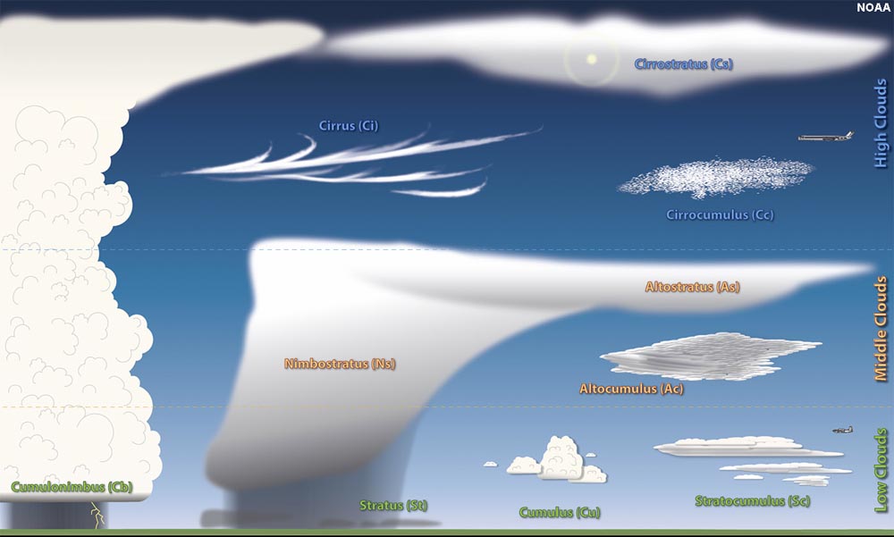 |
| Figure 8.19. Cloud base and tops of a thunderstorm (a cumulonimbus cloud). | Figure 8.20. Common types of clouds. |
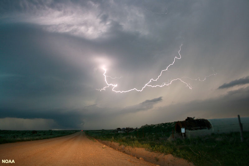
Lightning and Thunder
Lightning is giant spark, or series of sparks (electrical discharges), that leap through the air.
Lighting occurs as mostly as intra-cloud lightning (leaping between different parts of a thunderstorm, Figure 8.21) or cloud-to-ground lightning (Figure 8.22). Lightning is caused by the buildup of between positive and negative electrostatic charges within the clouds or between the clouds and the ground. The air acts as an insulator between the buildup of charges until they become great enough to overpower the insulating capacity of the air.
 |
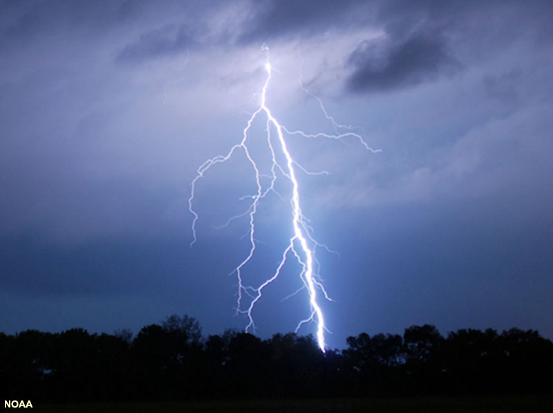 |
| Figure 8.21. Intra-cloud lightning. | Figure 8.22. Sky-to-ground lightning with leader bands. |
The passage of lightning has jagged path. Lightning probably follows the interconnect paths created by ionizing radiation particles passing through the atmosphere from outer space. These particle create very short-lived plasma passages through the atmosphere that allow electricity to propagate through the insulating air, creating the rapid electrified flashes we see as lightning. The discharge of lightning temporarily equalizes the charged regions in the atmosphere or the ground, until opposite charges can build up again.
Lightning tends to strike high places (closest to the cloud), such as the tops of building, telephone poles, trees, antennas, but this is not always the case. Lightning will strike any place where the electrical charges build up and where a stepped leader (an initiating passage of electrical discharge) arrive first. Typically, a negatively stepped leader leaving a cloud will arrive at the ground followed by a more powerful, brighter return stroke or multiple strokes moving in the opposite direction (sometimes the inverse of this occurs). A lightning bolt can be a complicate mix of stringers and leader besides the passage of the main bolt of lightning. In many cases lightning may strike water or a low lying area even if nearby trees are present. Lightning will often appear as a rapid series of strokes as discharges from different parts of the cloud utilize the previously ionized air passage created by an initial discharge giving the appearance of multiple strokes following the same path. In sky-to-ground lighting, the bright return stroke to the sky is estimated to travel about 60,000 miles per hour. In contrast, when conditions are right spider lightning is an unusual slow spread of lightning though lower stratus clouds at the base of a thunderstorm that appears to propagate in all directions away from an initial sky-to-ground stroke.
What causes lightning is complicated, and various theories apply. Areas of positive and negative charges can build up within the same thunderstorm cloud (Figure 8.23). The formation of precipitation (starting with cloud-condensing nuclei [CCNs] to the growing droplets that become rain drops, snow, sleet, and hail) all have surface area that are growing or diminishing as they move upward or downward through a cloud. Changes in surface area of droplets and ice crystals, and the frictional interaction of particles create the negative or positive charges and as condensation or evaporation takes place. Some researchers suggest that heavier, growing precipitation particles carry negative charges to the lower part of clouds as they descend with down-drafts. Updrafts may transport positive charges from near the ground upward through the cloud.
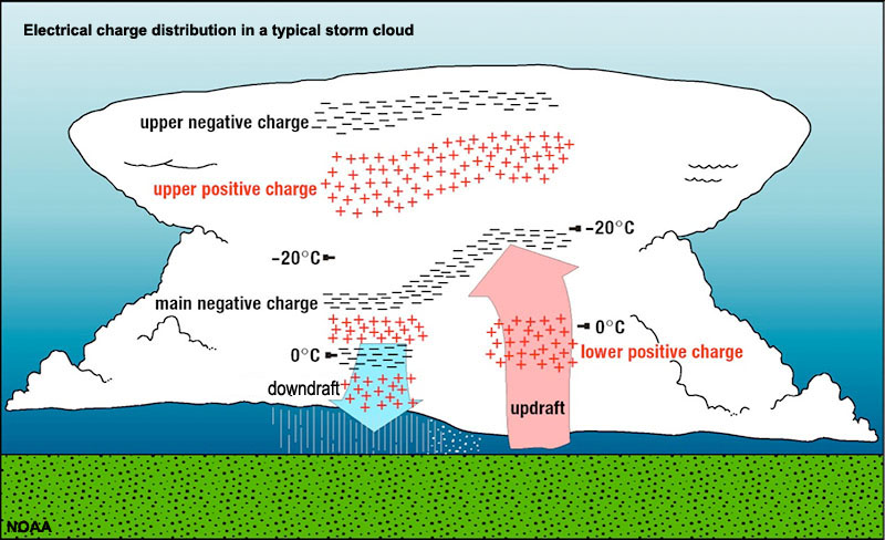
Figure 8.23. Lightning charges (positive and negative) can build up in different parts of a cloud relating to updrafts and down-drafts, and the changing character of precipitation within a cloud.
Lightning is associated with thunderstorms, but they are also known to occur in association with the clouds associated with volcanic eruptions, hurricanes, tornadoes, forest fires, snow storms, and even discharges from the ground during earthquakes.
The power or intensity of lightning varies with the volume of atmosphere hosting electrostatic charges and the distance lightning travels. A typical lightning stroke only lasts about 0.2 seconds. However, a typical lightning bolt can generate up to one billion volts, and they average between 5,000 to 20,000 amps of electrical current (as much as 200,000 amps have been measured - enough to briefly power a small city!). Lighting can heat the air to temperatures around 15,000 to 60,000 degrees Fahrenheit (or much higher). This causes the air to rapidly expand, creating shock waves we hear as thunder. Up close, thunder form a nearby lightning strike sounds as a sharp clap-like high frequency crackle and initial boom, followed by an extended low-frequency rumble as sound wave arrive at different times from farther distant parts of the lightning’s path (higher frequency sounds are absorbed as they travel over longer distances through the air). Thunder can be heard for distances of 25 miles or more under the right conditions.
Estimates vary, but as many as 10,000 fires are started each year by lightning, and lightning kills between 6,000 and 24,000 people and lightning injures as many as 240,000 people each year.
How far away was that lightning strike?
After you see a flash of lightning start counting seconds. For every 5 seconds the lightning bolt is one mile away. It is advised to take shelter immediately if the sound is less than 5 seconds!
Weather Fronts
A weather front is a boundary separating two masses of air of different densities (Figure 8.24). Fronts are classified as to which type of air mass (cold or warm) is replacing the other.
A cold front forms along the leading edge of a cold air mass displacing a warmer (less dense) air mass. Cold fronts are typically narrow bands of showers and thunderstorm and are most commonly associated with severe weather condition.
A warm front is the leading edge of a warmer air mass replacing (riding up and over) a colder air mass. If the front is essentially not moving (i.e. the air masses are not moving) it is called a stationary front. Warm fronts typically have a gentle slope so the air rising along the frontal surface is gradual. This configurations results in widespread stratus (strato-form) cloud layers with precipitation near the rear of the frontal boundary. Warm fronts typically quite extensive, and can create typically gray skies and dismal weather—an all too common occurrence in parts of the Midwest and Northeastern United States as slow-moving warm fronts stall over the regions. This can happen any time of year. It reflects that warm, moist air is flowing above cooler air down below, creating the gray stratus cloud layer in-between.
Colliding air masses can have both warm fronts. For instance, when a warm, moist air mass (such a maritime-tropical air mass) encounters a cold, dry air mass (such a polar continental air mass), both warm fronts and cold fronts can form as air rotates around a center of low pressure (as illustrated in the lower graphic of Figure 8.24). This rotation is driven by the Coriolis effect (discussed below).
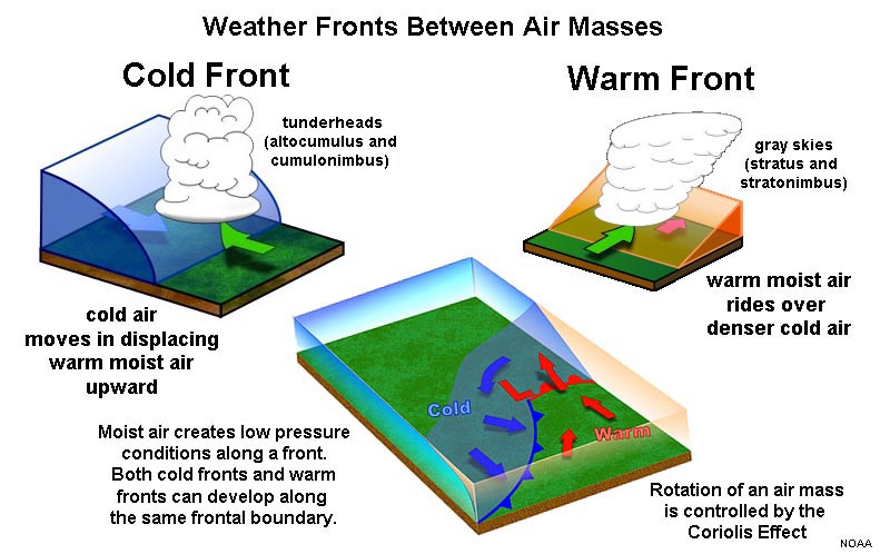
Figure 8.24. Weather fronts between air masses: cold fronts and warm fronts.
How do you say which way is the wind blowing?
We name wind direction based on which direction it is coming from (from high pressure to low pressure). For instance, if the wind is moving off the Pacific Ocean directly onto the land in California we call it a west wind, or to clarify, out of the west. The direction of wind is named for the direction it is coming from, not in the direction that it is moving towards.