
4.12: California Geology and Plate Tectonics History
- Page ID
- 9859

\( \newcommand{\vecs}[1]{\overset { \scriptstyle \rightharpoonup} {\mathbf{#1}} } \)
\( \newcommand{\vecd}[1]{\overset{-\!-\!\rightharpoonup}{\vphantom{a}\smash {#1}}} \)
\( \newcommand{\id}{\mathrm{id}}\) \( \newcommand{\Span}{\mathrm{span}}\)
( \newcommand{\kernel}{\mathrm{null}\,}\) \( \newcommand{\range}{\mathrm{range}\,}\)
\( \newcommand{\RealPart}{\mathrm{Re}}\) \( \newcommand{\ImaginaryPart}{\mathrm{Im}}\)
\( \newcommand{\Argument}{\mathrm{Arg}}\) \( \newcommand{\norm}[1]{\| #1 \|}\)
\( \newcommand{\inner}[2]{\langle #1, #2 \rangle}\)
\( \newcommand{\Span}{\mathrm{span}}\)
\( \newcommand{\id}{\mathrm{id}}\)
\( \newcommand{\Span}{\mathrm{span}}\)
\( \newcommand{\kernel}{\mathrm{null}\,}\)
\( \newcommand{\range}{\mathrm{range}\,}\)
\( \newcommand{\RealPart}{\mathrm{Re}}\)
\( \newcommand{\ImaginaryPart}{\mathrm{Im}}\)
\( \newcommand{\Argument}{\mathrm{Arg}}\)
\( \newcommand{\norm}[1]{\| #1 \|}\)
\( \newcommand{\inner}[2]{\langle #1, #2 \rangle}\)
\( \newcommand{\Span}{\mathrm{span}}\) \( \newcommand{\AA}{\unicode[.8,0]{x212B}}\)
\( \newcommand{\vectorA}[1]{\vec{#1}} % arrow\)
\( \newcommand{\vectorAt}[1]{\vec{\text{#1}}} % arrow\)
\( \newcommand{\vectorB}[1]{\overset { \scriptstyle \rightharpoonup} {\mathbf{#1}} } \)
\( \newcommand{\vectorC}[1]{\textbf{#1}} \)
\( \newcommand{\vectorD}[1]{\overrightarrow{#1}} \)
\( \newcommand{\vectorDt}[1]{\overrightarrow{\text{#1}}} \)
\( \newcommand{\vectE}[1]{\overset{-\!-\!\rightharpoonup}{\vphantom{a}\smash{\mathbf {#1}}}} \)
\( \newcommand{\vecs}[1]{\overset { \scriptstyle \rightharpoonup} {\mathbf{#1}} } \)
\( \newcommand{\vecd}[1]{\overset{-\!-\!\rightharpoonup}{\vphantom{a}\smash {#1}}} \)
\(\newcommand{\avec}{\mathbf a}\) \(\newcommand{\bvec}{\mathbf b}\) \(\newcommand{\cvec}{\mathbf c}\) \(\newcommand{\dvec}{\mathbf d}\) \(\newcommand{\dtil}{\widetilde{\mathbf d}}\) \(\newcommand{\evec}{\mathbf e}\) \(\newcommand{\fvec}{\mathbf f}\) \(\newcommand{\nvec}{\mathbf n}\) \(\newcommand{\pvec}{\mathbf p}\) \(\newcommand{\qvec}{\mathbf q}\) \(\newcommand{\svec}{\mathbf s}\) \(\newcommand{\tvec}{\mathbf t}\) \(\newcommand{\uvec}{\mathbf u}\) \(\newcommand{\vvec}{\mathbf v}\) \(\newcommand{\wvec}{\mathbf w}\) \(\newcommand{\xvec}{\mathbf x}\) \(\newcommand{\yvec}{\mathbf y}\) \(\newcommand{\zvec}{\mathbf z}\) \(\newcommand{\rvec}{\mathbf r}\) \(\newcommand{\mvec}{\mathbf m}\) \(\newcommand{\zerovec}{\mathbf 0}\) \(\newcommand{\onevec}{\mathbf 1}\) \(\newcommand{\real}{\mathbb R}\) \(\newcommand{\twovec}[2]{\left[\begin{array}{r}#1 \\ #2 \end{array}\right]}\) \(\newcommand{\ctwovec}[2]{\left[\begin{array}{c}#1 \\ #2 \end{array}\right]}\) \(\newcommand{\threevec}[3]{\left[\begin{array}{r}#1 \\ #2 \\ #3 \end{array}\right]}\) \(\newcommand{\cthreevec}[3]{\left[\begin{array}{c}#1 \\ #2 \\ #3 \end{array}\right]}\) \(\newcommand{\fourvec}[4]{\left[\begin{array}{r}#1 \\ #2 \\ #3 \\ #4 \end{array}\right]}\) \(\newcommand{\cfourvec}[4]{\left[\begin{array}{c}#1 \\ #2 \\ #3 \\ #4 \end{array}\right]}\) \(\newcommand{\fivevec}[5]{\left[\begin{array}{r}#1 \\ #2 \\ #3 \\ #4 \\ #5 \\ \end{array}\right]}\) \(\newcommand{\cfivevec}[5]{\left[\begin{array}{c}#1 \\ #2 \\ #3 \\ #4 \\ #5 \\ \end{array}\right]}\) \(\newcommand{\mattwo}[4]{\left[\begin{array}{rr}#1 \amp #2 \\ #3 \amp #4 \\ \end{array}\right]}\) \(\newcommand{\laspan}[1]{\text{Span}\{#1\}}\) \(\newcommand{\bcal}{\cal B}\) \(\newcommand{\ccal}{\cal C}\) \(\newcommand{\scal}{\cal S}\) \(\newcommand{\wcal}{\cal W}\) \(\newcommand{\ecal}{\cal E}\) \(\newcommand{\coords}[2]{\left\{#1\right\}_{#2}}\) \(\newcommand{\gray}[1]{\color{gray}{#1}}\) \(\newcommand{\lgray}[1]{\color{lightgray}{#1}}\) \(\newcommand{\rank}{\operatorname{rank}}\) \(\newcommand{\row}{\text{Row}}\) \(\newcommand{\col}{\text{Col}}\) \(\renewcommand{\row}{\text{Row}}\) \(\newcommand{\nul}{\text{Nul}}\) \(\newcommand{\var}{\text{Var}}\) \(\newcommand{\corr}{\text{corr}}\) \(\newcommand{\len}[1]{\left|#1\right|}\) \(\newcommand{\bbar}{\overline{\bvec}}\) \(\newcommand{\bhat}{\widehat{\bvec}}\) \(\newcommand{\bperp}{\bvec^\perp}\) \(\newcommand{\xhat}{\widehat{\xvec}}\) \(\newcommand{\vhat}{\widehat{\vvec}}\) \(\newcommand{\uhat}{\widehat{\uvec}}\) \(\newcommand{\what}{\widehat{\wvec}}\) \(\newcommand{\Sighat}{\widehat{\Sigma}}\) \(\newcommand{\lt}{<}\) \(\newcommand{\gt}{>}\) \(\newcommand{\amp}{&}\) \(\definecolor{fillinmathshade}{gray}{0.9}\)California Geology and Plate Tectonics History
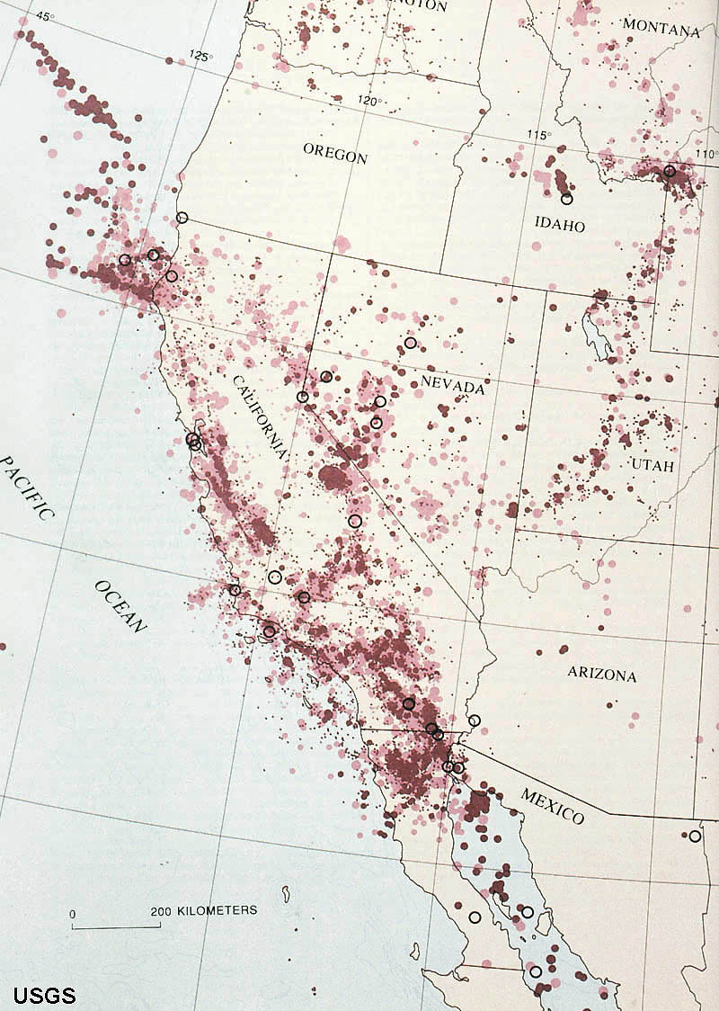
California has been one of most studied geologic region of the world, and for good reasons: earthquakes!
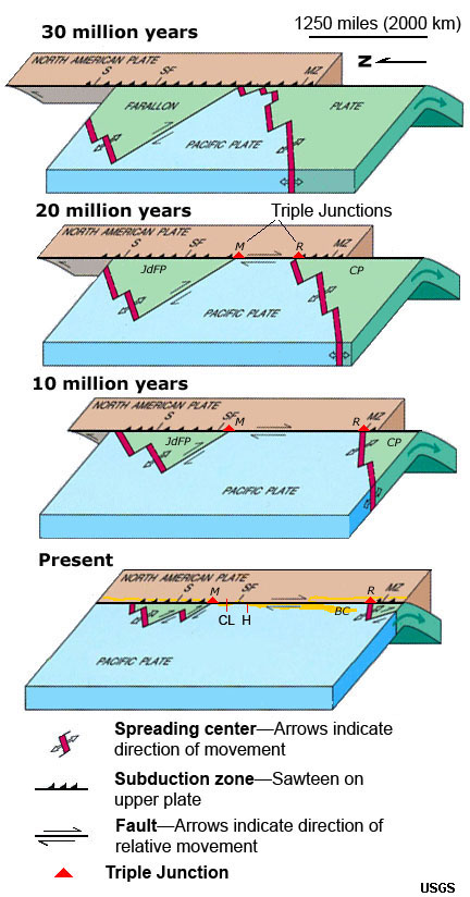
Through its history, California has transitioned from a passive continental margin (before the breakup of Pangaea) to an active margin with the transition to subduction zone activity and the formation of the Cordilleran volcanic chain (during the Mesozoic Era). The Cordilleran Ranges is name for the volcanic arc that formed the Sierra Nevada Range and the Peninsular Ranges extending south in to Baja California). Subduction ended when the ancient Farallon Plate was overrun as North America moved westward, overriding the northern end of the spreading center in the Eastern Pacific basin (Figure 7.62). This lead to the formation to the modern transform plate boundary associated with the San Andreas Fault (part of the greater California fault system) and the opening of the Gulf of California.
 |
 |
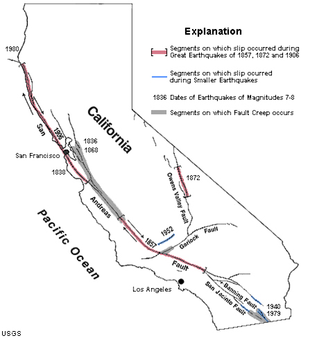 |
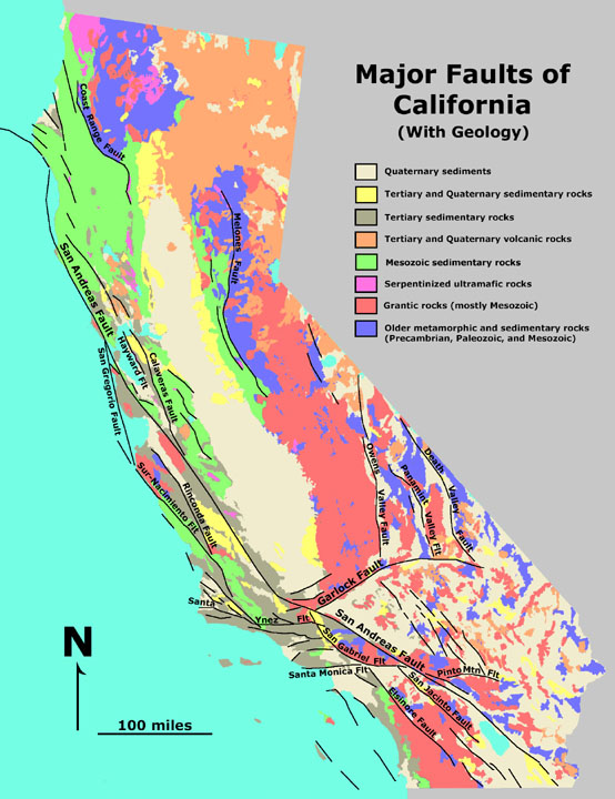
| Figure 4.36. Geologic map of California shows the complexity of the different regions within the state. | Figure 4.37. California earthquakes demonstrate that the region is an active margin | Figure 4.38. The San Andreas Fault System in California showing the locations impacted by major earthquakes. |
 |
Assembling California: California formed gradually over a billion years though processes involving subduction (forming island arcs) and by accretion (attachment of small land masses carried in for other parts of the Pacific Ocean basin). Before the opening of the Atlantic Ocean Basin, California was sometimes a passive margin. |
Information about the geologic evolution of California: Geologic History of Central California A technical report about the San Andreas Fault System: Wallace, Robert E., 1990, The San Andreas Fault System, California: U.S. Geological Survey, 283 p. This historically significant report provides an overview of the history, geology, geomorphology, geophysics, and seismology of the most well known plate-tectonic boundary in the world. |
Generalized California Plate Tectonic History:No rocks older than ~1 billion years exist in CA - all materials in the CA region were subducted or moved elsewhere...~1 billion to ~250 million: CA was a mostly a passive margin or was accumulating as sediments on an actively migrating seafloor. Periods of mountain building and other plate-tectonic-related activity moved small land masses along the West Coast region. North America moved westward and northward over time. ~250 to ~30 million: subduction and island-arc volcanism dominated the CA coast. An ocean trench existed along where the coast exists today, and a subduction-zone-related igneous activity created the great volcanic arc formed the core of the Sierra Nevada ~30 years ago to present: the San Andreas Fault System began to modify the coastline - transform faulting replaced subduction . Baja California split away from the Mexico. Uplift and erosion has exposed the core of the ancient volcanic arc, now exposed throughout the Sierra Nevada and Peninsula Range (Baja and San Diego region). |
||
| Figure 4.39. Formation of the San Andreas Fault caused by North America Plate overriding the ancient Farallon Plate. Remnants of the Farallon Plate exist as the Juan de Fuca Plate (offshore Oregon & Washington) and the Cocos Plate (off central America). |
Supporting evidence of long-distance movement along the San Andreas Fault System.
 |
 |
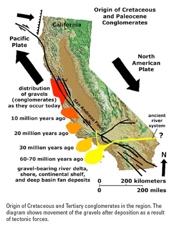 |
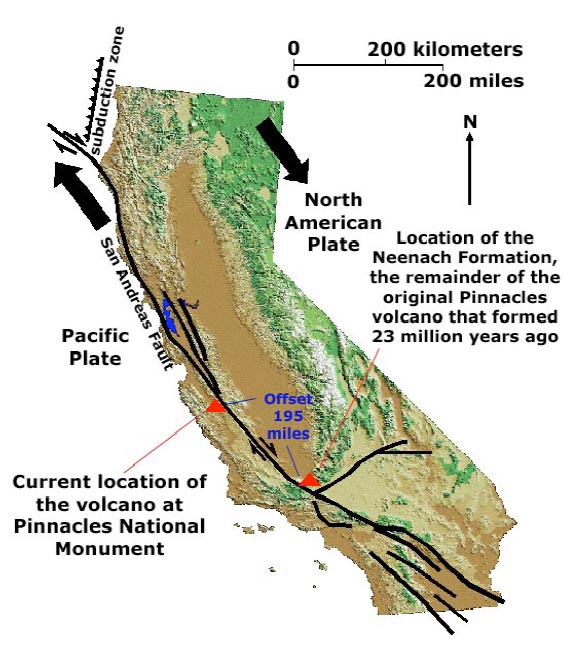
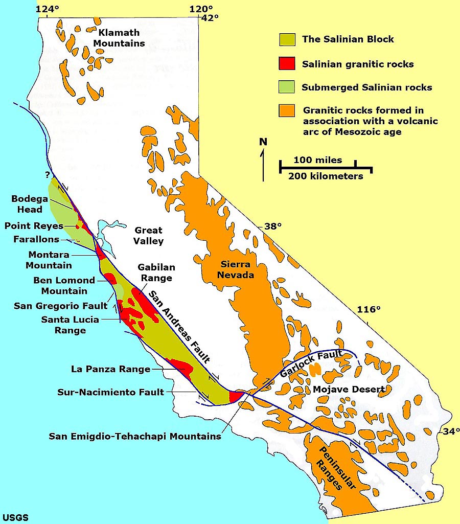
| Figure 4.40. The Pinnacles Volcano originally formed near Los Angeles nearly 23 million years ago. The western half (Pinnacles Formation) is now about 215 miles [350 km] north of the eastern half (Neenach Formation). | Figure 4.41. Granitic basement rocks in the Coast Ranges originally formed as part of an volcanic arc complex in the Mesozoic Era. They were ripped off of SoCal and carried northward by plate tectonics motion. | Figure 4.42. Cretaceous-age gravels deposited by an ancient river system in southern California were carried northward from their source area and are now scattered throughout the Coast Ranges. |