
2.2: Overview
- Page ID
- 14921

\( \newcommand{\vecs}[1]{\overset { \scriptstyle \rightharpoonup} {\mathbf{#1}} } \)
\( \newcommand{\vecd}[1]{\overset{-\!-\!\rightharpoonup}{\vphantom{a}\smash {#1}}} \)
\( \newcommand{\id}{\mathrm{id}}\) \( \newcommand{\Span}{\mathrm{span}}\)
( \newcommand{\kernel}{\mathrm{null}\,}\) \( \newcommand{\range}{\mathrm{range}\,}\)
\( \newcommand{\RealPart}{\mathrm{Re}}\) \( \newcommand{\ImaginaryPart}{\mathrm{Im}}\)
\( \newcommand{\Argument}{\mathrm{Arg}}\) \( \newcommand{\norm}[1]{\| #1 \|}\)
\( \newcommand{\inner}[2]{\langle #1, #2 \rangle}\)
\( \newcommand{\Span}{\mathrm{span}}\)
\( \newcommand{\id}{\mathrm{id}}\)
\( \newcommand{\Span}{\mathrm{span}}\)
\( \newcommand{\kernel}{\mathrm{null}\,}\)
\( \newcommand{\range}{\mathrm{range}\,}\)
\( \newcommand{\RealPart}{\mathrm{Re}}\)
\( \newcommand{\ImaginaryPart}{\mathrm{Im}}\)
\( \newcommand{\Argument}{\mathrm{Arg}}\)
\( \newcommand{\norm}[1]{\| #1 \|}\)
\( \newcommand{\inner}[2]{\langle #1, #2 \rangle}\)
\( \newcommand{\Span}{\mathrm{span}}\) \( \newcommand{\AA}{\unicode[.8,0]{x212B}}\)
\( \newcommand{\vectorA}[1]{\vec{#1}} % arrow\)
\( \newcommand{\vectorAt}[1]{\vec{\text{#1}}} % arrow\)
\( \newcommand{\vectorB}[1]{\overset { \scriptstyle \rightharpoonup} {\mathbf{#1}} } \)
\( \newcommand{\vectorC}[1]{\textbf{#1}} \)
\( \newcommand{\vectorD}[1]{\overrightarrow{#1}} \)
\( \newcommand{\vectorDt}[1]{\overrightarrow{\text{#1}}} \)
\( \newcommand{\vectE}[1]{\overset{-\!-\!\rightharpoonup}{\vphantom{a}\smash{\mathbf {#1}}}} \)
\( \newcommand{\vecs}[1]{\overset { \scriptstyle \rightharpoonup} {\mathbf{#1}} } \)
\( \newcommand{\vecd}[1]{\overset{-\!-\!\rightharpoonup}{\vphantom{a}\smash {#1}}} \)
\(\newcommand{\avec}{\mathbf a}\) \(\newcommand{\bvec}{\mathbf b}\) \(\newcommand{\cvec}{\mathbf c}\) \(\newcommand{\dvec}{\mathbf d}\) \(\newcommand{\dtil}{\widetilde{\mathbf d}}\) \(\newcommand{\evec}{\mathbf e}\) \(\newcommand{\fvec}{\mathbf f}\) \(\newcommand{\nvec}{\mathbf n}\) \(\newcommand{\pvec}{\mathbf p}\) \(\newcommand{\qvec}{\mathbf q}\) \(\newcommand{\svec}{\mathbf s}\) \(\newcommand{\tvec}{\mathbf t}\) \(\newcommand{\uvec}{\mathbf u}\) \(\newcommand{\vvec}{\mathbf v}\) \(\newcommand{\wvec}{\mathbf w}\) \(\newcommand{\xvec}{\mathbf x}\) \(\newcommand{\yvec}{\mathbf y}\) \(\newcommand{\zvec}{\mathbf z}\) \(\newcommand{\rvec}{\mathbf r}\) \(\newcommand{\mvec}{\mathbf m}\) \(\newcommand{\zerovec}{\mathbf 0}\) \(\newcommand{\onevec}{\mathbf 1}\) \(\newcommand{\real}{\mathbb R}\) \(\newcommand{\twovec}[2]{\left[\begin{array}{r}#1 \\ #2 \end{array}\right]}\) \(\newcommand{\ctwovec}[2]{\left[\begin{array}{c}#1 \\ #2 \end{array}\right]}\) \(\newcommand{\threevec}[3]{\left[\begin{array}{r}#1 \\ #2 \\ #3 \end{array}\right]}\) \(\newcommand{\cthreevec}[3]{\left[\begin{array}{c}#1 \\ #2 \\ #3 \end{array}\right]}\) \(\newcommand{\fourvec}[4]{\left[\begin{array}{r}#1 \\ #2 \\ #3 \\ #4 \end{array}\right]}\) \(\newcommand{\cfourvec}[4]{\left[\begin{array}{c}#1 \\ #2 \\ #3 \\ #4 \end{array}\right]}\) \(\newcommand{\fivevec}[5]{\left[\begin{array}{r}#1 \\ #2 \\ #3 \\ #4 \\ #5 \\ \end{array}\right]}\) \(\newcommand{\cfivevec}[5]{\left[\begin{array}{c}#1 \\ #2 \\ #3 \\ #4 \\ #5 \\ \end{array}\right]}\) \(\newcommand{\mattwo}[4]{\left[\begin{array}{rr}#1 \amp #2 \\ #3 \amp #4 \\ \end{array}\right]}\) \(\newcommand{\laspan}[1]{\text{Span}\{#1\}}\) \(\newcommand{\bcal}{\cal B}\) \(\newcommand{\ccal}{\cal C}\) \(\newcommand{\scal}{\cal S}\) \(\newcommand{\wcal}{\cal W}\) \(\newcommand{\ecal}{\cal E}\) \(\newcommand{\coords}[2]{\left\{#1\right\}_{#2}}\) \(\newcommand{\gray}[1]{\color{gray}{#1}}\) \(\newcommand{\lgray}[1]{\color{lightgray}{#1}}\) \(\newcommand{\rank}{\operatorname{rank}}\) \(\newcommand{\row}{\text{Row}}\) \(\newcommand{\col}{\text{Col}}\) \(\renewcommand{\row}{\text{Row}}\) \(\newcommand{\nul}{\text{Nul}}\) \(\newcommand{\var}{\text{Var}}\) \(\newcommand{\corr}{\text{corr}}\) \(\newcommand{\len}[1]{\left|#1\right|}\) \(\newcommand{\bbar}{\overline{\bvec}}\) \(\newcommand{\bhat}{\widehat{\bvec}}\) \(\newcommand{\bperp}{\bvec^\perp}\) \(\newcommand{\xhat}{\widehat{\xvec}}\) \(\newcommand{\vhat}{\widehat{\vvec}}\) \(\newcommand{\uhat}{\widehat{\uvec}}\) \(\newcommand{\what}{\widehat{\wvec}}\) \(\newcommand{\Sighat}{\widehat{\Sigma}}\) \(\newcommand{\lt}{<}\) \(\newcommand{\gt}{>}\) \(\newcommand{\amp}{&}\) \(\definecolor{fillinmathshade}{gray}{0.9}\)We need a basic understanding of plate tectonics in order to appreciate how the ocean basins have evolved over geologic time and how they will evolve in the future. I suspect that many, if not all of you, are experts on plate tectonics, and the M. Ed. program at Penn State has a course devoted to the Solid Earth (Earth 520), so we won’t cover things in an exhaustive/comprehensive fashion. Instead, we’ll pick a few representative activities that will highlight the connections we need for Oceanography and help you to see what additional background would be useful for you.
A brief background on Plate Tectonics and Continental Drift
The notion that plates move has been around since at least early 1900's. Alfred Wegener, a German Meteorologist, proposed the theory of Continental Drift. He used a variety of observations to argue that the continents had moved and broken apart –including the shapes of coast lines, palaeontological and botanical data, and geological data. But he lacked a credible theory for motion. Physicists of his day dismissed the notion that the continents could move because they thought Earth’s interior was solid and rigid. Nevertheless, various people worked on the theory and proposed modifications. One such was Alex Du Toit, a south American geologist who collected geologic observations from both sides of the south Atlantic and published them in the 1930’s. A number of discoveries in the 1950’s and early 1960’s, including age dating of rocks and magnetic signatures in rocks, led first to the theory of ‘sea floor spreading’ and then to the theory of plate tectonics. A naval captain, Harry Hess, proposed sea floor spreading on the basis of bathymetric profiles he made in the pacific. His data showed that ocean depth increased systematically and symmetrically from a long, axial ridge. Hess’ data were combined with other key observations (including magnetic stripes, heat flow, seismicity along plate boundaries) and ideas (mantle convection) to form the theory of plate tectonics.
Tenets of the theory:
- Plates are rigid
- Earth is a perfect sphere (and points on it can be specified with a radius vector)
- Plates move tangential to the radius vector.
- Material is created and destroyed at spreading ridges and subduction zones, but not at transform boundaries.
- Transform faults form small circles to poles of rotation.
Three important issues for plate tectonics
Issue #1: Earth’s Internal Structure
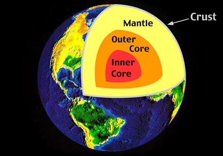
Sketch of Earth’s Internal Structure showing the main features.
Credit: Physical Geography
The Earth’s internal structure is made up of three layers called the crust, mantle, and core. The crust is the outermost layers made up of solid rocks mostly silicon and aluminum. The mantle is the layer beneath the crust and made up of mostly silicon and magnesium. The mantle has two layers called the upper mantle and the lower mantle, collectively called the lithosphere. The oceanic and continental plates are in the mantle. The core is the innermost layer of the Earth and is made of solid iron and nickel. The outer core is a liquid layer beneath the mantle and the inner core is the center of the Earth.
Check this out!
A few cool facts:
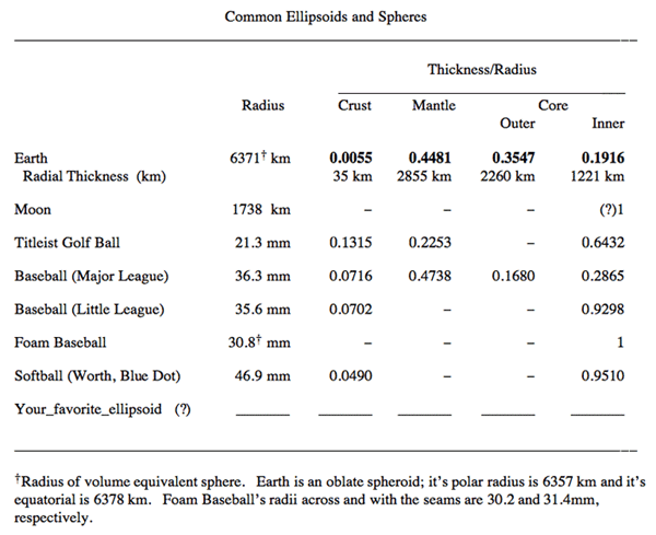
- The density contrast between the Lithosphere (roughly 2.5 to 3 gm/cc) and the Atmosphere above it (roughly 0) is not nearly as big as that between the Outer Core (roughly 11 gm/cc) and the base of the Mantle (roughly 6 gm/cc).
- Good place to learn more about Earth Structure.(link is external)
- Better place to learn more about Earth Structure.
- Look at how thin the Crust is! Challenge: Find a better Earth analog than a Major League Baseball (see Activity 1)
Issue #2: Plate Boundaries
There are three types of plate boundaries:
- Divergent,
- Convergent, and
- Transform.
In the parlance of structural geology: Divergent Boundaries correspond to normal faults, Convergent Boundaries correspond to thrust (or reverse) faults, and Transform Boundaries correspond to strike slip faults .
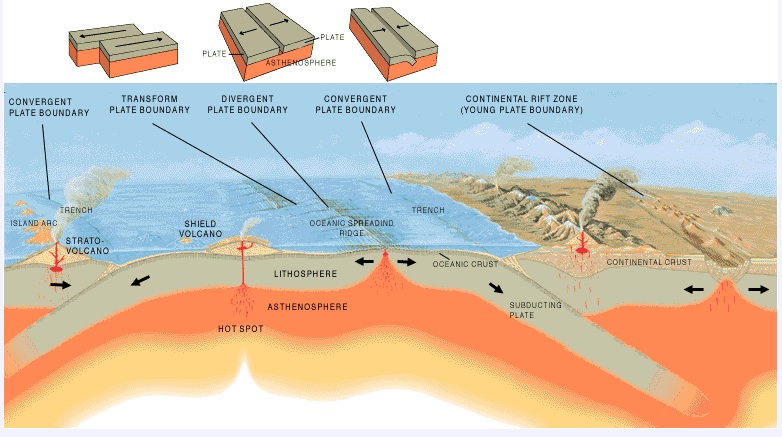
Artist's cross section illustrating the main types of plate boundaries.
Credit: Cross section by José F. Vigil from This Dynamic Planet—a wall map produced jointly by the U.S. Geological Survey(link is external), the Smithsonian Institution, and the U.S. Naval Research Laboratory.
Want to learn more?
If you’d like more background on Faulting, see the page on "Faults" from Prof. Eliza Richardson’s course, EARTH 520: Plate Tectonics and People.
Issue #3: Earth is an oblate sphere, which means it is elliptical!
Okay! The main thing is that it's roughly spherical (NOT flat!). The average radius of Earth is 6,371 km and the radius is nearly 22 km larger at the equator than at the poles (it's an ellipsoid, rather than a perfect sphere!). The lithospheric plates move on the outer surface of a sphere, so it's convenient to describe plate motion in terms of a rotation about a point on Earth's surface (or a rotation vector that hypothetically extends from Earth's center to the surface point). This point is called the pole of rotation, or just the rotation pole.
Let's start with a useful formula for the radius:
Earth is not a perfect sphere: its ellipticity can be written: f=(Re−Rp)Ref=Re−RpRe
where Re is the equatorial radius=6378.14 km, and Rp is polar radius=6356.75 km. To first order, the variation in radius with latitude, λ, can be written: R(λ)=Re(1−f sin2λ)R(λ)=Re(1−f sin2λ)
Want to learn more?
Read about changes in Earth’s shape due to climate events in the following NASA article: "Some changes in Earth's Shape Are Due to Changes in Climate(link is external)."
Map view symbols for plate boundaries
.jpg?revision=1)
Want to learn more?
Want more background or do you need more help with plate boundaries and plate names? Take a look at This PBS Learning Site(link is external)
Try this!
Can you identify the type of faulting occurring at each plate boundary in the map below? What type of faulting is depicted between the Nazca and South American plates?
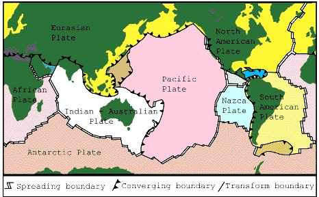
Based on a map prepared by the U.S. Geological Survey.
Credit: (link is external)University of Wisconsin