
13.3: C.3- Explanatory notes
- Page ID
- 16477

\( \newcommand{\vecs}[1]{\overset { \scriptstyle \rightharpoonup} {\mathbf{#1}} } \)
\( \newcommand{\vecd}[1]{\overset{-\!-\!\rightharpoonup}{\vphantom{a}\smash {#1}}} \)
\( \newcommand{\id}{\mathrm{id}}\) \( \newcommand{\Span}{\mathrm{span}}\)
( \newcommand{\kernel}{\mathrm{null}\,}\) \( \newcommand{\range}{\mathrm{range}\,}\)
\( \newcommand{\RealPart}{\mathrm{Re}}\) \( \newcommand{\ImaginaryPart}{\mathrm{Im}}\)
\( \newcommand{\Argument}{\mathrm{Arg}}\) \( \newcommand{\norm}[1]{\| #1 \|}\)
\( \newcommand{\inner}[2]{\langle #1, #2 \rangle}\)
\( \newcommand{\Span}{\mathrm{span}}\)
\( \newcommand{\id}{\mathrm{id}}\)
\( \newcommand{\Span}{\mathrm{span}}\)
\( \newcommand{\kernel}{\mathrm{null}\,}\)
\( \newcommand{\range}{\mathrm{range}\,}\)
\( \newcommand{\RealPart}{\mathrm{Re}}\)
\( \newcommand{\ImaginaryPart}{\mathrm{Im}}\)
\( \newcommand{\Argument}{\mathrm{Arg}}\)
\( \newcommand{\norm}[1]{\| #1 \|}\)
\( \newcommand{\inner}[2]{\langle #1, #2 \rangle}\)
\( \newcommand{\Span}{\mathrm{span}}\) \( \newcommand{\AA}{\unicode[.8,0]{x212B}}\)
\( \newcommand{\vectorA}[1]{\vec{#1}} % arrow\)
\( \newcommand{\vectorAt}[1]{\vec{\text{#1}}} % arrow\)
\( \newcommand{\vectorB}[1]{\overset { \scriptstyle \rightharpoonup} {\mathbf{#1}} } \)
\( \newcommand{\vectorC}[1]{\textbf{#1}} \)
\( \newcommand{\vectorD}[1]{\overrightarrow{#1}} \)
\( \newcommand{\vectorDt}[1]{\overrightarrow{\text{#1}}} \)
\( \newcommand{\vectE}[1]{\overset{-\!-\!\rightharpoonup}{\vphantom{a}\smash{\mathbf {#1}}}} \)
\( \newcommand{\vecs}[1]{\overset { \scriptstyle \rightharpoonup} {\mathbf{#1}} } \)
\( \newcommand{\vecd}[1]{\overset{-\!-\!\rightharpoonup}{\vphantom{a}\smash {#1}}} \)
\(\newcommand{\avec}{\mathbf a}\) \(\newcommand{\bvec}{\mathbf b}\) \(\newcommand{\cvec}{\mathbf c}\) \(\newcommand{\dvec}{\mathbf d}\) \(\newcommand{\dtil}{\widetilde{\mathbf d}}\) \(\newcommand{\evec}{\mathbf e}\) \(\newcommand{\fvec}{\mathbf f}\) \(\newcommand{\nvec}{\mathbf n}\) \(\newcommand{\pvec}{\mathbf p}\) \(\newcommand{\qvec}{\mathbf q}\) \(\newcommand{\svec}{\mathbf s}\) \(\newcommand{\tvec}{\mathbf t}\) \(\newcommand{\uvec}{\mathbf u}\) \(\newcommand{\vvec}{\mathbf v}\) \(\newcommand{\wvec}{\mathbf w}\) \(\newcommand{\xvec}{\mathbf x}\) \(\newcommand{\yvec}{\mathbf y}\) \(\newcommand{\zvec}{\mathbf z}\) \(\newcommand{\rvec}{\mathbf r}\) \(\newcommand{\mvec}{\mathbf m}\) \(\newcommand{\zerovec}{\mathbf 0}\) \(\newcommand{\onevec}{\mathbf 1}\) \(\newcommand{\real}{\mathbb R}\) \(\newcommand{\twovec}[2]{\left[\begin{array}{r}#1 \\ #2 \end{array}\right]}\) \(\newcommand{\ctwovec}[2]{\left[\begin{array}{c}#1 \\ #2 \end{array}\right]}\) \(\newcommand{\threevec}[3]{\left[\begin{array}{r}#1 \\ #2 \\ #3 \end{array}\right]}\) \(\newcommand{\cthreevec}[3]{\left[\begin{array}{c}#1 \\ #2 \\ #3 \end{array}\right]}\) \(\newcommand{\fourvec}[4]{\left[\begin{array}{r}#1 \\ #2 \\ #3 \\ #4 \end{array}\right]}\) \(\newcommand{\cfourvec}[4]{\left[\begin{array}{c}#1 \\ #2 \\ #3 \\ #4 \end{array}\right]}\) \(\newcommand{\fivevec}[5]{\left[\begin{array}{r}#1 \\ #2 \\ #3 \\ #4 \\ #5 \\ \end{array}\right]}\) \(\newcommand{\cfivevec}[5]{\left[\begin{array}{c}#1 \\ #2 \\ #3 \\ #4 \\ #5 \\ \end{array}\right]}\) \(\newcommand{\mattwo}[4]{\left[\begin{array}{rr}#1 \amp #2 \\ #3 \amp #4 \\ \end{array}\right]}\) \(\newcommand{\laspan}[1]{\text{Span}\{#1\}}\) \(\newcommand{\bcal}{\cal B}\) \(\newcommand{\ccal}{\cal C}\) \(\newcommand{\scal}{\cal S}\) \(\newcommand{\wcal}{\cal W}\) \(\newcommand{\ecal}{\cal E}\) \(\newcommand{\coords}[2]{\left\{#1\right\}_{#2}}\) \(\newcommand{\gray}[1]{\color{gray}{#1}}\) \(\newcommand{\lgray}[1]{\color{lightgray}{#1}}\) \(\newcommand{\rank}{\operatorname{rank}}\) \(\newcommand{\row}{\text{Row}}\) \(\newcommand{\col}{\text{Col}}\) \(\renewcommand{\row}{\text{Row}}\) \(\newcommand{\nul}{\text{Nul}}\) \(\newcommand{\var}{\text{Var}}\) \(\newcommand{\corr}{\text{corr}}\) \(\newcommand{\len}[1]{\left|#1\right|}\) \(\newcommand{\bbar}{\overline{\bvec}}\) \(\newcommand{\bhat}{\widehat{\bvec}}\) \(\newcommand{\bperp}{\bvec^\perp}\) \(\newcommand{\xhat}{\widehat{\xvec}}\) \(\newcommand{\vhat}{\widehat{\vvec}}\) \(\newcommand{\uhat}{\widehat{\uvec}}\) \(\newcommand{\what}{\widehat{\wvec}}\) \(\newcommand{\Sighat}{\widehat{\Sigma}}\) \(\newcommand{\lt}{<}\) \(\newcommand{\gt}{>}\) \(\newcommand{\amp}{&}\) \(\definecolor{fillinmathshade}{gray}{0.9}\)The first thing to do when looking at a map is to study the key. The following information may be found:
Horizontal scale The scale indicating the dimensions of details at the map. Most sailors look at the latitude border scales at the side of the map. 1 Minute equals 1 nautical mile. Most coastal engineers look at the linear scale. As a result of the projection of the globe on a plane, the scale changes over the map. The larger the area covered by the chart, the larger the deviations.
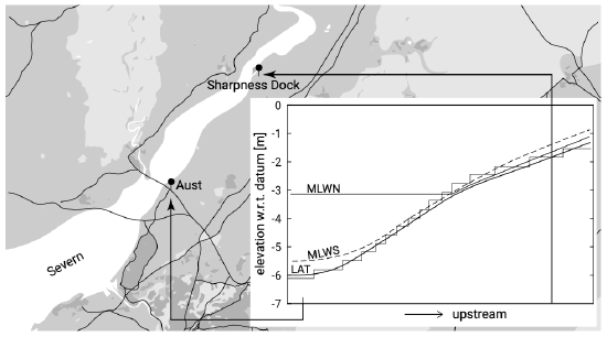
Figure C.1: River Severn (England).
Figure C.2: Chart Datum is not horizontal!
Vertical Scale Depth on a hydrographic chart may be shown in metres, feet or in fathoms. The reference level (Chart Datum) of the depths is also important. Chart Datum (CD) is often related to some specified tidal data. This may be LAT or MSL or any other reference level. Different countries use different definitions of CD! A Belgian map of the Western Scheldt may thus give different depth values than a Dutch map of the same area. Even on one map, the CD may differ for different locations because the tidal data differ from place to place. This poses a risk for the coastal engineer since we usually assume that the datum level of a map is horizontal. Specifically when we make hydraulic calculations, we must make sure that we use levels that find a reference to a horizontal plane to eliminate errors in the gravitational forces. A striking example is given in Fig. C.1. The result of misinterpretation is given in Fig. C.2.
- What happens to levels above the reference level like mud flats or sandbanks? These levels are underlined and refer to CD. Levels at the shore may also be shown. For these levels usually different reference levels are used rather than CD;
- Tidal streams/currents are sometimes shown;
- Dates of publication and dates of smaller or larger corrections;
- Tidal levels are usually shown at some specific locations as shown in Table C.1.
Terms related to tidal levels are summarised in Table C.2.
Table C.1: Tabular statement of semi-diurnal or diurnal tides.
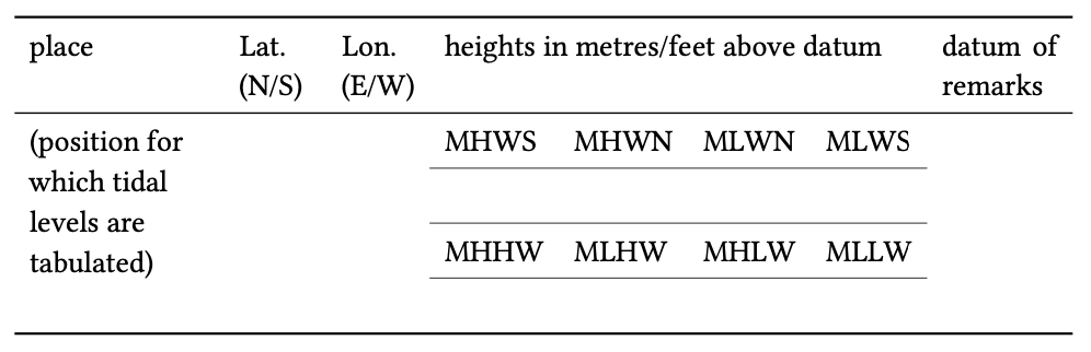
Table C.2: Terms related to tidal levels.
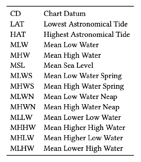
MSL – Mean Sea Level the average height of the sea measured over a long period of time. This is the average level which would exist in the absence of tides.
LAT – Lowest Astronomical Tide defined as the lowest tide level which can be predicted to occur under average meteorological conditions and under any combination of astronomical conditions.
HAT–Highest Astronomical Tide defined as the highest tide level which can be predicted to occur under average meteorological conditions and under any combination of astronomical conditions.
MHW – Mean High Water the average height of all high tides
MHHW–Mean Higher High water the average height of the higher of the two daily high tides over a long period of time. When only one high water occurs on a day, this is taken as the higher high water.
MLW – Mean Low Water the average height of all low tides
MLLW – Mean Lower Low Water the average height of the lower of the two daily low waters over a long period of time. When only one low water occurs on a day, this is taken as the lower low water.
MHWS – Mean High Water Spring the long term average of all high water observations of the heights of two successive high waters during those periods of 24 hours (approximately once a fortnight) when the range of tide is greatest, at full and new moon.
MLWS – Mean Low Water Spring the long term average of all low water observations of the heights of two successive low waters during those periods of 24 hours (approximately once a fortnight) when the range of tide is greatest, at full and new moon.
MHWN – Mean High Water Neap the long term average of all high water observations of the heights of two successive high waters when the range of tide is the least, at the time of first and last quarter of the moon.
MLWN – Mean Low Water Neap the long term average of all low water observations of the heights of two successive low waters when the range of tide is the least, at the time of first and last quarter of the moon.
MLHW – Mean Lower High Water the mean of the lower of the two daily high waters over a long period of time. When only one high water occurs on most days, no value is printed in the MLHW column, indicating that the tide is usually diurnal.
MHLW – Mean Higher Low Water the mean of the higher of the two daily low waters over a long period of time. When only one low water occurs on most days, no value is printed in the MHLW column, indicating that the tide is usually di- urnal.