17.4: Glaciations over Earth’s History
( \newcommand{\kernel}{\mathrm{null}\,}\)
We are currently living in the middle of a glacial period, though it’s less intense now than it was 20,000 years ago. This is not the only period of glaciation in Earth’s history; there have been many in the distant past (Figure 17.34). In general, however, over the course of Earth’s history the Earth’s surface has been warm and ice-free for longer periods than it has been cold and glaciated.

Pre-Cenozoic Glaciations
The oldest known glacial period is the Huronian. Based on evidence of glacial deposits from the area around Lake Huron in Ontario and elsewhere, it’s evident that the Huronian Glaciation lasted from approximately 2.4 to 2.1 Ga. Because rocks of that age are rare, we don’t know much about the intensity or global extent of this glaciation. Late in the Proterozoic, Earth had the most intense time of glaciation it has ever experienced. The glaciations of the Cryogenian Period (cryo is Latin for icy cold) are also known as the “Snowball Earth” glaciations. Scientists have hypothesized that the entire planet was frozen at this time—even in equatorial regions—with ice on the oceans up to 1 km thick. A factor in the cause of these glaciations may have been the development of and increased activity by photosynthetic organisms drawing down atmospheric carbon dioxide.
There were two main glacial periods within the Cryogenian, each lasting for about 20 million years: the Sturtian at around 700 Ma, and the Marinoan at 650 Ma. There is also evidence of some shorter glaciations both before and after these longer intervals. The end of the Cryogenian glaciations coincides with the evolution of relatively large and complex life forms on Earth. This started during the Ediacaran Period, and then continued with a diversification of life so sudden and dramatic that it’s called the Cambrian Explosion. The changing environmental conditions of the Cryogenian may have been what triggered the evolution of large and complex life.
There have been three major glaciations during the Phanerozoic (the past 541 Ma). These include the Andean/Saharan (recorded in rocks of South America and Africa), the Karoo (named for rocks in southern Africa), and the Cenozoic glaciations. The Karoo was the longest of the Phanerozoic glaciations, persisting for much of the time that the supercontinent Gondwana was situated over the South Pole (~360 to 260 Ma). Glaciers covered large parts of Africa, South America, Australia, and Antarctica. This widespread glaciation—across continents that are now far apart to explain the distribution of ice—was an important component of Alfred Wegener’s evidence for continental drift. Unlike the Cryogenian glaciations, the Andean/Saharan, Karoo, and Cenozoic glaciations only affected parts of Earth. During Karoo times, for example, what is now North America was near the equator and remained unglaciated.
Earth was warm and essentially unglaciated throughout the Mesozoic. Although there may have been some alpine glaciers at this time, they’ve left no evidence in the geologic record. The dinosaurs, which dominated terrestrial habitats during the Mesozoic, did not have to endure icy conditions.
Cenozoic Glaciations
A warm climate persisted into much of the Cenozoic. In fact, the Paleocene (from about 50 to 60 Ma) may have been the warmest part of the Phanerozoic since the Cambrian (Figure 17.35).

A number of tectonic events during the Cenozoic have contributed to persistent and significant planetary cooling from 50 Ma to near the present.
Formation of the Tibeta Plateau
The collision of the Indian plate with the Eurasian plate formed the Himalayan mountain range and the Tibetan Plateau. Mountain building events such as this are followed by weathering and erosion of the uplifted rocks. Higher than normal global rates of silicate mineral weathering associated with mountain building, especially weathering of feldspar, leads to a decrease in carbon dioxide concentrations in the atmosphere. This contributes to global climate cooling.

Opening the Drake Passage
At 40 Ma, ongoing plate motion widened the narrow gap between South America and Antarctica, resulting in the opening of the Drake Passage. This allowed for unrestricted west-to-east flow of water around Antarctica, called the Antarctic Circumpolar Current (Figure 17.36), which effectively isolated the Southern Ocean from the warmer waters of the Pacific, Atlantic, and Indian Oceans. The region cooled significantly, and by 35 Ma (Oligocene) glaciers had started to form on Antarctica.
Connecting North and South America
Global temperatures remained relatively steady during the Oligocene and early Miocene, and the Antarctic glaciation waned during that time. At around 15 Ma, subduction-related volcanism between central and South America created the land connection between North and South America, preventing water from flowing between the Pacific and Atlantic Oceans. This further restricted ocean currents that transfer heat from the tropics to the poles, leading to cooling and advance of the Antarctic glaciation.
Ice Feedbacks and the Pleistocene Glaciation
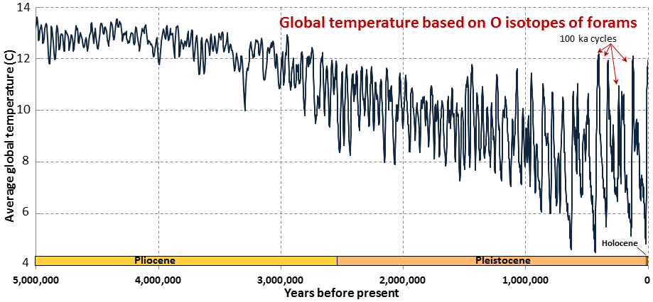
The expansion of the Antarctic ice sheet increased reflection of solar radiation at the Earth’s surface and promoted a positive feedback loop of further cooling: with more glacial ice reflecting sunlight, there was more cooling, leading to accumulation of more ice, and so on. By the Pliocene (~5 Ma) ice sheets had started to grow in North America and northern Europe. The most intense part of the current glaciation—and the coldest climate conditions of the current glaciation—has been during the past million years (the last third of the Pleistocene).
The Pleistocene Epoch of the Cenezoic Era (2.58 Ma to 0.126 Ma), is also known as the Ice Age, Pleistocene Glaciation, or Quaternary Glaciation. The Pleistocene has been characterized by temperature fluctuations over a range of almost 10°C on time scales of 40,000 to 100,000 years (Figure 17.37).

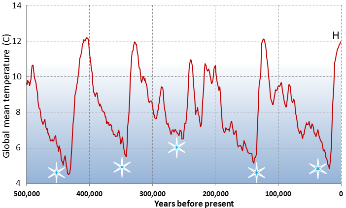
These temperature variations have corresponding with expansion and contraction of ice sheets. The temperature variations are attributed to subtle changes in Earth’s orbit, tilt, and wobble. These cyclical changes are called Milankovitch cycles. Over the past million years, the glaciation cycles have cycled over every 100,000 years, approximately. See if you can spot this trend in data from the last 500,000 years (Figure 17.38).

The Wisconsinian Glaciation
The Wisconsinan Glaciation was the last major continental glaciation in North America (from 150-50 ka). During the Wisconsinan, all of Canada and a small portion of the northern United States was covered with continental glaciers (Figure 17.39). The massive Laurentide Ice Sheet covered most of eastern Canada, as far west as the Rockies, and the smaller Cordilleran Ice Sheet covered most of the western region of present day BC and the Yukon Territory. At various other glacial peaks during the Pleistocene and Pliocene, the ice extent was similarly distributed over North America, and in some cases, was even more extensive. The combined Laurentide and Cordilleran Ice Sheets were comparable in volume to the current Antarctic Ice Sheet.

Why Does Earth Have Ice Ages?
Query 17.4.1
H5P content. You may want to remove or replace this element.
References
Hansen, J. E., and Sato, M. (2012). Climate Sensitivity Estimated From Earth’s Climate History. Read the paper
Lisiecki, L. E., and M. E. Raymo (2005). A Pliocene-Pleistocene stack of 57 globally distributed benthic d18O records. Paleoceanography, 20, PA1003. doi:10.1029/2004PA001071. View PDF
Zachos, J. C., Dickens, G. R., and Zeebe, R. E. (2008). An early Cenozoic perspective on greenhouse warming and carbon-cycle dynamics. Nature 541, 279-283. doi:10.1038/nature06588


