16.8: Activity 16G- Geologic Map of Yosemite Valley
- Page ID
- 14863
\( \newcommand{\vecs}[1]{\overset { \scriptstyle \rightharpoonup} {\mathbf{#1}} } \)
\( \newcommand{\vecd}[1]{\overset{-\!-\!\rightharpoonup}{\vphantom{a}\smash {#1}}} \)
\( \newcommand{\id}{\mathrm{id}}\) \( \newcommand{\Span}{\mathrm{span}}\)
( \newcommand{\kernel}{\mathrm{null}\,}\) \( \newcommand{\range}{\mathrm{range}\,}\)
\( \newcommand{\RealPart}{\mathrm{Re}}\) \( \newcommand{\ImaginaryPart}{\mathrm{Im}}\)
\( \newcommand{\Argument}{\mathrm{Arg}}\) \( \newcommand{\norm}[1]{\| #1 \|}\)
\( \newcommand{\inner}[2]{\langle #1, #2 \rangle}\)
\( \newcommand{\Span}{\mathrm{span}}\)
\( \newcommand{\id}{\mathrm{id}}\)
\( \newcommand{\Span}{\mathrm{span}}\)
\( \newcommand{\kernel}{\mathrm{null}\,}\)
\( \newcommand{\range}{\mathrm{range}\,}\)
\( \newcommand{\RealPart}{\mathrm{Re}}\)
\( \newcommand{\ImaginaryPart}{\mathrm{Im}}\)
\( \newcommand{\Argument}{\mathrm{Arg}}\)
\( \newcommand{\norm}[1]{\| #1 \|}\)
\( \newcommand{\inner}[2]{\langle #1, #2 \rangle}\)
\( \newcommand{\Span}{\mathrm{span}}\) \( \newcommand{\AA}{\unicode[.8,0]{x212B}}\)
\( \newcommand{\vectorA}[1]{\vec{#1}} % arrow\)
\( \newcommand{\vectorAt}[1]{\vec{\text{#1}}} % arrow\)
\( \newcommand{\vectorB}[1]{\overset { \scriptstyle \rightharpoonup} {\mathbf{#1}} } \)
\( \newcommand{\vectorC}[1]{\textbf{#1}} \)
\( \newcommand{\vectorD}[1]{\overrightarrow{#1}} \)
\( \newcommand{\vectorDt}[1]{\overrightarrow{\text{#1}}} \)
\( \newcommand{\vectE}[1]{\overset{-\!-\!\rightharpoonup}{\vphantom{a}\smash{\mathbf {#1}}}} \)
\( \newcommand{\vecs}[1]{\overset { \scriptstyle \rightharpoonup} {\mathbf{#1}} } \)
\( \newcommand{\vecd}[1]{\overset{-\!-\!\rightharpoonup}{\vphantom{a}\smash {#1}}} \)
\(\newcommand{\avec}{\mathbf a}\) \(\newcommand{\bvec}{\mathbf b}\) \(\newcommand{\cvec}{\mathbf c}\) \(\newcommand{\dvec}{\mathbf d}\) \(\newcommand{\dtil}{\widetilde{\mathbf d}}\) \(\newcommand{\evec}{\mathbf e}\) \(\newcommand{\fvec}{\mathbf f}\) \(\newcommand{\nvec}{\mathbf n}\) \(\newcommand{\pvec}{\mathbf p}\) \(\newcommand{\qvec}{\mathbf q}\) \(\newcommand{\svec}{\mathbf s}\) \(\newcommand{\tvec}{\mathbf t}\) \(\newcommand{\uvec}{\mathbf u}\) \(\newcommand{\vvec}{\mathbf v}\) \(\newcommand{\wvec}{\mathbf w}\) \(\newcommand{\xvec}{\mathbf x}\) \(\newcommand{\yvec}{\mathbf y}\) \(\newcommand{\zvec}{\mathbf z}\) \(\newcommand{\rvec}{\mathbf r}\) \(\newcommand{\mvec}{\mathbf m}\) \(\newcommand{\zerovec}{\mathbf 0}\) \(\newcommand{\onevec}{\mathbf 1}\) \(\newcommand{\real}{\mathbb R}\) \(\newcommand{\twovec}[2]{\left[\begin{array}{r}#1 \\ #2 \end{array}\right]}\) \(\newcommand{\ctwovec}[2]{\left[\begin{array}{c}#1 \\ #2 \end{array}\right]}\) \(\newcommand{\threevec}[3]{\left[\begin{array}{r}#1 \\ #2 \\ #3 \end{array}\right]}\) \(\newcommand{\cthreevec}[3]{\left[\begin{array}{c}#1 \\ #2 \\ #3 \end{array}\right]}\) \(\newcommand{\fourvec}[4]{\left[\begin{array}{r}#1 \\ #2 \\ #3 \\ #4 \end{array}\right]}\) \(\newcommand{\cfourvec}[4]{\left[\begin{array}{c}#1 \\ #2 \\ #3 \\ #4 \end{array}\right]}\) \(\newcommand{\fivevec}[5]{\left[\begin{array}{r}#1 \\ #2 \\ #3 \\ #4 \\ #5 \\ \end{array}\right]}\) \(\newcommand{\cfivevec}[5]{\left[\begin{array}{c}#1 \\ #2 \\ #3 \\ #4 \\ #5 \\ \end{array}\right]}\) \(\newcommand{\mattwo}[4]{\left[\begin{array}{rr}#1 \amp #2 \\ #3 \amp #4 \\ \end{array}\right]}\) \(\newcommand{\laspan}[1]{\text{Span}\{#1\}}\) \(\newcommand{\bcal}{\cal B}\) \(\newcommand{\ccal}{\cal C}\) \(\newcommand{\scal}{\cal S}\) \(\newcommand{\wcal}{\cal W}\) \(\newcommand{\ecal}{\cal E}\) \(\newcommand{\coords}[2]{\left\{#1\right\}_{#2}}\) \(\newcommand{\gray}[1]{\color{gray}{#1}}\) \(\newcommand{\lgray}[1]{\color{lightgray}{#1}}\) \(\newcommand{\rank}{\operatorname{rank}}\) \(\newcommand{\row}{\text{Row}}\) \(\newcommand{\col}{\text{Col}}\) \(\renewcommand{\row}{\text{Row}}\) \(\newcommand{\nul}{\text{Nul}}\) \(\newcommand{\var}{\text{Var}}\) \(\newcommand{\corr}{\text{corr}}\) \(\newcommand{\len}[1]{\left|#1\right|}\) \(\newcommand{\bbar}{\overline{\bvec}}\) \(\newcommand{\bhat}{\widehat{\bvec}}\) \(\newcommand{\bperp}{\bvec^\perp}\) \(\newcommand{\xhat}{\widehat{\xvec}}\) \(\newcommand{\vhat}{\widehat{\vvec}}\) \(\newcommand{\uhat}{\widehat{\uvec}}\) \(\newcommand{\what}{\widehat{\wvec}}\) \(\newcommand{\Sighat}{\widehat{\Sigma}}\) \(\newcommand{\lt}{<}\) \(\newcommand{\gt}{>}\) \(\newcommand{\amp}{&}\) \(\definecolor{fillinmathshade}{gray}{0.9}\)Visit the National Geologic Map Database and download the PDF version of Bedrock Geologic Map to Yosemite Valley (1985) by Frank Calkins (or ask your instructor if paper copies are available). Calkins did most of this mapping in the 1920s and his work was posthumously published by the USGS. Behold! This is one of the most famous maps in igneous petrology (the study of the chemistry and evolution of igneous rock and magma). We will use it to practice geologic and topographic map reading.
Part 1 - The Basics: This series of questions are designed to understand the basic geology and topography of the map.
- What is the map scale?
- What is the map’s contour interval?
- What is the map’s INDEX contour interval?
- What is the highest-elevation feature on the map? Hint: It is a peak near the east side of the map.
- What is its elevation?
- Where is the lowest-elevation feature on the map? Hint: Yosemite Valley is a…wait for it…VALLEY! And…what feature is typically positioned in the bottom of VALLEYS? Where are these features at their lowest elevation?
- What is its elevation at its lowest point?
- Which is higher elevation, El Capitan or Half Dome?
- What are the coordinates of the map’s northeast corner?
- Latitude:
- Longitude:
- What are the coordinates of the summit of El Capitan?
- Latitude:
- Longitude:
- What is the YOUNGEST rock?
- What is the Geologic Age?
- Where is it found?
- What is the OLDEST rock?
- What is the Geologic Age?
- Where is it found?
- What family of rocks is almost the entire map area made of?
- What Earth material covers almost the entire floor of Yosemite Valley?
Part 2 - Igneous Geology: Let’s review some concepts related to igneous processes. They do not involve the map. For a good discussion of igneous rocks, review the igneous chapter.
- What is the difference between an intrusive and extrusive igneous rock?
Recall that igneous rocks are chemically classified by the amount of SiO2 in their minerals. This is the classic mafic to felsic scale.
- What VOLCANIC (extrusive) rocks have the following compositions?
Mafic:
Intermediate:
Felsic:
- What PLUTONIC (intrusive) rocks have the following compositions?
Mafic:
Intermediate:
Felsic:
- What tectonic settings typically form the following compositions? Hint: This question is challenging, look back at the igneous and volcanoes chapter for help.
Mafic:
Intermediate:
Felsic:
Part 3 - Analysis: Okay, geologists: get ready to apply this all to the real world.
Let’s explore what made the igneous rocks of Yosemite Valley. This will tell us something interesting about the geologic history of the Sierra Nevada.
- What kind of intrusive igneous rock is most of the rocks in Yosemite Valley? Be specific.
- What is its composition (mafic, intermediate, felsic)?
- WHERE are such magmas formed?
- Again…how old are all of these rocks?
- What is this all evidence of? What was happening in this part of the Sierra and when? Please include all of the elements in questions 17a-d. Use at least TWO sentences. DO NOT Google.
- Let’s explore the erosive history of the Sierra Nevada. Erosion rates are a very important thing to quantify when you are thinking about the geologic history of a region. According to K-Ar thermobarometry, most of the granitic rocks of the Sierra were emplaced at a depth of 10 km. We are going to figure out how high it has uplifted.
- According to the map, how high above sea level is Half Dome today?
- Those units are in feet. Convert it to miles. Show your work.
- Remember, the rock of Half Dome was formed 10 km below the surface of Earth. Convert 10 km to miles. Show your work.
- The total distance Half Dome has uplifted is roughly equal to its height above sea level added to the depth at which it was formed. Add together 18b and 18c.
- When uplift of the region began is the subject of much debate. Let’s assume that it began uplifting about when central California shifted from a convergent to a transform boundary (~30 Ma). What is the rate at which the Central Sierra has uplifted? Hint: Rate=distance/time; use the units mi/Ma. Show your work.
- The units mi/Ma is clunky and difficult to make sense of. Convert this unit to mi/year. Show your work.
- That number is TINY! Or is it? Convert that number to inches/year. Your answer should be less than 1 in/year but larger than 0.001 in/year. Show your work.
Woah, that’s fast! This number represents how rapidly the Sierras have uplifted.
Different rocks weather at different rates: those that weather slowly form large cliffs and those that weather quickly are reduced to rubble. This is one of the reasons why Yosemite has such tall cliffs; they are all made of granite, a resilient rock. However, minor differences in granitic rock chemistry will have an effect on weathering rates. To explore this, we will measure the gradient of two different rocks of different compositions.
- What is the most mafic formation that has significant exposure? Hint: read the key; it occasionally appears as a hornblende gabbro.
- What is the most felsic formation in the region? Hint: it rarely contains biotite.
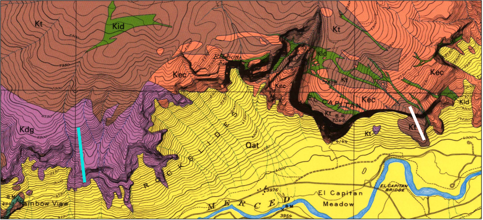
- Let’s find an area where they contact each other so we can compare their gradients. Find this region on your map:
- Determine the gradient (feet/mile) of the Taft Granite (white line). Use the graphic scale on the main map to evaluate your distance (use miles). Use the topo lines to evaluate change in elevation (use feet). Hint: Gradient= change in elevation/distance. Show your work. Gradient of Taft Granite:
- Determine the gradient (feet/mile) of the Rockslides (turquoise line). Use the graphic scale on the main map to evaluate your distance (use miles). Use the topo lines to evaluate change in elevation (use feet). Hint: Gradient= change in elevation/distance. Show your work. Gradient of Diorite of the Rockslides:
- According to your data, which igneous composition is more susceptible to weathering? Mafic or felsic?

Let’s look at some patterns in the granitic rocks.
22. What is the pattern in geologic ages? What happens as you move from west to east?
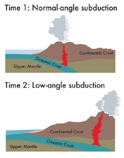
This happens because of the angle of subduction. The steeper the slab is subducting, the closer to the continental margin the intrusive activity will be (see figure).

Figure 16.18: Figure to use for Question 23, Activity 16G.
23. Subduction angle is controlled by a variety of things, one of which is subduction rate. The faster the subduction, the steeper the angle. Over time during the Cretaceous, what was happening to subduction rates (i.e. were they increasing or decreasing)?
Attributions
- Figure 16.17: Derivative of “Bedrock Geologic Map of Yosemite Valley, Yosemite National Park, California” (Public Domain; Frank C. Calkins/USGS) by Chloe Branciforte
- Figure 16.18: “Subduction Angles” (CC-BY 4.0; Emily Haddad, own work)


