
19.4: Landforms of Alpine Glaciation
- Page ID
- 17211

\( \newcommand{\vecs}[1]{\overset { \scriptstyle \rightharpoonup} {\mathbf{#1}} } \)
\( \newcommand{\vecd}[1]{\overset{-\!-\!\rightharpoonup}{\vphantom{a}\smash {#1}}} \)
\( \newcommand{\id}{\mathrm{id}}\) \( \newcommand{\Span}{\mathrm{span}}\)
( \newcommand{\kernel}{\mathrm{null}\,}\) \( \newcommand{\range}{\mathrm{range}\,}\)
\( \newcommand{\RealPart}{\mathrm{Re}}\) \( \newcommand{\ImaginaryPart}{\mathrm{Im}}\)
\( \newcommand{\Argument}{\mathrm{Arg}}\) \( \newcommand{\norm}[1]{\| #1 \|}\)
\( \newcommand{\inner}[2]{\langle #1, #2 \rangle}\)
\( \newcommand{\Span}{\mathrm{span}}\)
\( \newcommand{\id}{\mathrm{id}}\)
\( \newcommand{\Span}{\mathrm{span}}\)
\( \newcommand{\kernel}{\mathrm{null}\,}\)
\( \newcommand{\range}{\mathrm{range}\,}\)
\( \newcommand{\RealPart}{\mathrm{Re}}\)
\( \newcommand{\ImaginaryPart}{\mathrm{Im}}\)
\( \newcommand{\Argument}{\mathrm{Arg}}\)
\( \newcommand{\norm}[1]{\| #1 \|}\)
\( \newcommand{\inner}[2]{\langle #1, #2 \rangle}\)
\( \newcommand{\Span}{\mathrm{span}}\) \( \newcommand{\AA}{\unicode[.8,0]{x212B}}\)
\( \newcommand{\vectorA}[1]{\vec{#1}} % arrow\)
\( \newcommand{\vectorAt}[1]{\vec{\text{#1}}} % arrow\)
\( \newcommand{\vectorB}[1]{\overset { \scriptstyle \rightharpoonup} {\mathbf{#1}} } \)
\( \newcommand{\vectorC}[1]{\textbf{#1}} \)
\( \newcommand{\vectorD}[1]{\overrightarrow{#1}} \)
\( \newcommand{\vectorDt}[1]{\overrightarrow{\text{#1}}} \)
\( \newcommand{\vectE}[1]{\overset{-\!-\!\rightharpoonup}{\vphantom{a}\smash{\mathbf {#1}}}} \)
\( \newcommand{\vecs}[1]{\overset { \scriptstyle \rightharpoonup} {\mathbf{#1}} } \)
\( \newcommand{\vecd}[1]{\overset{-\!-\!\rightharpoonup}{\vphantom{a}\smash {#1}}} \)
\(\newcommand{\avec}{\mathbf a}\) \(\newcommand{\bvec}{\mathbf b}\) \(\newcommand{\cvec}{\mathbf c}\) \(\newcommand{\dvec}{\mathbf d}\) \(\newcommand{\dtil}{\widetilde{\mathbf d}}\) \(\newcommand{\evec}{\mathbf e}\) \(\newcommand{\fvec}{\mathbf f}\) \(\newcommand{\nvec}{\mathbf n}\) \(\newcommand{\pvec}{\mathbf p}\) \(\newcommand{\qvec}{\mathbf q}\) \(\newcommand{\svec}{\mathbf s}\) \(\newcommand{\tvec}{\mathbf t}\) \(\newcommand{\uvec}{\mathbf u}\) \(\newcommand{\vvec}{\mathbf v}\) \(\newcommand{\wvec}{\mathbf w}\) \(\newcommand{\xvec}{\mathbf x}\) \(\newcommand{\yvec}{\mathbf y}\) \(\newcommand{\zvec}{\mathbf z}\) \(\newcommand{\rvec}{\mathbf r}\) \(\newcommand{\mvec}{\mathbf m}\) \(\newcommand{\zerovec}{\mathbf 0}\) \(\newcommand{\onevec}{\mathbf 1}\) \(\newcommand{\real}{\mathbb R}\) \(\newcommand{\twovec}[2]{\left[\begin{array}{r}#1 \\ #2 \end{array}\right]}\) \(\newcommand{\ctwovec}[2]{\left[\begin{array}{c}#1 \\ #2 \end{array}\right]}\) \(\newcommand{\threevec}[3]{\left[\begin{array}{r}#1 \\ #2 \\ #3 \end{array}\right]}\) \(\newcommand{\cthreevec}[3]{\left[\begin{array}{c}#1 \\ #2 \\ #3 \end{array}\right]}\) \(\newcommand{\fourvec}[4]{\left[\begin{array}{r}#1 \\ #2 \\ #3 \\ #4 \end{array}\right]}\) \(\newcommand{\cfourvec}[4]{\left[\begin{array}{c}#1 \\ #2 \\ #3 \\ #4 \end{array}\right]}\) \(\newcommand{\fivevec}[5]{\left[\begin{array}{r}#1 \\ #2 \\ #3 \\ #4 \\ #5 \\ \end{array}\right]}\) \(\newcommand{\cfivevec}[5]{\left[\begin{array}{c}#1 \\ #2 \\ #3 \\ #4 \\ #5 \\ \end{array}\right]}\) \(\newcommand{\mattwo}[4]{\left[\begin{array}{rr}#1 \amp #2 \\ #3 \amp #4 \\ \end{array}\right]}\) \(\newcommand{\laspan}[1]{\text{Span}\{#1\}}\) \(\newcommand{\bcal}{\cal B}\) \(\newcommand{\ccal}{\cal C}\) \(\newcommand{\scal}{\cal S}\) \(\newcommand{\wcal}{\cal W}\) \(\newcommand{\ecal}{\cal E}\) \(\newcommand{\coords}[2]{\left\{#1\right\}_{#2}}\) \(\newcommand{\gray}[1]{\color{gray}{#1}}\) \(\newcommand{\lgray}[1]{\color{lightgray}{#1}}\) \(\newcommand{\rank}{\operatorname{rank}}\) \(\newcommand{\row}{\text{Row}}\) \(\newcommand{\col}{\text{Col}}\) \(\renewcommand{\row}{\text{Row}}\) \(\newcommand{\nul}{\text{Nul}}\) \(\newcommand{\var}{\text{Var}}\) \(\newcommand{\corr}{\text{corr}}\) \(\newcommand{\len}[1]{\left|#1\right|}\) \(\newcommand{\bbar}{\overline{\bvec}}\) \(\newcommand{\bhat}{\widehat{\bvec}}\) \(\newcommand{\bperp}{\bvec^\perp}\) \(\newcommand{\xhat}{\widehat{\xvec}}\) \(\newcommand{\vhat}{\widehat{\vvec}}\) \(\newcommand{\uhat}{\widehat{\uvec}}\) \(\newcommand{\what}{\widehat{\wvec}}\) \(\newcommand{\Sighat}{\widehat{\Sigma}}\) \(\newcommand{\lt}{<}\) \(\newcommand{\gt}{>}\) \(\newcommand{\amp}{&}\) \(\definecolor{fillinmathshade}{gray}{0.9}\)A region altered by an alpine glacier is depicted in Figure \(\PageIndex{1}\). Refer to this diagram as you read about the various landforms created by alpine glaciers.

The headwaters of stream tributaries serve as the birth place for alpine glaciers. The headwaters of tributary valleys lie at the highest elevation in the drainage basin of a mountain stream. Here snow accumulates to great thickness and starts to move down valley. As it moves outward from the zone of accumulation, the glacier scours away at the valley sides. The material eroded from the surface is transported the length of the glacier to the zone of ablation, where it is deposited.
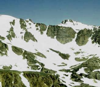
At the zone of accumulation where ice is accumulating, the glacier plucks rock from the head of the valley. The erosion creates a huge, amphitheater-like depression at the valley head called a cirque. ![]() After the glacier melts away a tarn, or cirque lake
After the glacier melts away a tarn, or cirque lake ![]() , may be found on the floor. Surrounding the floor are the massive curved side and headwalls of the cirque. A headwall crevasse known as a bergschrund forms where snow and compacted firn pull away from ice that remains frozen to the rock of the headwall. As alpine glaciers erode headward, they narrow the upland between ice sheets from opposite directions and a pyramid-shaped peak, called a horn is created.
, may be found on the floor. Surrounding the floor are the massive curved side and headwalls of the cirque. A headwall crevasse known as a bergschrund forms where snow and compacted firn pull away from ice that remains frozen to the rock of the headwall. As alpine glaciers erode headward, they narrow the upland between ice sheets from opposite directions and a pyramid-shaped peak, called a horn is created.![]() When two adjacent cirques on opposite sides of a divide cut back and remove part of it, a sharp-edge notch or pass called a col is formed.
When two adjacent cirques on opposite sides of a divide cut back and remove part of it, a sharp-edge notch or pass called a col is formed.
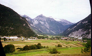
The massive amount of ice that fills the main valley is from that which accumulates at the head of the valley plus that from all the tributary valleys that enter it. The enormous weight of the ice erodes away at the valley sides. The V-shape of the pre-existing stream valley now takes on the characteristic U-shaped of a glacial trough. ![]()
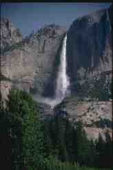
Prior to glaciation, tributary streams entered the main stream at the elevation of the main channel. But during glaciation, tributary glaciers feeding into the main valley are smaller and do not erode their valleys as deep as the glacier that occupies the main valley. Tributary valleys are left hanging at a higher elevation above the main valley floor as a result of more intensive downward cutting by the main valley glacier. These hanging valleys create spectacular waterfalls. ![]()
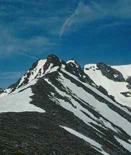
Glaciers in adjacent tributary valleys scour away at the upland between them (an interfluve). As erosion of the interfluve continues, it is narrows into a serrated ridge known as an arête. ![]() As mountain glaciers flow down valley they encounter exposed bed rock of varying resistance to erosion. The glacier will erode down into weaker rock but have to flow over the stronger rock. This creates a series of rock steps
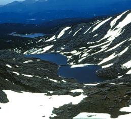
As mountain glaciers flow down valley they encounter exposed bed rock of varying resistance to erosion. The glacier will erode down into weaker rock but have to flow over the stronger rock. This creates a series of rock steps ![]() composed of the more resistant rocks with small depression behind them where the weaker rock is exposed. Often these depressions are occupied with water to form staircase lakes. Connected by a small stream these lakes are also know as paternoster lakes.
composed of the more resistant rocks with small depression behind them where the weaker rock is exposed. Often these depressions are occupied with water to form staircase lakes. Connected by a small stream these lakes are also know as paternoster lakes.
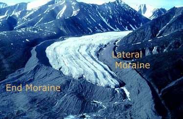
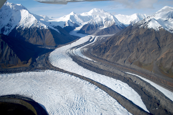
Glacial till is deposited along the valley sides as lateral moraine. ![]() Till is transported and deposited at the nose of the glacier as an end moraine. The end or terminal moraine marks the furthest advance of the glacier. Behind the terminal moraine are found recessional moraines indicating positions of the glacier front during times of retreat. When lateral moraines merge upon entering a main glacial trough, medial moraines
Till is transported and deposited at the nose of the glacier as an end moraine. The end or terminal moraine marks the furthest advance of the glacier. Behind the terminal moraine are found recessional moraines indicating positions of the glacier front during times of retreat. When lateral moraines merge upon entering a main glacial trough, medial moraines ![]() are formed and run the length of the glacier.
are formed and run the length of the glacier.
Video: "Hanging Glaciers" (Courtesy of UBC Virtual Soil Learning Resources)