
19.1: Glaciation
- Page ID
- 17206

\( \newcommand{\vecs}[1]{\overset { \scriptstyle \rightharpoonup} {\mathbf{#1}} } \)
\( \newcommand{\vecd}[1]{\overset{-\!-\!\rightharpoonup}{\vphantom{a}\smash {#1}}} \)
\( \newcommand{\dsum}{\displaystyle\sum\limits} \)
\( \newcommand{\dint}{\displaystyle\int\limits} \)
\( \newcommand{\dlim}{\displaystyle\lim\limits} \)
\( \newcommand{\id}{\mathrm{id}}\) \( \newcommand{\Span}{\mathrm{span}}\)
( \newcommand{\kernel}{\mathrm{null}\,}\) \( \newcommand{\range}{\mathrm{range}\,}\)
\( \newcommand{\RealPart}{\mathrm{Re}}\) \( \newcommand{\ImaginaryPart}{\mathrm{Im}}\)
\( \newcommand{\Argument}{\mathrm{Arg}}\) \( \newcommand{\norm}[1]{\| #1 \|}\)
\( \newcommand{\inner}[2]{\langle #1, #2 \rangle}\)
\( \newcommand{\Span}{\mathrm{span}}\)
\( \newcommand{\id}{\mathrm{id}}\)
\( \newcommand{\Span}{\mathrm{span}}\)
\( \newcommand{\kernel}{\mathrm{null}\,}\)
\( \newcommand{\range}{\mathrm{range}\,}\)
\( \newcommand{\RealPart}{\mathrm{Re}}\)
\( \newcommand{\ImaginaryPart}{\mathrm{Im}}\)
\( \newcommand{\Argument}{\mathrm{Arg}}\)
\( \newcommand{\norm}[1]{\| #1 \|}\)
\( \newcommand{\inner}[2]{\langle #1, #2 \rangle}\)
\( \newcommand{\Span}{\mathrm{span}}\) \( \newcommand{\AA}{\unicode[.8,0]{x212B}}\)
\( \newcommand{\vectorA}[1]{\vec{#1}} % arrow\)
\( \newcommand{\vectorAt}[1]{\vec{\text{#1}}} % arrow\)
\( \newcommand{\vectorB}[1]{\overset { \scriptstyle \rightharpoonup} {\mathbf{#1}} } \)
\( \newcommand{\vectorC}[1]{\textbf{#1}} \)
\( \newcommand{\vectorD}[1]{\overrightarrow{#1}} \)
\( \newcommand{\vectorDt}[1]{\overrightarrow{\text{#1}}} \)
\( \newcommand{\vectE}[1]{\overset{-\!-\!\rightharpoonup}{\vphantom{a}\smash{\mathbf {#1}}}} \)
\( \newcommand{\vecs}[1]{\overset { \scriptstyle \rightharpoonup} {\mathbf{#1}} } \)
\(\newcommand{\longvect}{\overrightarrow}\)
\( \newcommand{\vecd}[1]{\overset{-\!-\!\rightharpoonup}{\vphantom{a}\smash {#1}}} \)
\(\newcommand{\avec}{\mathbf a}\) \(\newcommand{\bvec}{\mathbf b}\) \(\newcommand{\cvec}{\mathbf c}\) \(\newcommand{\dvec}{\mathbf d}\) \(\newcommand{\dtil}{\widetilde{\mathbf d}}\) \(\newcommand{\evec}{\mathbf e}\) \(\newcommand{\fvec}{\mathbf f}\) \(\newcommand{\nvec}{\mathbf n}\) \(\newcommand{\pvec}{\mathbf p}\) \(\newcommand{\qvec}{\mathbf q}\) \(\newcommand{\svec}{\mathbf s}\) \(\newcommand{\tvec}{\mathbf t}\) \(\newcommand{\uvec}{\mathbf u}\) \(\newcommand{\vvec}{\mathbf v}\) \(\newcommand{\wvec}{\mathbf w}\) \(\newcommand{\xvec}{\mathbf x}\) \(\newcommand{\yvec}{\mathbf y}\) \(\newcommand{\zvec}{\mathbf z}\) \(\newcommand{\rvec}{\mathbf r}\) \(\newcommand{\mvec}{\mathbf m}\) \(\newcommand{\zerovec}{\mathbf 0}\) \(\newcommand{\onevec}{\mathbf 1}\) \(\newcommand{\real}{\mathbb R}\) \(\newcommand{\twovec}[2]{\left[\begin{array}{r}#1 \\ #2 \end{array}\right]}\) \(\newcommand{\ctwovec}[2]{\left[\begin{array}{c}#1 \\ #2 \end{array}\right]}\) \(\newcommand{\threevec}[3]{\left[\begin{array}{r}#1 \\ #2 \\ #3 \end{array}\right]}\) \(\newcommand{\cthreevec}[3]{\left[\begin{array}{c}#1 \\ #2 \\ #3 \end{array}\right]}\) \(\newcommand{\fourvec}[4]{\left[\begin{array}{r}#1 \\ #2 \\ #3 \\ #4 \end{array}\right]}\) \(\newcommand{\cfourvec}[4]{\left[\begin{array}{c}#1 \\ #2 \\ #3 \\ #4 \end{array}\right]}\) \(\newcommand{\fivevec}[5]{\left[\begin{array}{r}#1 \\ #2 \\ #3 \\ #4 \\ #5 \\ \end{array}\right]}\) \(\newcommand{\cfivevec}[5]{\left[\begin{array}{c}#1 \\ #2 \\ #3 \\ #4 \\ #5 \\ \end{array}\right]}\) \(\newcommand{\mattwo}[4]{\left[\begin{array}{rr}#1 \amp #2 \\ #3 \amp #4 \\ \end{array}\right]}\) \(\newcommand{\laspan}[1]{\text{Span}\{#1\}}\) \(\newcommand{\bcal}{\cal B}\) \(\newcommand{\ccal}{\cal C}\) \(\newcommand{\scal}{\cal S}\) \(\newcommand{\wcal}{\cal W}\) \(\newcommand{\ecal}{\cal E}\) \(\newcommand{\coords}[2]{\left\{#1\right\}_{#2}}\) \(\newcommand{\gray}[1]{\color{gray}{#1}}\) \(\newcommand{\lgray}[1]{\color{lightgray}{#1}}\) \(\newcommand{\rank}{\operatorname{rank}}\) \(\newcommand{\row}{\text{Row}}\) \(\newcommand{\col}{\text{Col}}\) \(\renewcommand{\row}{\text{Row}}\) \(\newcommand{\nul}{\text{Nul}}\) \(\newcommand{\var}{\text{Var}}\) \(\newcommand{\corr}{\text{corr}}\) \(\newcommand{\len}[1]{\left|#1\right|}\) \(\newcommand{\bbar}{\overline{\bvec}}\) \(\newcommand{\bhat}{\widehat{\bvec}}\) \(\newcommand{\bperp}{\bvec^\perp}\) \(\newcommand{\xhat}{\widehat{\xvec}}\) \(\newcommand{\vhat}{\widehat{\vvec}}\) \(\newcommand{\uhat}{\widehat{\uvec}}\) \(\newcommand{\what}{\widehat{\wvec}}\) \(\newcommand{\Sighat}{\widehat{\Sigma}}\) \(\newcommand{\lt}{<}\) \(\newcommand{\gt}{>}\) \(\newcommand{\amp}{&}\) \(\definecolor{fillinmathshade}{gray}{0.9}\)A glacier is a natural accumulation of land ice showing movement at some time. Many times during Earth's history, great ice sheets waxed and waned over the surface. What caused these periods of glaciation is still not fully understood and no single reason will probably be found.
Causes of glaciation
The onset of a period or stage of glaciation is due to a change in Earth temperature and circulation. It is generally accepted that a global decrease of 4o to 5oC, especially during the summer, and a substantial increase in the amount of snowfall in subarctic and arctic regions is necessary for the onset of a glacial episode. Several theories have been proposed for such a change in climate -- reductions in solar radiation due to meteorite collisions with the Earth, increased volcanism, the shifting location of continents, and the uplift of vast mountain regions. Milutin Milankovitch ![]() proposed one of the most significant theories to account for climate change by variations in Earth orbit. Changes in the eccentricity of earth orbit, the degree of deviation of the orbit from a perfect circular path, is thought to cause the necessary change in insolation to decrease global temperatures. Recall that the Earth's orbit is elliptical, but over periods of 100,000 years the shape varies. The changes in orbit have been correlated with ocean sediments that record the history of glacial stages. The cyclical nature of warming and cooling correspond well with the estimated dates of glacial and interglacial periods. In addition to the change in orbit, the Earth "wobbles" on its axis which alters the amount of insolation reaching the surface of the Earth. [For more about the causes and stages of glaciation in earth history.
proposed one of the most significant theories to account for climate change by variations in Earth orbit. Changes in the eccentricity of earth orbit, the degree of deviation of the orbit from a perfect circular path, is thought to cause the necessary change in insolation to decrease global temperatures. Recall that the Earth's orbit is elliptical, but over periods of 100,000 years the shape varies. The changes in orbit have been correlated with ocean sediments that record the history of glacial stages. The cyclical nature of warming and cooling correspond well with the estimated dates of glacial and interglacial periods. In addition to the change in orbit, the Earth "wobbles" on its axis which alters the amount of insolation reaching the surface of the Earth. [For more about the causes and stages of glaciation in earth history.
Video: Milankovitch cycles precession and obliquity: How changes in Earth's rotation can effect Earth's seasons and climate
Video: Is An Ice Age Coming? (Courtesy National Geographic)
Anatomy of a Glacier
Whatever the cause, the main reason glacial advances are initiated is that winter accumulation exceeds the summer loss of snow over a long period of time. Snow metamorphoses into glacial ice under the increasing pressure of accumulated layers of snow. It first changes to a granular form called firn, and ultimately into ice. Glacial ice sometimes looks blue because it absorbs all colors of the visible light spectrum except blue, which it transmits and hence its blue appearance. Glacier ice may also appear white because some ice is fractured with pockets of air that indiscriminately scatters the visible light spectrum.
The mass balance of a glacier determines if it will advance across the surface or not. The mass balance is determined by the amount of gain and loss of ice from the glacier. The mass balance is positive when it accumulates more ice than it loses. A glacier has a negative mass balance if it loses more ice than it gains.
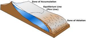
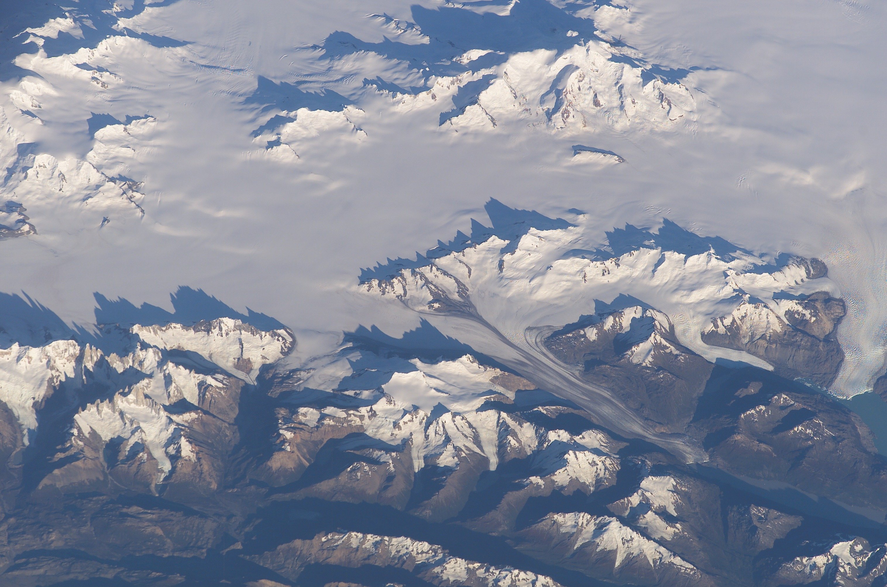
Glaciers form in the zone of accumulation, the portion of the glacier over which accumulation exceeds ablation. Ablation is the loss of ice (or snow) from the glacier. Ablation includes sublimation, wind erosion, melting, and evaporation. The zone of accumulation for the large continental ice sheets resides at high latitudes. For mountain glaciers, the zone of accumulation is at a high altitude where temperatures are cold prevent complete summertime melt. The zone of ablation is where loss of ice mass is greater than accumulation. The boundary between these two zones is the firn or equilibrium line. If accumulation exceeds ablation the glacier will grow. If ablation exceeds accumulation, the glacier will retreat by melting in place. You can approximate the location of the equilibrium line by examining an aerial photograph. The glacier looks dirtier below the equilibrium line as glacial sediment is exposed on top of the ice. Above the line it is more white because fresh snow usually covers the surface. Listen to a glacier refreezing (Antarctica 2000).
Video: "Glacier Power" Go inside a glacier to to help understand power of a glacier (Courtesy of National Geographic)
Glacier Movement
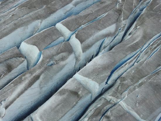
Once the ice reaches a thickness of about 20 meters (66 ft) it will begin to move under the pressure of its weight. Glaciers move across the surface by internal deformation and basal slip. Under the weight of accumulating ice,the ice is deformed and begins to move by pseudo-plastic flow. Glaciers slip over the surface lubricated by meltwater at their base. Generally speaking, flow velocity in a glacier is greatest near the surface of the ice and decreases towards the bottom. The surface moves faster than the base does due to internal deformation and basal slipping. The actual forward movement of a particle of ice in the glacier is about 1,000 feet per year. A typical glacier will move at about 10 inches a day, though some move more rapidly like Greenland's Jakobshavn glacier. [ View "Fastest Glacier" from Nova scienceNow] Variations in the speed of the ice caused by surface irregularities results in differential expansion and compression of the ice and the development of crevasses. A deadly situation for hikers, crevasses can open and close with little warning.
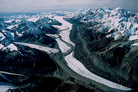
A glacial surge occurs as an abrupt movement that can cover tens of meters per day. The exact cause is not well-known, but may result from water pressure building at the base which "floats" the glacier. In 1986 the Hubbard Glacier surged across the mouth of the Russell fjord in Alaska cutting it off from Yakut Bay. Glacier movement exceeded 112 feet per day, compared to a normal rate of 10 inches per day! The Black Rapids Glacier, AK in \(\PageIndex{4}\) is a surging glacier. Tributary glaciers enter the main valley from the left. Massive amounts of glacial sediment have been deposited along the sides of the glacier and up against the valley walls. The tell-tale sign of a surging glacier are the looped moraines that snake their way across the ice.
Types of glaciers
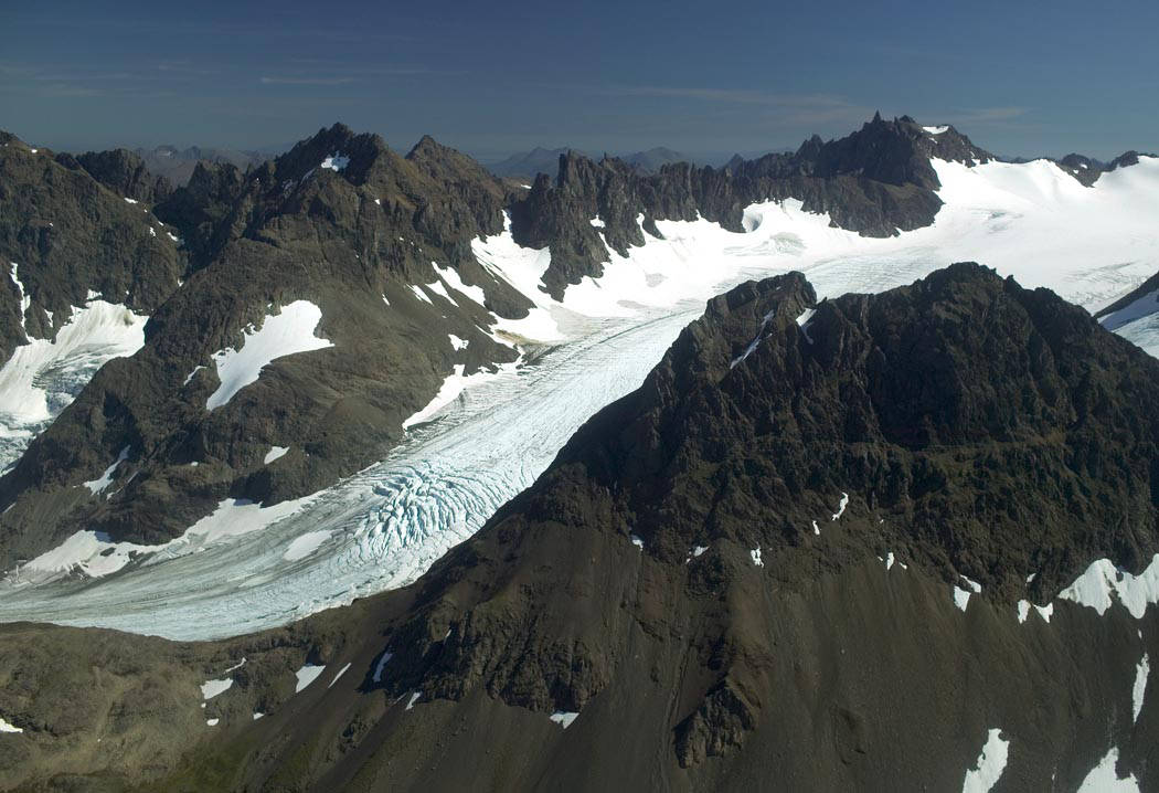
Two major categories of glaciers are alpine and continental glaciers. Alpine glaciers are those that form at high altitudes in mountainous regions where the temperature is favorable for their formation. There are four types of alpine glaciers, cirque, valley, piedmont, and ice field shown. They range from glaciers a few hundred square meters to vast expanses that smother whole mountain ranges. Cirque glaciers form in bowl-shaped depressions, called cirques, scoured into the side of a mountain. Weathering and erosion  loosen bedrock at the head of of a preexisting stream valley as ice accumulates. As erosion proceeds, a depression forms in which the cirque glacier continues to grow. Valley glaciers fill former stream valleys with ice as they push outward from their zone of accumulation. Cirque glaciers that grow beyond the limits of the depression in which they form spill out to become valley glaciers. Piedmont glaciers form when valley glaciers flow out of canyons onto the lowland adjacent to a mountain front. Ice fields are confined to large basins or plateaus having tall mountain peaks called nunataks protruding above the ice. Ice fields feed alpine valley glaciers.
Continental glaciers are vast, continuous masses of ice that originate in high latitudes and cover portions of a continent or island Figure \(\PageIndex{7}\)). Continental glaciers flow outwards in all directions from thicker ice near the center of the ice mass towards the thinner periphery of the ice mass. Continental glaciers are considered "unconfined glaciers" because they flow over a landscape and generally are not affected by it.
There are three types of continental glaciers, ice sheets, ice caps, and outlet. An ice sheet covers an area larger than 50,000 square kilometers (19,305 sq. mil.). Greenland and Antarctica and are covered by massive ice sheets today. The Greenland ice sheet occupies 1,710,000 square kilometers (660,000 sq. mi), nearly 80% of Greenland. The ice sheet is over 3 km (1.9 mi) at its thickest point. The Antarctic ice sheet covers nearly 98% of the continent. With almost 14 million square kilometers (5.4 million sq. miles) of ice, the Antarctic ice sheet is the largest single mass of ice on Earth. The ice sheet has a maximum thickness of 4.78 kilometers (2.97 miles).
An ice cap is a dome-shaped mass of ice of less than 50,000 square kilometers (approximately 19,000 square miles) and usually covering a highland area. Though covering a mountainous region, an ice cap is categorized as a type of continental glacier because it is not constrained by the topography. Think of an ice cap as a precursor to an ice sheet. The Vatnajokull ice cap in Iceland, the large mass of ice in Figure B, sits on top of three active volcanoes. The bright green lakes and coastal waters are the result of very fine sediment eroded by glaciers and washed out in glacial meltwater. Outlet glaciers are similar to valley glaciers as they are confined by the topography but originate from an ice cap.
Video: Antarctica 2009 (Courtesy NASA). The Nov. 4, 2009 Operation Ice Bridge flight criss-crossed the Antarctic Peninsula to survey glaciers flowing down mountain valleys to feed the floating ice shelves.