
18.5: Landforms of Alluvial Rivers
- Page ID
- 17202

\( \newcommand{\vecs}[1]{\overset { \scriptstyle \rightharpoonup} {\mathbf{#1}} } \)
\( \newcommand{\vecd}[1]{\overset{-\!-\!\rightharpoonup}{\vphantom{a}\smash {#1}}} \)
\( \newcommand{\id}{\mathrm{id}}\) \( \newcommand{\Span}{\mathrm{span}}\)
( \newcommand{\kernel}{\mathrm{null}\,}\) \( \newcommand{\range}{\mathrm{range}\,}\)
\( \newcommand{\RealPart}{\mathrm{Re}}\) \( \newcommand{\ImaginaryPart}{\mathrm{Im}}\)
\( \newcommand{\Argument}{\mathrm{Arg}}\) \( \newcommand{\norm}[1]{\| #1 \|}\)
\( \newcommand{\inner}[2]{\langle #1, #2 \rangle}\)
\( \newcommand{\Span}{\mathrm{span}}\)
\( \newcommand{\id}{\mathrm{id}}\)
\( \newcommand{\Span}{\mathrm{span}}\)
\( \newcommand{\kernel}{\mathrm{null}\,}\)
\( \newcommand{\range}{\mathrm{range}\,}\)
\( \newcommand{\RealPart}{\mathrm{Re}}\)
\( \newcommand{\ImaginaryPart}{\mathrm{Im}}\)
\( \newcommand{\Argument}{\mathrm{Arg}}\)
\( \newcommand{\norm}[1]{\| #1 \|}\)
\( \newcommand{\inner}[2]{\langle #1, #2 \rangle}\)
\( \newcommand{\Span}{\mathrm{span}}\) \( \newcommand{\AA}{\unicode[.8,0]{x212B}}\)
\( \newcommand{\vectorA}[1]{\vec{#1}} % arrow\)
\( \newcommand{\vectorAt}[1]{\vec{\text{#1}}} % arrow\)
\( \newcommand{\vectorB}[1]{\overset { \scriptstyle \rightharpoonup} {\mathbf{#1}} } \)
\( \newcommand{\vectorC}[1]{\textbf{#1}} \)
\( \newcommand{\vectorD}[1]{\overrightarrow{#1}} \)
\( \newcommand{\vectorDt}[1]{\overrightarrow{\text{#1}}} \)
\( \newcommand{\vectE}[1]{\overset{-\!-\!\rightharpoonup}{\vphantom{a}\smash{\mathbf {#1}}}} \)
\( \newcommand{\vecs}[1]{\overset { \scriptstyle \rightharpoonup} {\mathbf{#1}} } \)
\( \newcommand{\vecd}[1]{\overset{-\!-\!\rightharpoonup}{\vphantom{a}\smash {#1}}} \)
\(\newcommand{\avec}{\mathbf a}\) \(\newcommand{\bvec}{\mathbf b}\) \(\newcommand{\cvec}{\mathbf c}\) \(\newcommand{\dvec}{\mathbf d}\) \(\newcommand{\dtil}{\widetilde{\mathbf d}}\) \(\newcommand{\evec}{\mathbf e}\) \(\newcommand{\fvec}{\mathbf f}\) \(\newcommand{\nvec}{\mathbf n}\) \(\newcommand{\pvec}{\mathbf p}\) \(\newcommand{\qvec}{\mathbf q}\) \(\newcommand{\svec}{\mathbf s}\) \(\newcommand{\tvec}{\mathbf t}\) \(\newcommand{\uvec}{\mathbf u}\) \(\newcommand{\vvec}{\mathbf v}\) \(\newcommand{\wvec}{\mathbf w}\) \(\newcommand{\xvec}{\mathbf x}\) \(\newcommand{\yvec}{\mathbf y}\) \(\newcommand{\zvec}{\mathbf z}\) \(\newcommand{\rvec}{\mathbf r}\) \(\newcommand{\mvec}{\mathbf m}\) \(\newcommand{\zerovec}{\mathbf 0}\) \(\newcommand{\onevec}{\mathbf 1}\) \(\newcommand{\real}{\mathbb R}\) \(\newcommand{\twovec}[2]{\left[\begin{array}{r}#1 \\ #2 \end{array}\right]}\) \(\newcommand{\ctwovec}[2]{\left[\begin{array}{c}#1 \\ #2 \end{array}\right]}\) \(\newcommand{\threevec}[3]{\left[\begin{array}{r}#1 \\ #2 \\ #3 \end{array}\right]}\) \(\newcommand{\cthreevec}[3]{\left[\begin{array}{c}#1 \\ #2 \\ #3 \end{array}\right]}\) \(\newcommand{\fourvec}[4]{\left[\begin{array}{r}#1 \\ #2 \\ #3 \\ #4 \end{array}\right]}\) \(\newcommand{\cfourvec}[4]{\left[\begin{array}{c}#1 \\ #2 \\ #3 \\ #4 \end{array}\right]}\) \(\newcommand{\fivevec}[5]{\left[\begin{array}{r}#1 \\ #2 \\ #3 \\ #4 \\ #5 \\ \end{array}\right]}\) \(\newcommand{\cfivevec}[5]{\left[\begin{array}{c}#1 \\ #2 \\ #3 \\ #4 \\ #5 \\ \end{array}\right]}\) \(\newcommand{\mattwo}[4]{\left[\begin{array}{rr}#1 \amp #2 \\ #3 \amp #4 \\ \end{array}\right]}\) \(\newcommand{\laspan}[1]{\text{Span}\{#1\}}\) \(\newcommand{\bcal}{\cal B}\) \(\newcommand{\ccal}{\cal C}\) \(\newcommand{\scal}{\cal S}\) \(\newcommand{\wcal}{\cal W}\) \(\newcommand{\ecal}{\cal E}\) \(\newcommand{\coords}[2]{\left\{#1\right\}_{#2}}\) \(\newcommand{\gray}[1]{\color{gray}{#1}}\) \(\newcommand{\lgray}[1]{\color{lightgray}{#1}}\) \(\newcommand{\rank}{\operatorname{rank}}\) \(\newcommand{\row}{\text{Row}}\) \(\newcommand{\col}{\text{Col}}\) \(\renewcommand{\row}{\text{Row}}\) \(\newcommand{\nul}{\text{Nul}}\) \(\newcommand{\var}{\text{Var}}\) \(\newcommand{\corr}{\text{corr}}\) \(\newcommand{\len}[1]{\left|#1\right|}\) \(\newcommand{\bbar}{\overline{\bvec}}\) \(\newcommand{\bhat}{\widehat{\bvec}}\) \(\newcommand{\bperp}{\bvec^\perp}\) \(\newcommand{\xhat}{\widehat{\xvec}}\) \(\newcommand{\vhat}{\widehat{\vvec}}\) \(\newcommand{\uhat}{\widehat{\uvec}}\) \(\newcommand{\what}{\widehat{\wvec}}\) \(\newcommand{\Sighat}{\widehat{\Sigma}}\) \(\newcommand{\lt}{<}\) \(\newcommand{\gt}{>}\) \(\newcommand{\amp}{&}\) \(\definecolor{fillinmathshade}{gray}{0.9}\)Rivers that have reached base level develop broad valleys by erosion caused by meandering channels. The stream channel cuts through and redistributes its sediment or alluvium that lines the area bordering the stream.
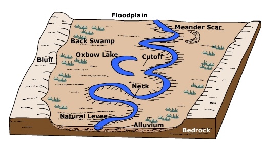
Floodplain

A floodplain is the relatively flat area that borders a stream which is periodically inundated with water during high flow periods. When excess runoff causes the stream discharge to increase beyond the capacity of the channel, water spills out onto the floodplain. Increasing the cross-sectional area of stream flow causes a decrease in stream velocity. The resulting decrease in velocity causes sediment to deposit as alluvium on the floodplain ![]() . These alluvial deposits are often rich in nutrients and thus naturally fertilize floodplain soils. Floodplain agriculture has given rise to many of the great world civilizations.
. These alluvial deposits are often rich in nutrients and thus naturally fertilize floodplain soils. Floodplain agriculture has given rise to many of the great world civilizations.
Natural Levee
A natural levee ![]() is an narrow ridge of alluvium deposited at the side of the channel. During high discharge periods when the stream floods, coarse sediment settles out near the stream channel and grades to finer material further away. The over bank deposits of alluvium are often rich sources of nutrients for soils developed on the floodplain. Because floodplain soils are usually quite fertile, humans have inhabited them for years. To prevent flooding, artificial levees are built close to the channel, typically higher than natural levees. Confining the flood discharge to a small area increases the velocity of flow. The levees of the Mississippi River increase the flow velocity near the mouth as it enters the Gulf of Mexico. As a result, sediment is shot into the Gulf rather than being deposited near the mouth building the river's famous 'bird's foot' delta.
is an narrow ridge of alluvium deposited at the side of the channel. During high discharge periods when the stream floods, coarse sediment settles out near the stream channel and grades to finer material further away. The over bank deposits of alluvium are often rich sources of nutrients for soils developed on the floodplain. Because floodplain soils are usually quite fertile, humans have inhabited them for years. To prevent flooding, artificial levees are built close to the channel, typically higher than natural levees. Confining the flood discharge to a small area increases the velocity of flow. The levees of the Mississippi River increase the flow velocity near the mouth as it enters the Gulf of Mexico. As a result, sediment is shot into the Gulf rather than being deposited near the mouth building the river's famous 'bird's foot' delta.
Back swamp

Back swamps are located some distance away from the stream channel on the floodplain. When water spills over onto the floodplain, the heaviest material drops out first and finest material is carried a greater distance. The fine grained alluvium holds much water and drains rather slowly creating wetland areas. Back swamps are important "sponges" that retain water that might cause severe flooding downstream. ![]()
Meander

A meander ![]() is a bend in a stream. Vertical channel cutting is typical of the early stages of stream system evolution and hence, meandering channel pattern is negligible. However during later stages as base level is achieved and channel equilibrium is approached, lateral migration of the stream channel is more prevalent. Meanders grow both laterally and in the down stream direction. As water flows into a meander it takes on a helical or spiral flow which determines where erosion and deposition is concentrated. Centrifugal force draws water toward the outside bank (cut bank) causing erosion. Sediment eroded from the outside bank is deposited on the inside bank and transported downstream.
is a bend in a stream. Vertical channel cutting is typical of the early stages of stream system evolution and hence, meandering channel pattern is negligible. However during later stages as base level is achieved and channel equilibrium is approached, lateral migration of the stream channel is more prevalent. Meanders grow both laterally and in the down stream direction. As water flows into a meander it takes on a helical or spiral flow which determines where erosion and deposition is concentrated. Centrifugal force draws water toward the outside bank (cut bank) causing erosion. Sediment eroded from the outside bank is deposited on the inside bank and transported downstream. ![]()
Point Bar
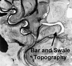
As water rounds a meander, the water swings toward the outside bank where erosion is concentrated and then spirals toward the inside banks. As the water spirals toward the inside of the meander it is slowed by frictional drag imposed by the bed of the channel. This causes deposition of alluvium on the inside bank to form a bar. A point bar forms on the inside bank of a meander and rising from the channel as an accumulation of alluvium. As the channel meander continues to erode laterally, a succession of bars with intervening swales form called bar and swale topography.
Neck & Cutoff
A neck is the upland between opposing meanders of a stream. A cutoff ![]() occurs when the neck between river meanders is eroded away and the meanders join to shorten the length of the channel. The slope of the channel increases as well when the river shortens its length.
occurs when the neck between river meanders is eroded away and the meanders join to shorten the length of the channel. The slope of the channel increases as well when the river shortens its length.
Mark Twain aptly described the process and effect of river cutoffs when he wrote:
"The Mississippi is remarkable in another way--its disposition to make prodigious jumps by cutting through narrow necks of land, and thus straightening and shortening itself. More than once it has shortened itself thirty miles at a single jump! These cut-offs have curious effects: they have thrown several river towns into the rural districts, and built up sand bars and forests in front of them. The town of Delta used to be three miles below Vicksburg: a recent cutoff has radically changed the position, and Delta is two miles above Vicksburg."
~ Life on the Mississippi ~
Oxbow lake & meander scar
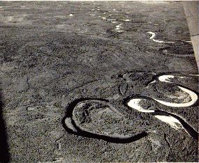
A river cut-off results in a portion of the river isolated from the new channel called an oxbow lake. ![]()
![]() Oxbow lakes are typically crescent shaped - like that of an oxbow. Groundwater seeping into the oxbow maintains the lake. Some oxbows will drain or silt up due to deposition during floods. The remnants of the oxbow is identified as a meander scar.
Oxbow lakes are typically crescent shaped - like that of an oxbow. Groundwater seeping into the oxbow maintains the lake. Some oxbows will drain or silt up due to deposition during floods. The remnants of the oxbow is identified as a meander scar. ![]() Wetland and marshes are often found in the scar.
Wetland and marshes are often found in the scar.
Video: Cut-off and Oxbow Formation on a Stream Table (Courtesy stevekny)
(A stream table is used to model and simulate stream flow.)
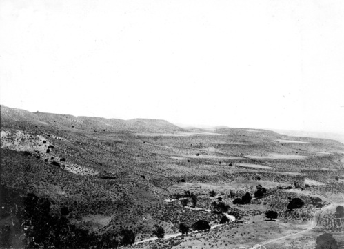
Stream terraces
Stream terraces are elevated portions of a floodplain created when the stream down cuts and creates a new floodplain at a lower elevation. Stream terraces are important indicators of environmental change. Down cutting can be initiated by uplift of the land surface due to tectonic activity, increased flow, or a loss of sediment load.
Deltas
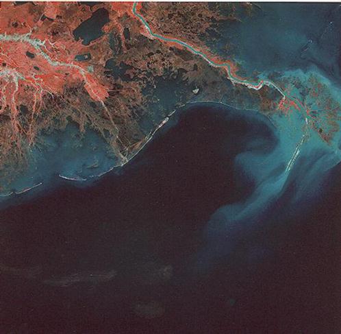
(Courtesy USGS)
Deltas form by the deposition of sediment at the mouth of stream when water flows into a lake or the ocean. Stream velocity decreases upon entering the ocean which causes the stream to deposit its load. The shape of a delta depends on a number of factors like the rate of sediment supply, wave action and coastal currents reworking the deposited sediment, and the rate at which the alluvial deposits subsides. For more about deltas see: "Deltaic Landforms" Geomorphology From Space, NASA.