
18.1: The Stream System
- Page ID
- 16639

\( \newcommand{\vecs}[1]{\overset { \scriptstyle \rightharpoonup} {\mathbf{#1}} } \)
\( \newcommand{\vecd}[1]{\overset{-\!-\!\rightharpoonup}{\vphantom{a}\smash {#1}}} \)
\( \newcommand{\dsum}{\displaystyle\sum\limits} \)
\( \newcommand{\dint}{\displaystyle\int\limits} \)
\( \newcommand{\dlim}{\displaystyle\lim\limits} \)
\( \newcommand{\id}{\mathrm{id}}\) \( \newcommand{\Span}{\mathrm{span}}\)
( \newcommand{\kernel}{\mathrm{null}\,}\) \( \newcommand{\range}{\mathrm{range}\,}\)
\( \newcommand{\RealPart}{\mathrm{Re}}\) \( \newcommand{\ImaginaryPart}{\mathrm{Im}}\)
\( \newcommand{\Argument}{\mathrm{Arg}}\) \( \newcommand{\norm}[1]{\| #1 \|}\)
\( \newcommand{\inner}[2]{\langle #1, #2 \rangle}\)
\( \newcommand{\Span}{\mathrm{span}}\)
\( \newcommand{\id}{\mathrm{id}}\)
\( \newcommand{\Span}{\mathrm{span}}\)
\( \newcommand{\kernel}{\mathrm{null}\,}\)
\( \newcommand{\range}{\mathrm{range}\,}\)
\( \newcommand{\RealPart}{\mathrm{Re}}\)
\( \newcommand{\ImaginaryPart}{\mathrm{Im}}\)
\( \newcommand{\Argument}{\mathrm{Arg}}\)
\( \newcommand{\norm}[1]{\| #1 \|}\)
\( \newcommand{\inner}[2]{\langle #1, #2 \rangle}\)
\( \newcommand{\Span}{\mathrm{span}}\) \( \newcommand{\AA}{\unicode[.8,0]{x212B}}\)
\( \newcommand{\vectorA}[1]{\vec{#1}} % arrow\)
\( \newcommand{\vectorAt}[1]{\vec{\text{#1}}} % arrow\)
\( \newcommand{\vectorB}[1]{\overset { \scriptstyle \rightharpoonup} {\mathbf{#1}} } \)
\( \newcommand{\vectorC}[1]{\textbf{#1}} \)
\( \newcommand{\vectorD}[1]{\overrightarrow{#1}} \)
\( \newcommand{\vectorDt}[1]{\overrightarrow{\text{#1}}} \)
\( \newcommand{\vectE}[1]{\overset{-\!-\!\rightharpoonup}{\vphantom{a}\smash{\mathbf {#1}}}} \)
\( \newcommand{\vecs}[1]{\overset { \scriptstyle \rightharpoonup} {\mathbf{#1}} } \)
\(\newcommand{\longvect}{\overrightarrow}\)
\( \newcommand{\vecd}[1]{\overset{-\!-\!\rightharpoonup}{\vphantom{a}\smash {#1}}} \)
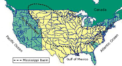
\(\newcommand{\avec}{\mathbf a}\) \(\newcommand{\bvec}{\mathbf b}\) \(\newcommand{\cvec}{\mathbf c}\) \(\newcommand{\dvec}{\mathbf d}\) \(\newcommand{\dtil}{\widetilde{\mathbf d}}\) \(\newcommand{\evec}{\mathbf e}\) \(\newcommand{\fvec}{\mathbf f}\) \(\newcommand{\nvec}{\mathbf n}\) \(\newcommand{\pvec}{\mathbf p}\) \(\newcommand{\qvec}{\mathbf q}\) \(\newcommand{\svec}{\mathbf s}\) \(\newcommand{\tvec}{\mathbf t}\) \(\newcommand{\uvec}{\mathbf u}\) \(\newcommand{\vvec}{\mathbf v}\) \(\newcommand{\wvec}{\mathbf w}\) \(\newcommand{\xvec}{\mathbf x}\) \(\newcommand{\yvec}{\mathbf y}\) \(\newcommand{\zvec}{\mathbf z}\) \(\newcommand{\rvec}{\mathbf r}\) \(\newcommand{\mvec}{\mathbf m}\) \(\newcommand{\zerovec}{\mathbf 0}\) \(\newcommand{\onevec}{\mathbf 1}\) \(\newcommand{\real}{\mathbb R}\) \(\newcommand{\twovec}[2]{\left[\begin{array}{r}#1 \\ #2 \end{array}\right]}\) \(\newcommand{\ctwovec}[2]{\left[\begin{array}{c}#1 \\ #2 \end{array}\right]}\) \(\newcommand{\threevec}[3]{\left[\begin{array}{r}#1 \\ #2 \\ #3 \end{array}\right]}\) \(\newcommand{\cthreevec}[3]{\left[\begin{array}{c}#1 \\ #2 \\ #3 \end{array}\right]}\) \(\newcommand{\fourvec}[4]{\left[\begin{array}{r}#1 \\ #2 \\ #3 \\ #4 \end{array}\right]}\) \(\newcommand{\cfourvec}[4]{\left[\begin{array}{c}#1 \\ #2 \\ #3 \\ #4 \end{array}\right]}\) \(\newcommand{\fivevec}[5]{\left[\begin{array}{r}#1 \\ #2 \\ #3 \\ #4 \\ #5 \\ \end{array}\right]}\) \(\newcommand{\cfivevec}[5]{\left[\begin{array}{c}#1 \\ #2 \\ #3 \\ #4 \\ #5 \\ \end{array}\right]}\) \(\newcommand{\mattwo}[4]{\left[\begin{array}{rr}#1 \amp #2 \\ #3 \amp #4 \\ \end{array}\right]}\) \(\newcommand{\laspan}[1]{\text{Span}\{#1\}}\) \(\newcommand{\bcal}{\cal B}\) \(\newcommand{\ccal}{\cal C}\) \(\newcommand{\scal}{\cal S}\) \(\newcommand{\wcal}{\cal W}\) \(\newcommand{\ecal}{\cal E}\) \(\newcommand{\coords}[2]{\left\{#1\right\}_{#2}}\) \(\newcommand{\gray}[1]{\color{gray}{#1}}\) \(\newcommand{\lgray}[1]{\color{lightgray}{#1}}\) \(\newcommand{\rank}{\operatorname{rank}}\) \(\newcommand{\row}{\text{Row}}\) \(\newcommand{\col}{\text{Col}}\) \(\renewcommand{\row}{\text{Row}}\) \(\newcommand{\nul}{\text{Nul}}\) \(\newcommand{\var}{\text{Var}}\) \(\newcommand{\corr}{\text{corr}}\) \(\newcommand{\len}[1]{\left|#1\right|}\) \(\newcommand{\bbar}{\overline{\bvec}}\) \(\newcommand{\bhat}{\widehat{\bvec}}\) \(\newcommand{\bperp}{\bvec^\perp}\) \(\newcommand{\xhat}{\widehat{\xvec}}\) \(\newcommand{\vhat}{\widehat{\vvec}}\) \(\newcommand{\uhat}{\widehat{\uvec}}\) \(\newcommand{\what}{\widehat{\wvec}}\) \(\newcommand{\Sighat}{\widehat{\Sigma}}\) \(\newcommand{\lt}{<}\) \(\newcommand{\gt}{>}\) \(\newcommand{\amp}{&}\) \(\definecolor{fillinmathshade}{gray}{0.9}\)The fundamental unit of study for fluvial processes is the drainage basin or watershed. A drainage basin is a portion of the Earth's surface that contains a main stream and its tributaries and is bounded by a drainage divide. The drainage divide represents the boundary between adjacent drainage basins and determines into which basin precipitation flows. There is no upper or lower limit to the size of a drainage basin. We can delimit the drainage basin of the Mississippi River as most of the area east of the Rocky Mountains. The main stream is the Mississippi River and its tributaries are rivers like the Missouri, Arkansas, and Wisconsin to name just a few. Or, at a more local scale we can delimit the Wolf River basin found in central Wisconsin.
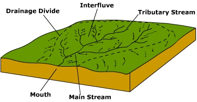
Streams within the drainage basin are either perennial or intermittent in flow. Perennial streams flow all year. The base flow of these streams is provided by groundwater seepage into the channel. Tributary streams are small streams that enter into the main stream. Tributary streams, especially the smaller ones around the periphery of the basin, are intermittent. Intermittent streams ![]() only flow during wetter times of the year. Much of their flow is provided by surface runoff and when the water table is higher as a result of moist conditions. The upland between tributaries is called an interfluve.
only flow during wetter times of the year. Much of their flow is provided by surface runoff and when the water table is higher as a result of moist conditions. The upland between tributaries is called an interfluve.
The famous geographer John Wesley Powell recognized the value of the watershed concept in environmental planning. In 1878 Powell published his Report on the Lands of the Arid Region, which propose a strategy for settling the western United States without fighting over limited water resources. All Things Considered's Howard Berkes reports "Powell's knowledge of the region convinced him that water, or the lack of it, would be a major and ongoing problem in America's westward expansion." ► Powell proposed to organize settlements around water and watersheds because overuse or pollution would impact everyone in the watershed.
Some streams are classified as exotic streams. Exotic streams are those that originate in a humid region but flow through an arid region. Such is the case of the Nile and Colorado Rivers. The headwaters of the Nile River is in the wet Ethiopian Highlands, and travels through the eastern portion of the Sahara Desert on its way to the Mediterranean Sea. Along its route, the river loses substantial amounts of water to evaporation. The same is true for the Colorado River. With its headwaters in the Rocky Mountains, it flows south and west towards the southwest desert of the United States. During its journey it loses nearly half its flow to evaporation. The Colorado used to flow to the ocean, astonishingly it no longer does. The reason is that the remaining water has been diverted for agriculture and municipal water use.
Drainage Patterns
Over time, a stream system achieves a particular drainage pattern to its network of stream channels and tributaries as determined by local geologic factors. Drainage patterns or nets are classified on the basis of their form and texture. Their shape or pattern develops in response to the local topography and subsurface geology. Drainage channels develop where surface runoff is enhanced and earth materials provide the least resistance to erosion. The texture is governed by soil infiltration, and the volume of water available in a given period of time to enter the surface. If the soil has only a moderate infiltration capacity and a small amount of precipitation strikes the surface over a given period of time, the water will likely soak in rather than evaporate away. If a large amount of water strikes the surface then more water will evaporate, soaks into the surface, or ponds on level ground. On sloping surfaces this excess water will runoff. Fewer drainage channels will develop where the surface is flat and the soil infiltration is high because the water will soak into the surface. The fewer number of channels, the coarser will be the drainage pattern.
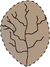
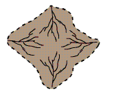
A dendritic drainage pattern is the most common form and looks like the branching pattern of tree roots. It develops in regions underlain by homogeneous material. That is, the subsurface geology has a similar resistance to weathering so there is no apparent control over the direction the tributaries take. Tributaries joining larger streams at acute angle (less than 90 degrees). ![]()
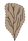
Parallel drainage patterns form where there is a pronounced slope to the surface. A parallel pattern also develops in regions of parallel, elongate landforms like outcropping resistant rock bands. Tributary streams tend to stretch out in a parallel-like fashion following the slope of the surface. A parallel pattern sometimes indicates the presence of a major fault that cuts across an area of steeply folded bedrock. All forms of transitions can occur between parallel, dendritic, and trellis patterns. ![]()
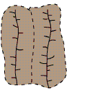
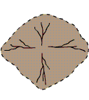
Trellis drainage patterns look similar to their namesake, the common garden trellis. Trellis drainage develops in folded topography like that found in the Appalachian Mountains of North America. Down-turned folds called synclines form valleys in which resides the main channel of the stream. Short tributary streams enter the main channel at sharp angles as they run down sides of parallel ridges called anticlines. Tributaries join the main stream at nearly right angles. ![]()
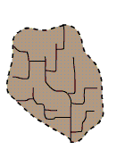
The rectangular drainage pattern is found in regions that have undergone faulting. Streams follow the path of least resistance and thus are concentrated in places were exposed rock is the weakest. Movement of the surface due to faulting off-sets the direction of the stream. As a result, the tributary streams make sharp bends and enter the main stream at high angles.
View an offset stream along the San Andreas Fault in Google Earth.
The radial drainage pattern develops around a central elevated point. This pattern is common to such conically shaped features as volcanoes. The tributary streams extend the headward reaches upslope toward the top of the volcano. ![]()
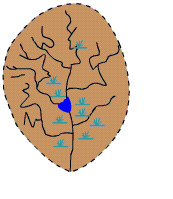
The centripetal drainage pattern is just the opposite of the radial as streams flow toward a central depression. This pattern is typical in the western and southwestern portions of the United States where basins exhibit interior drainage. During wetter portions of the year, these streams feed ephemeral lakes, which evaporate away during dry periods. Salt flats are created in these dry lake beds as salt dissolved in the lake water precipitates out of solution and is left behind when the water evaporates away.
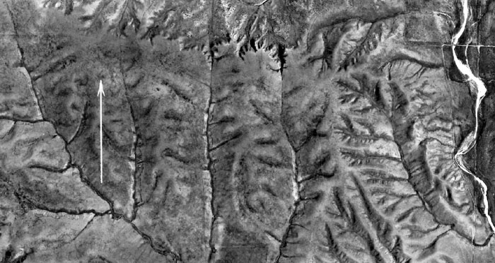
Deranged or contorted patterns develop from the disruption of a pre-existing drainage pattern. Figure \(\PageIndex{11}\) began as a dendritic pattern but was altered when overrun by glacier. After receding, the glacier left behind fine grain material that form wetlands and deposits that dammed the stream to impound a small lake. The tributary streams appear significantly more contorted than they were prior to glaciation. ![]()
The patterns described above are accordant, or correlated with the structure and relief over which they flow. Those streams that are discordant with the rocks over which they flow are either antecedent or superimposed. For instance, antecedent streams flowed across bedrock structures prior to uplift. Slow mountain building permitted stream erosion to keep pace with uplift. Such appears to be the case for the Columbia River that cuts across the Cascade Mountains. Streams in portions of the Appalachian Mountains have formed in weaker rock that through time has eroded away. These streams appear to be superimposed over the rock layers that they presently flow over. The Cumberland Gap is a famous water gap formed in this way as it cuts through the folds of the Appalachians.