
15.2: Plate Boundaries
- Page ID
- 16487

\( \newcommand{\vecs}[1]{\overset { \scriptstyle \rightharpoonup} {\mathbf{#1}} } \)
\( \newcommand{\vecd}[1]{\overset{-\!-\!\rightharpoonup}{\vphantom{a}\smash {#1}}} \)
\( \newcommand{\dsum}{\displaystyle\sum\limits} \)
\( \newcommand{\dint}{\displaystyle\int\limits} \)
\( \newcommand{\dlim}{\displaystyle\lim\limits} \)
\( \newcommand{\id}{\mathrm{id}}\) \( \newcommand{\Span}{\mathrm{span}}\)
( \newcommand{\kernel}{\mathrm{null}\,}\) \( \newcommand{\range}{\mathrm{range}\,}\)
\( \newcommand{\RealPart}{\mathrm{Re}}\) \( \newcommand{\ImaginaryPart}{\mathrm{Im}}\)
\( \newcommand{\Argument}{\mathrm{Arg}}\) \( \newcommand{\norm}[1]{\| #1 \|}\)
\( \newcommand{\inner}[2]{\langle #1, #2 \rangle}\)
\( \newcommand{\Span}{\mathrm{span}}\)
\( \newcommand{\id}{\mathrm{id}}\)
\( \newcommand{\Span}{\mathrm{span}}\)
\( \newcommand{\kernel}{\mathrm{null}\,}\)
\( \newcommand{\range}{\mathrm{range}\,}\)
\( \newcommand{\RealPart}{\mathrm{Re}}\)
\( \newcommand{\ImaginaryPart}{\mathrm{Im}}\)
\( \newcommand{\Argument}{\mathrm{Arg}}\)
\( \newcommand{\norm}[1]{\| #1 \|}\)
\( \newcommand{\inner}[2]{\langle #1, #2 \rangle}\)
\( \newcommand{\Span}{\mathrm{span}}\) \( \newcommand{\AA}{\unicode[.8,0]{x212B}}\)
\( \newcommand{\vectorA}[1]{\vec{#1}} % arrow\)
\( \newcommand{\vectorAt}[1]{\vec{\text{#1}}} % arrow\)
\( \newcommand{\vectorB}[1]{\overset { \scriptstyle \rightharpoonup} {\mathbf{#1}} } \)
\( \newcommand{\vectorC}[1]{\textbf{#1}} \)
\( \newcommand{\vectorD}[1]{\overrightarrow{#1}} \)
\( \newcommand{\vectorDt}[1]{\overrightarrow{\text{#1}}} \)
\( \newcommand{\vectE}[1]{\overset{-\!-\!\rightharpoonup}{\vphantom{a}\smash{\mathbf {#1}}}} \)
\( \newcommand{\vecs}[1]{\overset { \scriptstyle \rightharpoonup} {\mathbf{#1}} } \)
\(\newcommand{\longvect}{\overrightarrow}\)
\( \newcommand{\vecd}[1]{\overset{-\!-\!\rightharpoonup}{\vphantom{a}\smash {#1}}} \)
\(\newcommand{\avec}{\mathbf a}\) \(\newcommand{\bvec}{\mathbf b}\) \(\newcommand{\cvec}{\mathbf c}\) \(\newcommand{\dvec}{\mathbf d}\) \(\newcommand{\dtil}{\widetilde{\mathbf d}}\) \(\newcommand{\evec}{\mathbf e}\) \(\newcommand{\fvec}{\mathbf f}\) \(\newcommand{\nvec}{\mathbf n}\) \(\newcommand{\pvec}{\mathbf p}\) \(\newcommand{\qvec}{\mathbf q}\) \(\newcommand{\svec}{\mathbf s}\) \(\newcommand{\tvec}{\mathbf t}\) \(\newcommand{\uvec}{\mathbf u}\) \(\newcommand{\vvec}{\mathbf v}\) \(\newcommand{\wvec}{\mathbf w}\) \(\newcommand{\xvec}{\mathbf x}\) \(\newcommand{\yvec}{\mathbf y}\) \(\newcommand{\zvec}{\mathbf z}\) \(\newcommand{\rvec}{\mathbf r}\) \(\newcommand{\mvec}{\mathbf m}\) \(\newcommand{\zerovec}{\mathbf 0}\) \(\newcommand{\onevec}{\mathbf 1}\) \(\newcommand{\real}{\mathbb R}\) \(\newcommand{\twovec}[2]{\left[\begin{array}{r}#1 \\ #2 \end{array}\right]}\) \(\newcommand{\ctwovec}[2]{\left[\begin{array}{c}#1 \\ #2 \end{array}\right]}\) \(\newcommand{\threevec}[3]{\left[\begin{array}{r}#1 \\ #2 \\ #3 \end{array}\right]}\) \(\newcommand{\cthreevec}[3]{\left[\begin{array}{c}#1 \\ #2 \\ #3 \end{array}\right]}\) \(\newcommand{\fourvec}[4]{\left[\begin{array}{r}#1 \\ #2 \\ #3 \\ #4 \end{array}\right]}\) \(\newcommand{\cfourvec}[4]{\left[\begin{array}{c}#1 \\ #2 \\ #3 \\ #4 \end{array}\right]}\) \(\newcommand{\fivevec}[5]{\left[\begin{array}{r}#1 \\ #2 \\ #3 \\ #4 \\ #5 \\ \end{array}\right]}\) \(\newcommand{\cfivevec}[5]{\left[\begin{array}{c}#1 \\ #2 \\ #3 \\ #4 \\ #5 \\ \end{array}\right]}\) \(\newcommand{\mattwo}[4]{\left[\begin{array}{rr}#1 \amp #2 \\ #3 \amp #4 \\ \end{array}\right]}\) \(\newcommand{\laspan}[1]{\text{Span}\{#1\}}\) \(\newcommand{\bcal}{\cal B}\) \(\newcommand{\ccal}{\cal C}\) \(\newcommand{\scal}{\cal S}\) \(\newcommand{\wcal}{\cal W}\) \(\newcommand{\ecal}{\cal E}\) \(\newcommand{\coords}[2]{\left\{#1\right\}_{#2}}\) \(\newcommand{\gray}[1]{\color{gray}{#1}}\) \(\newcommand{\lgray}[1]{\color{lightgray}{#1}}\) \(\newcommand{\rank}{\operatorname{rank}}\) \(\newcommand{\row}{\text{Row}}\) \(\newcommand{\col}{\text{Col}}\) \(\renewcommand{\row}{\text{Row}}\) \(\newcommand{\nul}{\text{Nul}}\) \(\newcommand{\var}{\text{Var}}\) \(\newcommand{\corr}{\text{corr}}\) \(\newcommand{\len}[1]{\left|#1\right|}\) \(\newcommand{\bbar}{\overline{\bvec}}\) \(\newcommand{\bhat}{\widehat{\bvec}}\) \(\newcommand{\bperp}{\bvec^\perp}\) \(\newcommand{\xhat}{\widehat{\xvec}}\) \(\newcommand{\vhat}{\widehat{\vvec}}\) \(\newcommand{\uhat}{\widehat{\uvec}}\) \(\newcommand{\what}{\widehat{\wvec}}\) \(\newcommand{\Sighat}{\widehat{\Sigma}}\) \(\newcommand{\lt}{<}\) \(\newcommand{\gt}{>}\) \(\newcommand{\amp}{&}\) \(\definecolor{fillinmathshade}{gray}{0.9}\)Along the boundary of the Earth's tectonic plates a fiery drama of catastrophic proportions is played out. Movement of the Earth's crust creates earthquake activity and in some places great outpourings of lava extrude onto the surface.
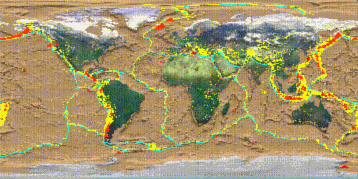
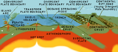
Four types of plate boundaries are recognized and are depicted in Figure \(\PageIndex{1}\) A spreading or divergent boundary occurs where plates are moving away (diverging) from one another, like that occuring along the midocean ridge where new crust is formed  . Convergent boundaries are located where subduction is active and the lithosphere is being "consumed". This occurs where two plates collide with one another. Transform boundaries occur where plates are grinding past one another, like the San Andreas fault. Plate boundary zones are broad belts in which boundaries are not well defined and the effects of plate interaction are unclear. Understanding plate motions (USGS) is important in deciphering land forming processes that occur along plate boundaries.
Video: Plate tectonics: Geological features of divergent plate boundaries (Courtesy Khan Academy)
Video: Plate tectonics: Geological features of convergent plate boundaries (Courtesy Khan Academy)
Plate Boundaries and Earthquakes
An earthquake is the shaking of the Earth as a result of crustal movement. Earthquakes emanate from faults, or fractures in the Earth where movement occurs. Most earthquakes occur at the boundaries where plates meet. Submarine earthquakes create seismic ocean waves that travel long distances across the ocean. They often strike land with devastating consequences. [For an animation of how earthquakes are propagated see "The Savage Earth" - The Restless Planet: Earthquakes animation , NOVA, PBS].The location of earthquakes and the ruptures associated with them are what scientists use to define plate edges.
There are several different kinds of faults classified according to the type of movement that occurs. Where plates move horizontally past one another, transform faults occur. Such is the case of the San Andreas Fault in California. Where the crust is spreading apart, like the mid-ocean ridge, shallow earthquakes (within 30 kilometers of the surface) are common. Shallow to deep earthquakes occur along subduction zones where one plate overrides another, like that which occurs along the northwest coast of the United States, western Canada and southern Alaska.
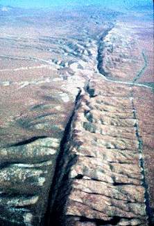
Plate Boundaries and Volcanoes
Looking at a map of lithospheric plate boundaries shows volcanic activity along the boundaries of some lithospheric plates. Convergent plate boundaries where subduction occurs commonly experience volcanic activity . The "Ring of Fire" that extends from the west coast of the United States toward the Aleutian Islands and over to Japan is a good example of volcano activity associated with the margins of plates. Mt. St. Helens (Washington), Mt. Shishaldin (Alaska), and Mt. Fujiyama (Japan) were born from the collision and associated melting of plates beneath the surface of the Earth. These "stratovolcanoes" are built by enormous eruptions of viscous lava and ash created from magma rich in silica.

Volcanoes are also found along spreading plate boundaries. Here, basaltic magma is extruded onto the floor of the ocean. In some places, the magma solidifies into great volcanic cones rising from the ocean floor. Iceland's Heimaey volcano is a good example of volcanic activity along the midocean ridge.
One of the most well-known locations for volcanic activity, the Hawaiian Islands, is not a product of plate margin processes. The Hawaiian Islands have formed over a "hot spot" or mantle plume where magma rises to the surface and flows out onto the ocean floor. The chain of islands were created as the Pacific Plate moves over the mantle plume creating a succession of volcanoes oriented in a northwest (oldest) to southeast direction (youngest).