
8.4: Wave Cyclones (Cyclogenesis)
- Page ID
- 16066

\( \newcommand{\vecs}[1]{\overset { \scriptstyle \rightharpoonup} {\mathbf{#1}} } \)
\( \newcommand{\vecd}[1]{\overset{-\!-\!\rightharpoonup}{\vphantom{a}\smash {#1}}} \)
\( \newcommand{\dsum}{\displaystyle\sum\limits} \)
\( \newcommand{\dint}{\displaystyle\int\limits} \)
\( \newcommand{\dlim}{\displaystyle\lim\limits} \)
\( \newcommand{\id}{\mathrm{id}}\) \( \newcommand{\Span}{\mathrm{span}}\)
( \newcommand{\kernel}{\mathrm{null}\,}\) \( \newcommand{\range}{\mathrm{range}\,}\)
\( \newcommand{\RealPart}{\mathrm{Re}}\) \( \newcommand{\ImaginaryPart}{\mathrm{Im}}\)
\( \newcommand{\Argument}{\mathrm{Arg}}\) \( \newcommand{\norm}[1]{\| #1 \|}\)
\( \newcommand{\inner}[2]{\langle #1, #2 \rangle}\)
\( \newcommand{\Span}{\mathrm{span}}\)
\( \newcommand{\id}{\mathrm{id}}\)
\( \newcommand{\Span}{\mathrm{span}}\)
\( \newcommand{\kernel}{\mathrm{null}\,}\)
\( \newcommand{\range}{\mathrm{range}\,}\)
\( \newcommand{\RealPart}{\mathrm{Re}}\)
\( \newcommand{\ImaginaryPart}{\mathrm{Im}}\)
\( \newcommand{\Argument}{\mathrm{Arg}}\)
\( \newcommand{\norm}[1]{\| #1 \|}\)
\( \newcommand{\inner}[2]{\langle #1, #2 \rangle}\)
\( \newcommand{\Span}{\mathrm{span}}\) \( \newcommand{\AA}{\unicode[.8,0]{x212B}}\)
\( \newcommand{\vectorA}[1]{\vec{#1}} % arrow\)
\( \newcommand{\vectorAt}[1]{\vec{\text{#1}}} % arrow\)
\( \newcommand{\vectorB}[1]{\overset { \scriptstyle \rightharpoonup} {\mathbf{#1}} } \)
\( \newcommand{\vectorC}[1]{\textbf{#1}} \)
\( \newcommand{\vectorD}[1]{\overrightarrow{#1}} \)
\( \newcommand{\vectorDt}[1]{\overrightarrow{\text{#1}}} \)
\( \newcommand{\vectE}[1]{\overset{-\!-\!\rightharpoonup}{\vphantom{a}\smash{\mathbf {#1}}}} \)
\( \newcommand{\vecs}[1]{\overset { \scriptstyle \rightharpoonup} {\mathbf{#1}} } \)
\(\newcommand{\longvect}{\overrightarrow}\)
\( \newcommand{\vecd}[1]{\overset{-\!-\!\rightharpoonup}{\vphantom{a}\smash {#1}}} \)
\(\newcommand{\avec}{\mathbf a}\) \(\newcommand{\bvec}{\mathbf b}\) \(\newcommand{\cvec}{\mathbf c}\) \(\newcommand{\dvec}{\mathbf d}\) \(\newcommand{\dtil}{\widetilde{\mathbf d}}\) \(\newcommand{\evec}{\mathbf e}\) \(\newcommand{\fvec}{\mathbf f}\) \(\newcommand{\nvec}{\mathbf n}\) \(\newcommand{\pvec}{\mathbf p}\) \(\newcommand{\qvec}{\mathbf q}\) \(\newcommand{\svec}{\mathbf s}\) \(\newcommand{\tvec}{\mathbf t}\) \(\newcommand{\uvec}{\mathbf u}\) \(\newcommand{\vvec}{\mathbf v}\) \(\newcommand{\wvec}{\mathbf w}\) \(\newcommand{\xvec}{\mathbf x}\) \(\newcommand{\yvec}{\mathbf y}\) \(\newcommand{\zvec}{\mathbf z}\) \(\newcommand{\rvec}{\mathbf r}\) \(\newcommand{\mvec}{\mathbf m}\) \(\newcommand{\zerovec}{\mathbf 0}\) \(\newcommand{\onevec}{\mathbf 1}\) \(\newcommand{\real}{\mathbb R}\) \(\newcommand{\twovec}[2]{\left[\begin{array}{r}#1 \\ #2 \end{array}\right]}\) \(\newcommand{\ctwovec}[2]{\left[\begin{array}{c}#1 \\ #2 \end{array}\right]}\) \(\newcommand{\threevec}[3]{\left[\begin{array}{r}#1 \\ #2 \\ #3 \end{array}\right]}\) \(\newcommand{\cthreevec}[3]{\left[\begin{array}{c}#1 \\ #2 \\ #3 \end{array}\right]}\) \(\newcommand{\fourvec}[4]{\left[\begin{array}{r}#1 \\ #2 \\ #3 \\ #4 \end{array}\right]}\) \(\newcommand{\cfourvec}[4]{\left[\begin{array}{c}#1 \\ #2 \\ #3 \\ #4 \end{array}\right]}\) \(\newcommand{\fivevec}[5]{\left[\begin{array}{r}#1 \\ #2 \\ #3 \\ #4 \\ #5 \\ \end{array}\right]}\) \(\newcommand{\cfivevec}[5]{\left[\begin{array}{c}#1 \\ #2 \\ #3 \\ #4 \\ #5 \\ \end{array}\right]}\) \(\newcommand{\mattwo}[4]{\left[\begin{array}{rr}#1 \amp #2 \\ #3 \amp #4 \\ \end{array}\right]}\) \(\newcommand{\laspan}[1]{\text{Span}\{#1\}}\) \(\newcommand{\bcal}{\cal B}\) \(\newcommand{\ccal}{\cal C}\) \(\newcommand{\scal}{\cal S}\) \(\newcommand{\wcal}{\cal W}\) \(\newcommand{\ecal}{\cal E}\) \(\newcommand{\coords}[2]{\left\{#1\right\}_{#2}}\) \(\newcommand{\gray}[1]{\color{gray}{#1}}\) \(\newcommand{\lgray}[1]{\color{lightgray}{#1}}\) \(\newcommand{\rank}{\operatorname{rank}}\) \(\newcommand{\row}{\text{Row}}\) \(\newcommand{\col}{\text{Col}}\) \(\renewcommand{\row}{\text{Row}}\) \(\newcommand{\nul}{\text{Nul}}\) \(\newcommand{\var}{\text{Var}}\) \(\newcommand{\corr}{\text{corr}}\) \(\newcommand{\len}[1]{\left|#1\right|}\) \(\newcommand{\bbar}{\overline{\bvec}}\) \(\newcommand{\bhat}{\widehat{\bvec}}\) \(\newcommand{\bperp}{\bvec^\perp}\) \(\newcommand{\xhat}{\widehat{\xvec}}\) \(\newcommand{\vhat}{\widehat{\vvec}}\) \(\newcommand{\uhat}{\widehat{\uvec}}\) \(\newcommand{\what}{\widehat{\wvec}}\) \(\newcommand{\Sighat}{\widehat{\Sigma}}\) \(\newcommand{\lt}{<}\) \(\newcommand{\gt}{>}\) \(\newcommand{\amp}{&}\) \(\definecolor{fillinmathshade}{gray}{0.9}\)The variable nature of weather in the midlatitudes is in part due to the presence of midlatitude or extratropical cyclones. Appropriately called "wave cyclones", these systems take the form of an ocean wave when fully developed. Wave cyclones can grow to vast proportions, nearly 1000 miles (1600 km) wide. These vast areas of low pressure are born along the polar front where cold polar air from the north collides with warm tropical air to the south. In so doing, huge spiraling storms move across the surface guided by the polar front jet stream.
Initial Stage - Cyclogenesis
Wave cyclones form where surface convergence predominates. Cyclones often develop in the region of the Aleutian and Icelandic sub-polar low pressure cells. Wave cyclones also develop and intensify on the east slope of the Rocky Mountains, the Gulf Coast and east coasts of North America and Asia.
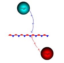
Especially during the spring and summer in the midlatitudes of North America, high pressure to the north pushes cold polar air southward from Canada. To the south, maritime tropical air streams northward toward the polar air (Figure \(\PageIndex{1}\)).The polar front is depicted by the symbols for a stationary front (the alternating red semi-circle and blue triangles). At the location where the opposing streams of air meet, cyclonic shear is created from opposing air streams sliding by each other causing the air to spin. You can demonstrate what happens as a result of cyclonic shear by placing a pencil between your hands. Push your right hand away from you (warm southerly flow) and draw your left hand towards you (cold, northerly flow). (Go ahead and try this to see if I'm right.) Examine what happens to the pencil. If you followed directions the pencil should be rotating in a counterclockwise fashion. Click here for more information about the initial stage of cyclone development.
Mature Stage
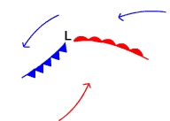
Once the air collides and cyclonic circulation commences, warm air from the south invades where cold air was once located north of the polar front (Figure \(\PageIndex{2}\)). A warm front develops where warm air replaces the cold air. The position of a warm front on a weather map is depicted (in red) with a line showing the boundary between the air masses and semi-circles indicating the direction the front is moving. To the west of the center of the developing system, cold air is sliding south replacing warm air at the surface. A cold front (blue triangles) develops where cold air replaces the warm air. Soon the developing system takes on the characteristic wave form, hence their name "wave cyclone". The lowest pressure is found at the center or apex of the wave.
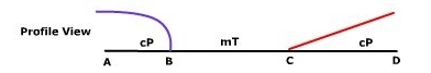
Figure \(\PageIndex{3}\) depicts the profile view of the open wave along a cross section just to the south of the system center. The less dense warmer air slides up and over the colder more dense air. Surface friction imposed by the ground slows the advance of the front compared to its position aloft yielding a gentle slope to the front.
Occluded Stage
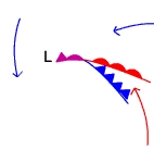
Being more dense, the air behind the cold front can "bulldoze" the warmer and less dense air out of the way. The advancing warm air along the warm front cannot push the colder air in its path out of the way. Instead, the warm air rises off the surface and glides up and over the colder more dense air ahead of the warm front. As a result, there is less horizontal displacement and the warm front moves slower across the earth than does a cold front. Over time the cold front catches up with the warm front and the cyclone starts to occlude (purple symbol on Figure \(\PageIndex{4}\)). Click here to see the life-cycle of a wave cyclone from the initial (cyclogenesis) to occluded stage. Link here to an animated profile view of the occlusion process.
Dissolving Stage
The system enters the dissolving stage after it occludes and the lifting mechanism is cutoff. Without the convergence and uplift, the cyclone dissipates in the atmosphere.
Surface Cyclones and the Jet Stream
Above the polar front lies the polar front jet stream, a zone of faster moving air in the upper troposphere. The jet stream takes on a meandering pattern with regions of faster and slower air. Within the jet stream there are regions air convergence and divergence.
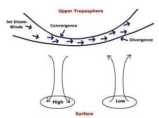
Recall that surface air converges and rises in low pressure systems. To maintain low pressure at the surface the rising air must diverge at the top. It is this upper air divergence in the jet stream that "pulls" air upward to help form surface cyclones. In so doing, surface cyclones tend to follow the path of the jet stream. Figure \(\PageIndex{5}\) shows the relationship between upper-level flow and surface pressure systems. We can see that where upper level convergence occurs air sinks to promote high pressure at the surface. Where upper-level divergence occurs air is pulled up from the surface to help create low pressure near the ground. Wave cyclones dissolve when they no longer have the upper level divergence to maintain them.