
8.5: Weather and Wave Cyclones
- Page ID
- 16069

The weather associated with the passage of a wave cyclone is a product of the convergence and frontal uplift found in the system. The wave cyclone can be divided into three sectors: (1) the cool sector ahead of the warm front, (2) the warm sector between the cold and warm fronts, and (3) the cold sector located behind the cold front (Figure \(\PageIndex{1}\)).
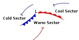
During the spring, summer, and fall, cP air masses tend to occupy the cold and cool sectors while an mT air mass lies in the warm sector. The cold sector generally has the lowest temperatures as cold air is coming from a northerly direction. Air in the cool sector is coming from an easterly direction so it is warmer than the air in the cold sector. In the warm sector air is entering the system from the south so we should expect to find the warmest temperatures in this region. In the next few sections we'll examine the weather associated with the various sectors and fronts.
Weather patterns
Figure \(\PageIndex{2}\) illustrates two views of a wave cyclone, the top portion is a weather map view looking down on the system from above. The bottom portion shows a simple profile (side) view along the line identified as the "Profile Transect" that connects points A, B, C, D on the weather map view.
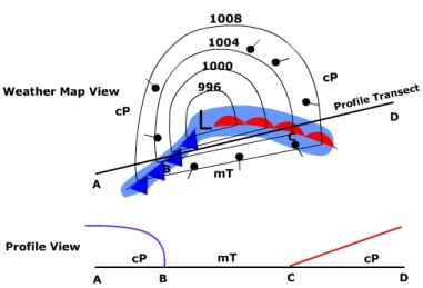
Let's examine the weather map view first. Isobars have been constructed to show the distribution of pressure around the cyclone. Notice that the lowest pressure is at the center of the system and increases outward. Another thing to note about the isobars is the V-shape where they cross the fronts. This indicates that the front sits in a trough of lower pressure. As a front approaches you will experience a drop in atmospheric pressure. Once a front has passed the pressure will increase.
The flow of air around the system is indicated by the wind direction symbols (black dots with a line pointing in the direction of the wind). The symbols show the characteristic counterclockwise flow around a center of low pressure in the Northern Hemisphere. Ahead of the warm front, in the cool sector, the air is from an easterly direction. In the warm sector, mT air streams out of the south. Behind the cold front air comes from a westerly to northwesterly direction. The light blue area shows the distribution of precipitation. Notice there is a larger band of rain along the warm front than along the cold front.
Warm Front Weather
Figure \(\PageIndex{3}\) shows the profile view of a warm front and its associated weather. The warm front slopes gently up into the troposphere that has a direct bearing on the kinds of clouds that are produced. As the warm air behind the front collides with the cooler air ahead, the warmer less dense air is forced to glide upward.
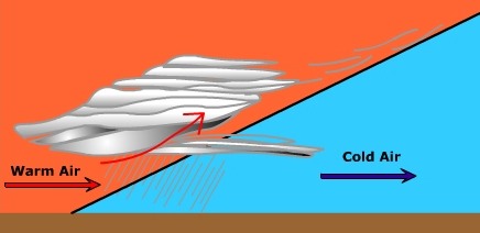
A typical sequence of clouds develops as a result of this gentle uplift. The first clouds you see as a warm front approaches are the thin, wispy cirrus clouds. As the front approaches the clouds become thicker and the cloud base lowers. As the cirrus clouds pass by you, cirrostratus and then altostratus clouds approach. As the warm front is nearly at your location you will see the clouds completely cover the sky as stratus clouds. Nimbostratus clouds along the front create low intensity precipitation that might last for a long time. Ahead of the front the wind is generally cool and from a easterly direction. As the front passes by you the wind direction shifts toward the southeast and the south. As it does the temperatures start to rise as warm air replaces the cool air at your location.
Warm Sector Weather
Once the warm front passes your location you'll notice an increase in temperature and air pressure. Soon the stratus clouds of the warm front give way to broken and clearing skies. As the warm sector moves into your location you will notice an increase in the humidity of the air. The wind is out of the south so maritime tropical air begins to invade. During the afternoon you might see an occasional puffy cumulus cloud. These "fair weather" clouds are often created by convection and instability in the warm and humid afternoon air.

After a while the winds start to shift to the southwest and the humidity continues to rise. You notice the clouds begin to grow in height, merge into larger darker masses. This indicates the air is becoming much more unstable. Once again the air pressure starts to fall. Winds begin to gust and growing cumulus clouds can be seen on the horizon. It would appear that a cold front is approaching.
Cold Front Weather
Weather along an advancing cold front is much different than that along a warm front (Figure \(\PageIndex{5}\)). Friction slows the advancing cold air causing a steep slope to the front. The steep slope pushes the air ahead of it rapidly upwards and vertically developed clouds (cumulus) are produced along the front. As with a warm front, you experience a drop in the atmospheric pressure as the front approaches. As the cold front passes you, the winds shift from south to southwest, and finally to a westerly direction.
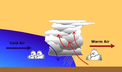

With greatly contrasting air masses on either side of the front and potentially unstable conditions, violent weather can form. Towering cumulonimbus clouds are common along cold fronts producing intense downpours of rain lasting for a relatively short period of time. Tornadoes can form under the most extreme conditions ahead of an advancing cold front.
Below is a table that briefly summarizes the weather conditions associated with wave cyclones and their associated fronts. Instead of reading from left to right, read the table from right to left. Doing so will give you the perspective of the system moving through your location with its center to the north along the transect identified in Figure \(\PageIndex{2}\). Click on the cloud abbreviations to get information about them.
|
Weather Element |
Cold Sector |
 |
Warm Sector |
 |
Cool Sector |
|---|---|---|---|---|---|
|
Air Mass |
cP |
mT |
cP |
||
|
Pressure Tendency |
rising |
falling -- rising |
falling |
||
|
Wind Direction |
NW - W |
SW - S - SE |
SE -- E |
||
|
Clouds |
Clring - Cu |
Cb - Cu - Clring |
Ns - St - As - Cs - Ci |
||
|
Precipitation |
Intense but short duration at cold front |
Light but long duration at warm front |
Cloud abbreviations:
- Ci - Cirrus
- Cs - Cirrostratus
- As - Altostratus
- St - Stratus
- Ns - Nimbostratus
- Clring - Clearing
- Cu - Cumulus
- Cb - Cumulonimbus