1.6: Future Geographies
- Page ID
- 15345
\( \newcommand{\vecs}[1]{\overset { \scriptstyle \rightharpoonup} {\mathbf{#1}} } \)
\( \newcommand{\vecd}[1]{\overset{-\!-\!\rightharpoonup}{\vphantom{a}\smash {#1}}} \)
\( \newcommand{\dsum}{\displaystyle\sum\limits} \)
\( \newcommand{\dint}{\displaystyle\int\limits} \)
\( \newcommand{\dlim}{\displaystyle\lim\limits} \)
\( \newcommand{\id}{\mathrm{id}}\) \( \newcommand{\Span}{\mathrm{span}}\)
( \newcommand{\kernel}{\mathrm{null}\,}\) \( \newcommand{\range}{\mathrm{range}\,}\)
\( \newcommand{\RealPart}{\mathrm{Re}}\) \( \newcommand{\ImaginaryPart}{\mathrm{Im}}\)
\( \newcommand{\Argument}{\mathrm{Arg}}\) \( \newcommand{\norm}[1]{\| #1 \|}\)
\( \newcommand{\inner}[2]{\langle #1, #2 \rangle}\)
\( \newcommand{\Span}{\mathrm{span}}\)
\( \newcommand{\id}{\mathrm{id}}\)
\( \newcommand{\Span}{\mathrm{span}}\)
\( \newcommand{\kernel}{\mathrm{null}\,}\)
\( \newcommand{\range}{\mathrm{range}\,}\)
\( \newcommand{\RealPart}{\mathrm{Re}}\)
\( \newcommand{\ImaginaryPart}{\mathrm{Im}}\)
\( \newcommand{\Argument}{\mathrm{Arg}}\)
\( \newcommand{\norm}[1]{\| #1 \|}\)
\( \newcommand{\inner}[2]{\langle #1, #2 \rangle}\)
\( \newcommand{\Span}{\mathrm{span}}\) \( \newcommand{\AA}{\unicode[.8,0]{x212B}}\)
\( \newcommand{\vectorA}[1]{\vec{#1}} % arrow\)
\( \newcommand{\vectorAt}[1]{\vec{\text{#1}}} % arrow\)
\( \newcommand{\vectorB}[1]{\overset { \scriptstyle \rightharpoonup} {\mathbf{#1}} } \)
\( \newcommand{\vectorC}[1]{\textbf{#1}} \)
\( \newcommand{\vectorD}[1]{\overrightarrow{#1}} \)
\( \newcommand{\vectorDt}[1]{\overrightarrow{\text{#1}}} \)
\( \newcommand{\vectE}[1]{\overset{-\!-\!\rightharpoonup}{\vphantom{a}\smash{\mathbf {#1}}}} \)
\( \newcommand{\vecs}[1]{\overset { \scriptstyle \rightharpoonup} {\mathbf{#1}} } \)
\(\newcommand{\longvect}{\overrightarrow}\)
\( \newcommand{\vecd}[1]{\overset{-\!-\!\rightharpoonup}{\vphantom{a}\smash {#1}}} \)
\(\newcommand{\avec}{\mathbf a}\) \(\newcommand{\bvec}{\mathbf b}\) \(\newcommand{\cvec}{\mathbf c}\) \(\newcommand{\dvec}{\mathbf d}\) \(\newcommand{\dtil}{\widetilde{\mathbf d}}\) \(\newcommand{\evec}{\mathbf e}\) \(\newcommand{\fvec}{\mathbf f}\) \(\newcommand{\nvec}{\mathbf n}\) \(\newcommand{\pvec}{\mathbf p}\) \(\newcommand{\qvec}{\mathbf q}\) \(\newcommand{\svec}{\mathbf s}\) \(\newcommand{\tvec}{\mathbf t}\) \(\newcommand{\uvec}{\mathbf u}\) \(\newcommand{\vvec}{\mathbf v}\) \(\newcommand{\wvec}{\mathbf w}\) \(\newcommand{\xvec}{\mathbf x}\) \(\newcommand{\yvec}{\mathbf y}\) \(\newcommand{\zvec}{\mathbf z}\) \(\newcommand{\rvec}{\mathbf r}\) \(\newcommand{\mvec}{\mathbf m}\) \(\newcommand{\zerovec}{\mathbf 0}\) \(\newcommand{\onevec}{\mathbf 1}\) \(\newcommand{\real}{\mathbb R}\) \(\newcommand{\twovec}[2]{\left[\begin{array}{r}#1 \\ #2 \end{array}\right]}\) \(\newcommand{\ctwovec}[2]{\left[\begin{array}{c}#1 \\ #2 \end{array}\right]}\) \(\newcommand{\threevec}[3]{\left[\begin{array}{r}#1 \\ #2 \\ #3 \end{array}\right]}\) \(\newcommand{\cthreevec}[3]{\left[\begin{array}{c}#1 \\ #2 \\ #3 \end{array}\right]}\) \(\newcommand{\fourvec}[4]{\left[\begin{array}{r}#1 \\ #2 \\ #3 \\ #4 \end{array}\right]}\) \(\newcommand{\cfourvec}[4]{\left[\begin{array}{c}#1 \\ #2 \\ #3 \\ #4 \end{array}\right]}\) \(\newcommand{\fivevec}[5]{\left[\begin{array}{r}#1 \\ #2 \\ #3 \\ #4 \\ #5 \\ \end{array}\right]}\) \(\newcommand{\cfivevec}[5]{\left[\begin{array}{c}#1 \\ #2 \\ #3 \\ #4 \\ #5 \\ \end{array}\right]}\) \(\newcommand{\mattwo}[4]{\left[\begin{array}{rr}#1 \amp #2 \\ #3 \amp #4 \\ \end{array}\right]}\) \(\newcommand{\laspan}[1]{\text{Span}\{#1\}}\) \(\newcommand{\bcal}{\cal B}\) \(\newcommand{\ccal}{\cal C}\) \(\newcommand{\scal}{\cal S}\) \(\newcommand{\wcal}{\cal W}\) \(\newcommand{\ecal}{\cal E}\) \(\newcommand{\coords}[2]{\left\{#1\right\}_{#2}}\) \(\newcommand{\gray}[1]{\color{gray}{#1}}\) \(\newcommand{\lgray}[1]{\color{lightgray}{#1}}\) \(\newcommand{\rank}{\operatorname{rank}}\) \(\newcommand{\row}{\text{Row}}\) \(\newcommand{\col}{\text{Col}}\) \(\renewcommand{\row}{\text{Row}}\) \(\newcommand{\nul}{\text{Nul}}\) \(\newcommand{\var}{\text{Var}}\) \(\newcommand{\corr}{\text{corr}}\) \(\newcommand{\len}[1]{\left|#1\right|}\) \(\newcommand{\bbar}{\overline{\bvec}}\) \(\newcommand{\bhat}{\widehat{\bvec}}\) \(\newcommand{\bperp}{\bvec^\perp}\) \(\newcommand{\xhat}{\widehat{\xvec}}\) \(\newcommand{\vhat}{\widehat{\vvec}}\) \(\newcommand{\uhat}{\widehat{\uvec}}\) \(\newcommand{\what}{\widehat{\wvec}}\) \(\newcommand{\Sighat}{\widehat{\Sigma}}\) \(\newcommand{\lt}{<}\) \(\newcommand{\gt}{>}\) \(\newcommand{\amp}{&}\) \(\definecolor{fillinmathshade}{gray}{0.9}\)The Geographer's Role in Understanding Environmental Change
During the summer of 2005, the United States was pounded by a record number of hurricanes, some the most intense to ever strike the mainland. The southwest desert of the United States continues in the grip of one of the longest periods of drought. For the first time in centuries, the fabled arctic northern route is open between North America and Asia. Are these events caused by climate change due to global warming? If so, the future physical geography of planet Earth may be drastically and irreversibly changed if current global warming predictions are realized.
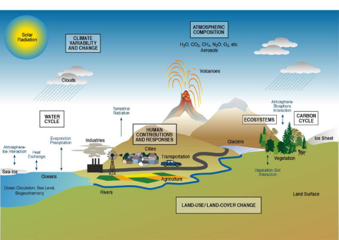
Environmental change caused by global warming involves a complex set of interactions between the subsystems of the earth system and human activities. These interactions vary across geographic scales. The timing and impact of future warming will not be the same for all regions of the Earth. Research methodologies that consider place and scale are therefore essential in understanding future environmental changes.
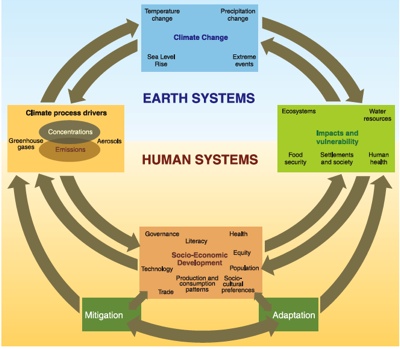
The continuum of geography permits a holistic view of earth systems analysis. Geographers are therefore perfectly positioned to answer questions concerning global warming and environmental change. Geographers are engaged in all aspects of environmental change research, from field monitoring glacier movements to computer modeling of future climates. Straddling both social and physical sciences, geographers play an important role in unwinding the social and economic drivers behind climate change.
Observing environmental change
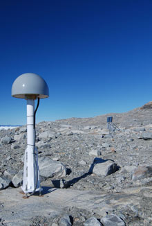
Geographers bring their unique talents to recording changes in earth systems. Geographical positioning systems (GPS) provide precise measurements of environmental change. For example, isostatic rebound of the earth's surface after the last ice age complicates measurements of melt from the expansive ice sheets that cover present-day Greenland and Antarctica. Recently, several GPS stations were deployed around the Greenland ice sheet to measure minute changes in earth surface elevation as a result of rebound. This data is being combined with that from sensors measuring elevation changes, glacial outflow rates and the mass balance to provide a more complete assessment of the sheets' melting.
Databases for analyzing the effects of climate change are large and complex. As databases documenting environmental changes across the earth are developed, geographers will provide the tools for teasing out spatial and temporal signals in the observations. Geographic Information Systems are well-suited for handling complex databases to map the potential spread of diseases, ecosystem changes, and sea-level rise as a result of global warming.
Analyzing environmental change
Geographer's have a number of tools and skills to analyze impact of environmental change on earth systems. Geographers are actively engaged in projects to identify and understand patterns of deforestation and habitat fragmentation. Geographer Eric Larsen has studied the decline of aspen trees in Yellowstone for several years. Though climate change was first suspected, he and ecologist William Ripple, realized that aspens outside the park flourished. If climate change was responsible, trees inside and outside the park would have suffered a decline. Analyzing cores from trees within the park, they found that most were 70 years old, aspens had apparently stopped regenerating around the 1930s
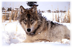
Between the late 1880s until the mid-1900s, more than bounty hunters killed 100,000 wolves in Wyoming and Montana. By the 1970s, the wolf was classified as an endangered species. A controversial reintroduction program brought 31 gray wolves back to the Yellowstone ecosystem. It appears that the removal of a top predator, allowed browsing elk populations to flourish and devastate young aspens. With the reintroduction, diversity and stability of the ecosystem appears to be on the rise.
Explaining environmental change
Geographers can play a significant role in hypothesis and theory development. Geographers are particularly suited for building numerical models of the complex coupling between the earth's surface and atmosphere above. Their strong field orientation and integrated methods will help hone the parameterization of climate models.
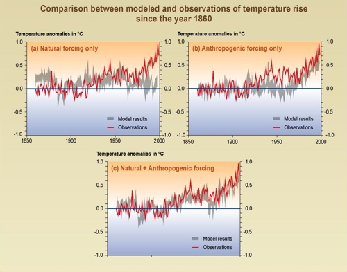
Geography's human-environment tradition provides a foundation for answering some of the most vexing issues of the global warming. The crux of the global warming issue is identifying the "fingerprint" of human activities in creating the enhanced greenhouse effect. For example, models that attempt to explain the warming experienced over the last several decades using only natural factors fail to adequately explain the actual pattern temperature. When human factors that influence warming are added, a much better correspondence with reality is uncovered.
Because geography uniquely straddles both physical and social sciences, geographers play an important role will play a role in future policy formulation and decision making. Geographers are well-suited for evaluating the costs and benefits of various global warming mitigation strategies.
Predicting environmental change
Climate models have demonstrated that the impact of global warming will vary across the earth. Geographers have been at the forefront of predicting the potential changes that our environment will undergo. Based on recent analyses, Geographer Jack Williams found that, we're headed for major change -- fast. He suggests areas that currently have a tropical climate will become warmer, pushing vegetation and animal life northward. Williams believes these changes will lead to the spread of insect-borne diseases like Malaria, increased catastrophic natural disasters and greater risks to human well-being. Temperatures rising just a few degrees will affect where particular plant and animal species will thrive. The question is if they will be able to migrate or adapt to a rapidly changing climate. If not, some face extinction.
Williams work predicts that many current climates may entirely vanish by the year 2100. He foresees "no-analog" communities of plants and animals arising from "novel" climates. No-analog communities consist of species that exist today but in differ net combinations from those presently inhabiting the earth. The species exist today, they have just been "reshuffled" into new combinations not found at the present. Such no-analog combinations have been found recorded in fossil pollen assemblages extracted from lake sediments dating from the late-glacial periods in North America. These seemingly odd past combinations of species are thought to be a product of of "novel" or no-analog climates, characterized by higher-than-present temperature seasonality. Professor Williams recognizes that with current trends in global warming, such new communities of species may be in our future. His climate models project the disappearance of many existing climates in tropical highlands and near the poles. Large swaths of the tropics and subtropics may develop new climates unlike anything seen today.
In coming chapters we'll examine the future geography of earth as predicted by geoscientists of all kinds and particularly physical geographers. You'll explore how earth's gaseous composition is predicted to change, how and where temperature changes occur, the impact of rising oceans, and the displacement of ecosystems. Though dire conditions are predicted, the challenges posed can be addressed ... and geographers will be at the forefront.


