
5.7: Theory of Plate Tectonics
- Page ID
- 2523
\( \newcommand{\vecs}[1]{\overset { \scriptstyle \rightharpoonup} {\mathbf{#1}} } \)
\( \newcommand{\vecd}[1]{\overset{-\!-\!\rightharpoonup}{\vphantom{a}\smash {#1}}} \)
\( \newcommand{\id}{\mathrm{id}}\) \( \newcommand{\Span}{\mathrm{span}}\)
( \newcommand{\kernel}{\mathrm{null}\,}\) \( \newcommand{\range}{\mathrm{range}\,}\)
\( \newcommand{\RealPart}{\mathrm{Re}}\) \( \newcommand{\ImaginaryPart}{\mathrm{Im}}\)
\( \newcommand{\Argument}{\mathrm{Arg}}\) \( \newcommand{\norm}[1]{\| #1 \|}\)
\( \newcommand{\inner}[2]{\langle #1, #2 \rangle}\)
\( \newcommand{\Span}{\mathrm{span}}\)
\( \newcommand{\id}{\mathrm{id}}\)
\( \newcommand{\Span}{\mathrm{span}}\)
\( \newcommand{\kernel}{\mathrm{null}\,}\)
\( \newcommand{\range}{\mathrm{range}\,}\)
\( \newcommand{\RealPart}{\mathrm{Re}}\)
\( \newcommand{\ImaginaryPart}{\mathrm{Im}}\)
\( \newcommand{\Argument}{\mathrm{Arg}}\)
\( \newcommand{\norm}[1]{\| #1 \|}\)
\( \newcommand{\inner}[2]{\langle #1, #2 \rangle}\)
\( \newcommand{\Span}{\mathrm{span}}\) \( \newcommand{\AA}{\unicode[.8,0]{x212B}}\)
\( \newcommand{\vectorA}[1]{\vec{#1}} % arrow\)
\( \newcommand{\vectorAt}[1]{\vec{\text{#1}}} % arrow\)
\( \newcommand{\vectorB}[1]{\overset { \scriptstyle \rightharpoonup} {\mathbf{#1}} } \)
\( \newcommand{\vectorC}[1]{\textbf{#1}} \)
\( \newcommand{\vectorD}[1]{\overrightarrow{#1}} \)
\( \newcommand{\vectorDt}[1]{\overrightarrow{\text{#1}}} \)
\( \newcommand{\vectE}[1]{\overset{-\!-\!\rightharpoonup}{\vphantom{a}\smash{\mathbf {#1}}}} \)
\( \newcommand{\vecs}[1]{\overset { \scriptstyle \rightharpoonup} {\mathbf{#1}} } \)
\( \newcommand{\vecd}[1]{\overset{-\!-\!\rightharpoonup}{\vphantom{a}\smash {#1}}} \)
\(\newcommand{\avec}{\mathbf a}\) \(\newcommand{\bvec}{\mathbf b}\) \(\newcommand{\cvec}{\mathbf c}\) \(\newcommand{\dvec}{\mathbf d}\) \(\newcommand{\dtil}{\widetilde{\mathbf d}}\) \(\newcommand{\evec}{\mathbf e}\) \(\newcommand{\fvec}{\mathbf f}\) \(\newcommand{\nvec}{\mathbf n}\) \(\newcommand{\pvec}{\mathbf p}\) \(\newcommand{\qvec}{\mathbf q}\) \(\newcommand{\svec}{\mathbf s}\) \(\newcommand{\tvec}{\mathbf t}\) \(\newcommand{\uvec}{\mathbf u}\) \(\newcommand{\vvec}{\mathbf v}\) \(\newcommand{\wvec}{\mathbf w}\) \(\newcommand{\xvec}{\mathbf x}\) \(\newcommand{\yvec}{\mathbf y}\) \(\newcommand{\zvec}{\mathbf z}\) \(\newcommand{\rvec}{\mathbf r}\) \(\newcommand{\mvec}{\mathbf m}\) \(\newcommand{\zerovec}{\mathbf 0}\) \(\newcommand{\onevec}{\mathbf 1}\) \(\newcommand{\real}{\mathbb R}\) \(\newcommand{\twovec}[2]{\left[\begin{array}{r}#1 \\ #2 \end{array}\right]}\) \(\newcommand{\ctwovec}[2]{\left[\begin{array}{c}#1 \\ #2 \end{array}\right]}\) \(\newcommand{\threevec}[3]{\left[\begin{array}{r}#1 \\ #2 \\ #3 \end{array}\right]}\) \(\newcommand{\cthreevec}[3]{\left[\begin{array}{c}#1 \\ #2 \\ #3 \end{array}\right]}\) \(\newcommand{\fourvec}[4]{\left[\begin{array}{r}#1 \\ #2 \\ #3 \\ #4 \end{array}\right]}\) \(\newcommand{\cfourvec}[4]{\left[\begin{array}{c}#1 \\ #2 \\ #3 \\ #4 \end{array}\right]}\) \(\newcommand{\fivevec}[5]{\left[\begin{array}{r}#1 \\ #2 \\ #3 \\ #4 \\ #5 \\ \end{array}\right]}\) \(\newcommand{\cfivevec}[5]{\left[\begin{array}{c}#1 \\ #2 \\ #3 \\ #4 \\ #5 \\ \end{array}\right]}\) \(\newcommand{\mattwo}[4]{\left[\begin{array}{rr}#1 \amp #2 \\ #3 \amp #4 \\ \end{array}\right]}\) \(\newcommand{\laspan}[1]{\text{Span}\{#1\}}\) \(\newcommand{\bcal}{\cal B}\) \(\newcommand{\ccal}{\cal C}\) \(\newcommand{\scal}{\cal S}\) \(\newcommand{\wcal}{\cal W}\) \(\newcommand{\ecal}{\cal E}\) \(\newcommand{\coords}[2]{\left\{#1\right\}_{#2}}\) \(\newcommand{\gray}[1]{\color{gray}{#1}}\) \(\newcommand{\lgray}[1]{\color{lightgray}{#1}}\) \(\newcommand{\rank}{\operatorname{rank}}\) \(\newcommand{\row}{\text{Row}}\) \(\newcommand{\col}{\text{Col}}\) \(\renewcommand{\row}{\text{Row}}\) \(\newcommand{\nul}{\text{Nul}}\) \(\newcommand{\var}{\text{Var}}\) \(\newcommand{\corr}{\text{corr}}\) \(\newcommand{\len}[1]{\left|#1\right|}\) \(\newcommand{\bbar}{\overline{\bvec}}\) \(\newcommand{\bhat}{\widehat{\bvec}}\) \(\newcommand{\bperp}{\bvec^\perp}\) \(\newcommand{\xhat}{\widehat{\xvec}}\) \(\newcommand{\vhat}{\widehat{\vvec}}\) \(\newcommand{\uhat}{\widehat{\uvec}}\) \(\newcommand{\what}{\widehat{\wvec}}\) \(\newcommand{\Sighat}{\widehat{\Sigma}}\) \(\newcommand{\lt}{<}\) \(\newcommand{\gt}{>}\) \(\newcommand{\amp}{&}\) \(\definecolor{fillinmathshade}{gray}{0.9}\)When the concept of seafloor spreading came along, scientists recognized that it was the mechanism to explain how continents could move around Earth’s surface. Like the scientists before us, we will now merge the ideas of continental drift and seafloor spreading into the theory of plate tectonics.
Watch this video about continental drift and the mechanism of seafloor spreading create plate tectonics.
EARTH’S TECTONIC PLATES
Seafloor and continents move around on Earth’s surface, but what is actually moving? What portion of the Earth makes up the “plates” in plate tectonics? This question was also answered because of technology developed during war times – in this case, the Cold War. The plates are made up of the lithosphere.
During the 1950s and early 1960s, scientists set up seismograph networks to see if enemy nations were testing atomic bombs. These seismographs also recorded all of the earthquakes around the planet. The seismic records could be used to locate an earthquake’s epicenter, the point on Earth’s surface directly above the place where the earthquake occurs.
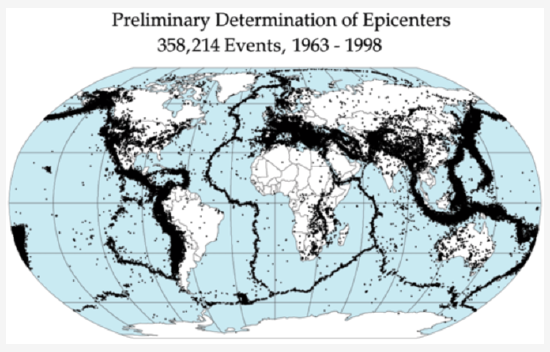
Figure 1. Earthquakes outline the plates.
Earthquake epicenters outline the plates. Mid-ocean ridges, trenches, and large faults mark the edges of the plates, and this is where earthquakes occur (figure 1).
The lithosphere is divided into a dozen major and several minor plates (figure 2). The plates’ edges can be drawn by connecting the dots that mark earthquakes’ epicenters. A single plate can be made of all oceanic lithosphere or all continental lithosphere, but nearly all plates are made of a combination of both.
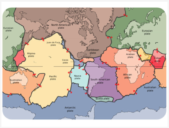
Figure 2. The lithospheric plates and their names. The arrows show whether the plates are moving apart, moving together, or sliding past each other.
Movement of the plates over Earth’s surface is termed plate tectonics. Plates move at a rate of a few centimeters a year, about the same rate fingernails grow.
HOW PLATES MOVE
If seafloor spreading drives the plates, what drives seafloor spreading? Picture two convection cells side-by-side in the mantle, similar to the illustration in figure 3.
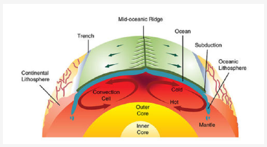
Figure 3. Mantle convection drives plate tectonics. Hot material rises at mid-ocean ridges and sinks at deep sea trenches, which keeps the plates moving along the Earth’s surface.
- Hot mantle from the two adjacent cells rises at the ridge axis, creating new ocean crust.
- The top limb of the convection cell moves horizontally away from the ridge crest, as does the new seafloor.
- The outer limbs of the convection cells plunge down into the deeper mantle, dragging oceanic crust as well. This takes place at the deep sea trenches.
- The material sinks to the core and moves horizontally.
- The material heats up and reaches the zone where it rises again.
Check out this animation of mantle convection and watch this video:
PLATE BOUNDARIES
Plate boundaries are the edges where two plates meet. Most geologic activities, including volcanoes, earthquakes, and mountain building, take place at plate boundaries. How can two plates move relative to each other?
- Divergent plate boundaries: the two plates move away from each other.
- Convergent plate boundaries: the two plates move towards each other.
- Transform plate boundaries: the two plates slip past each other.
The type of plate boundary and the type of crust found on each side of the boundary determines what sort of geologic activity will be found there.
Divergent Plate Boundaries
Plates move apart at mid-ocean ridges where new seafloor forms. Between the two plates is a rift valley. Lava flows at the surface cool rapidly to become basalt, but deeper in the crust, magma cools more slowly to form gabbro. So the entire ridge system is made up of igneous rock that is either extrusive or intrusive. Earthquakes are common at mid-ocean ridges since the movement of magma and oceanic crust results in crustal shaking. The vast majority of mid-ocean ridges are located deep below the sea (figure 4).
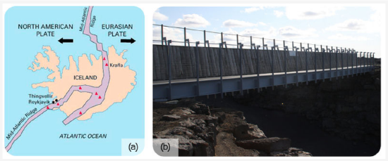
Figure 4. (a) Iceland is the one location where the ridge is located on land: the Mid-Atlantic Ridge separates the North American and Eurasian plates; (b) The rift valley in the Mid-Atlantic Ridge on Iceland.
Check out these animations:
- Divergent plate boundary at mid-ocean ridge
- Divergent plate boundary
Can divergent plate boundaries occur within a continent? What is the result? Incontinental rifting (figure 5), magma rises beneath the continent, causing it to become thinner, break, and ultimately split apart. New ocean crust erupts in the void, creating an ocean between continents.
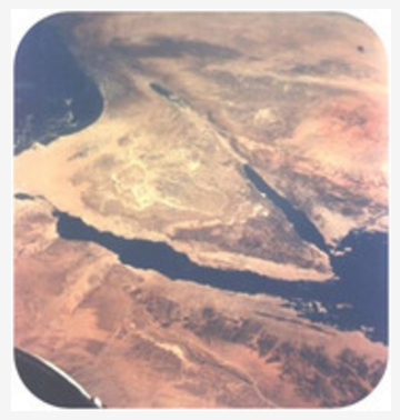
Figure 5. The Arabian, Indian, and African plates are rifting apart, forming the Great Rift Valley in Africa. The Dead Sea fills the rift with seawater.
Convergent Plate Boundaries
When two plates converge, the result depends on the type of lithosphere the plates are made of. No matter what, smashing two enormous slabs of lithosphere together results in magma generation and earthquakes.
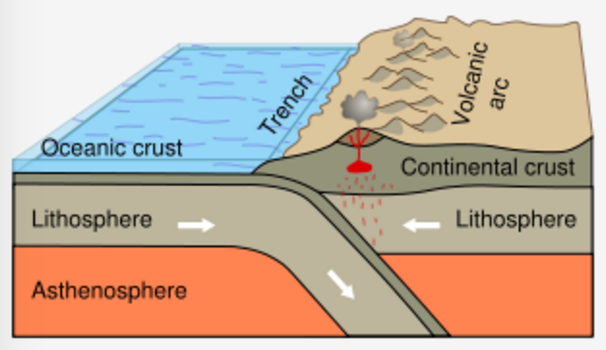
Figure 6. Subduction of an oceanic plate beneath a continental plate causes earthquakes and forms a line of volcanoes known as a continental arc.
Ocean-Continent
When oceanic crust converges with continental crust, the denser oceanic plate plunges beneath the continental plate. This process, called subduction, occurs at the oceanic trenches (figure 6). The entire region is known as a subduction zone. Subduction zones have a lot of intense earthquakes and volcanic eruptions. The subducting plate causes melting in the mantle. The magma rises and erupts, creating volcanoes. These coastal volcanic mountains are found in a line above the subducting plate (figure 7). The volcanoes are known as a continental arc.
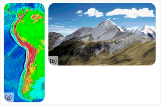
Figure 7. (a) At the trench lining the western margin of South America, the Nazca plate is subducting beneath the South American plate, resulting in the Andes Mountains (brown and red uplands); (b) Convergence has pushed up limestone in the Andes Mountains where volcanoes are common.
The movement of crust and magma causes earthquakes. Look at this map of earthquake epicenters at subduction zones. This animation shows the relationship between subduction of the lithosphere and creation of a volcanic arc.
The volcanoes of northeastern California—Lassen Peak, Mount Shasta, and Medicine Lake volcano—along with the rest of the Cascade Mountains of the Pacific Northwest are the result of subduction of the Juan de Fuca plate beneath the North American plate (figure 8). The Juan de Fuca plate is created by seafloor spreading just offshore at the Juan de Fuca ridge.
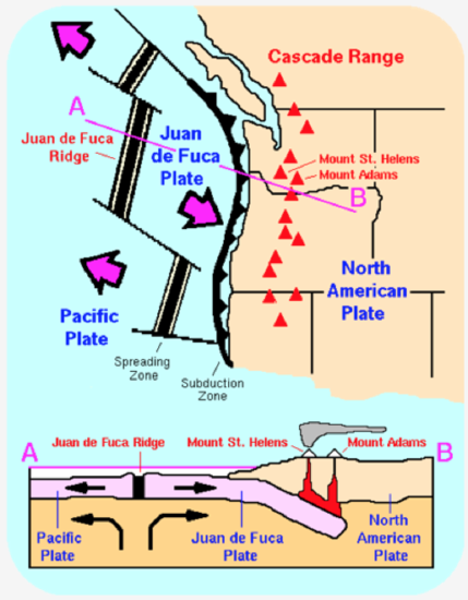
Figure 8. The Cascade Mountains of the Pacific Northwest are a continental arc.
If the magma at a continental arc is felsic, it may be too viscous (thick) to rise through the crust. The magma will cool slowly to form granite or granodiorite. These large bodies of intrusive igneous rocks are called batholiths, which may someday be uplifted to form a mountain range (figure 9).
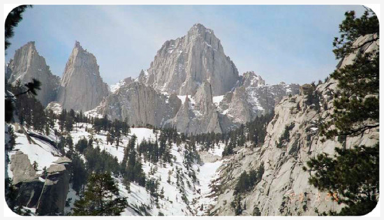
Figure 9. The Sierra Nevada batholith cooled beneath a volcanic arc roughly 200 million years ago. The rock is well exposed here at Mount Whitney. Similar batholiths are likely forming beneath the Andes and Cascades today.
Ocean-Ocean
When two oceanic plates converge, the older, denser plate will subduct into the mantle. An ocean trench marks the location where the plate is pushed down into the mantle. The line of volcanoes that grows on the upper oceanic plate is an island arc. Do you think earthquakes are common in these regions (figure 10)?
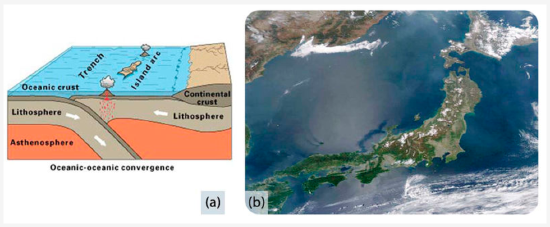
Figure 10. (a) Subduction of an ocean plate beneath an ocean plate results in a volcanic island arc, an ocean trench and many earthquakes. (b) Japan is an arc-shaped island arc composed of volcanoes off the Asian mainland, as seen in this satellite image.
Check out this animation of an ocean continent plate boundary.
Continent-Continent
Continental plates are too buoyant to subduct. What happens to continental material when it collides? Since it has nowhere to go but up, this creates some of the world’s largest mountains ranges (figure 11). Magma cannot penetrate this thick crust so there are no volcanoes, although the magma stays in the crust. Metamorphic rocks are common because of the stress the continental crust experiences. With enormous slabs of crust smashing together, continent-continent collisions bring on numerous and large earthquakes.
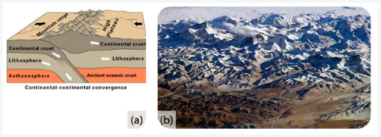
Figure 11. (a) In continent-continent convergence, the plates push upward to create a high mountain range. (b) The world’s highest mountains, the Himalayas, are the result of the collision of the Indian Plate with the Eurasian Plate, seen in this photo from the International Space Station.
Check out this short animation of the Indian Plate colliding with the Eurasian Plate.
Watch this animation of the Himalaya rising.
The Appalachian Mountains are the remnants of a large mountain range that was created when North America rammed into Eurasia about 250 million years ago.
Transform Plate Boundaries
Transform plate boundaries are seen as transform faults, where two plates move past each other in opposite directions. Transform faults on continents bring massive earthquakes (figure 12).
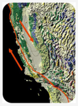
Figure 12. At the San Andreas Fault in California, the Pacific Plate is sliding northeast relative to the North American plate, which is moving southwest. At the northern end of the picture, the transform boundary turns into a subduction zone.
California is very geologically active. What are the three major plate boundaries in or near California (figure 13)?
- A transform plate boundary between the Pacific and North American plates creates the San Andreas Fault, the world’s most notorious transform fault.
- Just offshore, a divergent plate boundary, Juan de Fuca ridge, creates the Juan de Fuca plate.
- A convergent plate boundary between the Juan de Fuca oceanic plate and the North American continental plate creates the Cascades volcanoes.
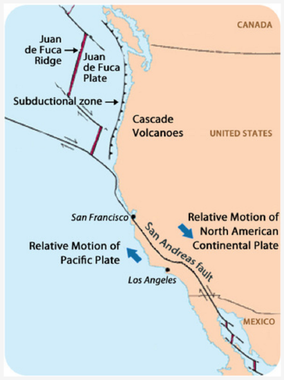
Figure 13. This map shows the three major plate boundaries in or near California.
A brief review of the three types of plate boundaries and the structures that are found there is the subject of this wordless video.
EARTH’S CHANGING SURFACE
Geologists know that Wegener was right because the movements of continents explain so much about the geology we see. Most of the geologic activity that we see on the planet today is because of the interactions of the moving plates.
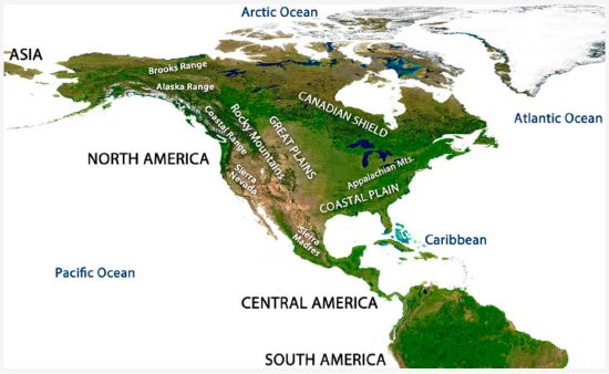
Figure 14. Mountain ranges of North America.
In the map of North America (figure 14), where are the mountain ranges located? Using what you have learned about plate tectonics, try to answer the following questions:
- What is the geologic origin of the Cascades Range? The Cascades are a chain of volcanoes in the Pacific Northwest. They are not labelled on the diagram but they lie between the Sierra Nevada and the Coastal Range.
- What is the geologic origin of the Sierra Nevada? (Hint: These mountains are made of granitic intrusions.)
- What is the geologic origin of the Appalachian Mountains along the Eastern US?
Remember that Wegener used the similarity of the mountains on the west and east sides of the Atlantic as evidence for his continental drift hypothesis. The Appalachian mountains formed at a convergent plate boundary as Pangaea came together (figure 15).
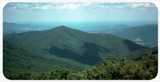
Figure 15. About 200 million years ago, the Appalachian Mountains of eastern North America were probably once as high as the Himalaya, but they have been weathered and eroded significantly since the breakup of Pangaea.
Before Pangaea came together, the continents were separated by an ocean where the Atlantic is now. The proto-Atlantic ocean shrank as the Pacific ocean grew. Currently, the Pacific is shrinking as the Atlantic is growing. This supercontinent cycle is responsible for most of the geologic features that we see and many more that are long gone (figure 16).
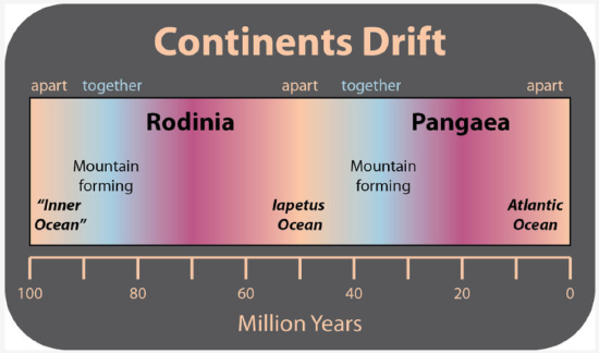
Figure 16. Scientists think that the creation and breakup of a supercontinent takes place about every 500 million years. The supercontinent before Pangaea was Rodinia. A new continent will form as the Pacific ocean disappears.
This animation shows the movement of continents over the past 600 million years beginning with the breakup of Rodinia.
LESSON SUMMARY
- Plates of lithosphere move because of convection currents in the mantle. One type of motion is produced by seafloor spreading.
- Plate boundaries can be located by outlining earthquake epicenters.
- Plates interact at three types of plate boundaries: divergent, convergent and transform.
- Most of the Earth’s geologic activity takes place at plate boundaries.
- At a divergent boundary, volcanic activity produces a mid ocean ridge and small earthquakes.
- At a convergent boundary with at least one oceanic plate, an ocean trench, a chain of volcanoes develops and many earthquakes occur.
- At a convergent boundary where both plates are continental, mountain ranges grow and earthquakes are common.
- At a transform boundary, there is a transform fault and massive earthquakes occur but there are no volcanoes.
- Processes acting over long periods of time create Earth’s geographic features.
REFLECTION QUESTIONS
- What skill does this content help you develop?
- What are the key topics covered in this content?
- How can the content in this section help you demonstrate mastery of a specific skill?
- What questions do you have about this content?
Contributors and Attributions
Original content from Kimberly Schulte (Columbia Basin College) and supplemented by Lumen Learning. The content on this page is copyrighted under a Creative Commons Attribution 4.0 International license.