16.7: Soil Orders
- Page ID
- 21799
\( \newcommand{\vecs}[1]{\overset { \scriptstyle \rightharpoonup} {\mathbf{#1}} } \)
\( \newcommand{\vecd}[1]{\overset{-\!-\!\rightharpoonup}{\vphantom{a}\smash {#1}}} \)
\( \newcommand{\dsum}{\displaystyle\sum\limits} \)
\( \newcommand{\dint}{\displaystyle\int\limits} \)
\( \newcommand{\dlim}{\displaystyle\lim\limits} \)
\( \newcommand{\id}{\mathrm{id}}\) \( \newcommand{\Span}{\mathrm{span}}\)
( \newcommand{\kernel}{\mathrm{null}\,}\) \( \newcommand{\range}{\mathrm{range}\,}\)
\( \newcommand{\RealPart}{\mathrm{Re}}\) \( \newcommand{\ImaginaryPart}{\mathrm{Im}}\)
\( \newcommand{\Argument}{\mathrm{Arg}}\) \( \newcommand{\norm}[1]{\| #1 \|}\)
\( \newcommand{\inner}[2]{\langle #1, #2 \rangle}\)
\( \newcommand{\Span}{\mathrm{span}}\)
\( \newcommand{\id}{\mathrm{id}}\)
\( \newcommand{\Span}{\mathrm{span}}\)
\( \newcommand{\kernel}{\mathrm{null}\,}\)
\( \newcommand{\range}{\mathrm{range}\,}\)
\( \newcommand{\RealPart}{\mathrm{Re}}\)
\( \newcommand{\ImaginaryPart}{\mathrm{Im}}\)
\( \newcommand{\Argument}{\mathrm{Arg}}\)
\( \newcommand{\norm}[1]{\| #1 \|}\)
\( \newcommand{\inner}[2]{\langle #1, #2 \rangle}\)
\( \newcommand{\Span}{\mathrm{span}}\) \( \newcommand{\AA}{\unicode[.8,0]{x212B}}\)
\( \newcommand{\vectorA}[1]{\vec{#1}} % arrow\)
\( \newcommand{\vectorAt}[1]{\vec{\text{#1}}} % arrow\)
\( \newcommand{\vectorB}[1]{\overset { \scriptstyle \rightharpoonup} {\mathbf{#1}} } \)
\( \newcommand{\vectorC}[1]{\textbf{#1}} \)
\( \newcommand{\vectorD}[1]{\overrightarrow{#1}} \)
\( \newcommand{\vectorDt}[1]{\overrightarrow{\text{#1}}} \)
\( \newcommand{\vectE}[1]{\overset{-\!-\!\rightharpoonup}{\vphantom{a}\smash{\mathbf {#1}}}} \)
\( \newcommand{\vecs}[1]{\overset { \scriptstyle \rightharpoonup} {\mathbf{#1}} } \)
\(\newcommand{\longvect}{\overrightarrow}\)
\( \newcommand{\vecd}[1]{\overset{-\!-\!\rightharpoonup}{\vphantom{a}\smash {#1}}} \)
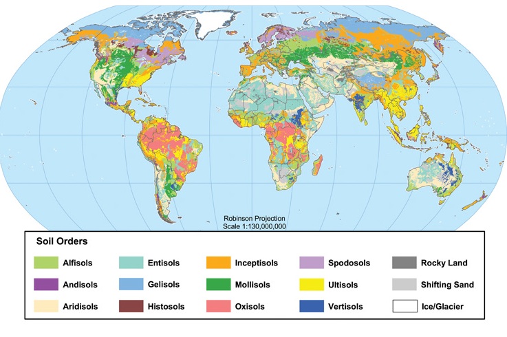
\(\newcommand{\avec}{\mathbf a}\) \(\newcommand{\bvec}{\mathbf b}\) \(\newcommand{\cvec}{\mathbf c}\) \(\newcommand{\dvec}{\mathbf d}\) \(\newcommand{\dtil}{\widetilde{\mathbf d}}\) \(\newcommand{\evec}{\mathbf e}\) \(\newcommand{\fvec}{\mathbf f}\) \(\newcommand{\nvec}{\mathbf n}\) \(\newcommand{\pvec}{\mathbf p}\) \(\newcommand{\qvec}{\mathbf q}\) \(\newcommand{\svec}{\mathbf s}\) \(\newcommand{\tvec}{\mathbf t}\) \(\newcommand{\uvec}{\mathbf u}\) \(\newcommand{\vvec}{\mathbf v}\) \(\newcommand{\wvec}{\mathbf w}\) \(\newcommand{\xvec}{\mathbf x}\) \(\newcommand{\yvec}{\mathbf y}\) \(\newcommand{\zvec}{\mathbf z}\) \(\newcommand{\rvec}{\mathbf r}\) \(\newcommand{\mvec}{\mathbf m}\) \(\newcommand{\zerovec}{\mathbf 0}\) \(\newcommand{\onevec}{\mathbf 1}\) \(\newcommand{\real}{\mathbb R}\) \(\newcommand{\twovec}[2]{\left[\begin{array}{r}#1 \\ #2 \end{array}\right]}\) \(\newcommand{\ctwovec}[2]{\left[\begin{array}{c}#1 \\ #2 \end{array}\right]}\) \(\newcommand{\threevec}[3]{\left[\begin{array}{r}#1 \\ #2 \\ #3 \end{array}\right]}\) \(\newcommand{\cthreevec}[3]{\left[\begin{array}{c}#1 \\ #2 \\ #3 \end{array}\right]}\) \(\newcommand{\fourvec}[4]{\left[\begin{array}{r}#1 \\ #2 \\ #3 \\ #4 \end{array}\right]}\) \(\newcommand{\cfourvec}[4]{\left[\begin{array}{c}#1 \\ #2 \\ #3 \\ #4 \end{array}\right]}\) \(\newcommand{\fivevec}[5]{\left[\begin{array}{r}#1 \\ #2 \\ #3 \\ #4 \\ #5 \\ \end{array}\right]}\) \(\newcommand{\cfivevec}[5]{\left[\begin{array}{c}#1 \\ #2 \\ #3 \\ #4 \\ #5 \\ \end{array}\right]}\) \(\newcommand{\mattwo}[4]{\left[\begin{array}{rr}#1 \amp #2 \\ #3 \amp #4 \\ \end{array}\right]}\) \(\newcommand{\laspan}[1]{\text{Span}\{#1\}}\) \(\newcommand{\bcal}{\cal B}\) \(\newcommand{\ccal}{\cal C}\) \(\newcommand{\scal}{\cal S}\) \(\newcommand{\wcal}{\cal W}\) \(\newcommand{\ecal}{\cal E}\) \(\newcommand{\coords}[2]{\left\{#1\right\}_{#2}}\) \(\newcommand{\gray}[1]{\color{gray}{#1}}\) \(\newcommand{\lgray}[1]{\color{lightgray}{#1}}\) \(\newcommand{\rank}{\operatorname{rank}}\) \(\newcommand{\row}{\text{Row}}\) \(\newcommand{\col}{\text{Col}}\) \(\renewcommand{\row}{\text{Row}}\) \(\newcommand{\nul}{\text{Nul}}\) \(\newcommand{\var}{\text{Var}}\) \(\newcommand{\corr}{\text{corr}}\) \(\newcommand{\len}[1]{\left|#1\right|}\) \(\newcommand{\bbar}{\overline{\bvec}}\) \(\newcommand{\bhat}{\widehat{\bvec}}\) \(\newcommand{\bperp}{\bvec^\perp}\) \(\newcommand{\xhat}{\widehat{\xvec}}\) \(\newcommand{\vhat}{\widehat{\vvec}}\) \(\newcommand{\uhat}{\widehat{\uvec}}\) \(\newcommand{\what}{\widehat{\wvec}}\) \(\newcommand{\Sighat}{\widehat{\Sigma}}\) \(\newcommand{\lt}{<}\) \(\newcommand{\gt}{>}\) \(\newcommand{\amp}{&}\) \(\definecolor{fillinmathshade}{gray}{0.9}\)The are many different ways in which soils have been classified, mostly at the national level for individual countries. The brief discussion below reflects the way soils are classified by the United States Department of Agriculture. The following is intended to give you a basic understanding of the major categories in this classification system called soil orders and the environments under which they form. For a comprehensive description of how soils are classified in the United States, see the Soil Taxonomy Handbook (only for those of you aiming to learn more about soil classification than you ever wanted to know!)
Entisol
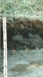
Entisols, like this one found in southwestern Wisconsin, are soils lacking horizons because their parent material has only recently accumulated. Entisols also form where the parent material is quartz sand, in which horizons do not easily form. They have a wide geographic distribution and can be found in any climate and under any vegetation. Entisols and Inceptisols are often found on floodplains, delta deposits, or steep slopes where parent material has difficulty accumulating.
Inceptisol
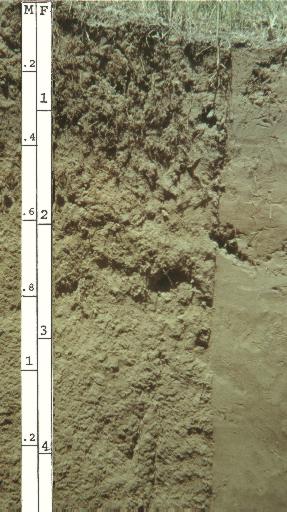
Inceptisols are soils just starting to show horizon development because the soil is quite young. You can see the differentiation of layers in an inceptisol formed on colluvium in West Virginia on the right. Inceptisols, like Entisols, are found in any type of environment and are commonly found forming in alluvium on floodplains and delta deposits.
Histosol
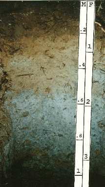
Histosols have a very high content of organic matter in the dark upper layer of the profile. Found in many different environments from the tundra to the tropics, Histosols form in places where organic matter is slow to decompose and thus accumulates over time such as bogs and swamps. They are often "mined" for peat which is dried and burned as fuel.
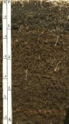
Aridisol
Aridisols are soils of arid and semiarid environments where moisture is scarce. They are typically light in color as there is little vegetation to add organic matter to the soil profile. A negative moisture balance in these soils inhibits eluviation. Calcification and salinization are important soil forming processes acting in these soils. Soil horizons are weakly developed and sodium is often high in concentration making them alkaline. The coarse texture of aridisols makes it difficult to retain much moisture. Aridisols can be quite fertile soil if irrigation is properly used. Used improperly, a salt crust can form on the soil. Most aridisols are used for grazing.
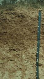
Andisol
Andisols are soils developing in parent material containing at least fifty percent volcanic ash. The layers of ash can be seen in this Andisol from Hawaii. Naturally fertile soils, they support a dense natural cover in moist climates. Andisols occur around individual volcanoes created from andesite-rich magma. They are common on the volcanic islands and mountains of "The Ring of Fire", that encircles the Pacific Ocean from North America through Japan.
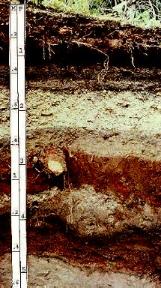
Vertisol
Vertisols are dark black soils rich in expandable clay minerals. The clay readily swells upon wetting and shrinks when dried. Though found in every type of climate, they are often found in steppe and wet/dry tropical climates where the soil develops deep cracks as it dries. Surface fragments fall into the cracks and are "swallowed" when the soil swells upon wetting. The soil then develops an "inverted profile" with organic material that is typically located near the surface of the profile is now found at depth.
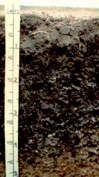
Mollisol
Mollisols are among the most fertile soils on the Earth. Born under grassland vegetation, these soils are well-known for their dark brown to black organic rich surface layers. These soils have a granular structure and soft consistency when dry. Mollisols are rich in calcium and others nutrients, and generally posses high moisture retention. Calcium nodules are found near the base of the soil as calcium carbonate precipitates out of soil water. Mollisols are found in the drier portions of the humid continental climate through the steppe climate.
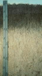
Spodosol
Spodosol soil is commonly found in cool, moist environments under coniferous forest vegetation. Surface litter composed of pine needles breaks down in the presence of water to form a weak organic acid. Acidic soil water removes base ions in solution to create an acidic soil. Easily dissolved materials are leached from surface layers leaving behind the most resistant material like quartz, creating an ashy-gray near-surface layer. Layers at depth are stained with iron and aluminum oxides.
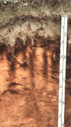
Alfisol
Alfisols are soils developed under temperate forests of the humid midlatitudes. Eluviation is moderate and base status is fairly high in these soils. Common to the humid continental (like the one in Michigan on the left) and humid subtropical climates, these soils are well-developed and contain a subsurface layer of clay called an argillic horizon. Some alfisols are found in the wet/dry tropical climate of Africa, South America, Australia, and Southeast Asia. Having a favorable moisture balance and good fertility, they are very productive soils for agriculture. In fact, they have been successfully used for farming in China and Europe for thousands of years. Alfisols are abundant on older glacial deposits in the United States, and loess deposits in and near the Mississippi embayment.
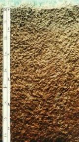
Ultisol
Ultisols share many of the same properties as Oxisols. Highly weathered soils, they are often red/yellow in color reflecting the oxidation of iron and aluminum. Found in the moister portions of the Humid Subtropical climate, they have a illuvial clay layer which distinguishes them from Oxisols which do not.
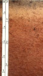
Oxisol
Oxisol soil is found in warm, rainy climates under broadleaf, evergreen vegetation like that found in the rain forest. Chemical weathering (especially oxidation) in the presence of warm temperatures combined with heavy rainfall creates a soil rich in iron and aluminum oxides called "sesquioxides". A rich diversity of decomposers, rapid uptake by vegetation, and heavy precipitation quickly removes nutrients from the soil. What is left is a nutrient poor soil, not well-suited for agriculture. Cleared of vegetation, the exposed surface is easily eroded.
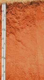
Which of the following soil forming processes created this oxisol?
Laterization, Podzolization, or Calcification?
- Answer
-
Laterization
Gelisol
Gelisol soil develops on permafrost and common to the tundra. These soils consist of mineral or organic material, or both and have experienced cryoturbation (frost churning) due to annual freeze-thaw cycles.
