
6.8: Review and Additional Resources
- Page ID
- 21709
\( \newcommand{\vecs}[1]{\overset { \scriptstyle \rightharpoonup} {\mathbf{#1}} } \)
\( \newcommand{\vecd}[1]{\overset{-\!-\!\rightharpoonup}{\vphantom{a}\smash {#1}}} \)
\( \newcommand{\id}{\mathrm{id}}\) \( \newcommand{\Span}{\mathrm{span}}\)
( \newcommand{\kernel}{\mathrm{null}\,}\) \( \newcommand{\range}{\mathrm{range}\,}\)
\( \newcommand{\RealPart}{\mathrm{Re}}\) \( \newcommand{\ImaginaryPart}{\mathrm{Im}}\)
\( \newcommand{\Argument}{\mathrm{Arg}}\) \( \newcommand{\norm}[1]{\| #1 \|}\)
\( \newcommand{\inner}[2]{\langle #1, #2 \rangle}\)
\( \newcommand{\Span}{\mathrm{span}}\)
\( \newcommand{\id}{\mathrm{id}}\)
\( \newcommand{\Span}{\mathrm{span}}\)
\( \newcommand{\kernel}{\mathrm{null}\,}\)
\( \newcommand{\range}{\mathrm{range}\,}\)
\( \newcommand{\RealPart}{\mathrm{Re}}\)
\( \newcommand{\ImaginaryPart}{\mathrm{Im}}\)
\( \newcommand{\Argument}{\mathrm{Arg}}\)
\( \newcommand{\norm}[1]{\| #1 \|}\)
\( \newcommand{\inner}[2]{\langle #1, #2 \rangle}\)
\( \newcommand{\Span}{\mathrm{span}}\) \( \newcommand{\AA}{\unicode[.8,0]{x212B}}\)
\( \newcommand{\vectorA}[1]{\vec{#1}} % arrow\)
\( \newcommand{\vectorAt}[1]{\vec{\text{#1}}} % arrow\)
\( \newcommand{\vectorB}[1]{\overset { \scriptstyle \rightharpoonup} {\mathbf{#1}} } \)
\( \newcommand{\vectorC}[1]{\textbf{#1}} \)
\( \newcommand{\vectorD}[1]{\overrightarrow{#1}} \)
\( \newcommand{\vectorDt}[1]{\overrightarrow{\text{#1}}} \)
\( \newcommand{\vectE}[1]{\overset{-\!-\!\rightharpoonup}{\vphantom{a}\smash{\mathbf {#1}}}} \)
\( \newcommand{\vecs}[1]{\overset { \scriptstyle \rightharpoonup} {\mathbf{#1}} } \)
\( \newcommand{\vecd}[1]{\overset{-\!-\!\rightharpoonup}{\vphantom{a}\smash {#1}}} \)
\(\newcommand{\avec}{\mathbf a}\) \(\newcommand{\bvec}{\mathbf b}\) \(\newcommand{\cvec}{\mathbf c}\) \(\newcommand{\dvec}{\mathbf d}\) \(\newcommand{\dtil}{\widetilde{\mathbf d}}\) \(\newcommand{\evec}{\mathbf e}\) \(\newcommand{\fvec}{\mathbf f}\) \(\newcommand{\nvec}{\mathbf n}\) \(\newcommand{\pvec}{\mathbf p}\) \(\newcommand{\qvec}{\mathbf q}\) \(\newcommand{\svec}{\mathbf s}\) \(\newcommand{\tvec}{\mathbf t}\) \(\newcommand{\uvec}{\mathbf u}\) \(\newcommand{\vvec}{\mathbf v}\) \(\newcommand{\wvec}{\mathbf w}\) \(\newcommand{\xvec}{\mathbf x}\) \(\newcommand{\yvec}{\mathbf y}\) \(\newcommand{\zvec}{\mathbf z}\) \(\newcommand{\rvec}{\mathbf r}\) \(\newcommand{\mvec}{\mathbf m}\) \(\newcommand{\zerovec}{\mathbf 0}\) \(\newcommand{\onevec}{\mathbf 1}\) \(\newcommand{\real}{\mathbb R}\) \(\newcommand{\twovec}[2]{\left[\begin{array}{r}#1 \\ #2 \end{array}\right]}\) \(\newcommand{\ctwovec}[2]{\left[\begin{array}{c}#1 \\ #2 \end{array}\right]}\) \(\newcommand{\threevec}[3]{\left[\begin{array}{r}#1 \\ #2 \\ #3 \end{array}\right]}\) \(\newcommand{\cthreevec}[3]{\left[\begin{array}{c}#1 \\ #2 \\ #3 \end{array}\right]}\) \(\newcommand{\fourvec}[4]{\left[\begin{array}{r}#1 \\ #2 \\ #3 \\ #4 \end{array}\right]}\) \(\newcommand{\cfourvec}[4]{\left[\begin{array}{c}#1 \\ #2 \\ #3 \\ #4 \end{array}\right]}\) \(\newcommand{\fivevec}[5]{\left[\begin{array}{r}#1 \\ #2 \\ #3 \\ #4 \\ #5 \\ \end{array}\right]}\) \(\newcommand{\cfivevec}[5]{\left[\begin{array}{c}#1 \\ #2 \\ #3 \\ #4 \\ #5 \\ \end{array}\right]}\) \(\newcommand{\mattwo}[4]{\left[\begin{array}{rr}#1 \amp #2 \\ #3 \amp #4 \\ \end{array}\right]}\) \(\newcommand{\laspan}[1]{\text{Span}\{#1\}}\) \(\newcommand{\bcal}{\cal B}\) \(\newcommand{\ccal}{\cal C}\) \(\newcommand{\scal}{\cal S}\) \(\newcommand{\wcal}{\cal W}\) \(\newcommand{\ecal}{\cal E}\) \(\newcommand{\coords}[2]{\left\{#1\right\}_{#2}}\) \(\newcommand{\gray}[1]{\color{gray}{#1}}\) \(\newcommand{\lgray}[1]{\color{lightgray}{#1}}\) \(\newcommand{\rank}{\operatorname{rank}}\) \(\newcommand{\row}{\text{Row}}\) \(\newcommand{\col}{\text{Col}}\) \(\renewcommand{\row}{\text{Row}}\) \(\newcommand{\nul}{\text{Nul}}\) \(\newcommand{\var}{\text{Var}}\) \(\newcommand{\corr}{\text{corr}}\) \(\newcommand{\len}[1]{\left|#1\right|}\) \(\newcommand{\bbar}{\overline{\bvec}}\) \(\newcommand{\bhat}{\widehat{\bvec}}\) \(\newcommand{\bperp}{\bvec^\perp}\) \(\newcommand{\xhat}{\widehat{\xvec}}\) \(\newcommand{\vhat}{\widehat{\vvec}}\) \(\newcommand{\uhat}{\widehat{\uvec}}\) \(\newcommand{\what}{\widehat{\wvec}}\) \(\newcommand{\Sighat}{\widehat{\Sigma}}\) \(\newcommand{\lt}{<}\) \(\newcommand{\gt}{>}\) \(\newcommand{\amp}{&}\) \(\definecolor{fillinmathshade}{gray}{0.9}\)Review
Review and assess your learning. Start with the "Important Terms and Concepts" to ensure you know the terminology related to the topic of the chapter and concepts discussed. Finally, test your overall understanding by taking the "Self-assessment quiz".
-
- Air mass
- a vast pool of air having similar temperature and moisture characteristics over its horizontal extent.
-
- Air mass source region
- where air masses are born; where they take on their characteristic temperature and moisture content
-
- cP air mass
- Continental polar (cP) air is considered a cold and dry air mass that is warmer than the arctic air mass located to the north. Continental polar air is typically a stable or conditionally stable mass of air.
-
- mP air mass
- Maritime polar (mP) air is cool and moist air that brings mild weather to coastal locations. Maritime polar air is warmer than continental polar air in the winter as the surface temperature of the ocean is higher.
-
- cA air mass
- Continental arctic air (cA) is typically described as extremely cold and dry.
-
- cAA air mass
- an exceedingly cold air mass and is drier than its arctic counterpart as the source region is the continent of Antarctica.
-
- cT air mass
- Found over subtropical and tropical continents the source region for the hot and dry
-
- Air mass modification
- As air masses move out of their source region the temperature and moisture content of air masses are modified.
-
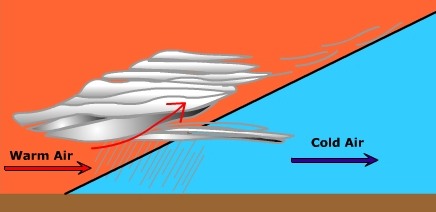
- Front
- boundaries between contrasting masses of air.
-
- Cold front
- where cold air replaces warm air.
-
- Warm front
- where warm air replaces cold air.
-
- Occluded front
- forms when a cold front catches up with a warm front.
-
- Stationary front
- where no change in air masses or movement of the front occurs.
-
- Quasi-stationary front
- found migrating within a particular latitudinal zone throughout most of the year.
-
- Polar front
- the boundary between polar-type air and tropical-type air.
-
- Arctic front
- the boundary between cold arctic air mass and the warmer air of the polar cell.
-
- Warm front weather
-
Profile view of warm front
-
- Cold front weather
-

Profile of Cold Front
-
- Warm sector weather
- increase in the humidity of the air; "fair weather" clouds are often created by convection and instability in the warm and humid afternoon air. After a while the winds start to shift to the southwest and the humidity continues to rise.
-
- Cyclogenesis
- the development and intensification of a cyclone
-
- Initial Stage - Cyclogenesis
- opposing streams of air meet and create a cyclone shear
-
- Wave Stage- Cyclogenesis
- Once the air collides and cyclonic circulation commences, warm air from the south invades where cold air was once located north of the polar front. The developing system takes on the characteristic wave form
-
- Occluded Stage- Cyclogenesis
- Being more dense, the air behind the cold front can "bulldoze" the warmer and less dense air out of the way. The warm air rises off the surface and glides up and over the colder more dense air ahead of the warm front. there is less horizontal displacement and the warm front moves slower across the earth than does a cold front. Over time the cold front catches up with the warm front and the cyclone starts to occlude.
-
- Dissolving Stage- Cyclogenesis
- The system enters the dissolving stage after it occludes and the lifting mechanism is cutoff. Without the convergence and uplift, the cyclone dissipates in the atmosphere.
-
- Thunderstorm - Cumulus stage
- The initial stage of development. During this stage warm, moist, and unstable air is lifted from the surface. As the air ascends, it cools and upon reaching its dew point temperature begins to condense into a cumulus cloud. Near the end of this stage precipitation forms.
-
- Thunderstorm - Mature Stage
- The second stage - During the mature stage warm, moist updrafts continue to feed the thunderstorm while cold downdrafts begin to form. The downdrafts are a product of the entrainment of cool, dry air into the cloud by the falling rain. As rain falls through the air it drags the cool, dry air that surrounds the cloud into it. As dry air comes in contact with cloud and rain droplets they evaporate cooling the cloud. The falling rain drags this cool air to the surface as a cold downdraft.
-
- Thunderstorm - Dissipating Stage
- The final stage - the thunderstorm dissolves away. By this point, the entrainment of cool air into the cloud helps stabilize the air. In the case of the air mass thunderstorm, the surface no longer provides enough convective uplift to continue fueling the storm. As a result, the warm updrafts have ceased and only the cool downdrafts are present. The downdrafts end as the rain ceases and soon the thunderstorm dissipates.
-
- Lightning
- a massive discharge of electricity in response to a charge differential.
-
- Thunder
- a shockwave through the atmosphere caused by lightning
-
- Tornado
- an intense system of low pressure with violent updrafts and converging winds.
-
- Hurricane
- a large rotating cyclonic system born in the tropics.
-
- Storm Surge
- the high water level that accompanies a hurricane as it comes ashore.
Additional Resources
Focus on The Physical Environment: "Weather Forecasting through the Ages" (NASA Earth Observatory)
Connections: "Trees lost to Katrina May Present Climate Challenge" (NPR) 
Physical Geography Today: US National Weather Service - NOAA | US National Hurricane Center - NOAA
World of Change: Severe Storms (NASA Earth Observatory)
Multimedia
"Super Twisters" (National Geographic)
"Tracking Hurricanes" (PBS) The News Hour with Jim Lehrer Oct. 1, 2003 "For years, scientists have worked to develop powerful new tools to predict the paths of hurricanes and monitor their likely impact. Betty Ann Bowser reports on the latest technologies meteorologists are using to keep tabs on these devastating storms and what new tools are being developed."
"Hunting Killer Storms: Flying into the Eye of Isabel WGBH Forum Network Mish Michaels, meteorologist, WBZ-TV4 talks about her adventures chasing tornadoes, flying into hurricanes and trekking to Mt. Washington during the winter. (54:50)
"Tornado Sound " (NPR) Weekend Edition May 18, 2003 "Host Liane Hansen speaks with physicist Al Bedard, who studies the sounds of tornadoes at the Environmental Technology Laboratory of the National Oceanic and Atmospheric Administration.
"Looking at Hurricanes" (NASA/GSFC) Explore the "latest" technology for observing hurricanes.
["Storm that Drowned a City" from NOVA for an in depth look at Hurricane Katrina's impact on New Orleans, LA.]
Interactivities
- Realtime station model plotting and interpretation (WeatherWise)
Readings
![]() Tornadoes....Nature's Most Violent Storms
Tornadoes....Nature's Most Violent Storms
Visualization
![]() Weather Map Viewer (M. Ritter) - Current weather map slide show.
Weather Map Viewer (M. Ritter) - Current weather map slide show.
![]() "How hurricanes form" (CNN)
"How hurricanes form" (CNN)