
13.7: Water in the Desert
- Page ID
- 24978
\( \newcommand{\vecs}[1]{\overset { \scriptstyle \rightharpoonup} {\mathbf{#1}} } \)
\( \newcommand{\vecd}[1]{\overset{-\!-\!\rightharpoonup}{\vphantom{a}\smash {#1}}} \)
\( \newcommand{\dsum}{\displaystyle\sum\limits} \)
\( \newcommand{\dint}{\displaystyle\int\limits} \)
\( \newcommand{\dlim}{\displaystyle\lim\limits} \)
\( \newcommand{\id}{\mathrm{id}}\) \( \newcommand{\Span}{\mathrm{span}}\)
( \newcommand{\kernel}{\mathrm{null}\,}\) \( \newcommand{\range}{\mathrm{range}\,}\)
\( \newcommand{\RealPart}{\mathrm{Re}}\) \( \newcommand{\ImaginaryPart}{\mathrm{Im}}\)
\( \newcommand{\Argument}{\mathrm{Arg}}\) \( \newcommand{\norm}[1]{\| #1 \|}\)
\( \newcommand{\inner}[2]{\langle #1, #2 \rangle}\)
\( \newcommand{\Span}{\mathrm{span}}\)
\( \newcommand{\id}{\mathrm{id}}\)
\( \newcommand{\Span}{\mathrm{span}}\)
\( \newcommand{\kernel}{\mathrm{null}\,}\)
\( \newcommand{\range}{\mathrm{range}\,}\)
\( \newcommand{\RealPart}{\mathrm{Re}}\)
\( \newcommand{\ImaginaryPart}{\mathrm{Im}}\)
\( \newcommand{\Argument}{\mathrm{Arg}}\)
\( \newcommand{\norm}[1]{\| #1 \|}\)
\( \newcommand{\inner}[2]{\langle #1, #2 \rangle}\)
\( \newcommand{\Span}{\mathrm{span}}\) \( \newcommand{\AA}{\unicode[.8,0]{x212B}}\)
\( \newcommand{\vectorA}[1]{\vec{#1}} % arrow\)
\( \newcommand{\vectorAt}[1]{\vec{\text{#1}}} % arrow\)
\( \newcommand{\vectorB}[1]{\overset { \scriptstyle \rightharpoonup} {\mathbf{#1}} } \)
\( \newcommand{\vectorC}[1]{\textbf{#1}} \)
\( \newcommand{\vectorD}[1]{\overrightarrow{#1}} \)
\( \newcommand{\vectorDt}[1]{\overrightarrow{\text{#1}}} \)
\( \newcommand{\vectE}[1]{\overset{-\!-\!\rightharpoonup}{\vphantom{a}\smash{\mathbf {#1}}}} \)
\( \newcommand{\vecs}[1]{\overset { \scriptstyle \rightharpoonup} {\mathbf{#1}} } \)
\(\newcommand{\longvect}{\overrightarrow}\)
\( \newcommand{\vecd}[1]{\overset{-\!-\!\rightharpoonup}{\vphantom{a}\smash {#1}}} \)
\(\newcommand{\avec}{\mathbf a}\) \(\newcommand{\bvec}{\mathbf b}\) \(\newcommand{\cvec}{\mathbf c}\) \(\newcommand{\dvec}{\mathbf d}\) \(\newcommand{\dtil}{\widetilde{\mathbf d}}\) \(\newcommand{\evec}{\mathbf e}\) \(\newcommand{\fvec}{\mathbf f}\) \(\newcommand{\nvec}{\mathbf n}\) \(\newcommand{\pvec}{\mathbf p}\) \(\newcommand{\qvec}{\mathbf q}\) \(\newcommand{\svec}{\mathbf s}\) \(\newcommand{\tvec}{\mathbf t}\) \(\newcommand{\uvec}{\mathbf u}\) \(\newcommand{\vvec}{\mathbf v}\) \(\newcommand{\wvec}{\mathbf w}\) \(\newcommand{\xvec}{\mathbf x}\) \(\newcommand{\yvec}{\mathbf y}\) \(\newcommand{\zvec}{\mathbf z}\) \(\newcommand{\rvec}{\mathbf r}\) \(\newcommand{\mvec}{\mathbf m}\) \(\newcommand{\zerovec}{\mathbf 0}\) \(\newcommand{\onevec}{\mathbf 1}\) \(\newcommand{\real}{\mathbb R}\) \(\newcommand{\twovec}[2]{\left[\begin{array}{r}#1 \\ #2 \end{array}\right]}\) \(\newcommand{\ctwovec}[2]{\left[\begin{array}{c}#1 \\ #2 \end{array}\right]}\) \(\newcommand{\threevec}[3]{\left[\begin{array}{r}#1 \\ #2 \\ #3 \end{array}\right]}\) \(\newcommand{\cthreevec}[3]{\left[\begin{array}{c}#1 \\ #2 \\ #3 \end{array}\right]}\) \(\newcommand{\fourvec}[4]{\left[\begin{array}{r}#1 \\ #2 \\ #3 \\ #4 \end{array}\right]}\) \(\newcommand{\cfourvec}[4]{\left[\begin{array}{c}#1 \\ #2 \\ #3 \\ #4 \end{array}\right]}\) \(\newcommand{\fivevec}[5]{\left[\begin{array}{r}#1 \\ #2 \\ #3 \\ #4 \\ #5 \\ \end{array}\right]}\) \(\newcommand{\cfivevec}[5]{\left[\begin{array}{c}#1 \\ #2 \\ #3 \\ #4 \\ #5 \\ \end{array}\right]}\) \(\newcommand{\mattwo}[4]{\left[\begin{array}{rr}#1 \amp #2 \\ #3 \amp #4 \\ \end{array}\right]}\) \(\newcommand{\laspan}[1]{\text{Span}\{#1\}}\) \(\newcommand{\bcal}{\cal B}\) \(\newcommand{\ccal}{\cal C}\) \(\newcommand{\scal}{\cal S}\) \(\newcommand{\wcal}{\cal W}\) \(\newcommand{\ecal}{\cal E}\) \(\newcommand{\coords}[2]{\left\{#1\right\}_{#2}}\) \(\newcommand{\gray}[1]{\color{gray}{#1}}\) \(\newcommand{\lgray}[1]{\color{lightgray}{#1}}\) \(\newcommand{\rank}{\operatorname{rank}}\) \(\newcommand{\row}{\text{Row}}\) \(\newcommand{\col}{\text{Col}}\) \(\renewcommand{\row}{\text{Row}}\) \(\newcommand{\nul}{\text{Nul}}\) \(\newcommand{\var}{\text{Var}}\) \(\newcommand{\corr}{\text{corr}}\) \(\newcommand{\len}[1]{\left|#1\right|}\) \(\newcommand{\bbar}{\overline{\bvec}}\) \(\newcommand{\bhat}{\widehat{\bvec}}\) \(\newcommand{\bperp}{\bvec^\perp}\) \(\newcommand{\xhat}{\widehat{\xvec}}\) \(\newcommand{\vhat}{\widehat{\vvec}}\) \(\newcommand{\uhat}{\widehat{\uvec}}\) \(\newcommand{\what}{\widehat{\wvec}}\) \(\newcommand{\Sighat}{\widehat{\Sigma}}\) \(\newcommand{\lt}{<}\) \(\newcommand{\gt}{>}\) \(\newcommand{\amp}{&}\) \(\definecolor{fillinmathshade}{gray}{0.9}\)Water Shapes the Landscape
While deserts are defined as arid regions, there is still abundant evidence of water in the landscape. Although rain does not fall often, rains can be quite heavy when they do fall, causing intense flash flooding. Thus, water is an important element in shaping the landscape. To read more about water in California, see California's Water. Another chapter, California's Climate, contains helpful information about past climate since it can impact the amount of available water in a particular region.
Playas and Ephemeral Rivers
There are areas within deserts that form enclosed basins, zones where streams enter, but none drain out. The water in these enclosed basins is removed by evaporation and a dry lake bed is formed called a playa.
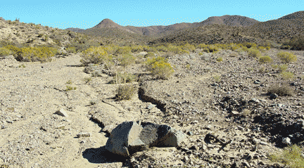
Playas are among the flattest of all landforms. Such a dry lake bed may cover a large area and be filled after a heavy thunderstorm to only a few inches deep. They may preserve evidence of seasonal water by way of mud cracks (Figure \(\PageIndex{1}\)) or salt deposits.

Playa lakes and desert streams that contain water only after rainstorms are called intermittent or ephemeral. Because of intense thunderstorms, the volume of water transported by ephemeral drainage in arid environments can be substantial during a short period of time. Desert soil structures lack organic matter that promotes infiltration by absorbing water. Instead of percolating into the soil, the runoff compacts the ground surface, making the soil hydrophobic or water-repellant. Because of this hardpan surface, ephemeral streams may gather water across large areas, suddenly filling with water from storms many miles away.
High-volume ephemeral flows, called flash floods, may move as sheet flows or sheet wash, as well as be channeled through normally dry arroyos or canyons. Flash floods are similar to debris flows in that they are a major factor in desert deposition. Dry channels can fill quickly with ephemeral drainage, creating a mass of water and debris that charges down the arroyo, and even overflowing the banks (Figure \(\PageIndex{2}\)). Flash floods pose a serious hazard for desert travelers because the storm activity feeding the runoff may be miles away. People hiking or camping in arroyos that have been bone dry for months, or years, have been swept away by sudden flash floods.
The Mojave River
The Mojave River is the largest drainage system in the Mojave Desert. Its modern extent and capacity is only a fraction compared to its extent during the Last Glacial Maximum. At its peak during this last ice age, the Mojave River drainage basin extended from the San Bernardino Mountains in the west; it flowed east and north ultimately merging with the Amargosa River before draining into Lake Manley in Death Valley. At this peak period, waters of the Mojave River drainage system flowed through, or contributed water to, several great Pleistocene Lakes: Lake Manix (which incorporated modern dry lake basins Afton, Troy, Coyote, Harper, and Cronese basins), and Lake Mojave (including dry Soda Lake and dry Silver Lake basins). Today Soda Lake is the current terminal point of the Mojave River (although it has flowed into Silver Lake in historic times) (Figure \(\PageIndex{3}\)).

This silent video tracks the path of the Mojave River using remote sensing data that is draped over a digital elevation model. It is described below.
The animation opens with an aerial view of western San Bernardino County, California. The map displays county boundaries, cities, seven dry lakes, and intermittent and perennial streams. The map then zooms into the length of the Mojave River channel. The Mojave River is the largest of the streams and rivers that flow through the area and extends more than 100 miles east from its source in the San Bernardino Mountains to the end east of Afton Canyon (Thompson, 1929; Lines, 1996). Next, locations of points of interest appear on the map, including Mojave Forks Dam, Mojave Water Agency, Upper Narrows, Lower Narrows, and Afton Canyon. The floodplain aquifer boundary is then displayed, as is the surface water and groundwater monitoring sites in the area. The cities, dry lakes, points of interest, the river channel, and the monitoring sites remain visible for the duration of the river tour. The fly-through tour then begins, providing a 3D topographic view of the entire river channel length, which is dry for the entire length. The animation begins at the junction of Deep Creek and West Fork Mojave River at Mojave River Forks Reservoir located at the northern foot of the San Bernardino Mountains at an elevation of about 3,000 feet above sea level. From the reservoir, the river generally flows northward through the city of Victorville. The animation slows down as it approaches and travels through the Upper and Lower Narrows (small canyons). The tour continues generally north and northeastward through the city of Barstow and, eventually through Afton Canyon. After emerging from Afton Canyon, the river splits into separate channels leading to East Cronise Lake and Soda Lake.
Videographer: Sally House USGS California Water Science Center shouse@usgs.gov
This drainage system evolved along with the changing landscape beginning in late Tertiary time when tectonic uplift of mountain ranges around the Mojave region and changes in regional climatic conditions were occurring at the same time. The modern river system began developing as westward-flowing stream drainages were blocked by the uplift of the Transverse Ranges along the greater San Andreas Fault System. The combination of blocked drainage systems and increased precipitation with the onset of cooler or ice age conditions at the close of the Tertiary resulted in the filling of basins with water (and sediments). Progressively through the latest Tertiary and into the Quaternary periods, lakes filled and streams overflowed through low divides between ranges and flooded adjacent basins. In this manner, the Mojave River evolved from the spilling over of lakes in the western Mojave Desert region. These large lakes do not exist today. Two large lakes that played a significant role in the development of the landscape in the Mojave National Preserve area were Lake Manix and Lake Mojave. Sediments associated with these ancient lake deposits (and others in the region) record a story of climate change in the region (Figure \(\PageIndex{4}\)).

Lake Manix (Figure \(\PageIndex{3}\)) was a large inland lake that was located in the Barstow, CA region and Lake Mojave was in the Baker, CA region; there are many remnants of these larger features that persist today. The development of these lakes and other lakes in the region was progressive with time, with Manix Lake filling first, and Lake Mojave forming later when the Lake Manix filled to capacity and spilled westward, ultimately carving Afton Canyon during the last glacial maximum about 18,000 years ago.
The Salton Sea
The Salton Sea is California’s largest lake (Figure \(\PageIndex{5}\)). It was formed by accident in the early 1900s, when water diverted from the Colorado River broke through canal gates and filled the low-lying basin—continuing a long history of drying and filling. Today, the lake is fed primarily by the runoff from farm irrigation, and to a lesser extent from urban runoff, groundwater and rainfall. This lake has no natural outlet, so water must evaporate to leave the system; this makes it saltier than the ocean.
The sea occupies a transtensional rift valley called the Salton Trough. Home to important agricultural areas, this rift valley graben reflects the combined effects of the San Andreas fault and the northern limits of the East Pacific Rise.

This area has become an environmental problem, with periodic episodes of fish-die offs and an ongoing odor of decay. On the other hand, brines derived from this sea may ultimately be a valuable source of lithium.
References
- Dohrenwend, J. C. (2007). Tertiary and Quaternary Deposits. In Geology and Mineral Resources of the East Mojave National Scenic Area, San Bernardino County, California (pp. 73-75). USGS.
- Geology of Joshua Tree National Park | U.S. Geological Survey. (n.d.). USGS.gov. Retrieved September 3, 2023, from https://www.usgs.gov/geology-and-ecology-of-national-parks/geology-joshua-tree-national-park
- Harden, D. R. (2004). California Geology. Pearson Prentice Hall.
- Lines, G.C., 1996, Ground-water and surface-water relations along the Mojave River, Southern California: U.S. Geological Survey Water-Resources Investigations Report 95-4189, 43 p., https://doi.org/10.3133/wri954189.
- Natural History of the Granite Mountains. (n.d.). Sweeney Granite Mountains. Retrieved September 2, 2023, from https://granite.ucnrs.org/natural-history-of-the-granite-mountains/
- Our Dynamic Desert. (2009, December 18). Our Dynamic Desert. Retrieved August 31, 2023, from https://pubs.usgs.gov/of/2004/1007/intro.html
- Reheis, M. C., Miller, D. M., Paces, J. B., Oviatt, C. G., Redwine, J. R., Kaufman, D., Bright, J., & Wan, E. (2021). Geomorphic history of Lake Manix, Mojave Desert, California: Evolution of a complex terminal lake basin. Elsevier. https://doi.org/10.1016/j.geomorph.2021.107901
- Thompson, D. (1929). The Mojave Desert Region, California. a Geographic, Geologic, and Hydrologic Reconnaissance. Department of the Interior.
- Walker, A. S. (1996). Deserts: Geology and Resources. USGS.