
8.3.1.3: Salmon Creek Beach
- Page ID
- 708

\( \newcommand{\vecs}[1]{\overset { \scriptstyle \rightharpoonup} {\mathbf{#1}} } \)
\( \newcommand{\vecd}[1]{\overset{-\!-\!\rightharpoonup}{\vphantom{a}\smash {#1}}} \)
\( \newcommand{\dsum}{\displaystyle\sum\limits} \)
\( \newcommand{\dint}{\displaystyle\int\limits} \)
\( \newcommand{\dlim}{\displaystyle\lim\limits} \)
\( \newcommand{\id}{\mathrm{id}}\) \( \newcommand{\Span}{\mathrm{span}}\)
( \newcommand{\kernel}{\mathrm{null}\,}\) \( \newcommand{\range}{\mathrm{range}\,}\)
\( \newcommand{\RealPart}{\mathrm{Re}}\) \( \newcommand{\ImaginaryPart}{\mathrm{Im}}\)
\( \newcommand{\Argument}{\mathrm{Arg}}\) \( \newcommand{\norm}[1]{\| #1 \|}\)
\( \newcommand{\inner}[2]{\langle #1, #2 \rangle}\)
\( \newcommand{\Span}{\mathrm{span}}\)
\( \newcommand{\id}{\mathrm{id}}\)
\( \newcommand{\Span}{\mathrm{span}}\)
\( \newcommand{\kernel}{\mathrm{null}\,}\)
\( \newcommand{\range}{\mathrm{range}\,}\)
\( \newcommand{\RealPart}{\mathrm{Re}}\)
\( \newcommand{\ImaginaryPart}{\mathrm{Im}}\)
\( \newcommand{\Argument}{\mathrm{Arg}}\)
\( \newcommand{\norm}[1]{\| #1 \|}\)
\( \newcommand{\inner}[2]{\langle #1, #2 \rangle}\)
\( \newcommand{\Span}{\mathrm{span}}\) \( \newcommand{\AA}{\unicode[.8,0]{x212B}}\)
\( \newcommand{\vectorA}[1]{\vec{#1}} % arrow\)
\( \newcommand{\vectorAt}[1]{\vec{\text{#1}}} % arrow\)
\( \newcommand{\vectorB}[1]{\overset { \scriptstyle \rightharpoonup} {\mathbf{#1}} } \)
\( \newcommand{\vectorC}[1]{\textbf{#1}} \)
\( \newcommand{\vectorD}[1]{\overrightarrow{#1}} \)
\( \newcommand{\vectorDt}[1]{\overrightarrow{\text{#1}}} \)
\( \newcommand{\vectE}[1]{\overset{-\!-\!\rightharpoonup}{\vphantom{a}\smash{\mathbf {#1}}}} \)
\( \newcommand{\vecs}[1]{\overset { \scriptstyle \rightharpoonup} {\mathbf{#1}} } \)
\(\newcommand{\longvect}{\overrightarrow}\)
\( \newcommand{\vecd}[1]{\overset{-\!-\!\rightharpoonup}{\vphantom{a}\smash {#1}}} \)
\(\newcommand{\avec}{\mathbf a}\) \(\newcommand{\bvec}{\mathbf b}\) \(\newcommand{\cvec}{\mathbf c}\) \(\newcommand{\dvec}{\mathbf d}\) \(\newcommand{\dtil}{\widetilde{\mathbf d}}\) \(\newcommand{\evec}{\mathbf e}\) \(\newcommand{\fvec}{\mathbf f}\) \(\newcommand{\nvec}{\mathbf n}\) \(\newcommand{\pvec}{\mathbf p}\) \(\newcommand{\qvec}{\mathbf q}\) \(\newcommand{\svec}{\mathbf s}\) \(\newcommand{\tvec}{\mathbf t}\) \(\newcommand{\uvec}{\mathbf u}\) \(\newcommand{\vvec}{\mathbf v}\) \(\newcommand{\wvec}{\mathbf w}\) \(\newcommand{\xvec}{\mathbf x}\) \(\newcommand{\yvec}{\mathbf y}\) \(\newcommand{\zvec}{\mathbf z}\) \(\newcommand{\rvec}{\mathbf r}\) \(\newcommand{\mvec}{\mathbf m}\) \(\newcommand{\zerovec}{\mathbf 0}\) \(\newcommand{\onevec}{\mathbf 1}\) \(\newcommand{\real}{\mathbb R}\) \(\newcommand{\twovec}[2]{\left[\begin{array}{r}#1 \\ #2 \end{array}\right]}\) \(\newcommand{\ctwovec}[2]{\left[\begin{array}{c}#1 \\ #2 \end{array}\right]}\) \(\newcommand{\threevec}[3]{\left[\begin{array}{r}#1 \\ #2 \\ #3 \end{array}\right]}\) \(\newcommand{\cthreevec}[3]{\left[\begin{array}{c}#1 \\ #2 \\ #3 \end{array}\right]}\) \(\newcommand{\fourvec}[4]{\left[\begin{array}{r}#1 \\ #2 \\ #3 \\ #4 \end{array}\right]}\) \(\newcommand{\cfourvec}[4]{\left[\begin{array}{c}#1 \\ #2 \\ #3 \\ #4 \end{array}\right]}\) \(\newcommand{\fivevec}[5]{\left[\begin{array}{r}#1 \\ #2 \\ #3 \\ #4 \\ #5 \\ \end{array}\right]}\) \(\newcommand{\cfivevec}[5]{\left[\begin{array}{c}#1 \\ #2 \\ #3 \\ #4 \\ #5 \\ \end{array}\right]}\) \(\newcommand{\mattwo}[4]{\left[\begin{array}{rr}#1 \amp #2 \\ #3 \amp #4 \\ \end{array}\right]}\) \(\newcommand{\laspan}[1]{\text{Span}\{#1\}}\) \(\newcommand{\bcal}{\cal B}\) \(\newcommand{\ccal}{\cal C}\) \(\newcommand{\scal}{\cal S}\) \(\newcommand{\wcal}{\cal W}\) \(\newcommand{\ecal}{\cal E}\) \(\newcommand{\coords}[2]{\left\{#1\right\}_{#2}}\) \(\newcommand{\gray}[1]{\color{gray}{#1}}\) \(\newcommand{\lgray}[1]{\color{lightgray}{#1}}\) \(\newcommand{\rank}{\operatorname{rank}}\) \(\newcommand{\row}{\text{Row}}\) \(\newcommand{\col}{\text{Col}}\) \(\renewcommand{\row}{\text{Row}}\) \(\newcommand{\nul}{\text{Nul}}\) \(\newcommand{\var}{\text{Var}}\) \(\newcommand{\corr}{\text{corr}}\) \(\newcommand{\len}[1]{\left|#1\right|}\) \(\newcommand{\bbar}{\overline{\bvec}}\) \(\newcommand{\bhat}{\widehat{\bvec}}\) \(\newcommand{\bperp}{\bvec^\perp}\) \(\newcommand{\xhat}{\widehat{\xvec}}\) \(\newcommand{\vhat}{\widehat{\vvec}}\) \(\newcommand{\uhat}{\widehat{\uvec}}\) \(\newcommand{\what}{\widehat{\wvec}}\) \(\newcommand{\Sighat}{\widehat{\Sigma}}\) \(\newcommand{\lt}{<}\) \(\newcommand{\gt}{>}\) \(\newcommand{\amp}{&}\) \(\definecolor{fillinmathshade}{gray}{0.9}\)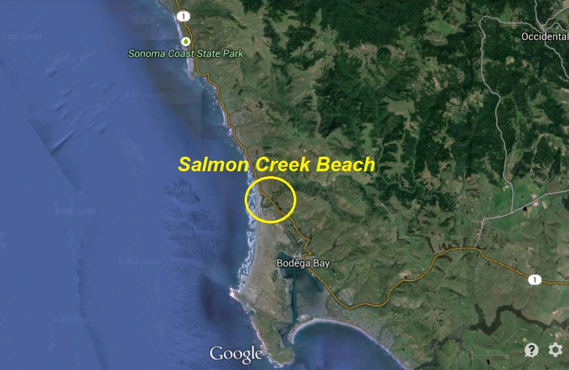
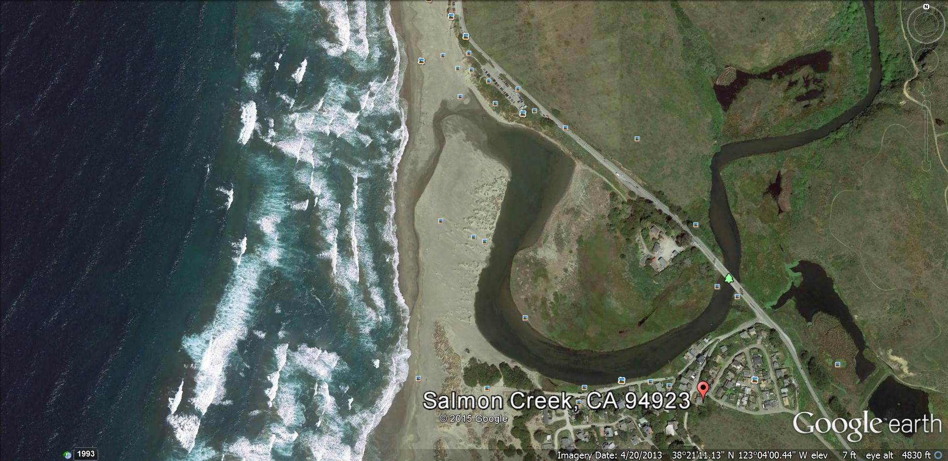
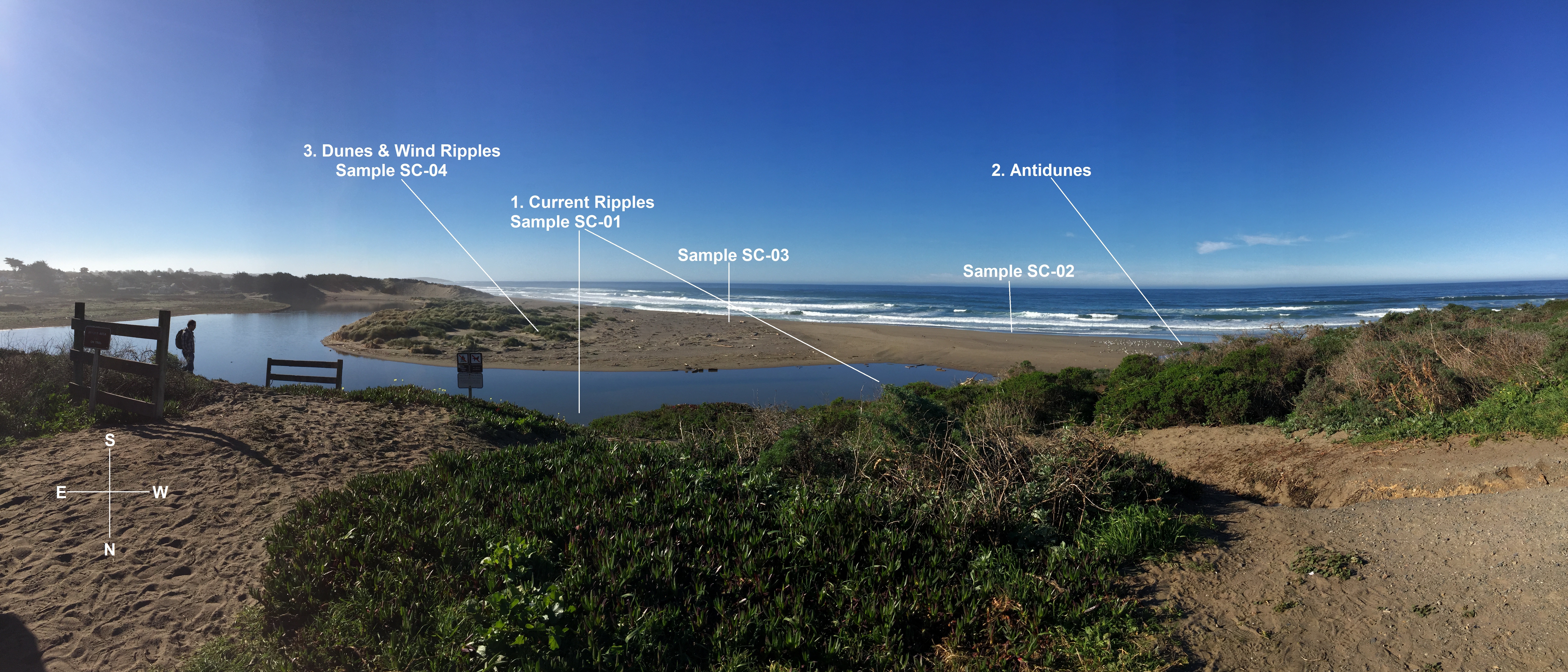
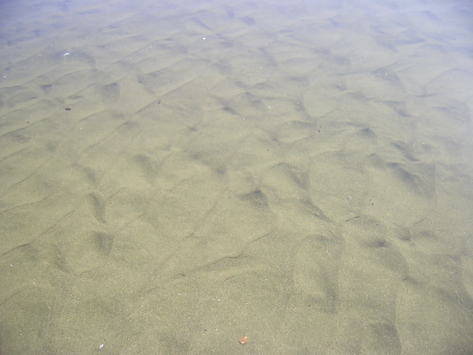
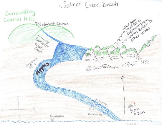
Welcome to Salmon Creek Beach located in beautiful Sonoma County, California! This site was visited, along with several others in Bodega Bay, on January 31, 2015 in order to observe active sedimentary processes and to document spacial trends in sediments within an environmental context. Salmon Creek Beach consists of an estuary that is fed by Salmon creek that originates from the surrounding coastal hills and empties into the Pacific Ocean. Depending on the time of the year and the meteorological conditions, the estuary may or may not fully reach the ocean; however, on the day the site was visited, the Pacific Ocean and Salmon creek were connected. Looking at the left, southern side of the above image, the back of the estuary is lined with dunes and is a very low-energy environment where flow velocities are very low. In the images below, we see an increase in energy and flow velocity as water moves through a smaller, narrower area and bends around to where it meets with the Pacific Ocean. We can also see the cut bank of where the channel water level used to be at higher tides as it meanders on the beach toward the ocean. The most prominent sedimentary structures that were observed at Salmon Creek Beach were current ripples, antidunes, dunes, and wind ripples, along with the bioturbation (human and wildlife footprints).
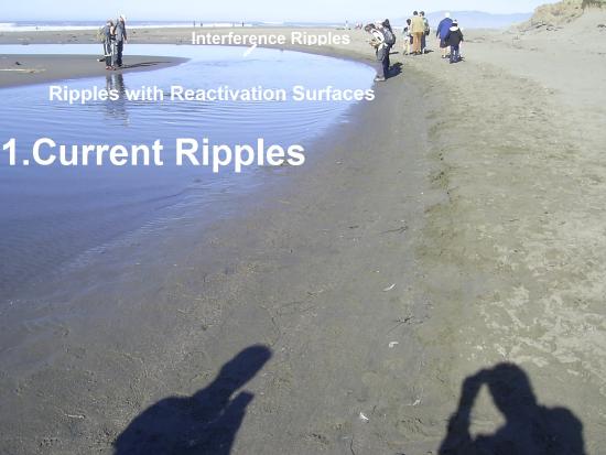
1. Current Ripples
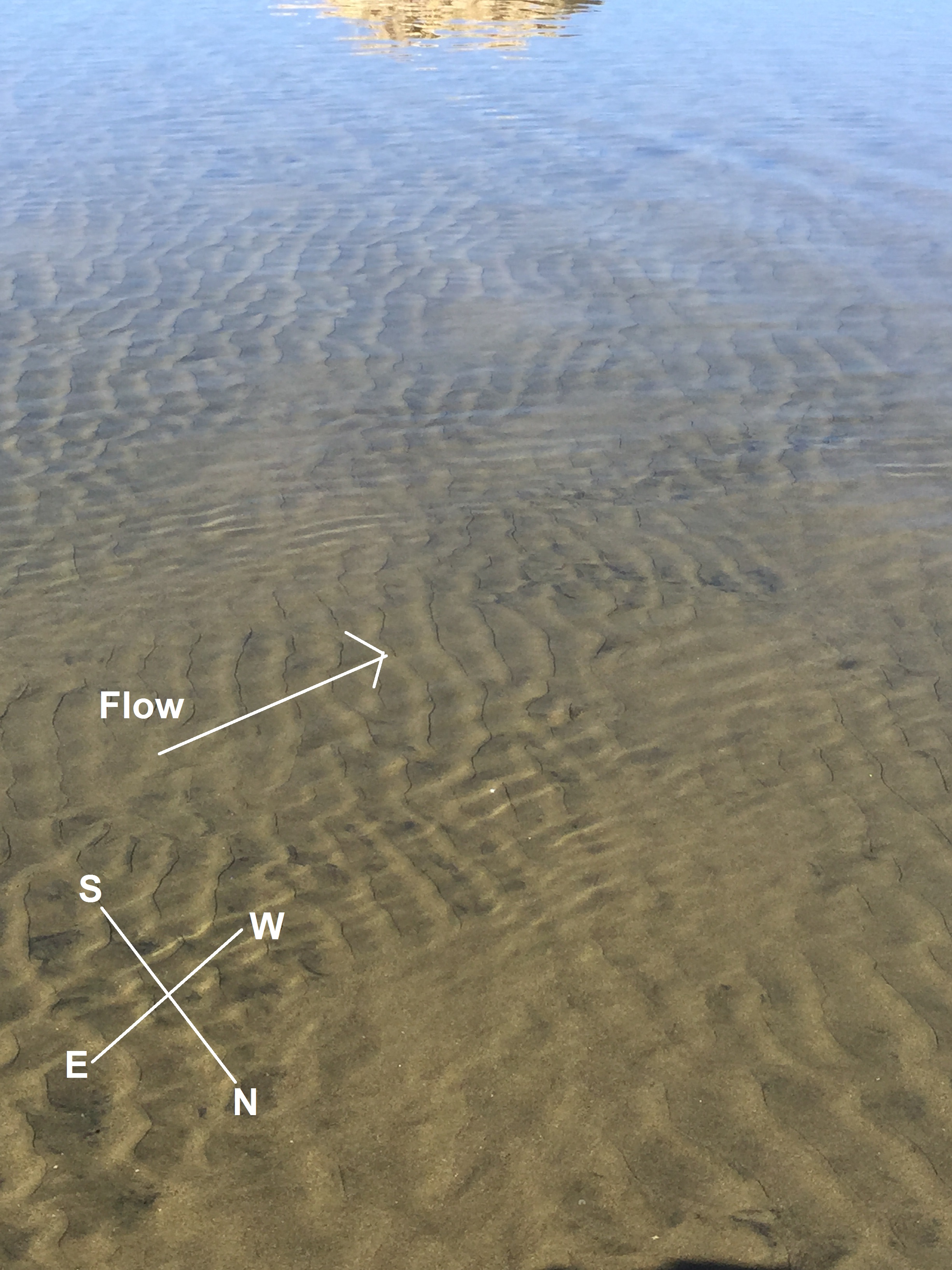
The first observed sedimentary structures were current ripples. These type of ripples indicate present unidirectional flow moment, which was initially determined to be north and then west closer to the bed of the ocean. The direction of the ripples changed where the flows of Salmon creek and the Pacific Ocean began to meet. The flow direction can be concluded by the direction of the Lee side, or grain attachment point. This side is where the grains being transported go from being suspended in the flow to depositing "down" to the bed again. The process of lamination is where such grains begin to repeat the process and produce wavy surface features known as ripples. The ripples seen at the beginning of Salmon creek, bottom images,were in between sinuous and linear and were measured to have a wavelength (from crest to crest) of 30mm with a flow direction going north. This small wavelength was suggestive of calm flow speeds, allowing fine sediment to be deposited.


(penny for scale) (footprint for scale)
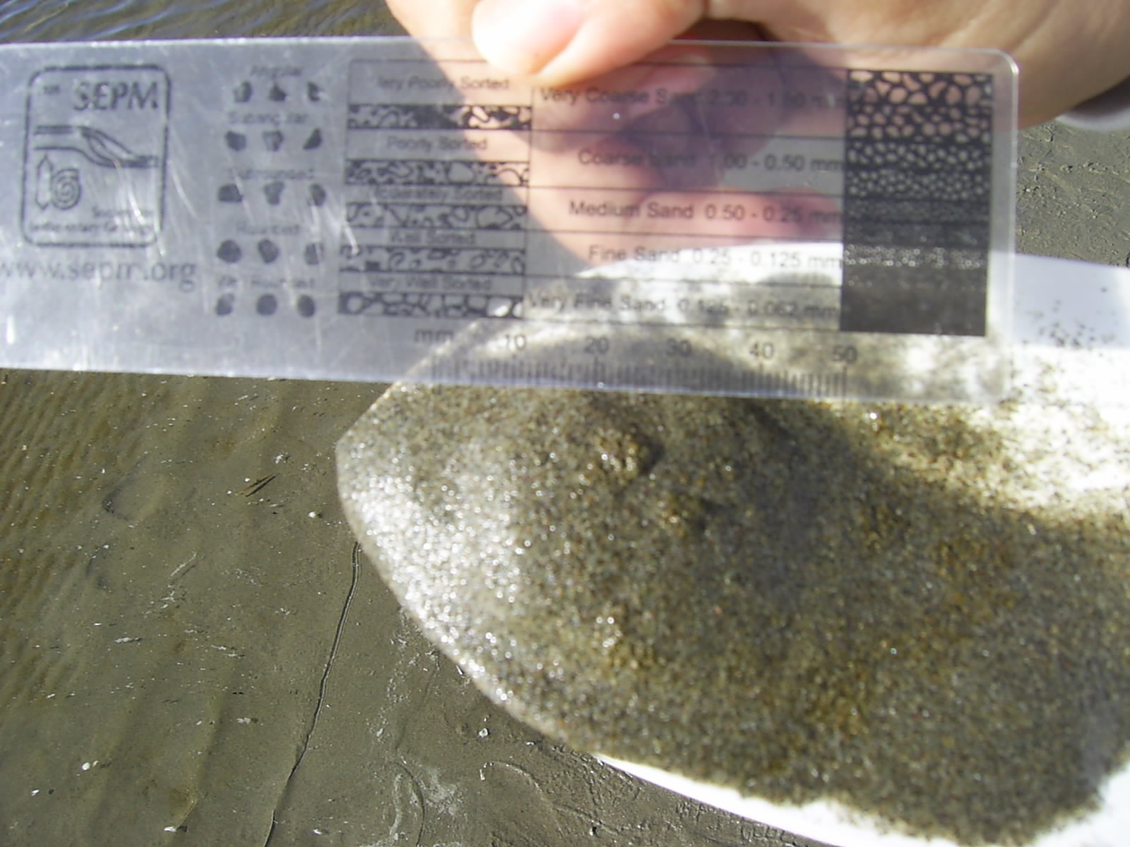
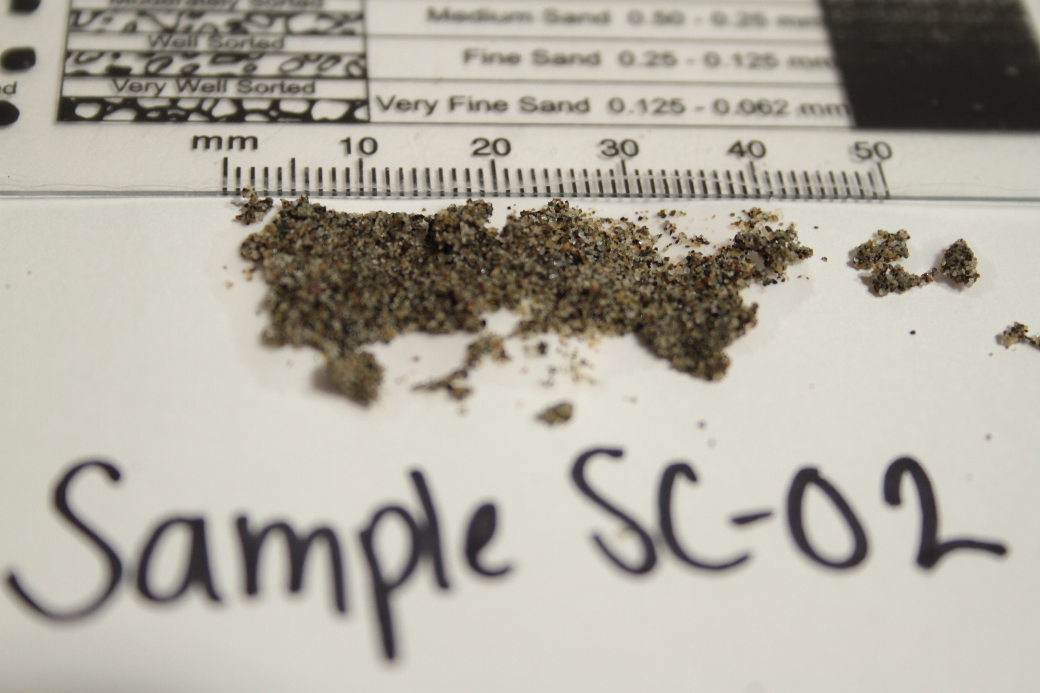
Sample SC-01 was collected here and was later analyzed. The sample contains well-sorted very fine to fine sand consisting of quartz, lithics, and occasional pieces of glass and shells. The sediments here overall are well-rounded to rounded and spheroidal which suggests the grains are texturally and compositionally mature, meaning they are far away from the source of sediments.
(Sample SC-01)
Closer to the ocean as the channel meanders, ripples are still observed however they change in magnitude and direction. Given the flow is directed towards the ocean, the ripples change to that direction (west), bottom left. As the channel nears the ocean, ripple wavelengths were observed to get longer and sand grains became coarser. Wavelengths were now measured to be up to 90mm, consisting of the same sediments. These sediments were coarser and didn't share the uniform spherocity of the grains up the creek. The reason for this change in ripple characteristics was a result of flow differences. The flow had increased here and was able to carry more coarse sediments. The changes in flow allowed for the formation of reactivation surfaces, bottom right.
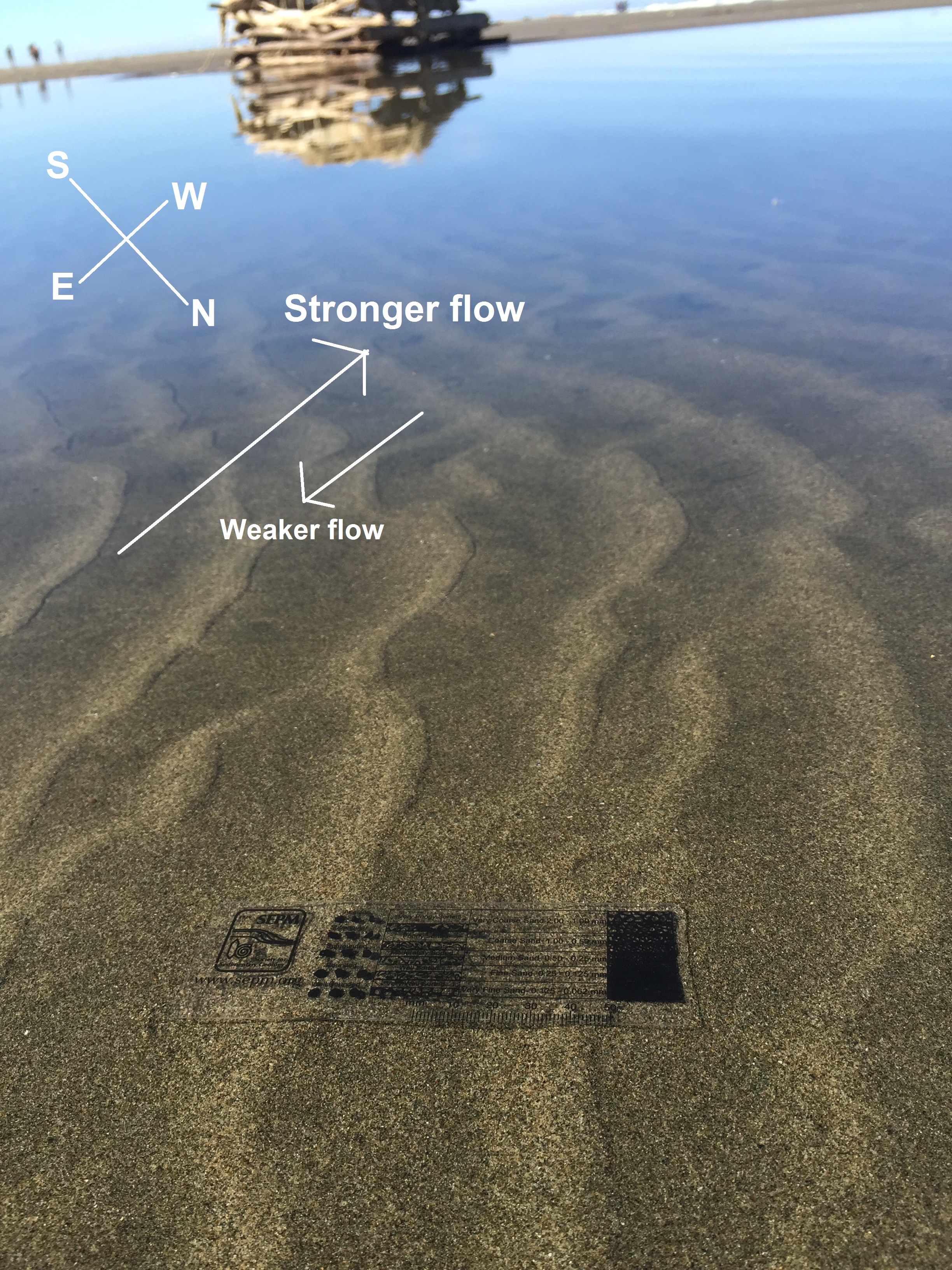
Reactivation surfaces occur from bidirectional flow where a one flow direction dominates and creates the ripple structure while an opposing weaker flow erodes the top of the ripple.
Aside from the current ripples observed, an area by the bend of the channel had interference ripples. Unlike the unidirectional ripples formed by current flow, these ripples indicate bidirectional flow. This means that at some point in tide fluctuations there were two different flow directions. These directions were from the creek to the ocean and from the ocean to the creek, or east to west. Indicative features of interference ripples are visible in the picture below, where sinuous ripples cross one another.
(penny for scale)
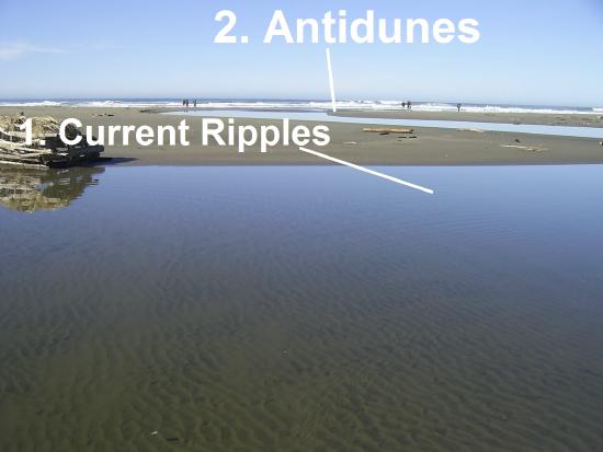
2. Antidunes
Along the stream connecting the lagoon and the ocean was observable a sedimentary bedform recognized as antidunes. These formations are possible when Froude’s number of a flow is close to one so standing waves may form on the surface of the water before steepening and breaking in an upstream direction. As a result, the sand on the bed develops a bedform surface parallel to the standing wave; therefore, as the flow steepens, sediment accumulates on the upstream side of the bedform creating these unique structures. In the video recorded at Salmon Creek, we find that the fluvial environment present has the flow velocity needed to form the antidunes.
Video taken at Salmon Creek Beach showing the antidunes that formed in the shallow stream with a high flow rate.
Further down from where the antidunes were seen where the channel meets the swash zone, Sample SC-02 was taken. Sample SC-02 was analyzed to be coarser than SC-01 and consisted of well-sorted fine to medium sands primarily composed of quartz and lithics. Sediments in the swash zone are exposed to medium energy processes which gives us the medium sized grains as opposed to those finer grains found in the breaker and surf zone. The main sedimentary structures associated with Sample SC-02 would be bioturbation and faint lines of longshore drift.
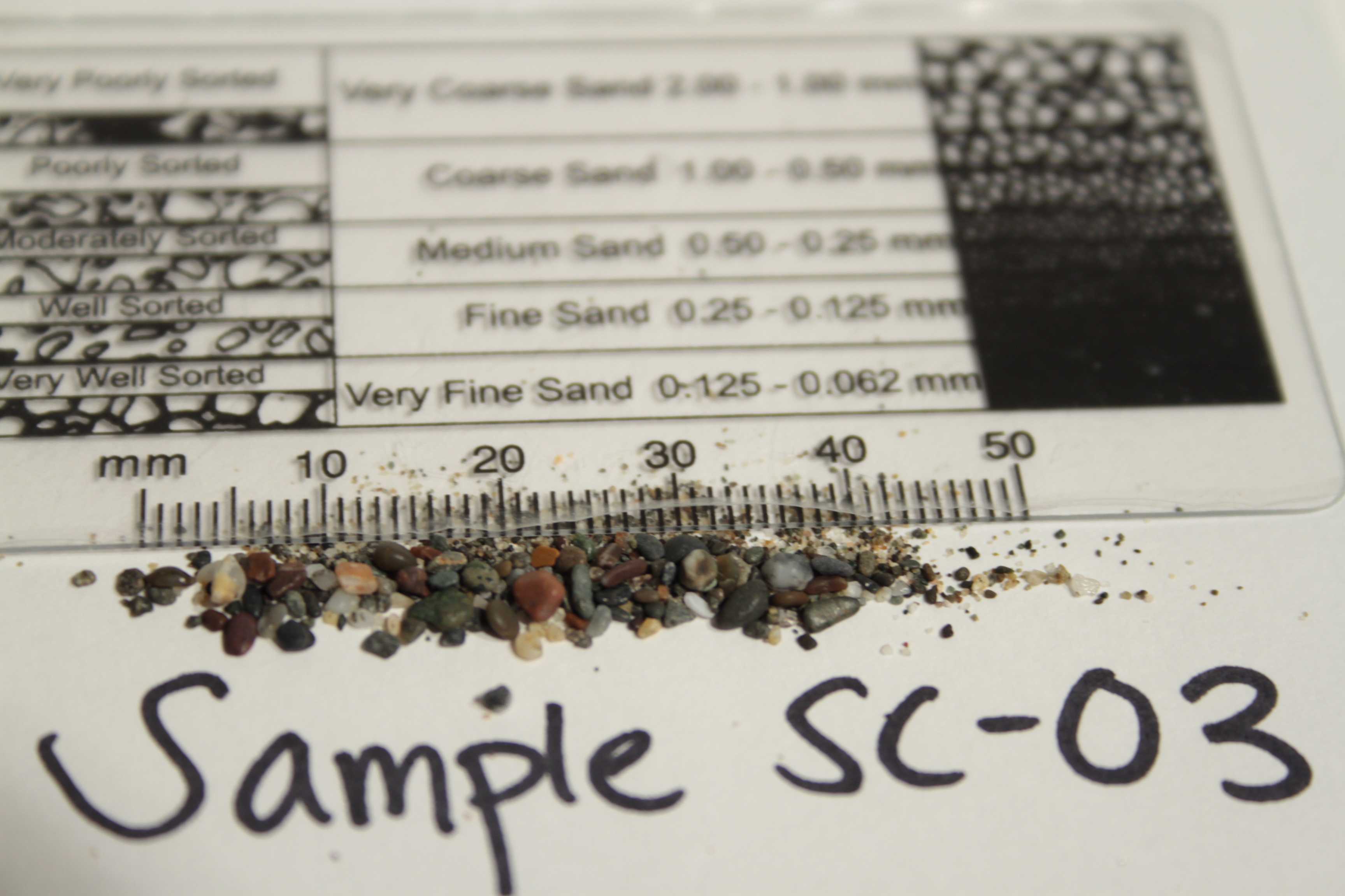
Sample SC-03 was collected about halfway towards the dunes (going east) from the swash zone of the ocean past the antidunes. (See pictures at top of page for exact location). This sample contains moderately-sorted very fine sand to granule-sized grains that are composed of quartz, lithics, and shells. In this area, bioturbation as well as ripples were observed in the area. Coarser grains were concentrated on top of finer grains.
3. Aeolian Dunes and Ripples
Other sedimentary structures present were dunes and wind ripples. Dunes, also recognized as “megaripples,” are bedforms distinctly larger than ripples. These bedforms are usually known as hills of sand that are produced by either water flow or wind. Dunes vary in size and are formed as sediments are pushed up the stoss side and are deposited on the lee side. At Salmon Creek Beach, we find that the dunes are primarily shaped by wind activity and are primarily comprised of the very fine-grained sediments transported and deposited by wind. These Aeolian dunesraneg from about 3 meters to 600 meters in wavelength and are between 10 cm and 100 meters high. Again, the migration of sediments, saltation, up the stoss side to the crest form structures like Aeolian ripples.

Aeolian Ripples are formed as grains migrate across a bed of sand creating patches of piled up grains. These “piles” of grains are due to irregularities on the surface of the sand that then pile in a perpendicular fashion equally spaced apart; therefore, the crests formed produce these aeolian ripples comprised of very fine to medium sized grains. The direction of these ripples are dependent on the direction of the wind which carries different sized grains depending on the strength of the blowing wind. The coarser grains in any given wind current are concentrated on the crests where the finer grains continue being transported by the wind. As the crests develop, the grains avalanche down the lee side into the rough forming cross-laminations.
In the figure above, we can notice the aeolian ripples formed by the wind blowing in the southward direction. Each ripple is equally spaced out and is comprised, more or less, of the same fine sized grains.
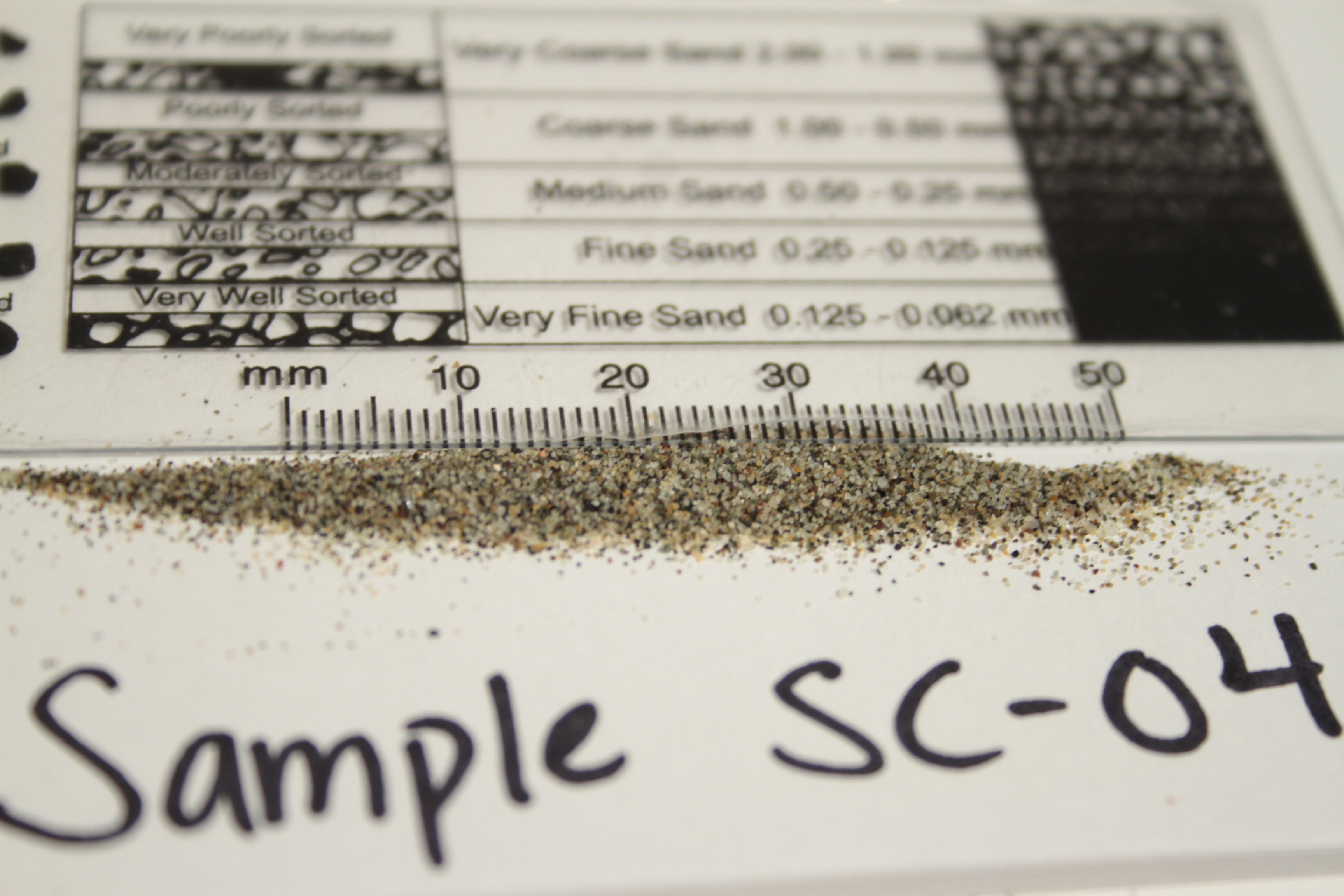
Sample SC-04 was collected in this area and is consisted of well-sorted medium to very-fine quartz and lithic sands. The sedimentary structures associated with this sample are bioturbation (human and animal footprints), wind ripples, and dunes.
Interpretation
This coastal location has experienced an immense amount of sediment allocation from different sources. Methods including air and water have deposited the sediments seen today. The most dominant sediment redistributing source is water, carrying sediments during tidal fluctuations. At low tide, which was observed the day of the trip, all of the sedimentary structures described were able to be seen. At high tide, some structures would have been destroyed or altered due to water movement. With tides comes wind, which can also transport sediment. Both dunes and ripples at Salmon creek were created and sediment was transported out of the area to Bayside Park and further south as a result of these transport mechanisms.
Learning Modules
Ripples: https://www.youtube.com/watch?v=VAcr...ature=youtu.be
Preface- Ripples were present at Salmon Creek and Bayside Park. Of course, they differ in some ways but are also similar. At both sites one is able to see grain size, composition, and angularity extremely up close. Both stops were at low tide which allowed for this. Given they have water flow fluctuations, one is able to see these ripples. Salmon Creek, however, had a slightly higher energy level than Bayside Park. At the creek ripples can be seen above and below a water surface. At Bayside Park, only ripples above a water surface are visible. This lead to the conclusion that although ripples are formed at both sides, different flow conditions influence their form and location on the bed.
Contributors
- Marcelle d'Almeida
- Rebeca Ontiveros
- Robert Torres
Works Cited
- Sedimentology and Stratigraphy 2nd Edition, Gary Nichols, 2009. Print