
Chronostratigraphy
- Page ID
- 10976

\( \newcommand{\vecs}[1]{\overset { \scriptstyle \rightharpoonup} {\mathbf{#1}} } \)
\( \newcommand{\vecd}[1]{\overset{-\!-\!\rightharpoonup}{\vphantom{a}\smash {#1}}} \)
\( \newcommand{\dsum}{\displaystyle\sum\limits} \)
\( \newcommand{\dint}{\displaystyle\int\limits} \)
\( \newcommand{\dlim}{\displaystyle\lim\limits} \)
\( \newcommand{\id}{\mathrm{id}}\) \( \newcommand{\Span}{\mathrm{span}}\)
( \newcommand{\kernel}{\mathrm{null}\,}\) \( \newcommand{\range}{\mathrm{range}\,}\)
\( \newcommand{\RealPart}{\mathrm{Re}}\) \( \newcommand{\ImaginaryPart}{\mathrm{Im}}\)
\( \newcommand{\Argument}{\mathrm{Arg}}\) \( \newcommand{\norm}[1]{\| #1 \|}\)
\( \newcommand{\inner}[2]{\langle #1, #2 \rangle}\)
\( \newcommand{\Span}{\mathrm{span}}\)
\( \newcommand{\id}{\mathrm{id}}\)
\( \newcommand{\Span}{\mathrm{span}}\)
\( \newcommand{\kernel}{\mathrm{null}\,}\)
\( \newcommand{\range}{\mathrm{range}\,}\)
\( \newcommand{\RealPart}{\mathrm{Re}}\)
\( \newcommand{\ImaginaryPart}{\mathrm{Im}}\)
\( \newcommand{\Argument}{\mathrm{Arg}}\)
\( \newcommand{\norm}[1]{\| #1 \|}\)
\( \newcommand{\inner}[2]{\langle #1, #2 \rangle}\)
\( \newcommand{\Span}{\mathrm{span}}\) \( \newcommand{\AA}{\unicode[.8,0]{x212B}}\)
\( \newcommand{\vectorA}[1]{\vec{#1}} % arrow\)
\( \newcommand{\vectorAt}[1]{\vec{\text{#1}}} % arrow\)
\( \newcommand{\vectorB}[1]{\overset { \scriptstyle \rightharpoonup} {\mathbf{#1}} } \)
\( \newcommand{\vectorC}[1]{\textbf{#1}} \)
\( \newcommand{\vectorD}[1]{\overrightarrow{#1}} \)
\( \newcommand{\vectorDt}[1]{\overrightarrow{\text{#1}}} \)
\( \newcommand{\vectE}[1]{\overset{-\!-\!\rightharpoonup}{\vphantom{a}\smash{\mathbf {#1}}}} \)
\( \newcommand{\vecs}[1]{\overset { \scriptstyle \rightharpoonup} {\mathbf{#1}} } \)
\(\newcommand{\longvect}{\overrightarrow}\)
\( \newcommand{\vecd}[1]{\overset{-\!-\!\rightharpoonup}{\vphantom{a}\smash {#1}}} \)
\(\newcommand{\avec}{\mathbf a}\) \(\newcommand{\bvec}{\mathbf b}\) \(\newcommand{\cvec}{\mathbf c}\) \(\newcommand{\dvec}{\mathbf d}\) \(\newcommand{\dtil}{\widetilde{\mathbf d}}\) \(\newcommand{\evec}{\mathbf e}\) \(\newcommand{\fvec}{\mathbf f}\) \(\newcommand{\nvec}{\mathbf n}\) \(\newcommand{\pvec}{\mathbf p}\) \(\newcommand{\qvec}{\mathbf q}\) \(\newcommand{\svec}{\mathbf s}\) \(\newcommand{\tvec}{\mathbf t}\) \(\newcommand{\uvec}{\mathbf u}\) \(\newcommand{\vvec}{\mathbf v}\) \(\newcommand{\wvec}{\mathbf w}\) \(\newcommand{\xvec}{\mathbf x}\) \(\newcommand{\yvec}{\mathbf y}\) \(\newcommand{\zvec}{\mathbf z}\) \(\newcommand{\rvec}{\mathbf r}\) \(\newcommand{\mvec}{\mathbf m}\) \(\newcommand{\zerovec}{\mathbf 0}\) \(\newcommand{\onevec}{\mathbf 1}\) \(\newcommand{\real}{\mathbb R}\) \(\newcommand{\twovec}[2]{\left[\begin{array}{r}#1 \\ #2 \end{array}\right]}\) \(\newcommand{\ctwovec}[2]{\left[\begin{array}{c}#1 \\ #2 \end{array}\right]}\) \(\newcommand{\threevec}[3]{\left[\begin{array}{r}#1 \\ #2 \\ #3 \end{array}\right]}\) \(\newcommand{\cthreevec}[3]{\left[\begin{array}{c}#1 \\ #2 \\ #3 \end{array}\right]}\) \(\newcommand{\fourvec}[4]{\left[\begin{array}{r}#1 \\ #2 \\ #3 \\ #4 \end{array}\right]}\) \(\newcommand{\cfourvec}[4]{\left[\begin{array}{c}#1 \\ #2 \\ #3 \\ #4 \end{array}\right]}\) \(\newcommand{\fivevec}[5]{\left[\begin{array}{r}#1 \\ #2 \\ #3 \\ #4 \\ #5 \\ \end{array}\right]}\) \(\newcommand{\cfivevec}[5]{\left[\begin{array}{c}#1 \\ #2 \\ #3 \\ #4 \\ #5 \\ \end{array}\right]}\) \(\newcommand{\mattwo}[4]{\left[\begin{array}{rr}#1 \amp #2 \\ #3 \amp #4 \\ \end{array}\right]}\) \(\newcommand{\laspan}[1]{\text{Span}\{#1\}}\) \(\newcommand{\bcal}{\cal B}\) \(\newcommand{\ccal}{\cal C}\) \(\newcommand{\scal}{\cal S}\) \(\newcommand{\wcal}{\cal W}\) \(\newcommand{\ecal}{\cal E}\) \(\newcommand{\coords}[2]{\left\{#1\right\}_{#2}}\) \(\newcommand{\gray}[1]{\color{gray}{#1}}\) \(\newcommand{\lgray}[1]{\color{lightgray}{#1}}\) \(\newcommand{\rank}{\operatorname{rank}}\) \(\newcommand{\row}{\text{Row}}\) \(\newcommand{\col}{\text{Col}}\) \(\renewcommand{\row}{\text{Row}}\) \(\newcommand{\nul}{\text{Nul}}\) \(\newcommand{\var}{\text{Var}}\) \(\newcommand{\corr}{\text{corr}}\) \(\newcommand{\len}[1]{\left|#1\right|}\) \(\newcommand{\bbar}{\overline{\bvec}}\) \(\newcommand{\bhat}{\widehat{\bvec}}\) \(\newcommand{\bperp}{\bvec^\perp}\) \(\newcommand{\xhat}{\widehat{\xvec}}\) \(\newcommand{\vhat}{\widehat{\vvec}}\) \(\newcommand{\uhat}{\widehat{\uvec}}\) \(\newcommand{\what}{\widehat{\wvec}}\) \(\newcommand{\Sighat}{\widehat{\Sigma}}\) \(\newcommand{\lt}{<}\) \(\newcommand{\gt}{>}\) \(\newcommand{\amp}{&}\) \(\definecolor{fillinmathshade}{gray}{0.9}\)Loosely based on Chronostratigraphy
What is Chronostratigraphy?
Chronostratigraphy is the branch of geology that studies the age of rock strata in relation to time. The basic idea is to correlate which rocks around the world formed at the same time in an effort to reconstruct past events and determine depositional environments in Earth history. Another useful thing about chronostratigraphy is that can help us find valuable resources. For example, most of the oil deposits found today were deposited in the Mesozoic, so with this knowledge scientists can look for rock units of similar age to locate the oil deposits.
While not an all-inclusive list, some of the different techniques used in chronostratigraphy are: event stratigraphy, magnetostratigraphy, sequence stratigraphy, and biostratigraphy. Below are explanations of each of these techniques.
What is Event Stratigraphy?
Event stratigraphy involves identifying the sedimentary effects of an unusual event in multiple stratigraphic columns. If one can demonstrate the the effects were all produced by the same event, one can reasonably interpret the effects to have happened at the same time in the different columns. This is done via marker beds and event horizons.
A marker bed is a bed/thin subdivision of a layer with distinctly different characteristics from the host sediment above or below it. For a marker bed to be useful, it must be easily traced over long distances. An event horizon is a discontinuity surface within the stratigraphic sequence where the normal progression of the stratigraphy is altered. Events can be an erosional,depositional, or biological episode where the evidence of the event can be clearly seen in stratigraphic sequence.

Figure 1: Fairport Chalk bentonite marker bed beneath a shallow ledge of limestone Photo: Libretexts https://upload.wikimedia.org/wikipedia/commons/a/ab/Fairport_Chalk_bentonite_marker_bed_F-1_20171230.jpg
The usefulness of event stratigraphy is that one can prove that the sedimentary effects of an event happened at the same time in different stratigraphic columns. For example, volcanoes often spread ash out over wide areas and this ash is preserved in stratigraphic section. If geologists can prove the ash in different stratigraphic sections came from the same volcanic event, a chronostratigraphic correlation can be made between the sections. The issue with event stratigraphy is that the event has to impact multiple depositional environments. Since each depositional environment is governed by different processes, an individual event may not be universally impactful enough to distinguish it from normal depositional processes across each affected environment. Another issue is that the event has to be specific to the area of study in interest (ash deposits may not help you when looking for evidence of a tsunami event) and often there are multiple events within a stratigraphic sequence which can complicate chronological correlations with other sequences.
What is Magnetostratigraphy?
Magnetostratigraphy is a geophysical technique concerned with the correlation/dating of sedimentary and volcanic sequences. In rocks, magnetic minerals can become magnetized and align with the Earth's magnetic field. When these minerals become lithified, the magnetization is preserved and the direction of magnetization can be measured. This is useful because over Earth's history there has been several reversals of the magnetic poles and this occurred globally so paleomagnetists have been able to use this data to map out the times in Earth's history where the magnetic field was normal and reversed. In sedimentary rocks, clay-sized minerals align like magnets to the Earth's poles and when an igneous rock cools it acquires a thermoremanent magnetization from the Earth's magnetic field. Any stratigraphic section that preserved remanent magnetism containing a series of reversals ought to be matchable to the global magnetic polarity time scale.
Some of the strengths of this method are:
- the unique patterns of geomagnetic reversals are isochronous (occurring at the same time) global marker beds
-
the reversals are present as long as minerals containing remanent magnetism are present (this is totally independent of facies). This is why geologists are able to correlate marine to continental units with magnetostratigraphy
- radiometric dating is always subject to margins of error, whereas a rock's paleomagnetic polarity is absolute. Knowing the paleomagnetic polarity of a sample can give a means of constraining its age independent of radiometric methods.
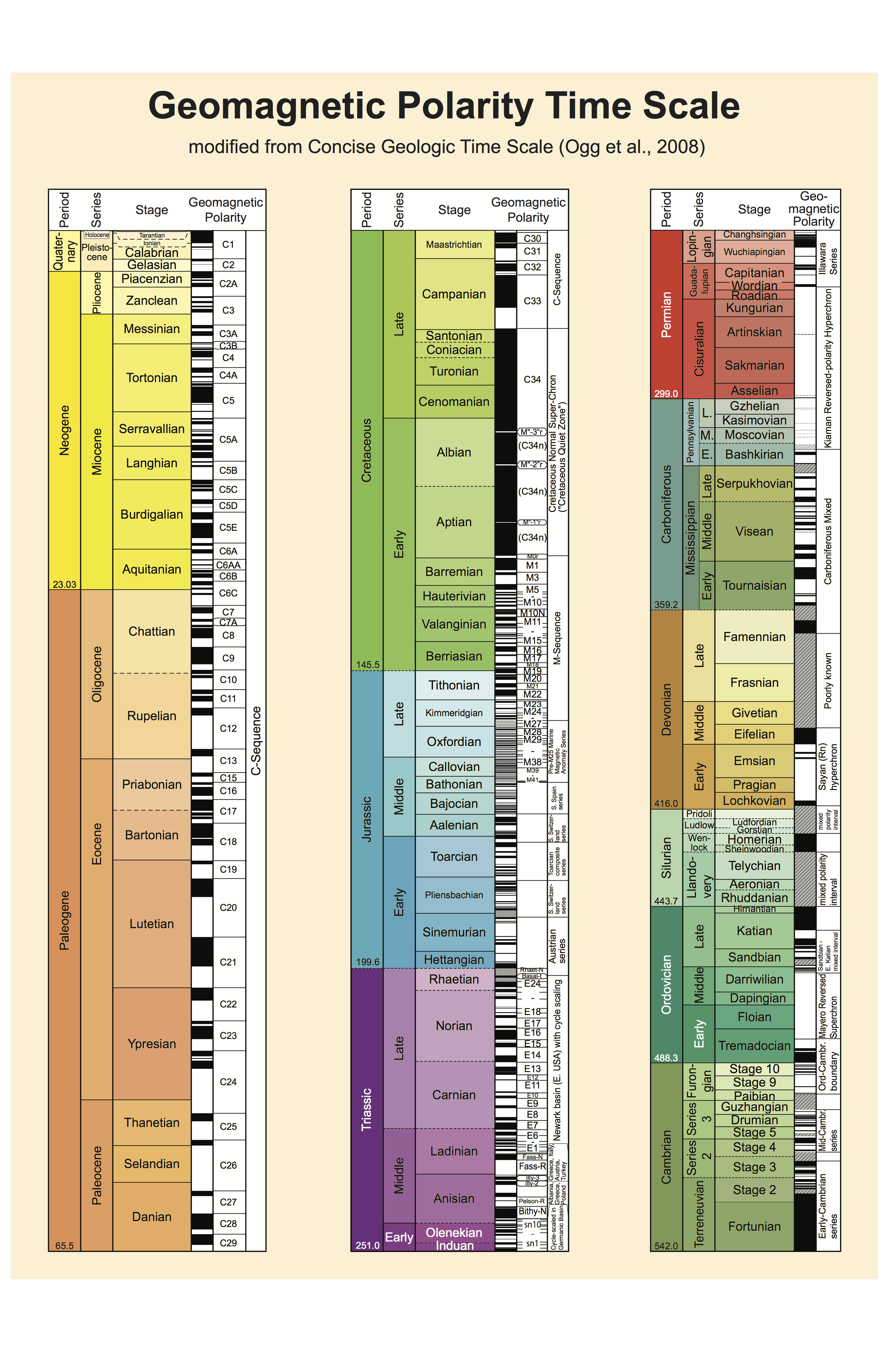
Figure 2: This is the Magnetic Polarity Time Scale correlated to the Geologic time scale. Black periods are "normal" (North points to today's true north) and white periods are "reversed". Figure: from Libretexts
The drawbacks of magnetostratigraphy are:
- Magnetostratigraphy requires a stratigraphic section in which a pattern of reversals is visible! Whereas a lithostratigraphic marker bed, biozone, or chemostratigraphic anomaly might be recognized from a single outcrop.
-
Changes in depositional rate or disconformities can obscure/alter the magnetostratigraphic pattern within a stratigraphic section
-
Some intervals of geologic time are not useful because they contain few reversals so it is hard to correlate it to the Magnetic Polarity Time Scale
What is Sequence Stratigraphy?
This section based on this webpage
Sequence stratigraphy is the branch of sedimentary stratigraphy that deals with the order/sequence in which depositionally related strata (rock units) were laid down in the available spaces at the time of deposition. Basically, it is the analysis of sedimentary deposits in a time-stratigraphic context and involves subdividing sedimentary basin fill into individual sequences of deposition which can then be linked to changes in the two parameters of sediment supply and accommodation. The main purpose of this technique is to reconstruct how sediments filled a basin and how the stratigraphy was formed through space and time. Sequence stratigraphy can help geologists figure out how sea level has changed by looking for where coarse and fine grained sediments were deposited within a basin. Below are some terms used in sequence stratigraphy:
- Eustasy - sea level at a given time (influenced by tectonic movement)
- Transgression - periods of sea level rise which leave retrogradational stacking patterns of strata
- Regression - periods of sea level fall which leave progradational stacking patterns of strata
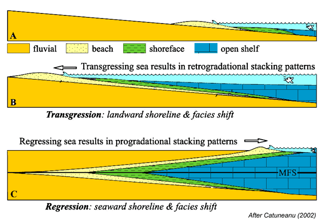
Figure 3: The depositional effects of sea rise and fall on stratigraphy. Note the different stratigraphic layers and how transgression and regression have distinct patterns. Photo: SEPM Strata
In the figure above, the effects of transgression and regression are shown. Sea level rise results in a retrogradational stacking pattern while sea level fall results in a progradational stacking pattern. In B, the beach layer is spread out and moved up the beach as the sea level rises. In C, the beach layer is spread out and pulled back in to the ocean as the sea level falls.
In sequence stratigraphic models, sediment supply is often assumed to be constant while accommodation (the space available for potential sediment accumulation) changes through time as a result of fluctuations in sea level. The different sedimentary sequences refer to the amount of stratigraphy that was deposited during an episode of sea level fall and subsequent rise. Sequence stratigraphic models are a simplification of of what actually happened and are often complicated and full of difficult terminology, but it is still a very useful tool for economic geologists because it allows them to better understand the stratigraphy of sedimentary basins of value.
What is Biostratigraphy?
A more in depth explanation can be found here: Biostratigraphy
The basic idea is for the geologist to identify fossils in the stratigraphic columns, compare them to the ranges of those organisms know from previous studies, and then interpret the age of the rocks from documented extinction and species origination events. Finding the same index fossil in two spatially distanced stratigraphic units allows us to constrain their time of deposition to the same time. This is done with index fossils which are fossils that have the following characteristics:
- have short geological ranges (they did not live for millions of years, and evolved quickly)
- were distributed over a large region of the earth
- were easily preserved
- were abundant and are well studied.
This method is particularly useful because it does not depend on isotope dating for an accurate estimate of the age of stratigraphic units. The issues though are that fossil species need to have the characteristics of a good index fossil and it needs to be relevant to whatever you are studying.
Works Cited:
All notes from Dawn Sumner, UC Davis GEL 109:
https://geo.libretexts.org/Courses/University_of_California_Davis/UCD_GEL_109%3A_Sediments_and_Strata_(Sumner)/08%3A_Old_or_Lost_Pages/8.04%3A_Chronostratigraphy
Figures from libretexts and SEPM Strata http://sepmstrata.org/page.aspx?&pageid=229&3