
10.1: Alluvial and Fluvial Systems
- Page ID
- 20421
Alluvial Fans
Alluvial fans are mounds of coarse grained sediments formed when a confined stream disgorges into an unconfined area. They typically occur along the margins of mountain ranges where bedrock incised channels draining uplands spill out on to broad open valley floors. Alluvial fans occur in areas with significant topographic relief caused by rapid subsidence or uplift (rift basins, foreland basins, fold-and-thrust belts, etc.). They are semi-circular in map view, form mounds in transverse cross section, and form basinward-thinning wedges in lateral cross sections.
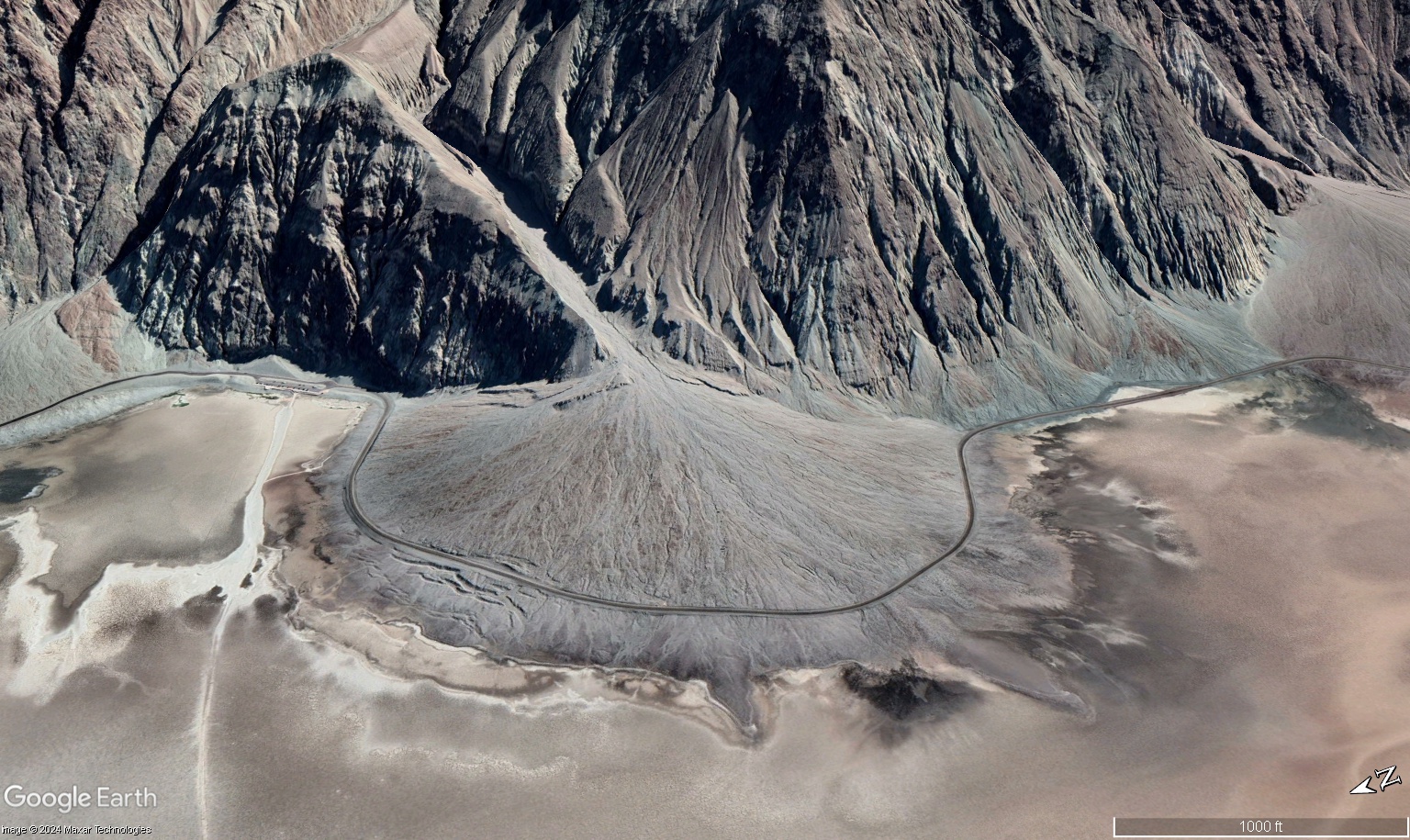
Figure \(\PageIndex{1}\): Oblique image of an alluvial fan building into the Badwater Basin in Death Valley, National Park shown with 1.5x vertical exaggeration. Notice that the fan originates at the point where the flow emerges from the bedrock-confined channel. The pronounced line around the edge of the alluvial fan is Badwater Road (Courtesy Google Earth, image is ©2024 Maxar Technologies; exported images from Google Earth can be embedded on websites for educational and non-commercial use).
Internally, alluvial fans typically include debris flow deposits composed of poorly-sorted, possibly matrix-supported conglomerates, breccias, and/or diamictites and stream flow deposits composed of sorted and stratified sand and gravel. Grain size generally increases toward the mountain front and decreases in a basinward direction. Sediments commonly occur in coarsening upward cycles that record tectonic and sedimentary pulses. (Paleo)flow is generally in a radial pattern away from the source.
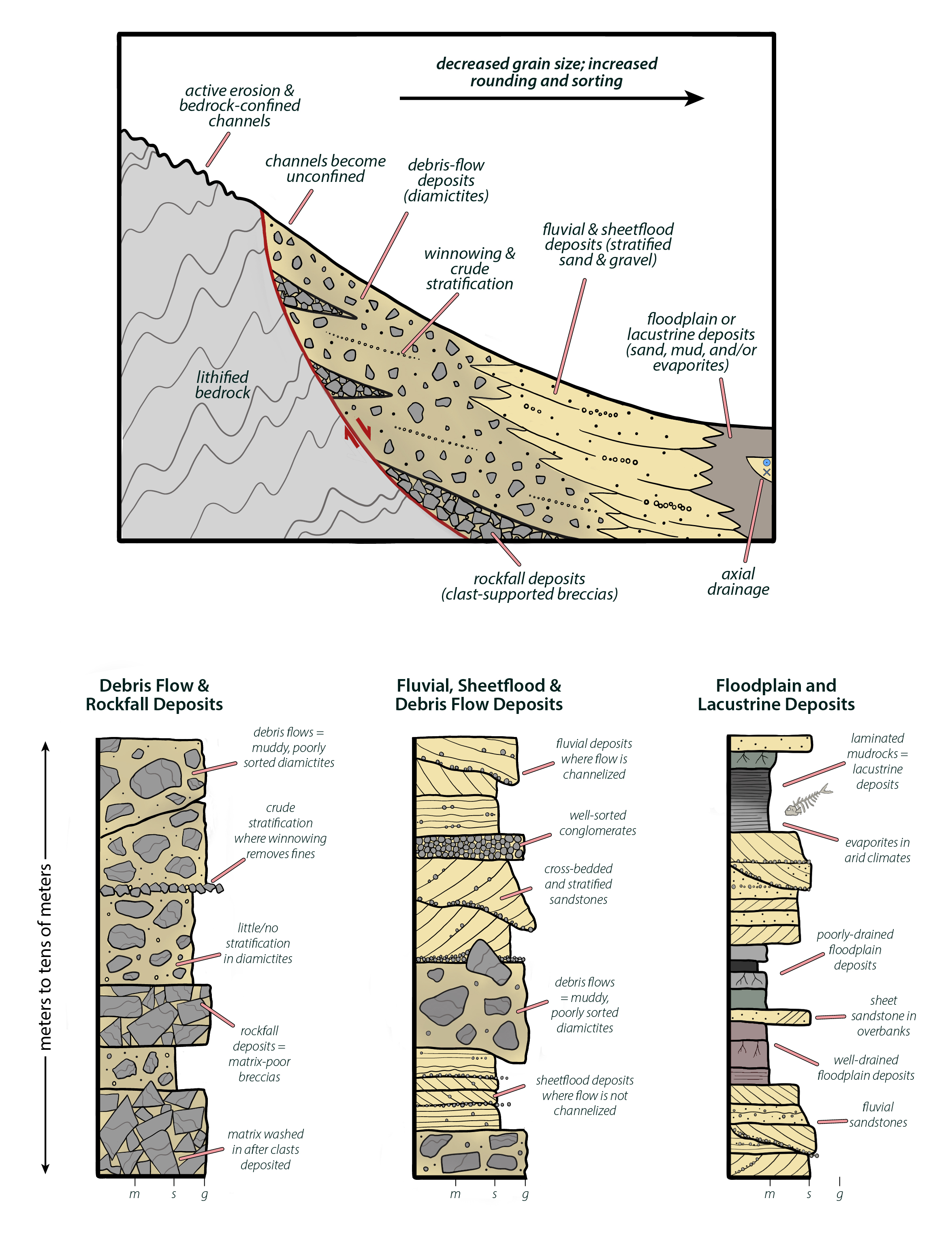
Figure \(\PageIndex{2}\): Cross-sectional sketch of an alluvial fan and schematic measured sections through alluvial fan deposits.
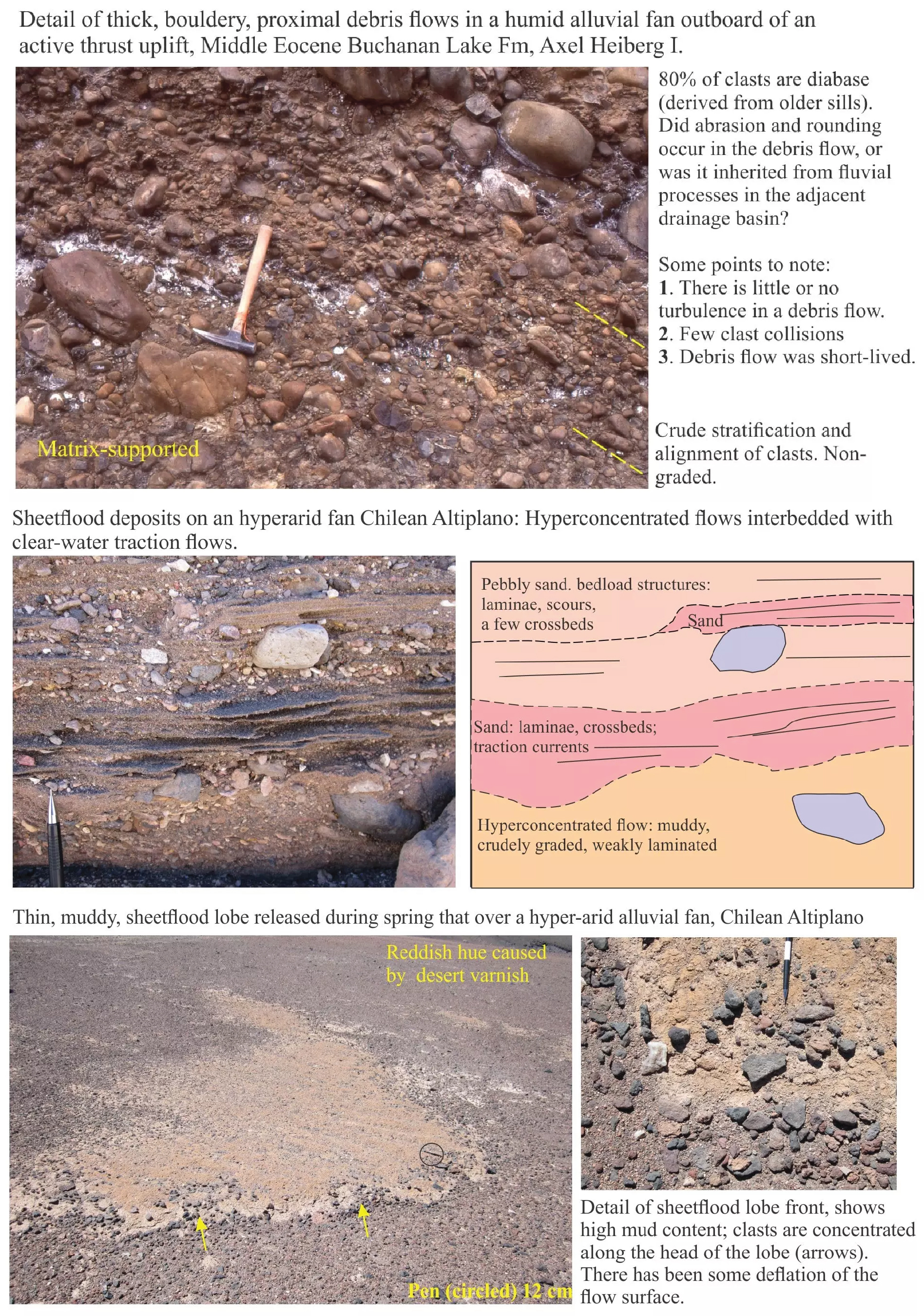
Figure \(\PageIndex{3}\): A variety of debris flow, stream flow, and sheet flood deposits in alluvial fans (Brian Ricketts via https://www.geological-digressions.com/sedimentary-structures-alluvial-fans; CC BY-SA 4.0).
Fluvial Deposits
Rivers are areas where overland flow is concentrated in a channel. Floodplains are the areas adjacent to channels that are periodically inundated during floods. Although we commonly think of river channels as u-shaped features, they exhibit a wide range of geomorphic variability and are commonly preserved as complex, amalgamated bodies in the geologic record. The orientation of the outcrop relative to paleoflow direction can also influence one's perception of channel body geometry. A simple channel that appeared u-shaped when viewed perpendicular to paleoflow direction could appear like an elongate sand ribbon if viewed parallel to paleoflow. Modern rivers can be characterized using a variety of criteria including sinuosity, number of active channels, types of bars, and numerous other characteristics. For our purposes, we will take an admittedly oversimplified approach and focus on three points in the continuum of fluvial style: braided, meandering, and anastomosed (aka fixed).
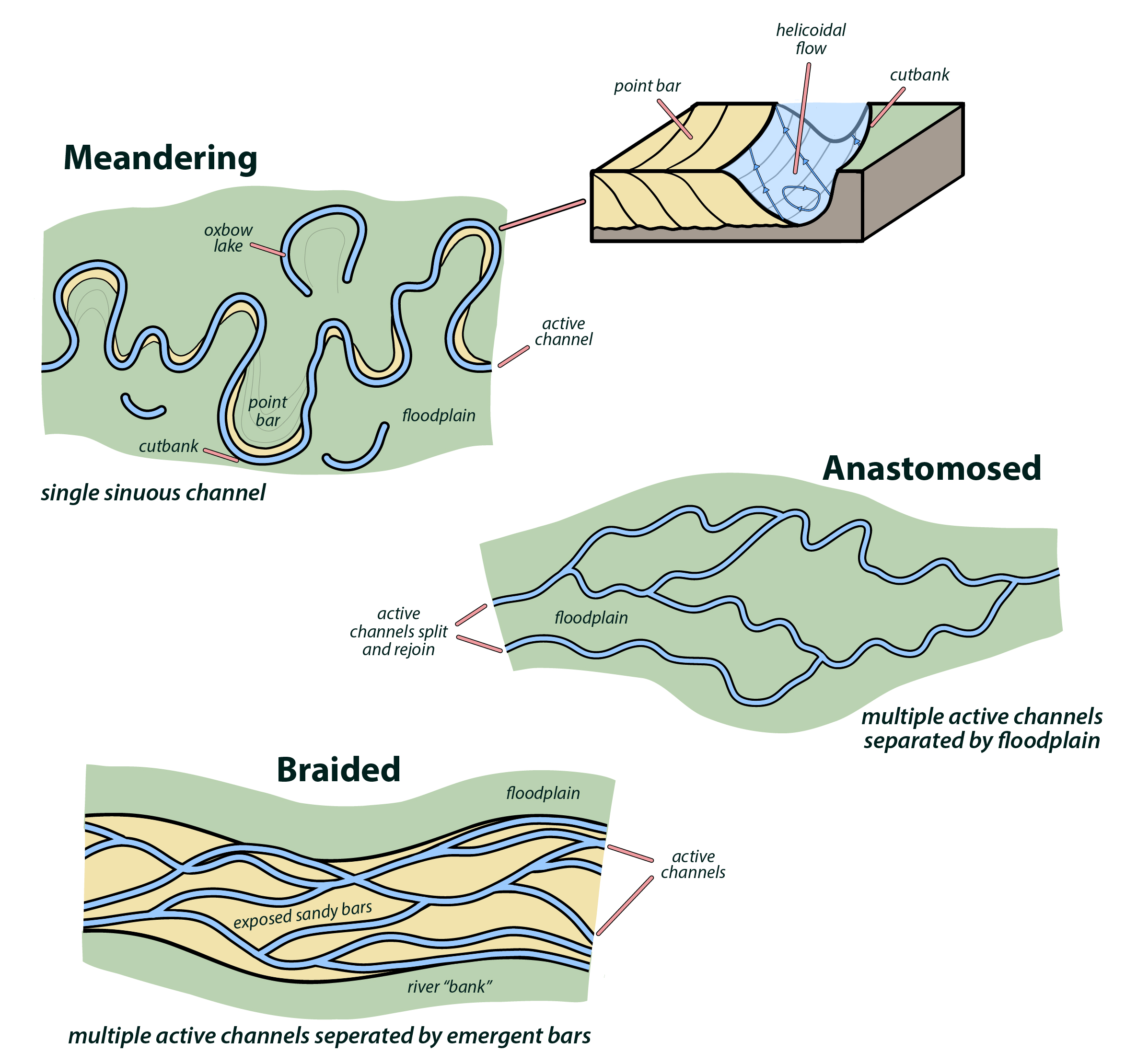
Figure \(\PageIndex{4}\): Points in the continuum of fluvial form. Green areas represent floodplains, yellow areas are emergent sandy bars, and blue areas are active channels. Diagram after Miall (1977) and Leeder (2009).
Braided Rivers
Braided systems consist of a broad "river" with an interwoven network of active channels separated by emergent bars. They are typically bedload-choked sand- and/or gravel-dominated systems with bars that typically migrate in a downstream direction. Given the coarse nature of the sediment and the overabundance of bedload, most sediment transport happens during flood stage when the entire river is bankfull and within-channel bars are submerged.
Overall, abundant bedload makes for unstable banks and sand- or gravel deposits with only modest amounts of mud and abundant erosion surfaces. Overall, active channel deposits are much more abundant than floodplain deposits. The Platte River of Nebraska is one of the best known modern braided rivers; well exposed and documented systems include the Castlegate Sandstone (Cretaceous) and the South Bar Formation (Pennsylvanian).
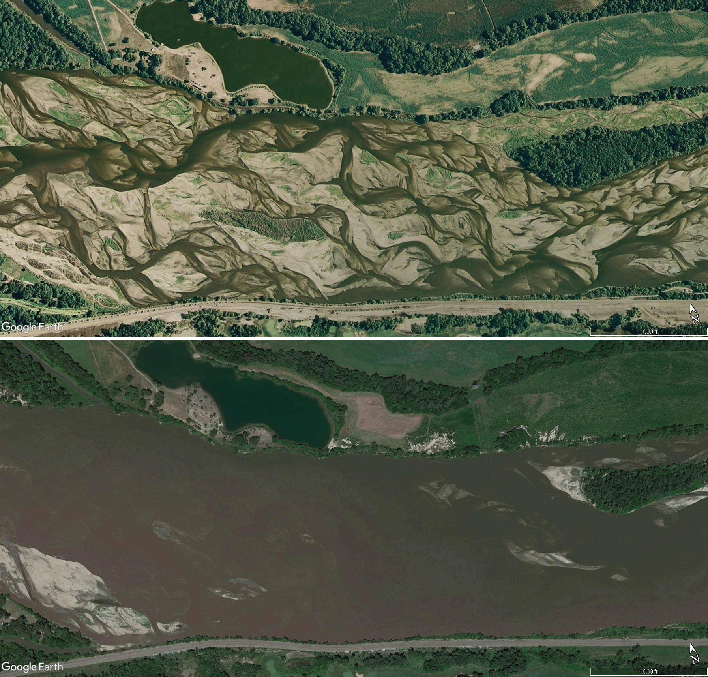
Figure \(\PageIndex{5}\): Google Earth images showing the same segment of the braided Platte River under low/normal flow conditions in August 2006 (above) and at bankfull stage in June 2001. In these bedload-choked systems, most sediment transport happens during flood and bankfull flows (courtesy Google Earth, exported images from Google Earth can be embedded on websites for educational and non-commercial use).
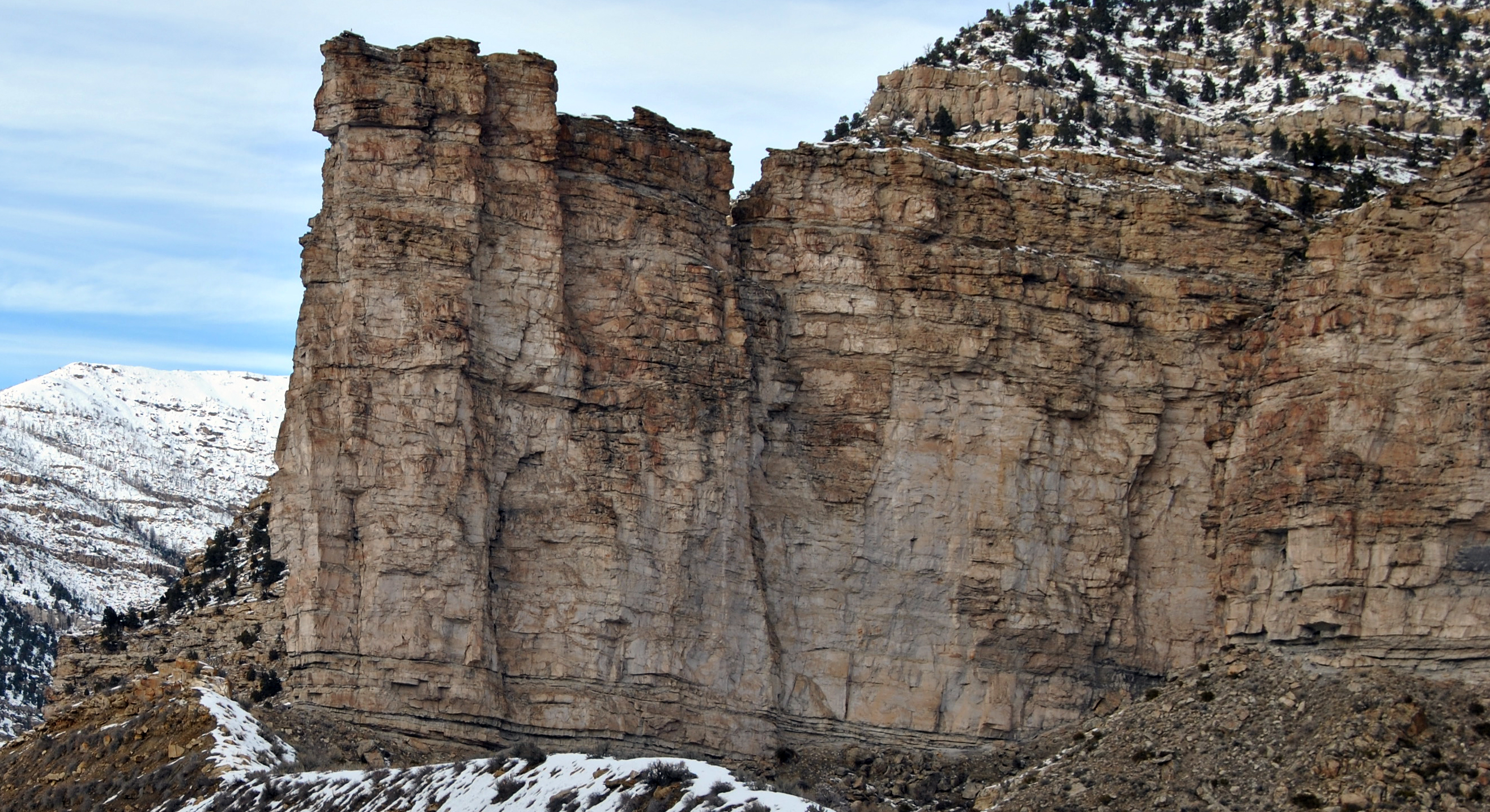
Figure \(\PageIndex{6}\): The Cretaceous Castlegate Sandstone is a well known and well studied sandy braided fluvial deposit (Loco Steve via Flickr; CC BY 2.0). Notice the abundance of sandstone, the numerous internal erosion surfaces, and the paucity of mudrock.
Meandering Rivers
Meandering rivers have a sinuous main channel with a broad, often muddy, floodplain. They typically occur in low gradient areas, carry a mixture of bedload and suspended load, and have more energy than they need to carry the sediment load. They expend the excess energy winding across the floodplain and distributing sediment across it. Internally, the water in channels actually moves downstream in a corkscrew fashion (helicoidal flow) which facilitates erosion on the cutbank and deposition on the opposing pointbar. Sinuosity increases with continued cutbank erosion and pointbar deposition, which gives meandering systems their distinctive sinuous patter. Eventually curvature increases to the point where a reach of the river gets cut off and isolated forming an oxbow lake. The oxbow lake is filled with standing water and eventually fills in with mud and/or organic material.
Overall, meandering river systems generally consist of sandy or heterolithic channel deposits encased within finer floodplain deposits. In a vertical section, a fining-upward trend may be formed by the progression from the (relatively) coarse basal channel deposits, through sandy and heterolithic point bar deposits, and eventually into finer grained floodplain deposits. The Mississippi River is, by far, the best know modern meandering river; noteworthy ancient examples include portions of the Devonian Catskill Formation of PA and NY and the Cretaceous McMurray Formation of Alberta.

Figure \(\PageIndex{7}\): One of Harold Fisk's (1944) maps showing former courses of the Mississippi River; the different colors represent the path of the river at different points in time since the last glacial maximum (U.S. Army Corps of Engineers via Radical Cartography; public domain).
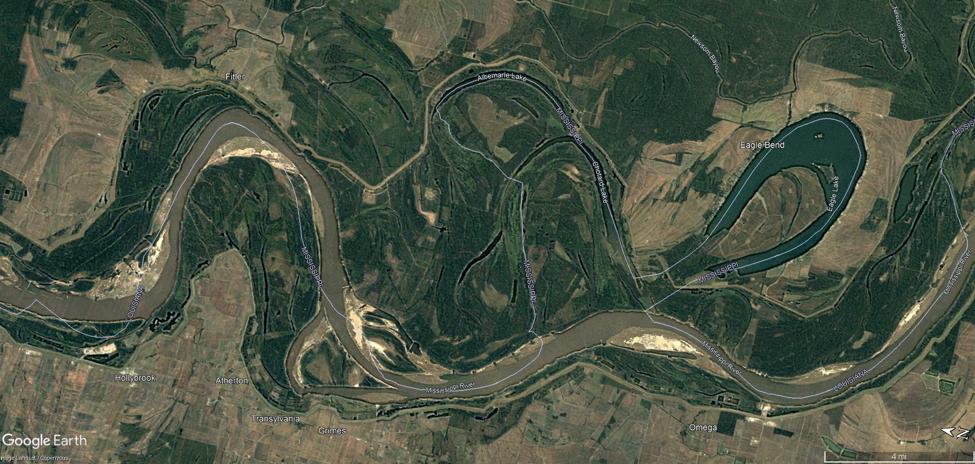
Figure \(\PageIndex{8}\): Google Earth image showing a meandering portion of the Mississippi River. The light blue lines represent the boundary between the states of Mississippi (north) and Louisiana (south); the border was originally drawn down the middle of the active river channel - that course has now been abandoned in numerous places (courtesy Google Earth, image is from Landsat/Copernicus; exported images from Google Earth can be embedded on websites for educational and non-commercial use).
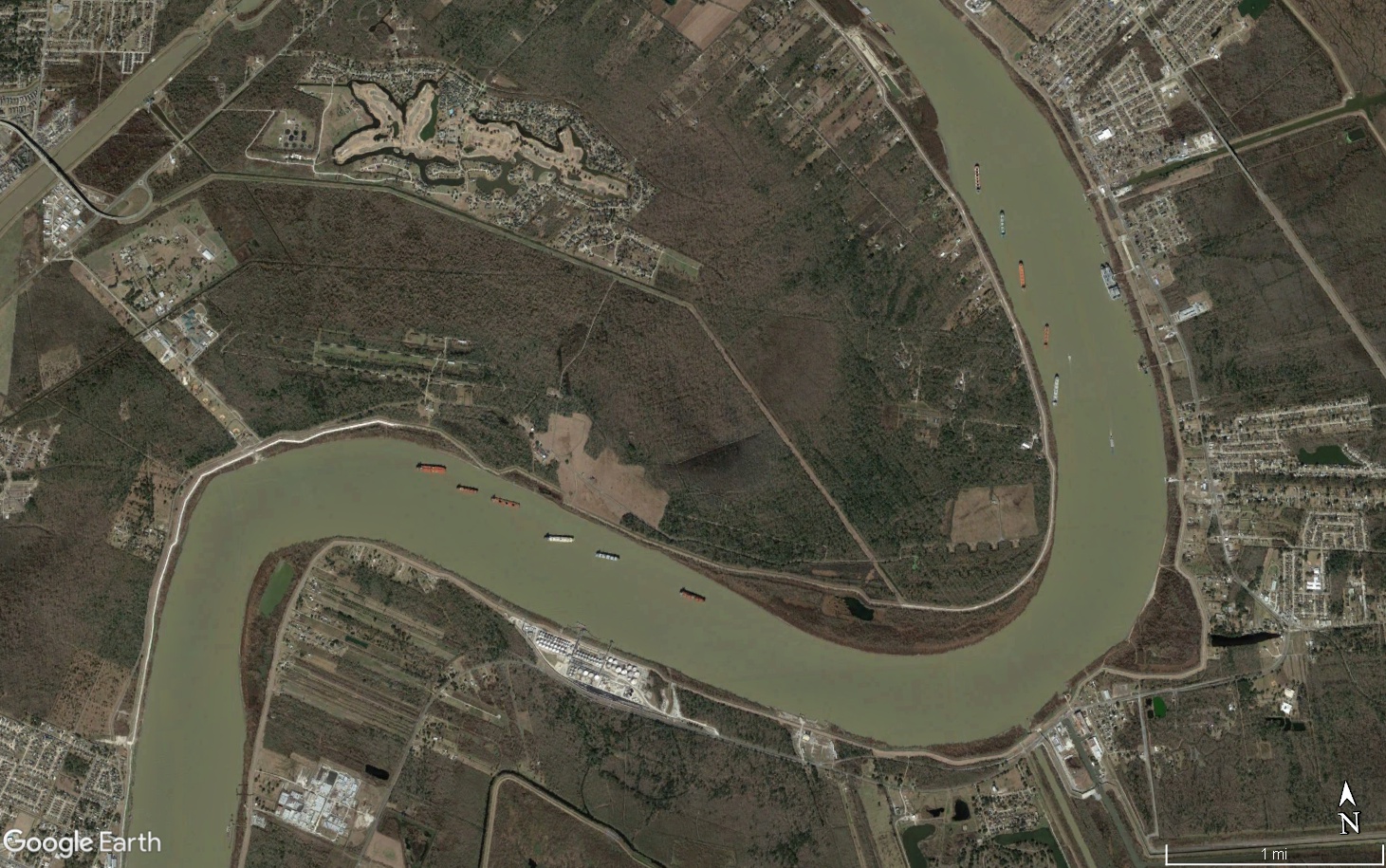
Figure \(\PageIndex{9}\): Google Earth image showing anchored ships aligned by helicoidal flow. Flow is from the top of the image toward the bottom. Ships are anchored on their upstream side and aligned by helicoidal flow so that the long axis of the ship points away from the cut bank and obliquely up the point bar (courtesy Google Earth; exported images from Google Earth can be embedded on websites for educational and non-commercial use).
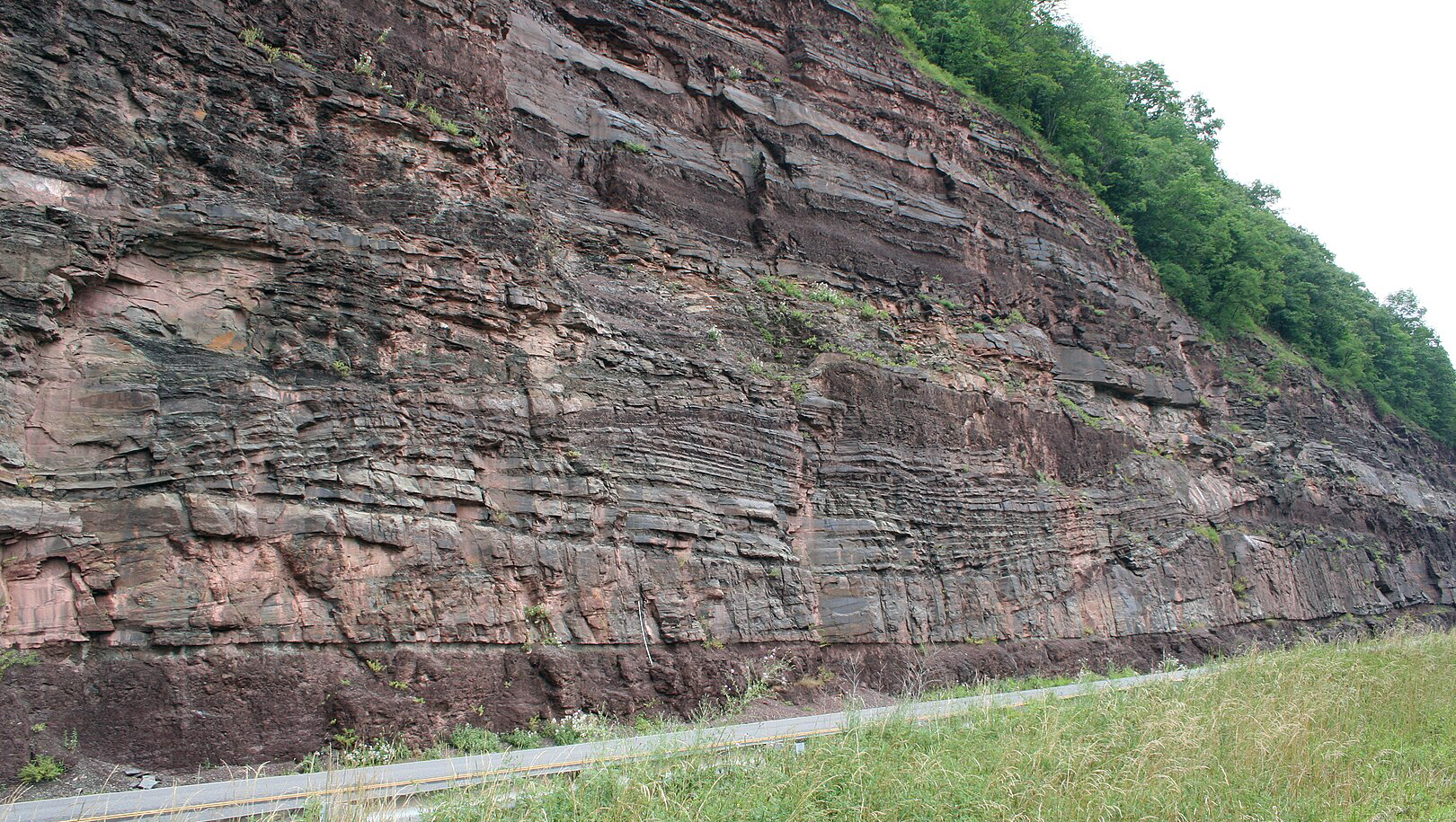
Figure \(\PageIndex{10}\): Inclined heterolithic strata making up point bar deposits in a meandering channel body, Devonian Catskill Formation near North Bend, PA (Michael C. Rygel via Wikimedia Commons; CC BY-SA 3.0).
Anastomosed Rivers
Anastomosed river systems have channels that are largely fixed in place without much lateral movement. They are commonly part of a larger drainage network with multiple interconnected channels separated by floodplains. In the geologic record it is difficult to prove that multiple channels were active simultaneously (especially given outcrops of limited lateral extent) so the best one can hope for is to find stable channels - ideally at the same level - isolated within floodplain deposits.

Figure \(\PageIndex{11}\): Google Earth image showing an anastomosed portion of the Columbia River near Spillimacheen, British Columbia (courtesy Google Earth, image is ©Province of British Columbia; exported images from Google Earth can be embedded on websites for educational and non-commercial use).

Figure \(\PageIndex{12}\): The u-shaped, sandstone-dominated channel bodies of the Pennsylvanian Springhill Mines Formation are interpreted as the deposits of an ancient anastomosed river system that delivered sediment into a rapidly subsiding basin (Michael C. Rygel via Wikimedia Commons; CC BY-SA 4.0).
Floodplain Deposits
Floodplain deposits consist of muddy sediment formed from suspension deposition following flooding events and sandy deposits in areas that were closer to higher velocity flows that were capable of moving bedload. Floodplain deposits may show evidence of subaerial exposure (desiccation cracks, raindrop imprints), evidence of plant growth or other terrestrial fossils, and/or evidence of pedogenesis including the destruction of bedding or the development of soil horizons.
Levees are areas of positive topographic relief on the floodplain that form adjacent to channels. They form when channelized flows overtop the river banks and rapidly deposit sediment as the flows become unconfined. Crevasse splays are lobe-shaped sand bodies that form where a channel breaches the levee and deposits a lobe of relatively coarse grained sediment.
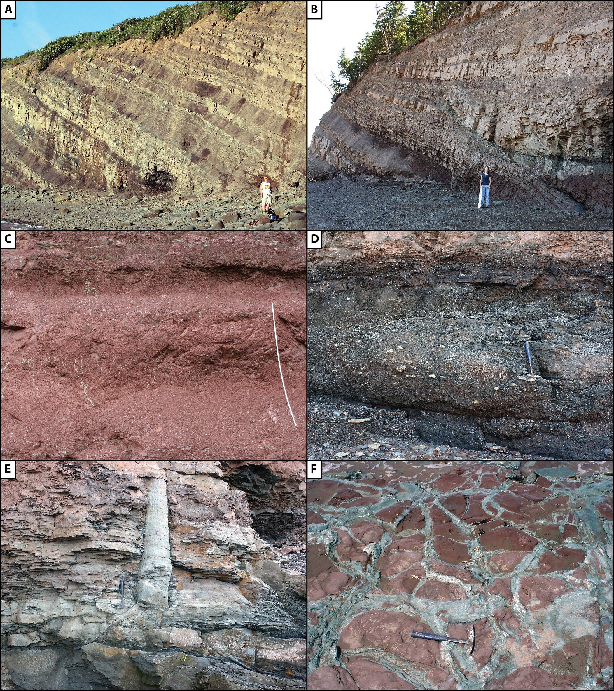
Figure \(\PageIndex{13}\): Floodplain deposits. A) Interbedded sheet sandstones and mudrocks are common floodplain deposits. The sheet sandstones represent energetic flow when riverbanks are overtopped and the mudrocks represent suspension deposition from standing water. B) Some sheet sandstones thicken toward and can be traced back to the channels that sourced the sediment; stacked packages of sheet sandstones can represent progradation of crevasse splay deposits. C) Although floodplain mudrocks start off as laminated or platy mudrocks, pedogenic processes can destroy bedding and red colors represent oxidizing conditions. D) Floodplain deposits can also record waterlogged conditions as evidenced by gray and green mudrocks and organic-rich horizons, and even thin coals. E & F) Fossils and sedimentary structures can provide evidence of terrestrial conditions and subaerial exposure (all images from Michael C. Rygel via Wikimedia Commons; various CC BY-SA licenses).
Avulsion and Aggradation
Avulsion is the process by which an active channel rapidly shifts to a different location on a topographically lower part of the floodplain. It happens when primary flow breaches a levee and diverts through a crevasse channel, usually during floods. If the new route provides a gradient advantage the active channel may shift to the new course.
Aggradation is the increase in land elevation due to sediment deposition. River channels and levees commonly aggrade together and become elevated above the floodplain. This process eventually raises the downstream elevation and decreases the gradient. If/when the levee is breached during a flood, the active channel will preferentially shift to a the new (steeper gradient) course.
Together, the avulsion and aggradation can profoundly influence the preservation of fluvial deposits. Low avulsion rates or high subsidence rates tend to produce isolated channel bodies; high avulsion rates or low subsidence rates tend to produce highly amalgamated channel bodies. These relationships get much more complex when the processes interact and vary.
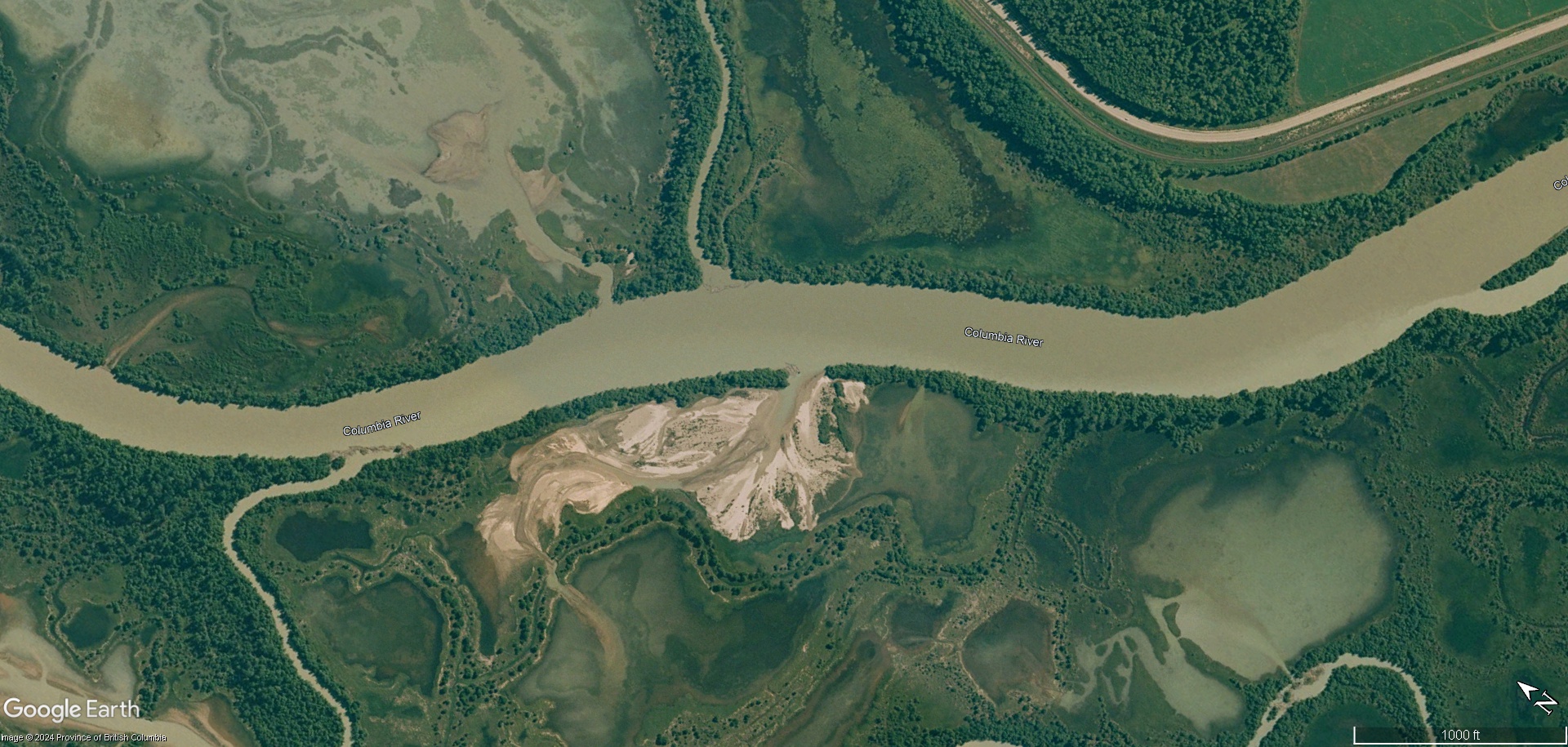
Figure \(\PageIndex{14}\): Google Earth image showing an active channel of the Columbia River, swampy floodplain areas, tree-covered levees, and a lobe-shaped sandy crevasse-splay deposit formed during a flood event. If there is a gradient advantage, the main channel could divert through the breach in the levee and avulse to a new course (courtesy Google Earth, image is ©Province of British Columbia; exported images from Google Earth can be embedded on websites for educational and non-commercial use).
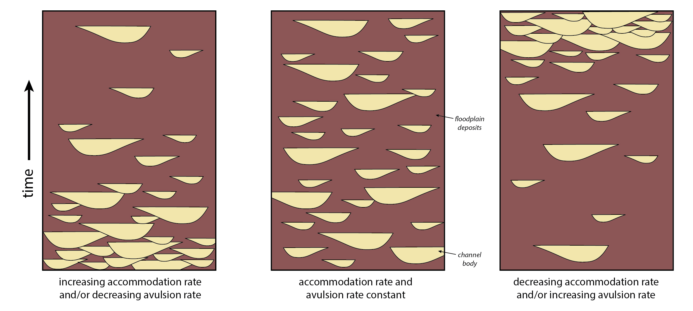
Figure \(\PageIndex{15}\): Diagrams showing the relationship between channel body amalgamation, avulsion rate, and sedimentation rate. Diagram from Michael C. Rygel via Wikimedia Commons; CC BY-SA 4.0 which is after Bryant et al. (1995).
Overview of fluvial deposits
Fluvial deposits are generally preserved as sand or gravel channel bodies that have erosional bases and may be amalgamated. Channel bodies may be encased in finer-grained floodplain deposits. Both river and floodplain deposits can contain evidence of fresh-water and/or terrestrial fossils. Floodplain deposits may show evidence of soil formation and subaerial exposure.
Additional Readings and Resources
- Bryant, M., Falk, P., & Paola, C., 1995, Experimental study of avulsion frequency and rate of deposition. Geology, 23(4), 365-368.
- Harold Fisk's 1944 maps of the Mississippi River: http://www.radicalcartography.net/index.html?fisk
- Leeder, M. R., 2009, Sedimentology and sedimentary basins: from turbulence to tectonics. John Wiley & Sons.
- Miall, A. D., 1977, A review of the braided-river depositional environment. Earth-Science Reviews, 13(1), 1-62.