
4.4: Erosional and Post-Depositional Structures
- Page ID
- 25762
\( \newcommand{\vecs}[1]{\overset { \scriptstyle \rightharpoonup} {\mathbf{#1}} } \)
\( \newcommand{\vecd}[1]{\overset{-\!-\!\rightharpoonup}{\vphantom{a}\smash {#1}}} \)
\( \newcommand{\id}{\mathrm{id}}\) \( \newcommand{\Span}{\mathrm{span}}\)
( \newcommand{\kernel}{\mathrm{null}\,}\) \( \newcommand{\range}{\mathrm{range}\,}\)
\( \newcommand{\RealPart}{\mathrm{Re}}\) \( \newcommand{\ImaginaryPart}{\mathrm{Im}}\)
\( \newcommand{\Argument}{\mathrm{Arg}}\) \( \newcommand{\norm}[1]{\| #1 \|}\)
\( \newcommand{\inner}[2]{\langle #1, #2 \rangle}\)
\( \newcommand{\Span}{\mathrm{span}}\)
\( \newcommand{\id}{\mathrm{id}}\)
\( \newcommand{\Span}{\mathrm{span}}\)
\( \newcommand{\kernel}{\mathrm{null}\,}\)
\( \newcommand{\range}{\mathrm{range}\,}\)
\( \newcommand{\RealPart}{\mathrm{Re}}\)
\( \newcommand{\ImaginaryPart}{\mathrm{Im}}\)
\( \newcommand{\Argument}{\mathrm{Arg}}\)
\( \newcommand{\norm}[1]{\| #1 \|}\)
\( \newcommand{\inner}[2]{\langle #1, #2 \rangle}\)
\( \newcommand{\Span}{\mathrm{span}}\) \( \newcommand{\AA}{\unicode[.8,0]{x212B}}\)
\( \newcommand{\vectorA}[1]{\vec{#1}} % arrow\)
\( \newcommand{\vectorAt}[1]{\vec{\text{#1}}} % arrow\)
\( \newcommand{\vectorB}[1]{\overset { \scriptstyle \rightharpoonup} {\mathbf{#1}} } \)
\( \newcommand{\vectorC}[1]{\textbf{#1}} \)
\( \newcommand{\vectorD}[1]{\overrightarrow{#1}} \)
\( \newcommand{\vectorDt}[1]{\overrightarrow{\text{#1}}} \)
\( \newcommand{\vectE}[1]{\overset{-\!-\!\rightharpoonup}{\vphantom{a}\smash{\mathbf {#1}}}} \)
\( \newcommand{\vecs}[1]{\overset { \scriptstyle \rightharpoonup} {\mathbf{#1}} } \)
\( \newcommand{\vecd}[1]{\overset{-\!-\!\rightharpoonup}{\vphantom{a}\smash {#1}}} \)
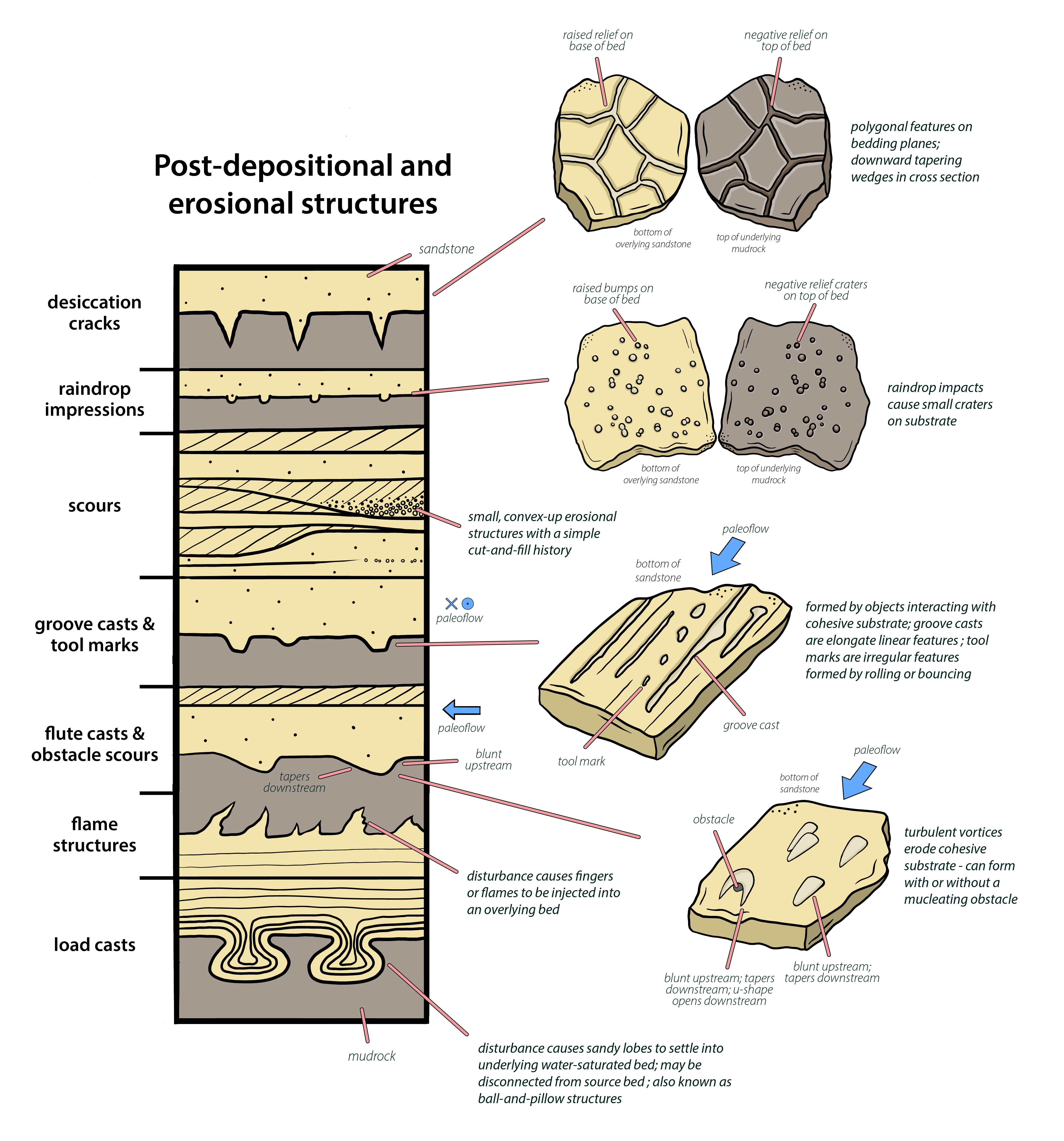
Figure \(\PageIndex{1}\): Diagram showing erosional and post-depositional structures (Page Quinton via Wikimedia Commons; CC BY-SA 4.0). Note that labels on some of the pop-outs to the right show whether the top or bottom of a bed is pictured.
Erosional Structures
Scours and Channels
Channels form where flowing water concentrates and erodes the underlying sediment. Eventually the sediment being carried by the river fills the channel and the river avulses to another location on the floodplain. Although we commonly think of channel deposits as being simple u-shaped features, their morphology is a function of the type of river, the orientation of the outcrop relative to paleoflow direction, and whether or not the channel deposit was modified by later rivers. We will get into some of these differences when we start talking about depositional environments later in the course.
We are not aware of a strict size range applied to channels. But generally speaking, many people use the term scours to refer to small, non-descript erosional features within floodplain or beach sediments indicating a simple cut-and-fill history.

Figure \(\PageIndex{2}\): A) Small scour in shoreface sandstones of the Permian Wasp Head Formation, New South Wales. B) Erosive margin of a paleovalley in the Pennsylvanian Waddens Cove Formation, Nova Scotia (both images from Michael C. Rygel via Wikimedia Commons; CC BY-SA 4.0).
Groove Casts and Tool Marks
Objects drug by a moving current can make a variety of indentations into cohesive substrate. Groove casts refer to elongate linear features caused by dragging and tool marks refers to less linear features formed by rolling or bouncing along the sediment surface. If sand later blankets the sediment surface these marks may be infilled and preserved on the base of the overlying sandstone.
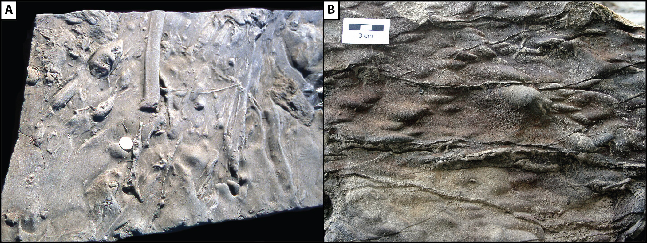
Figure \(\PageIndex{3}\): A) Groove casts and tool marks on the base of a bed of sandstone. Given that many of these marks taper toward the top of the image, the paleoflow direction was probably bottom to top. B) Flute casts on the base of a sandstone from the Inverness Formation (Pennsylvanian), western Cape Breton, Nova Scotia. Flute casts are bulbous on the upstream side and taper on the downstream side; in this case recording paleoflow from right to left (both images from Michael C. Rygel via Wikimedia Commons; CC BY-SA 3.0 or CC BY-SA 4.0).
Flute Casts
Flutes form where a turbulent vortex erodes into muddy sediment. It forms a depression that is blunt upstream and tapers downstream. If later infilled with sand, they can be preserved as casts that stand in relief on the base of a bed of sandstone. They are useful for determining paleoflow direction because the blunt end bases upstream.
Obstacle Scours
Where you have a fixed obstruction (rock, tree, etc) a moving current will commonly scour a deep hole around the side and upstream edge of the feature forming a u-shaped depression that opens downstream. Although not terribly common, it is possible to preserve these obstacle scours in the geologic record.

Figure \(\PageIndex{4}\): A) Obstacle scour around a tree. The deepest part of the scour is on the upstream side of the obstacle; turbulent vortices are shed off the sides of the obstacle and create a u-shaped scour pit that opens in a downstream direction; in this case flow was from left to right. B) Obstacle scours (aka current crescents) preserved on a bedding plane in a fluvial sandstone of the Pennsylvanian Ragged Reef Formation. Flow direction was from top to bottom (both images from Michael C. Rygel via Wikimedia Commons; CC BY-SA 3.0).
Soft-Sediment Deformation Structures
The sedimentary structures described above were all “primary” sedimentary structures in that they record conditions at or near the time that the sediment was deposited. The structures described below are all "secondary" structures in the sense that they show modification of the sediment after it was deposited but before it underwent diagenesis (the process that transforms sediment to rock).
Flame Structures
When water-saturated mud is overlain by more dense sand, compaction and/or a slight disturbance can cause flame structures which are tongues of mud to inject upward into the overlying sand
Load Casts
Load cast (aka ball-and-pillow structures) are sandy lobes of mud that can form when dense mud settles down into water-saturated mud as a result of compaction or disturbance. They may be be connected to source bed or may be isolated from it. Superficially they can appear similar to flute casts but they lack the pronounced blunted edge.
A wide variety of other types of nameless synsedimentary deformation features can form when shaking or loading of water-laden muds can cause overall chaotic bedding in rocks. The key to distinguishing these features from those formed as a result of tectonic forces is that over and underlying beds are flat-lying and relatively undeformed.
text

Figure \(\PageIndex{5}\): A) Cross-sectional view of load casts (aka ball-and-pillow structures) in the Booti Booti Sandstone (Mississippian), New South Wales (Michael C. Rygel via Wikimedia Commons; CC BY-SA 3.0). B) Flame structures in unconsolidated sand, (Catrin1000via Wikimedia Commons; public domain).
Desiccation cracks
As mentioned above, mud can be 70% water. When it dries out it contracts forming polygonal mudcracks. These features can be preserved as polygonal features on bedding planes or as downward tapering wedges if viewed in cross section.

Figure \(\PageIndex{6}\): A) Oblique view of modern dessication cracks atop a tidally-influenced point bar in the Salmon River near Truro, Nova Scotia. B) Slightly oblique bedding plane view of green reduced zones associated with dessication cracks in the in the Pennsylvanian Clifton Formation, New Brunswick. C) Cross-sectional view of mudcracks in the Mississippian Mabou Group, Nova Scotia. D) Dessication crack preserved as a cast on the base of a sandstone, Inverness Formation (Pennsylvanian), Cape Breton Island, Nova Scotia. E) Modern raindrop impressions on a tidally-influenced point bar in the Salmon River near Truro, Nova Scotia. F) Fossilized raindrop impressions on the top of a wave-rippled sandstone from the Horton Bluff Formation (Mississippian), near Avonport, Nova Scotia. All images by Michael C. Rygel via Wikimedia Commons; CC BY-SA 3.0 or CC BY-SA 4.0)
Raindrop Impressions
When raindrops fall onto fine-grained sediment they make small depressions or craters on the top of that sediment. These features can be preserved either as depressions on the top of the fine-grained sediment that they fell on or as bumpy casts on the base of the overlying bed.