12.3: Shoreline Features
- Page ID
- 32244
\( \newcommand{\vecs}[1]{\overset { \scriptstyle \rightharpoonup} {\mathbf{#1}} } \)
\( \newcommand{\vecd}[1]{\overset{-\!-\!\rightharpoonup}{\vphantom{a}\smash {#1}}} \)
\( \newcommand{\dsum}{\displaystyle\sum\limits} \)
\( \newcommand{\dint}{\displaystyle\int\limits} \)
\( \newcommand{\dlim}{\displaystyle\lim\limits} \)
\( \newcommand{\id}{\mathrm{id}}\) \( \newcommand{\Span}{\mathrm{span}}\)
( \newcommand{\kernel}{\mathrm{null}\,}\) \( \newcommand{\range}{\mathrm{range}\,}\)
\( \newcommand{\RealPart}{\mathrm{Re}}\) \( \newcommand{\ImaginaryPart}{\mathrm{Im}}\)
\( \newcommand{\Argument}{\mathrm{Arg}}\) \( \newcommand{\norm}[1]{\| #1 \|}\)
\( \newcommand{\inner}[2]{\langle #1, #2 \rangle}\)
\( \newcommand{\Span}{\mathrm{span}}\)
\( \newcommand{\id}{\mathrm{id}}\)
\( \newcommand{\Span}{\mathrm{span}}\)
\( \newcommand{\kernel}{\mathrm{null}\,}\)
\( \newcommand{\range}{\mathrm{range}\,}\)
\( \newcommand{\RealPart}{\mathrm{Re}}\)
\( \newcommand{\ImaginaryPart}{\mathrm{Im}}\)
\( \newcommand{\Argument}{\mathrm{Arg}}\)
\( \newcommand{\norm}[1]{\| #1 \|}\)
\( \newcommand{\inner}[2]{\langle #1, #2 \rangle}\)
\( \newcommand{\Span}{\mathrm{span}}\) \( \newcommand{\AA}{\unicode[.8,0]{x212B}}\)
\( \newcommand{\vectorA}[1]{\vec{#1}} % arrow\)
\( \newcommand{\vectorAt}[1]{\vec{\text{#1}}} % arrow\)
\( \newcommand{\vectorB}[1]{\overset { \scriptstyle \rightharpoonup} {\mathbf{#1}} } \)
\( \newcommand{\vectorC}[1]{\textbf{#1}} \)
\( \newcommand{\vectorD}[1]{\overrightarrow{#1}} \)
\( \newcommand{\vectorDt}[1]{\overrightarrow{\text{#1}}} \)
\( \newcommand{\vectE}[1]{\overset{-\!-\!\rightharpoonup}{\vphantom{a}\smash{\mathbf {#1}}}} \)
\( \newcommand{\vecs}[1]{\overset { \scriptstyle \rightharpoonup} {\mathbf{#1}} } \)
\(\newcommand{\longvect}{\overrightarrow}\)
\( \newcommand{\vecd}[1]{\overset{-\!-\!\rightharpoonup}{\vphantom{a}\smash {#1}}} \)
\(\newcommand{\avec}{\mathbf a}\) \(\newcommand{\bvec}{\mathbf b}\) \(\newcommand{\cvec}{\mathbf c}\) \(\newcommand{\dvec}{\mathbf d}\) \(\newcommand{\dtil}{\widetilde{\mathbf d}}\) \(\newcommand{\evec}{\mathbf e}\) \(\newcommand{\fvec}{\mathbf f}\) \(\newcommand{\nvec}{\mathbf n}\) \(\newcommand{\pvec}{\mathbf p}\) \(\newcommand{\qvec}{\mathbf q}\) \(\newcommand{\svec}{\mathbf s}\) \(\newcommand{\tvec}{\mathbf t}\) \(\newcommand{\uvec}{\mathbf u}\) \(\newcommand{\vvec}{\mathbf v}\) \(\newcommand{\wvec}{\mathbf w}\) \(\newcommand{\xvec}{\mathbf x}\) \(\newcommand{\yvec}{\mathbf y}\) \(\newcommand{\zvec}{\mathbf z}\) \(\newcommand{\rvec}{\mathbf r}\) \(\newcommand{\mvec}{\mathbf m}\) \(\newcommand{\zerovec}{\mathbf 0}\) \(\newcommand{\onevec}{\mathbf 1}\) \(\newcommand{\real}{\mathbb R}\) \(\newcommand{\twovec}[2]{\left[\begin{array}{r}#1 \\ #2 \end{array}\right]}\) \(\newcommand{\ctwovec}[2]{\left[\begin{array}{c}#1 \\ #2 \end{array}\right]}\) \(\newcommand{\threevec}[3]{\left[\begin{array}{r}#1 \\ #2 \\ #3 \end{array}\right]}\) \(\newcommand{\cthreevec}[3]{\left[\begin{array}{c}#1 \\ #2 \\ #3 \end{array}\right]}\) \(\newcommand{\fourvec}[4]{\left[\begin{array}{r}#1 \\ #2 \\ #3 \\ #4 \end{array}\right]}\) \(\newcommand{\cfourvec}[4]{\left[\begin{array}{c}#1 \\ #2 \\ #3 \\ #4 \end{array}\right]}\) \(\newcommand{\fivevec}[5]{\left[\begin{array}{r}#1 \\ #2 \\ #3 \\ #4 \\ #5 \\ \end{array}\right]}\) \(\newcommand{\cfivevec}[5]{\left[\begin{array}{c}#1 \\ #2 \\ #3 \\ #4 \\ #5 \\ \end{array}\right]}\) \(\newcommand{\mattwo}[4]{\left[\begin{array}{rr}#1 \amp #2 \\ #3 \amp #4 \\ \end{array}\right]}\) \(\newcommand{\laspan}[1]{\text{Span}\{#1\}}\) \(\newcommand{\bcal}{\cal B}\) \(\newcommand{\ccal}{\cal C}\) \(\newcommand{\scal}{\cal S}\) \(\newcommand{\wcal}{\cal W}\) \(\newcommand{\ecal}{\cal E}\) \(\newcommand{\coords}[2]{\left\{#1\right\}_{#2}}\) \(\newcommand{\gray}[1]{\color{gray}{#1}}\) \(\newcommand{\lgray}[1]{\color{lightgray}{#1}}\) \(\newcommand{\rank}{\operatorname{rank}}\) \(\newcommand{\row}{\text{Row}}\) \(\newcommand{\col}{\text{Col}}\) \(\renewcommand{\row}{\text{Row}}\) \(\newcommand{\nul}{\text{Nul}}\) \(\newcommand{\var}{\text{Var}}\) \(\newcommand{\corr}{\text{corr}}\) \(\newcommand{\len}[1]{\left|#1\right|}\) \(\newcommand{\bbar}{\overline{\bvec}}\) \(\newcommand{\bhat}{\widehat{\bvec}}\) \(\newcommand{\bperp}{\bvec^\perp}\) \(\newcommand{\xhat}{\widehat{\xvec}}\) \(\newcommand{\vhat}{\widehat{\vvec}}\) \(\newcommand{\uhat}{\widehat{\uvec}}\) \(\newcommand{\what}{\widehat{\wvec}}\) \(\newcommand{\Sighat}{\widehat{\Sigma}}\) \(\newcommand{\lt}{<}\) \(\newcommand{\gt}{>}\) \(\newcommand{\amp}{&}\) \(\definecolor{fillinmathshade}{gray}{0.9}\)Many different erosional and depositional features exist in the high energy of the coast. The coast or coastline includes all parts of the land-sea boundary area that are directly affected by the sea. This includes land far above high tide and well below normal wave base. But the shore or shoreline itself is the direct interface between water and land that migrates with the tides and with deposition and erosion of sediment. Processes at the shoreline are called littoral processes.
Shoreline Zones
Shorelines are divided into five primary zones—offshore, nearshore, surf, foreshore, and backshore. The offshore zone is below water, but it is still geologically active due to flows of turbidity currents that cascade over the continental slope and accumulate in the continental rise. The nearshore zone is the area of the shore affected by the waves where water depth is one-half wavelength or less. The width of this zone depends on the maximum wavelength of the approaching wave train and the slope of the seafloor. The nearshore zone includes the shoreface, which is where sand is disturbed and deposited. The shoreface is broken into two segments: upper and lower shoreface. Upper shoreface is affected by everyday wave action and consists of finely-laminated and cross-bedded sand. The lower shoreface is the only area moved by storm waves and consists of hummocky cross-stratified sand. The surf zone is where the waves break.
The foreshore zone overlaps the surf zone and is periodically wet and dry due to waves and tides. The foreshore zone is where planar-laminated, well-sorted sand accumulates. The beach face is the part of the foreshore zone where the breaking waves swash up and the backwash flows back down. Low ridges above the beach face in the foreshore zone are called berms. During the summer in North America, when most people visit the beach, the zone where people spread their towels and beach umbrellas is the summer berm. Wave energy is typically lower in the summer, which allows sand to pile onto the beach. Behind the summer berm is a low ridge of sand called the winter berm. In winter, higher storm energy moves the summer berm sand off the beach and piles it in the nearshore zone. The next year, that sand is replaced on the beach and moved back onto the summer berm. The backshore zone is the area always above sea level in normal conditions. In the backshore zone, onshore winds may blow sand behind the beach and the berms, creating dunes.

Refraction, Longshore Currents, and Longshore Drift
As waves enter shallower water less than one-half wavelength depth, they slow down. Waves usually approach the shoreline at an angle, with the end of the waves nearest the beach slowing down first. This causes the wave crests to bend, called wave refraction. From the beach face, this causes it to look like waves are approaching the beach straight on, parallel to the beach. However, as refracted waves actually approach the shoreline at a slight angle, they create a slight difference between the swash as it moves up the beach face at a slight angle and the backwash as it flows straight back down under gravity. This slight angle between swash and backwash along the beach creates a current called the longshore current. Waves stir up sand in the surf zone and move it along the shore. This movement of sand is called longshore drift. Longshore drift along both the west and east coasts of North America moves sand north to south on average.

Longshore currents can carry longshore drift down a coast until it reaches a bay or inlet where it will deposit sand in the quieter water. Here, a spit can form. As the spit grows, it may extend across the mouth of the bay forming a barrier called a baymouth bar. Where the bay or inlet serves as boat anchorage, spits and baymouth bars are a severe inconvenience. Often, inconvenienced communities create methods to keep their bays and harbors open.
![Source: By NASA/GSFC/METI/ERSDAC/JAROS, and U.S./Japan ASTER Science Team (NASA's Earth Observatory) [Public domain], <a data-cke-saved-href="https://commons.wikimedia.org/wiki/File%3AFarewell_Spit.jpg" href="https://commons.wikimedia.org/wiki/File%3AFarewell_Spit.jpg via Wikimedia Commons The spit is a long ridge of sand attached to the land.](https://geo.libretexts.org/@api/deki/files/33218/FarewellSpitNZ-300x193.jpg?revision=1&size=bestfit&width=373&height=240)
One way to keep a harbor open is to build a jetty, a long concrete or stone barrier constructed to deflect the sand away from a harbor mouth or other ocean waterway. If the jetty does not deflect the sand far enough out, sand may continue to flow along the shore, forming a spit around the end of the jetty. A more expensive but effective method to keep a bay mouth open is to dredge the sand from the growing spit, put it on barges, and deliver it back to the drift downstream of the harbor mouth. An even more expensive but more effective option is to install large pumps and pipes to draw in the sand upstream of the harbor, pump it through pipes, and discharge it back into the drift downstream of the harbor mouth. Because natural processes work continuously, human efforts to mitigate inconvenient spits and baymouth bars require ongoing modifications. For example, the community of Santa Barbara, California, tried several methods to keep their harbor open before settling on pumps and piping. [2].

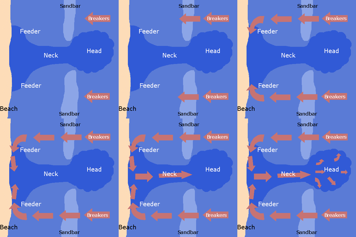
Rip currents are another coastal phenomenon related to longshore currents. Rip currents occur in the nearshore seafloor when wave trains come straight onto the shoreline. In areas where wave trains push water directly toward the beach face or where the shape of the nearshore seafloor refracts waves toward a specific point on the beach, the water piles up on shore. But this water must find an outlet back to the sea. The outlet is relatively narrow, and rip currents carry the water directly away from the beach. Swimmers caught in rip currents are carried out to sea. Swimming back to shore directly against the strong current is fruitless. A solution for good swimmers is to ride out the current to where it dissipates, swim around it, and return to the beach. Another solution for average swimmers is to swim parallel to the beach until out of the current, then return to the beach. Where rip currents are known to exist, warning signs are often posted. The best solution is to understand the nature of rip currents, have a plan before entering the water, or watch the signs and avoid them all together.

Like rip currents, undertow is a current that moves away from the shore. However, unlike rip currents, undertow occurs underneath the approaching waves and is strongest in the surf zone where waves are high and water is shallow. Undertow is another return flow for water transported onshore by waves.
Emergent and Submergent Coasts
Emergent coasts occur where sea levels fall relative to land level. Submergent coasts occur where sea levels rise relative to land level. Tectonic shifts and sea level changes cause the long-term rise and fall of sea level relative to land. Some features associated with emergent coasts include high cliffs, headlands, exposed bedrock, steep slopes, rocky shores, arches, stacks, tombolos, wave-cut platforms, and wave notches.
In emergent coasts, wave energy, wind, and gravity erode the coastline. The erosional features are elevated relative to the wave zone. Sea cliffs are persistent features as waves cut away at their base and higher rocks calve off by mass wasting. Refracted waves that attack bedrock at the base of headlands may erode or carve out a sea arch, which can extend below sea level in a sea cave. When a sea arch collapses, it leaves one or more rock columns called stacks.

A stack or near shore island creates a quiet water zone behind it. Sand moving in the longshore drift accumulates in this quiet zone forming a tombolo: a sand strip that connects the island or stack to the shoreline.

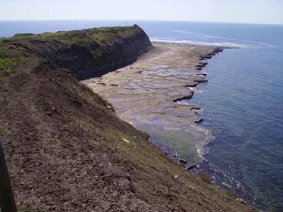
Where sand supply is low, wave energy may erode a wave-cut platform across the surf zone, exposed as bare rock with tidal pools at low tide. This bench-like terrace extends to the cliff’s base. When wave energy cuts into the base of a sea cliff, it creates a wave notch.

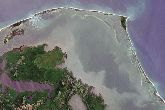
Submergent coasts occur where sea levels rise relative to land. This may be due to tectonic subsidence—when the Earth’s crust sinks—or when sea levels rise due to glacier melt. Features associated with submergent coasts include flooded river mouths, fjords, barrier islands, lagoons, estuaries, bays, tidal flats, and tidal currents. In submergent coastlines, river mouths are flooded by the rising water, for example Chesapeake Bay. Fjords are glacial valleys flooded by post-ice age sea level rise. Barrier islands are elongated bodies of sand that formed from old beach sands that used to parallel the shoreline. Often, lagoons lie behind barrier islands. [3]. Barrier island formation is controversial: some scientists believe that they formed when ice sheets melted after the last ice age, raising sea levels. Another hypothesis is that barrier islands formed from spits and bars accumulating far offshore.

Tidal flats or mudflats form where tides alternately flood and expose low areas along the coast. Combinations of symmetrical ripple marks, asymmetrical ripple marks from tidal currents, and mud cracks from drying form on these flats. Typically tidal flats are broken into three different sections, which may be abundant or absent in each individual tidal flat. Barren zones are areas with strong, flowing water and coarser sediment, with ripple marks and cross-bedding common. Marshes are vegetated and typically have sand and mud. Salt pans are the finest-grained parts of the tidal flats, with silty sediment, mud cracks, and are less often submerged [4].

Lagoons are locations where spits, barrier islands, or other features have partially cut off a body of water from the ocean. Estuaries are a vegetated type of lagoon where freshwater is flowing into the area, making the water brackish (between salt and freshwater). However, terms like a lagoon, estuary, and even bay are often loosely used in place of one another [5]. Lagoons and estuaries are certainly transitional between terrestrial and marine environments, where littoral, lacustrine (lakes or lagoons), and fluvial processes can overlap.

Human Impact on Coastal Beaches
Humans impact coastal beaches when they build homes, condominiums, hotels, businesses, and harbors—and then again when they try to manage the natural processes of erosion. Waves, currents, longshore drift, and dams at river mouths deplete sand from expensive beachfront property and expose once calm harbors to high-wave energy. To protect their investment, keep sand on their beach, and maintain calm harbors, cities and landowners find ways to mitigate the damage by building jetties, groins, dams, and breakwaters.
Jetties are large manmade piles of boulders or concrete barriers built at river mouths and harbors. A jetty is designed to divert the current or tide, to keep a channel to the ocean open, and to protect a harbor or beach from wave action. Groins (also spelled groyne) are similar but smaller than jetties. Groins are fences of wire, wood or concrete built across the beach perpendicular to the shoreline and downstream of a property. Unlike jetties, groins are used to preserve sand on a beach rather than to divert it. Sand erodes on the downstream side of the groin and collects against the upstream side. Every groin on one property thus creates a need for another one on the property downstream. A series of groins along a beach develops a scalloped appearance along the shoreline.
![Source: By Archer0630 (Own work) [<a data-cke-saved-href="http://creativecommons.org/licenses/by-sa/3.0" href="http://creativecommons.org/licenses/by-sa/3.0 CC BY-SA 3.0], via Wikimedia Commons The sediment piled on one side and removed from the other.](https://geo.libretexts.org/@api/deki/files/33214/Groin_effect-300x240.jpg?revision=1&size=bestfit&width=321&height=257)
Inland streams and rivers flow to the ocean carrying sand to the longshore current which distributes it to beaches. When dams are built, they trap sand and keep sediment from reaching beaches. To replenish beaches, sand may be hauled in from other areas by trucks or barges and dumped on the depleted beach. Unfortunately, this can disrupt the ecosystem that exists along the shoreline by exposing native creatures to foreign ecosystems and microorganisms and by introducing foreign objects to humans. For example, visitors to one replenished east coast beach found munitions and metal shards in the sand, which had been dredged from abandoned military test ranges [6].

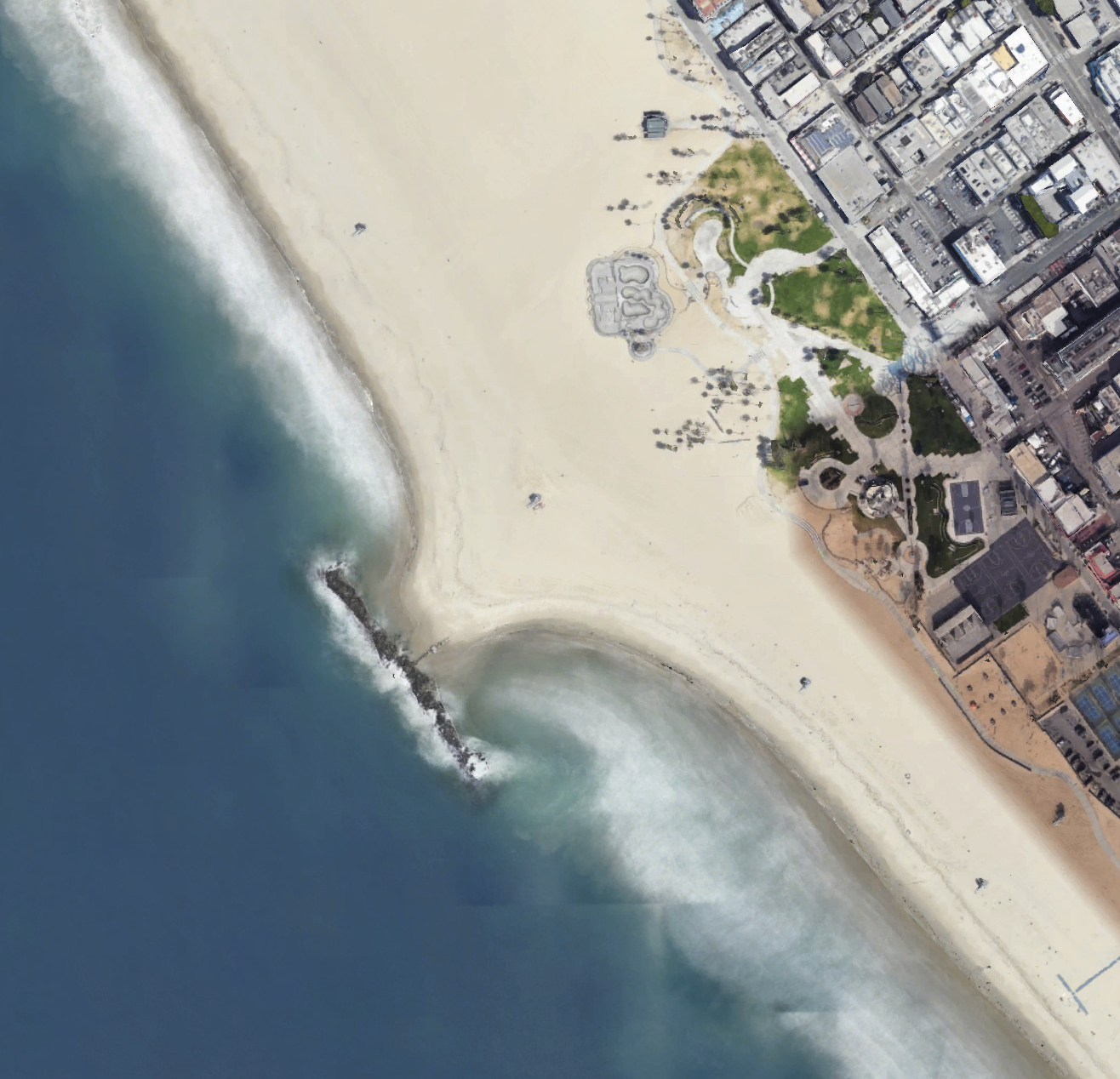
Another approach to reduce erosion or provide protected areas for boat anchoring is the construction of a breakwater, an offshore structure against which the waves break, leaving calmer waters behind it. Unfortunately, this means that waves can no longer reach the beach to keep the longshore drift of sand moving. The drift is interrupted, the sand is deposited in the quieter water, and the shoreline builds out forming a tombolo behind the breakwater, eventually covering the structure with sand [7]. The image shows this result at the breakwater constructed by the city of Venice, California in an attempt to create a quiet water harbor. The tombolo behind the breakwater is now acting as a large groin in the beach drift.

Submarine Canyons
Submarine canyons are narrow, deep underwater canyons located on continental shelves. Submarine canyons typically form at the mouths of large landward river systems. They form when rivers cut down into the continental shelf during low sea level and when material continually slumps or flows down from the mouth of a river or a delta. Underwater currents rich in sediment and more dense than sea water, can flow down the canyons, even erode and deepen them, then drain onto the ocean floor. Underwater landslides, called turbidity flows, occur when steep delta faces and underwater sediment flows are released down the continental slope. Turbidity flows in submarine canyons can continue to erode the canyon, and eventually, fan-shaped deposits develop at the mouth of the canyon on the continental rise. [8].
![Source: By United States Geological Survey ([1]) [Public domain], <a data-cke-saved-href="https://commons.wikimedia.org/wiki/File%3ACanyons_off_LA.jpg" href="https://commons.wikimedia.org/wiki/File%3ACanyons_off_LA.jpg via Wikimedia Commons The canyons are carved into the slope.](https://geo.libretexts.org/@api/deki/files/33215/Canyons_off_LA-300x213.jpg?revision=1&size=bestfit&width=346&height=246)


