
8.12: Earth's Atmospheric Circulation System
- Page ID
- 10273

\( \newcommand{\vecs}[1]{\overset { \scriptstyle \rightharpoonup} {\mathbf{#1}} } \)
\( \newcommand{\vecd}[1]{\overset{-\!-\!\rightharpoonup}{\vphantom{a}\smash {#1}}} \)
\( \newcommand{\dsum}{\displaystyle\sum\limits} \)
\( \newcommand{\dint}{\displaystyle\int\limits} \)
\( \newcommand{\dlim}{\displaystyle\lim\limits} \)
\( \newcommand{\id}{\mathrm{id}}\) \( \newcommand{\Span}{\mathrm{span}}\)
( \newcommand{\kernel}{\mathrm{null}\,}\) \( \newcommand{\range}{\mathrm{range}\,}\)
\( \newcommand{\RealPart}{\mathrm{Re}}\) \( \newcommand{\ImaginaryPart}{\mathrm{Im}}\)
\( \newcommand{\Argument}{\mathrm{Arg}}\) \( \newcommand{\norm}[1]{\| #1 \|}\)
\( \newcommand{\inner}[2]{\langle #1, #2 \rangle}\)
\( \newcommand{\Span}{\mathrm{span}}\)
\( \newcommand{\id}{\mathrm{id}}\)
\( \newcommand{\Span}{\mathrm{span}}\)
\( \newcommand{\kernel}{\mathrm{null}\,}\)
\( \newcommand{\range}{\mathrm{range}\,}\)
\( \newcommand{\RealPart}{\mathrm{Re}}\)
\( \newcommand{\ImaginaryPart}{\mathrm{Im}}\)
\( \newcommand{\Argument}{\mathrm{Arg}}\)
\( \newcommand{\norm}[1]{\| #1 \|}\)
\( \newcommand{\inner}[2]{\langle #1, #2 \rangle}\)
\( \newcommand{\Span}{\mathrm{span}}\) \( \newcommand{\AA}{\unicode[.8,0]{x212B}}\)
\( \newcommand{\vectorA}[1]{\vec{#1}} % arrow\)
\( \newcommand{\vectorAt}[1]{\vec{\text{#1}}} % arrow\)
\( \newcommand{\vectorB}[1]{\overset { \scriptstyle \rightharpoonup} {\mathbf{#1}} } \)
\( \newcommand{\vectorC}[1]{\textbf{#1}} \)
\( \newcommand{\vectorD}[1]{\overrightarrow{#1}} \)
\( \newcommand{\vectorDt}[1]{\overrightarrow{\text{#1}}} \)
\( \newcommand{\vectE}[1]{\overset{-\!-\!\rightharpoonup}{\vphantom{a}\smash{\mathbf {#1}}}} \)
\( \newcommand{\vecs}[1]{\overset { \scriptstyle \rightharpoonup} {\mathbf{#1}} } \)
\(\newcommand{\longvect}{\overrightarrow}\)
\( \newcommand{\vecd}[1]{\overset{-\!-\!\rightharpoonup}{\vphantom{a}\smash {#1}}} \)
\(\newcommand{\avec}{\mathbf a}\) \(\newcommand{\bvec}{\mathbf b}\) \(\newcommand{\cvec}{\mathbf c}\) \(\newcommand{\dvec}{\mathbf d}\) \(\newcommand{\dtil}{\widetilde{\mathbf d}}\) \(\newcommand{\evec}{\mathbf e}\) \(\newcommand{\fvec}{\mathbf f}\) \(\newcommand{\nvec}{\mathbf n}\) \(\newcommand{\pvec}{\mathbf p}\) \(\newcommand{\qvec}{\mathbf q}\) \(\newcommand{\svec}{\mathbf s}\) \(\newcommand{\tvec}{\mathbf t}\) \(\newcommand{\uvec}{\mathbf u}\) \(\newcommand{\vvec}{\mathbf v}\) \(\newcommand{\wvec}{\mathbf w}\) \(\newcommand{\xvec}{\mathbf x}\) \(\newcommand{\yvec}{\mathbf y}\) \(\newcommand{\zvec}{\mathbf z}\) \(\newcommand{\rvec}{\mathbf r}\) \(\newcommand{\mvec}{\mathbf m}\) \(\newcommand{\zerovec}{\mathbf 0}\) \(\newcommand{\onevec}{\mathbf 1}\) \(\newcommand{\real}{\mathbb R}\) \(\newcommand{\twovec}[2]{\left[\begin{array}{r}#1 \\ #2 \end{array}\right]}\) \(\newcommand{\ctwovec}[2]{\left[\begin{array}{c}#1 \\ #2 \end{array}\right]}\) \(\newcommand{\threevec}[3]{\left[\begin{array}{r}#1 \\ #2 \\ #3 \end{array}\right]}\) \(\newcommand{\cthreevec}[3]{\left[\begin{array}{c}#1 \\ #2 \\ #3 \end{array}\right]}\) \(\newcommand{\fourvec}[4]{\left[\begin{array}{r}#1 \\ #2 \\ #3 \\ #4 \end{array}\right]}\) \(\newcommand{\cfourvec}[4]{\left[\begin{array}{c}#1 \\ #2 \\ #3 \\ #4 \end{array}\right]}\) \(\newcommand{\fivevec}[5]{\left[\begin{array}{r}#1 \\ #2 \\ #3 \\ #4 \\ #5 \\ \end{array}\right]}\) \(\newcommand{\cfivevec}[5]{\left[\begin{array}{c}#1 \\ #2 \\ #3 \\ #4 \\ #5 \\ \end{array}\right]}\) \(\newcommand{\mattwo}[4]{\left[\begin{array}{rr}#1 \amp #2 \\ #3 \amp #4 \\ \end{array}\right]}\) \(\newcommand{\laspan}[1]{\text{Span}\{#1\}}\) \(\newcommand{\bcal}{\cal B}\) \(\newcommand{\ccal}{\cal C}\) \(\newcommand{\scal}{\cal S}\) \(\newcommand{\wcal}{\cal W}\) \(\newcommand{\ecal}{\cal E}\) \(\newcommand{\coords}[2]{\left\{#1\right\}_{#2}}\) \(\newcommand{\gray}[1]{\color{gray}{#1}}\) \(\newcommand{\lgray}[1]{\color{lightgray}{#1}}\) \(\newcommand{\rank}{\operatorname{rank}}\) \(\newcommand{\row}{\text{Row}}\) \(\newcommand{\col}{\text{Col}}\) \(\renewcommand{\row}{\text{Row}}\) \(\newcommand{\nul}{\text{Nul}}\) \(\newcommand{\var}{\text{Var}}\) \(\newcommand{\corr}{\text{corr}}\) \(\newcommand{\len}[1]{\left|#1\right|}\) \(\newcommand{\bbar}{\overline{\bvec}}\) \(\newcommand{\bhat}{\widehat{\bvec}}\) \(\newcommand{\bperp}{\bvec^\perp}\) \(\newcommand{\xhat}{\widehat{\xvec}}\) \(\newcommand{\vhat}{\widehat{\vvec}}\) \(\newcommand{\uhat}{\widehat{\uvec}}\) \(\newcommand{\what}{\widehat{\wvec}}\) \(\newcommand{\Sighat}{\widehat{\Sigma}}\) \(\newcommand{\lt}{<}\) \(\newcommand{\gt}{>}\) \(\newcommand{\amp}{&}\) \(\definecolor{fillinmathshade}{gray}{0.9}\)Earth's Atmospheric Circulation System
The global atmospheric circulation system influences the movement of air masses in general wind belts that move air in rotating masses within zones around the planet. These wind belts seem relatively stable when viewed in a long-term view (decades). However, fluctuations may occur on seasonal or annual basis. The wind belts are influenced by the Coriolis effect and large-scale convection patterns in the atmosphere (Figure 8.30).
These relatively stationary wind belts impact the surface of the oceans, creating currents that circulate waters in the oceans.
Studies of the atmosphere have show that their are 3 major atmospheric systems called circulation cells (Figures 8-30 and 8-31).
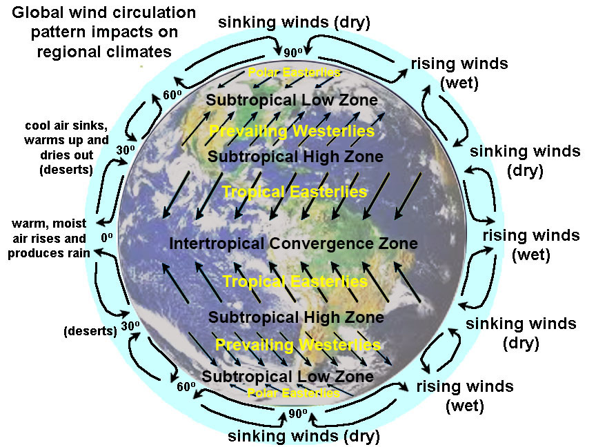
Figure 8.30. Global wind circulation patterns impact regional climates and drive the large current systems in the global ocean circulation system.
Circulation Cells in Earth's Atmosphere
Three major circulation cells move air, heat, and moisture through the atmosphere between the equatorial regions to the polar regions. These cells are constantly changing due to regional air pressure changes under the influence of the Coriolis effect.
Hadley cells (0° to 30° N and S of equator)
• Responsible for the Trade Winds: They blow NE in N. Hemisphere and SE in S. Hemisphere.
Ferrel cells (30° to 60° N and S of equator)
• Responsible for the Prevailing Westerlies in both hemispheres.
Polar cells (60° to 90° N and S)
• Responsible for the Polar Easterlies in both hemispheres.
What is the Jet Stream?
A jet stream is a narrow, variable band of very strong winds in the upper troposphere. They are predominantly westerly air currents encircling the globe several miles above the Earth. There are typically two or three jet streams in each of the northern and southern hemispheres. These high-speed wind currents often move at speeds exceeding 250 miles (400 km) per hour at altitudes of 6 to 9 miles (10 to 15 km). Jet streams are influenced by moving air masses and the Coriolis effect causing them to meander and sometime split. See the location of the jet streams in Figures 8-31 and 8-32.
 |
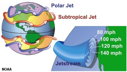 |
| Figure 8.31. Hadley, Ferrel, and Polar circulation cells in Earth's atmosphere redistribute convectional heat. | Figure 8.32. Polar and Subtropical jet streams |
Equatorial Doldrums and Inter-Tropical Convergence Zone (ITCZ)
The equatorial doldrums are associated with the inter-tropical convergence zone (ITCZ) the region that circles the Earth near the equator, where the trade winds of the Northern and Southern Hemispheres converge (Figure 8.33).
The doldrums are:
• Area of low atmospheric pressure with lots of rain.
• Located on equator where there is least influence of the Coriolis effect.
• Low wind area with calms, sudden storms, and light unpredictable winds
Seasonal shifts in the location of the ITCZ affects rainfall in many equatorial regions, resulting in the wet and dry seasons of the tropics rather than the cold and warm seasons of higher latitudes. The ITCZ moves north during winter in the northern hemisphere and south in the summer.

Figure 8.33. The doldrums are the belt of clouds along inter-tropical convergence zone. This belt of clouds (with lots of rain) migrates north and south across the equator with the seasons.
The Tropical Easterlies (Trade Winds)
During the age of sailing ships, ship captains learned take advantage of the prevailing wind belts to cross the oceans. Two belts of trade winds encircle the Earth, blowing from the tropical high-pressure belts (Hadley Cells) to the low-pressure zone of the equatorial inter-tropical convergence zone. The tropical easterly wind belts near the equatorial region are also called the Trade Winds. Trade winds blow steadily toward the equator from the northeast in the Northern Hemisphere, or the southeast in the Southern Hemisphere (see Figures 8-30 and 8-31).
Horse Latitudes
The horse latitudes are belts of calm air and sea occurring in both the northern and southern hemispheres between the trade winds and the westerlies (roughly 30-38 degrees north and south of the equator). Horse latitudes separate the Hadley and Ferrel Cells. It is a region also called the subtropical high—a belt of very dry because of high pressure, little rain. Horse latitudes roughly correspond with major desert regions of the world. The horse latitudes got it name from historic legends describe ships becoming becalmed when crossing the horse latitudes and running out of water and unable to re supply. Sailors would throw horses on the ships overboard.
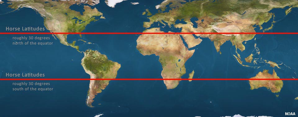
Figure 8.34. Location of the horse latitudes (subtropical highs).
Weather data animations:
Global atmospheric circulation video - High Speed Weather—Satellite Infrared of the entire globe (NASA data)
See animations current data from NASA Global Geostationary Weather Satellite (GOES weather satellite).
Current San Diego Weather Radar (accuweather.com) - this website provides current weather radar conditions for local, state, regional, and national scales with looping animations.
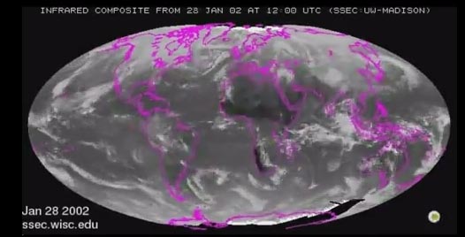
Figure 8.35. Weather satellite data animation.