
5.9: Deep-Ocean Basins
- Page ID
- 9897

\( \newcommand{\vecs}[1]{\overset { \scriptstyle \rightharpoonup} {\mathbf{#1}} } \)
\( \newcommand{\vecd}[1]{\overset{-\!-\!\rightharpoonup}{\vphantom{a}\smash {#1}}} \)
\( \newcommand{\dsum}{\displaystyle\sum\limits} \)
\( \newcommand{\dint}{\displaystyle\int\limits} \)
\( \newcommand{\dlim}{\displaystyle\lim\limits} \)
\( \newcommand{\id}{\mathrm{id}}\) \( \newcommand{\Span}{\mathrm{span}}\)
( \newcommand{\kernel}{\mathrm{null}\,}\) \( \newcommand{\range}{\mathrm{range}\,}\)
\( \newcommand{\RealPart}{\mathrm{Re}}\) \( \newcommand{\ImaginaryPart}{\mathrm{Im}}\)
\( \newcommand{\Argument}{\mathrm{Arg}}\) \( \newcommand{\norm}[1]{\| #1 \|}\)
\( \newcommand{\inner}[2]{\langle #1, #2 \rangle}\)
\( \newcommand{\Span}{\mathrm{span}}\)
\( \newcommand{\id}{\mathrm{id}}\)
\( \newcommand{\Span}{\mathrm{span}}\)
\( \newcommand{\kernel}{\mathrm{null}\,}\)
\( \newcommand{\range}{\mathrm{range}\,}\)
\( \newcommand{\RealPart}{\mathrm{Re}}\)
\( \newcommand{\ImaginaryPart}{\mathrm{Im}}\)
\( \newcommand{\Argument}{\mathrm{Arg}}\)
\( \newcommand{\norm}[1]{\| #1 \|}\)
\( \newcommand{\inner}[2]{\langle #1, #2 \rangle}\)
\( \newcommand{\Span}{\mathrm{span}}\) \( \newcommand{\AA}{\unicode[.8,0]{x212B}}\)
\( \newcommand{\vectorA}[1]{\vec{#1}} % arrow\)
\( \newcommand{\vectorAt}[1]{\vec{\text{#1}}} % arrow\)
\( \newcommand{\vectorB}[1]{\overset { \scriptstyle \rightharpoonup} {\mathbf{#1}} } \)
\( \newcommand{\vectorC}[1]{\textbf{#1}} \)
\( \newcommand{\vectorD}[1]{\overrightarrow{#1}} \)
\( \newcommand{\vectorDt}[1]{\overrightarrow{\text{#1}}} \)
\( \newcommand{\vectE}[1]{\overset{-\!-\!\rightharpoonup}{\vphantom{a}\smash{\mathbf {#1}}}} \)
\( \newcommand{\vecs}[1]{\overset { \scriptstyle \rightharpoonup} {\mathbf{#1}} } \)
\(\newcommand{\longvect}{\overrightarrow}\)
\( \newcommand{\vecd}[1]{\overset{-\!-\!\rightharpoonup}{\vphantom{a}\smash {#1}}} \)
\(\newcommand{\avec}{\mathbf a}\) \(\newcommand{\bvec}{\mathbf b}\) \(\newcommand{\cvec}{\mathbf c}\) \(\newcommand{\dvec}{\mathbf d}\) \(\newcommand{\dtil}{\widetilde{\mathbf d}}\) \(\newcommand{\evec}{\mathbf e}\) \(\newcommand{\fvec}{\mathbf f}\) \(\newcommand{\nvec}{\mathbf n}\) \(\newcommand{\pvec}{\mathbf p}\) \(\newcommand{\qvec}{\mathbf q}\) \(\newcommand{\svec}{\mathbf s}\) \(\newcommand{\tvec}{\mathbf t}\) \(\newcommand{\uvec}{\mathbf u}\) \(\newcommand{\vvec}{\mathbf v}\) \(\newcommand{\wvec}{\mathbf w}\) \(\newcommand{\xvec}{\mathbf x}\) \(\newcommand{\yvec}{\mathbf y}\) \(\newcommand{\zvec}{\mathbf z}\) \(\newcommand{\rvec}{\mathbf r}\) \(\newcommand{\mvec}{\mathbf m}\) \(\newcommand{\zerovec}{\mathbf 0}\) \(\newcommand{\onevec}{\mathbf 1}\) \(\newcommand{\real}{\mathbb R}\) \(\newcommand{\twovec}[2]{\left[\begin{array}{r}#1 \\ #2 \end{array}\right]}\) \(\newcommand{\ctwovec}[2]{\left[\begin{array}{c}#1 \\ #2 \end{array}\right]}\) \(\newcommand{\threevec}[3]{\left[\begin{array}{r}#1 \\ #2 \\ #3 \end{array}\right]}\) \(\newcommand{\cthreevec}[3]{\left[\begin{array}{c}#1 \\ #2 \\ #3 \end{array}\right]}\) \(\newcommand{\fourvec}[4]{\left[\begin{array}{r}#1 \\ #2 \\ #3 \\ #4 \end{array}\right]}\) \(\newcommand{\cfourvec}[4]{\left[\begin{array}{c}#1 \\ #2 \\ #3 \\ #4 \end{array}\right]}\) \(\newcommand{\fivevec}[5]{\left[\begin{array}{r}#1 \\ #2 \\ #3 \\ #4 \\ #5 \\ \end{array}\right]}\) \(\newcommand{\cfivevec}[5]{\left[\begin{array}{c}#1 \\ #2 \\ #3 \\ #4 \\ #5 \\ \end{array}\right]}\) \(\newcommand{\mattwo}[4]{\left[\begin{array}{rr}#1 \amp #2 \\ #3 \amp #4 \\ \end{array}\right]}\) \(\newcommand{\laspan}[1]{\text{Span}\{#1\}}\) \(\newcommand{\bcal}{\cal B}\) \(\newcommand{\ccal}{\cal C}\) \(\newcommand{\scal}{\cal S}\) \(\newcommand{\wcal}{\cal W}\) \(\newcommand{\ecal}{\cal E}\) \(\newcommand{\coords}[2]{\left\{#1\right\}_{#2}}\) \(\newcommand{\gray}[1]{\color{gray}{#1}}\) \(\newcommand{\lgray}[1]{\color{lightgray}{#1}}\) \(\newcommand{\rank}{\operatorname{rank}}\) \(\newcommand{\row}{\text{Row}}\) \(\newcommand{\col}{\text{Col}}\) \(\renewcommand{\row}{\text{Row}}\) \(\newcommand{\nul}{\text{Nul}}\) \(\newcommand{\var}{\text{Var}}\) \(\newcommand{\corr}{\text{corr}}\) \(\newcommand{\len}[1]{\left|#1\right|}\) \(\newcommand{\bbar}{\overline{\bvec}}\) \(\newcommand{\bhat}{\widehat{\bvec}}\) \(\newcommand{\bperp}{\bvec^\perp}\) \(\newcommand{\xhat}{\widehat{\xvec}}\) \(\newcommand{\vhat}{\widehat{\vvec}}\) \(\newcommand{\uhat}{\widehat{\uvec}}\) \(\newcommand{\what}{\widehat{\wvec}}\) \(\newcommand{\Sighat}{\widehat{\Sigma}}\) \(\newcommand{\lt}{<}\) \(\newcommand{\gt}{>}\) \(\newcommand{\amp}{&}\) \(\definecolor{fillinmathshade}{gray}{0.9}\)Deep-Ocean Basins
Deep-ocean basins cover the greatest portion of the Earth's surface. Geographic features associated with deep-ocean basins include trenches, abyssal plains, ocean ridges and rises, and submarine mountainous regions.
Trenches
Trenches are long, relatively narrow canyon-like features that run parallel to continental margins. They are the deepest parts of ocean basins. Most trenches are located in the Pacific Ocean.
Trenches occur where mobile lithospheric plates plunge into the mantle (subduction zones). Trenches are associated with intense volcanic activity, usually in the form of volcanic arcs (or volcanic island chains) that develop above the descending side of the subducting plate associated with a trench.
Abyssal Plains
An abyssal plain is an underwater plain on the deep ocean floor, usually found at depths between 4500 and 6000 meters that extends from the continental rise (continental Lithogenous sediments accumulate along continental margins) to the distant deep ocean basin where continental-derived sediment deposition is not significant. Abyssal plains are large horizontal seafloor regions - typically some of the flattest places on the Earth's surface.
Abyssal plains are underlain by oceanic crust that formed and moved away from spreading centers associated with mid-ocean ridges and rises. Because they are so far from land they have very slow sedimentation rates. Some places less than 1 cm per 1000 years. The dominant geologic process is "Planktonic rain" which blankets seafloor with organic sediments.
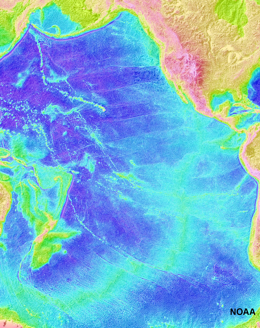
Figure 5.17. Abyssal plains dominate the Pacific Ocean basin.
Seamounts, Islands, Atolls, and Guyots
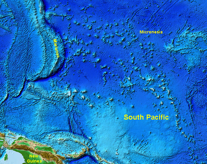
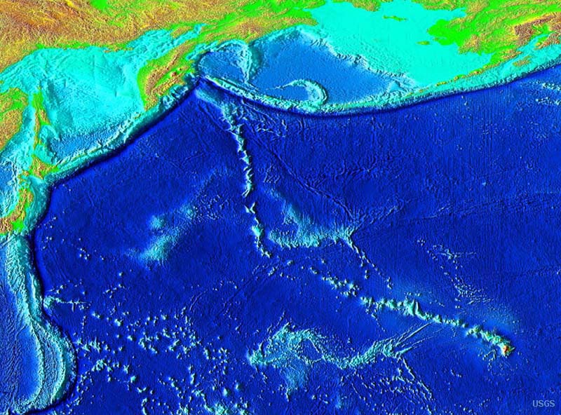
A seamount is any isolated mountain-sized feature that rises above the seafloor. A seamount may be a large tectonic block that separated from a large continental landmass or may be an ancient or even active submarine volcano. A submarine mountain that is partly exposed above the ocean surface is called an island. Many seamounts (and islands) are isolated volcanic peaks rising off seafloor. Many are part of mid-oceanic ridges or associated with oceanic hotspots (discussed below). For instance, the Hawaiian Islands are part of the Emperor Seamount Chain (see Figure 5.7). The South Pacific region is a region with numerous seamounts, of which many are islands, atolls, or guyots (Figure 5.40).

Figure 5.18. Formation of ocean-basin volcanoes, atolls, and guyots. Guyots are flat-topped seamounts that have sunk deep enough into cold water so that reefs cannot form.
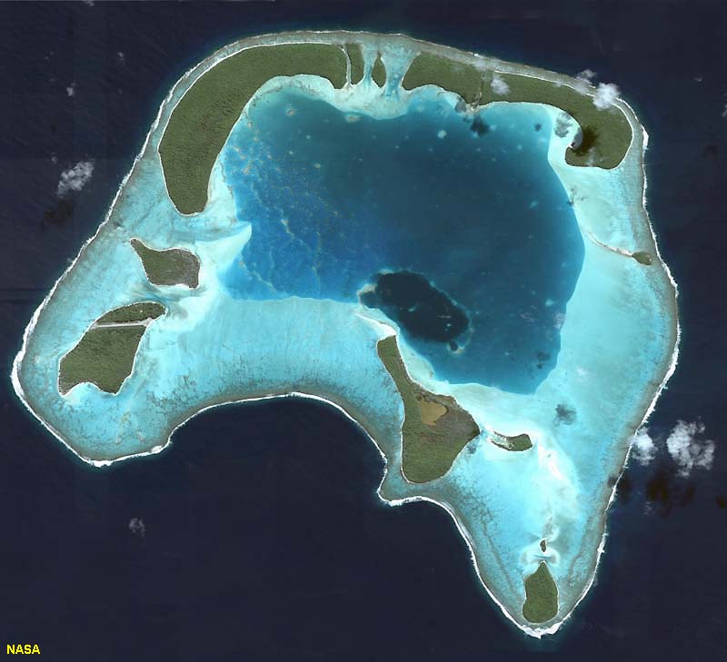
An atoll is a ring-shaped reef, island, or chain of islands formed of coral, typical on a foundation of an extinct volcano in the ocean. The limestone ring forms along the margins of the volcano. Over time, the volcano either erodes away or sinks below the surface, but the limestone rim continues to grow and expand over time. A guyot is a submarine mountain (seamount) with a flat top. Most guyots are ancient submarine volcanoes that have been beveled by wave action before sinking into ocean depth and may lack the fringing limestone reefs associated with atolls.
 |
 |
 |
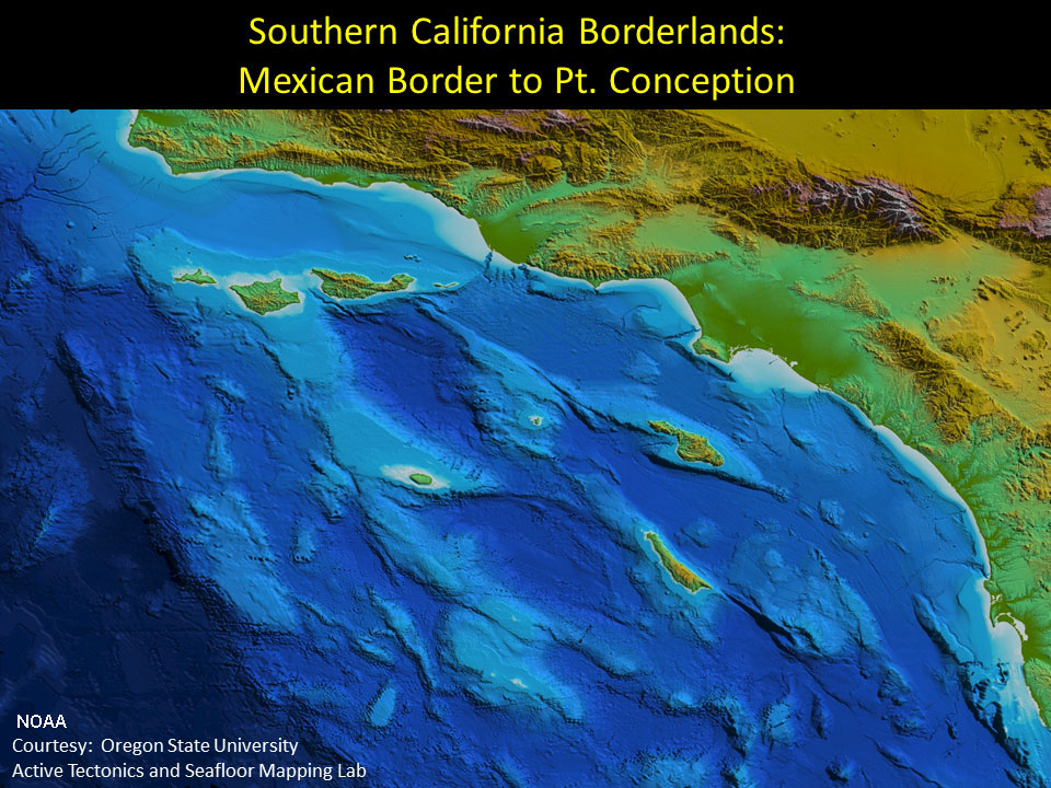 |
| Figure 5.19. The South Pacific region has numerous islands, seamounts, atolls, and guyots. All of them started forming as undersea volcanoes. | Figure 5.20. Hawaii is the youngest volcanic island of the Emperor Seamount Chain. Many of the older seamounts were once volcanic islands but are now atolls or guyots. | Figure 5.21. A satellite view of an atoll displaying a fringing carbonate reef platform (with islands) surrounding an eroding central volcanic peak. Most atolls of the world are located in tropical regions of the South Pacific and Indian Oceans. | Figure 5.22. Seamounts and islands offshore of southern California. Many of these features are associated with active faults that are moving great blocks of crust across the seafloor. |
Oceanic (Mid-Ocean) Ridges and Rises
Mid-ocean ridges (MORs) are broad, linear swells along divergent plate boundaries in ocean basins. They are associated with extensive faulting and small earthquakes, and along their crest there is high heat flow form new crust forming from the cooling of molten material derived from the mantle and remelting of the crust. Ocean Ridges are present in all ocean basins. They are the shallowest and youngest parts of deep ocean basins. Features associated with ocean ridges include volcanism (undersea volcanic features), hydrothermal vents, and undersea rift valley. As newly formed crust moves away from spreading centers, the crust gets older and layers of sediments thicken away from the mid-ocean ridges.
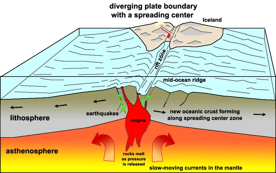
Figure 5.23. Formation of new oceanic crust along a spreading center associated with a mid-ocean ridge. Some spreading centers appear on land. For example, a portion of the Mid-Atlantic Ridge is exposed as Iceland.
What is the difference between a mid-ocean ridge and a mid-ocean rise?
The two features are basically the same except for their shape (topography) and how fast they form.
Topographic differences are controlled by spreading rates
• Ridges are steeper with slow spreading rates (1-5 centimeters per year) - Example: Mid-Atlantic Ridge
• Rises are flatter with fast spreading rates (greater than 9 centimeters per year) - Example: East Pacific Rise
Why are ridges and rises so high?
• Newly created oceanic lithosphere is hot and occupies more volume (less dense) than cooler older rocks
• As the oceanic crust travels away from the ridge crest it cools and becomes more dense and sinks
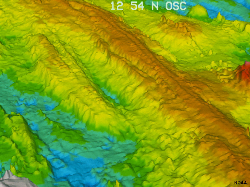
Figure 5.24. Bathymetric image of the spreading center on the East Pacific Rise.