
3.21: Quiz Questions - Chapter 3 - Structure of the Earth
- Page ID
- 9846

\( \newcommand{\vecs}[1]{\overset { \scriptstyle \rightharpoonup} {\mathbf{#1}} } \)
\( \newcommand{\vecd}[1]{\overset{-\!-\!\rightharpoonup}{\vphantom{a}\smash {#1}}} \)
\( \newcommand{\id}{\mathrm{id}}\) \( \newcommand{\Span}{\mathrm{span}}\)
( \newcommand{\kernel}{\mathrm{null}\,}\) \( \newcommand{\range}{\mathrm{range}\,}\)
\( \newcommand{\RealPart}{\mathrm{Re}}\) \( \newcommand{\ImaginaryPart}{\mathrm{Im}}\)
\( \newcommand{\Argument}{\mathrm{Arg}}\) \( \newcommand{\norm}[1]{\| #1 \|}\)
\( \newcommand{\inner}[2]{\langle #1, #2 \rangle}\)
\( \newcommand{\Span}{\mathrm{span}}\)
\( \newcommand{\id}{\mathrm{id}}\)
\( \newcommand{\Span}{\mathrm{span}}\)
\( \newcommand{\kernel}{\mathrm{null}\,}\)
\( \newcommand{\range}{\mathrm{range}\,}\)
\( \newcommand{\RealPart}{\mathrm{Re}}\)
\( \newcommand{\ImaginaryPart}{\mathrm{Im}}\)
\( \newcommand{\Argument}{\mathrm{Arg}}\)
\( \newcommand{\norm}[1]{\| #1 \|}\)
\( \newcommand{\inner}[2]{\langle #1, #2 \rangle}\)
\( \newcommand{\Span}{\mathrm{span}}\) \( \newcommand{\AA}{\unicode[.8,0]{x212B}}\)
\( \newcommand{\vectorA}[1]{\vec{#1}} % arrow\)
\( \newcommand{\vectorAt}[1]{\vec{\text{#1}}} % arrow\)
\( \newcommand{\vectorB}[1]{\overset { \scriptstyle \rightharpoonup} {\mathbf{#1}} } \)
\( \newcommand{\vectorC}[1]{\textbf{#1}} \)
\( \newcommand{\vectorD}[1]{\overrightarrow{#1}} \)
\( \newcommand{\vectorDt}[1]{\overrightarrow{\text{#1}}} \)
\( \newcommand{\vectE}[1]{\overset{-\!-\!\rightharpoonup}{\vphantom{a}\smash{\mathbf {#1}}}} \)
\( \newcommand{\vecs}[1]{\overset { \scriptstyle \rightharpoonup} {\mathbf{#1}} } \)
\( \newcommand{\vecd}[1]{\overset{-\!-\!\rightharpoonup}{\vphantom{a}\smash {#1}}} \)
\(\newcommand{\avec}{\mathbf a}\) \(\newcommand{\bvec}{\mathbf b}\) \(\newcommand{\cvec}{\mathbf c}\) \(\newcommand{\dvec}{\mathbf d}\) \(\newcommand{\dtil}{\widetilde{\mathbf d}}\) \(\newcommand{\evec}{\mathbf e}\) \(\newcommand{\fvec}{\mathbf f}\) \(\newcommand{\nvec}{\mathbf n}\) \(\newcommand{\pvec}{\mathbf p}\) \(\newcommand{\qvec}{\mathbf q}\) \(\newcommand{\svec}{\mathbf s}\) \(\newcommand{\tvec}{\mathbf t}\) \(\newcommand{\uvec}{\mathbf u}\) \(\newcommand{\vvec}{\mathbf v}\) \(\newcommand{\wvec}{\mathbf w}\) \(\newcommand{\xvec}{\mathbf x}\) \(\newcommand{\yvec}{\mathbf y}\) \(\newcommand{\zvec}{\mathbf z}\) \(\newcommand{\rvec}{\mathbf r}\) \(\newcommand{\mvec}{\mathbf m}\) \(\newcommand{\zerovec}{\mathbf 0}\) \(\newcommand{\onevec}{\mathbf 1}\) \(\newcommand{\real}{\mathbb R}\) \(\newcommand{\twovec}[2]{\left[\begin{array}{r}#1 \\ #2 \end{array}\right]}\) \(\newcommand{\ctwovec}[2]{\left[\begin{array}{c}#1 \\ #2 \end{array}\right]}\) \(\newcommand{\threevec}[3]{\left[\begin{array}{r}#1 \\ #2 \\ #3 \end{array}\right]}\) \(\newcommand{\cthreevec}[3]{\left[\begin{array}{c}#1 \\ #2 \\ #3 \end{array}\right]}\) \(\newcommand{\fourvec}[4]{\left[\begin{array}{r}#1 \\ #2 \\ #3 \\ #4 \end{array}\right]}\) \(\newcommand{\cfourvec}[4]{\left[\begin{array}{c}#1 \\ #2 \\ #3 \\ #4 \end{array}\right]}\) \(\newcommand{\fivevec}[5]{\left[\begin{array}{r}#1 \\ #2 \\ #3 \\ #4 \\ #5 \\ \end{array}\right]}\) \(\newcommand{\cfivevec}[5]{\left[\begin{array}{c}#1 \\ #2 \\ #3 \\ #4 \\ #5 \\ \end{array}\right]}\) \(\newcommand{\mattwo}[4]{\left[\begin{array}{rr}#1 \amp #2 \\ #3 \amp #4 \\ \end{array}\right]}\) \(\newcommand{\laspan}[1]{\text{Span}\{#1\}}\) \(\newcommand{\bcal}{\cal B}\) \(\newcommand{\ccal}{\cal C}\) \(\newcommand{\scal}{\cal S}\) \(\newcommand{\wcal}{\cal W}\) \(\newcommand{\ecal}{\cal E}\) \(\newcommand{\coords}[2]{\left\{#1\right\}_{#2}}\) \(\newcommand{\gray}[1]{\color{gray}{#1}}\) \(\newcommand{\lgray}[1]{\color{lightgray}{#1}}\) \(\newcommand{\rank}{\operatorname{rank}}\) \(\newcommand{\row}{\text{Row}}\) \(\newcommand{\col}{\text{Col}}\) \(\renewcommand{\row}{\text{Row}}\) \(\newcommand{\nul}{\text{Nul}}\) \(\newcommand{\var}{\text{Var}}\) \(\newcommand{\corr}{\text{corr}}\) \(\newcommand{\len}[1]{\left|#1\right|}\) \(\newcommand{\bbar}{\overline{\bvec}}\) \(\newcommand{\bhat}{\widehat{\bvec}}\) \(\newcommand{\bperp}{\bvec^\perp}\) \(\newcommand{\xhat}{\widehat{\xvec}}\) \(\newcommand{\vhat}{\widehat{\vvec}}\) \(\newcommand{\uhat}{\widehat{\uvec}}\) \(\newcommand{\what}{\widehat{\wvec}}\) \(\newcommand{\Sighat}{\widehat{\Sigma}}\) \(\newcommand{\lt}{<}\) \(\newcommand{\gt}{>}\) \(\newcommand{\amp}{&}\) \(\definecolor{fillinmathshade}{gray}{0.9}\)1. What layer of the atmosphere does all weather take place?
a. thermosphere
b. mesosphere
c. stratosphere
d. troposphere
2. The solar wind is a stream of energized, charged particles flowing outward from the the Sun's upper atmosphere (the corona). When these particles encounter the Earth's magnetic field they are deflected toward the polar region where the stream into the atmosphere causing the night sky to light up. In the southern hemisphere these light patterns in the sky are called:
a. the aurora borealis
b. a corona ejection
c. the aurora australis
d. a solar storm
3. The part of the Earth that includes all the frozen water (including glaciers, sea ice, snow, freshwater ice, and frozen ground [permafrost]) is called:
a. the asthenosphere.
b. the hydrosphere.
c. the troposphere.
d. the cryosphere.
4. The name given to the regions of the Earth occupied by living organisms is called:
a. the hydrosphere.
b. the biosphere.
c. the troposphere.
d. the mesosphere.
5. The rigid outer part of the earth, consisting of the crust and upper mantle. is a relatively cool, rigid shell and averages about 100 km in thickness and called the:
a. asthenosphere.
b. lithosphere.
c. stratosphere.
d. cryosphere.
Questions 6-9 apply to the Structure of the Earth Diagram below.
Note: layers on left are classified by chemical properties, layers on right are physical properties.
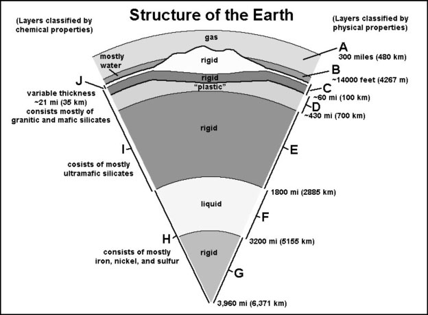
Match letters (A to J) to features on the Structure of the Earth diagram.
6. Which layer represents Earth's crust?
7. Which layer represents the lithosphere?
8. Which layer represents the asthenosphere?
9. Which layer or layers represent the core?
10. Magnetic reversals have happened many times in Earth's past. What is something we might observed if a magnetic reversal were to happen today?
a. A magnetic compass would point to the South Magnetic Pole instead of the North Magnetic Pole.
b. Earth would flip on its rotational axis.
c. Earth's magnetic field might suddenly runs east/west instead of south/north.
d. All choices are correct.
11. Studies of the alignment of iron-rich minerals in old volcanic lava flows around the world have shown that:
a. the Earth's magnetic poles may have moved.
b. the Earth's magnetic poles have switched alignment many times in the past.
c. the continents have moved over time.
d. All choices are correct.
12. On a reverse fault:
a. the hanging wall moves up relative to the foot wall.
b. the foot wall moves up relative to the hanging wall.
c. the foot wall moves horizontally relative to the hanging wall.
d. the hanging wall moves down relative to the foot wall.
13. The location below the Earth's surface where an earthquake rupture starts is called:
a. the epicenter.
b. the focus.
c. the fault line.
d. All choices are correct.
14. Which of the follow statements is NOT true?
a. An earthquake fault is an active fault that has a history of producing earthquakes.
b. Not all faults are active or are considered earthquake faults.
c. All faults are actively capable of producing earthquakes.
d. Active earthquake faults can produce both earthquakes and creep.
15. A seismograph is a device used to record earthquake shaking and is used to determine:
a. the distance from an earthquake focus.
b. the magnitude of an earthquake.
c. the intensity of an earthquake.
d. All choices are correct.
16. The first to arrive at a distant location from an earthquake is:
a. a shear (S) wave.
b. a compression (P) wave.
c. a sound (S) wave.
d. a rupture.
e. none of the above.
17. The measure of ground shaking describing the local severity of an earthquake in terms of its effects on the Earth’s surface and on humans and their structures is called:
a. earthquake magnitude.
b. Richter scale.
c. earthquake intensity.
d. P-waves and S-waves.
18. What can seismic (P and S) waves data tell us?
a. Parts of the Earth's interior are not solid.
b. The depth, location, and relative strength of an earthquake.
c. The average density of each layer in the Earth.
d. All of the above.
19. The Mohorovicic discontinuity (or Moho) is:
a. the boundary between granitic continental crust and basaltic oceanic crust.
b. the boundary surface between the Earth's crust and the mantle, lying at a depth of about 6–7 miles (10–12 km) under the ocean bed and about 24–30 miles (40–50 km) under the continents.
c. the boundary between Earth’s rigid mantle and the liquid core.
d. a fault boundary between two plates in a subduction zone.
20. Isostasy allows continental crust to rise above sea level because it is:
a. thinner and denser than ocean crust.
b. mostly composed of volcanic basalt in composition compared with ocean crust.
c. thicker and contains more granitic rocks than ocean crust.
d. all of the above.
21. This extensive region that surrounds an ocean basin gets its name because experiences more major earthquakes and volcanic eruptions than other regions of the world.
a. Himalayan Mountains.
b. The Atlantic Ocean basin
c. The Arctic Ocean basin
d. The Ring of Fire
22. The theory of continental drift (a theory proposed by Alfred Wegener in 1912) was supported by what kind of evidence?
a. Matching fossils occur on different continents on opposite sides of ocean basins.
b. The shapes of continent margins on opposite sides of ocean basins appear to fit like a jigsaw puzzle.
c. Rocks of similar age and composition and mountain ranges on different continents appear to match on opposite sides of ocean basins.
d. all of the above
23. The most conclusive proof for continental drift was provided by:
a. the coastlines of continents on a world map.
b. evidence that sea-floor spreading creates new ocean crust beneath ocean basins.
c. identical fossils and rocks found on two separate continents.
d. similar climate patterns on opposite sides of ocean basins.
24. The ancient supercontinent in Alfred Wegener's continental drift hypothesis when all the continents were assembled into a single landmass was called:
a. Panthalassa.
b. Pangaea.
c. Gondwanaland.
d. Laurasia.
25. Geologic mapping of the world shows that much of the bedrock on all continental landmasses around the world range in ages that are exceedingly old (hundreds of millions to billions of years). However, the oldest rocks found in the ocean crust beneath the world’s ocean basins are:
a. about 2 million years and younger.
b. about 20 million years and younger.
c. about 200 million years and younger.
d. about 2 billion years and older.