
3.16: Historical Observations leading up to Plate Tectonics Theory
- Page ID
- 9839

\( \newcommand{\vecs}[1]{\overset { \scriptstyle \rightharpoonup} {\mathbf{#1}} } \)
\( \newcommand{\vecd}[1]{\overset{-\!-\!\rightharpoonup}{\vphantom{a}\smash {#1}}} \)
\( \newcommand{\id}{\mathrm{id}}\) \( \newcommand{\Span}{\mathrm{span}}\)
( \newcommand{\kernel}{\mathrm{null}\,}\) \( \newcommand{\range}{\mathrm{range}\,}\)
\( \newcommand{\RealPart}{\mathrm{Re}}\) \( \newcommand{\ImaginaryPart}{\mathrm{Im}}\)
\( \newcommand{\Argument}{\mathrm{Arg}}\) \( \newcommand{\norm}[1]{\| #1 \|}\)
\( \newcommand{\inner}[2]{\langle #1, #2 \rangle}\)
\( \newcommand{\Span}{\mathrm{span}}\)
\( \newcommand{\id}{\mathrm{id}}\)
\( \newcommand{\Span}{\mathrm{span}}\)
\( \newcommand{\kernel}{\mathrm{null}\,}\)
\( \newcommand{\range}{\mathrm{range}\,}\)
\( \newcommand{\RealPart}{\mathrm{Re}}\)
\( \newcommand{\ImaginaryPart}{\mathrm{Im}}\)
\( \newcommand{\Argument}{\mathrm{Arg}}\)
\( \newcommand{\norm}[1]{\| #1 \|}\)
\( \newcommand{\inner}[2]{\langle #1, #2 \rangle}\)
\( \newcommand{\Span}{\mathrm{span}}\) \( \newcommand{\AA}{\unicode[.8,0]{x212B}}\)
\( \newcommand{\vectorA}[1]{\vec{#1}} % arrow\)
\( \newcommand{\vectorAt}[1]{\vec{\text{#1}}} % arrow\)
\( \newcommand{\vectorB}[1]{\overset { \scriptstyle \rightharpoonup} {\mathbf{#1}} } \)
\( \newcommand{\vectorC}[1]{\textbf{#1}} \)
\( \newcommand{\vectorD}[1]{\overrightarrow{#1}} \)
\( \newcommand{\vectorDt}[1]{\overrightarrow{\text{#1}}} \)
\( \newcommand{\vectE}[1]{\overset{-\!-\!\rightharpoonup}{\vphantom{a}\smash{\mathbf {#1}}}} \)
\( \newcommand{\vecs}[1]{\overset { \scriptstyle \rightharpoonup} {\mathbf{#1}} } \)
\( \newcommand{\vecd}[1]{\overset{-\!-\!\rightharpoonup}{\vphantom{a}\smash {#1}}} \)
\(\newcommand{\avec}{\mathbf a}\) \(\newcommand{\bvec}{\mathbf b}\) \(\newcommand{\cvec}{\mathbf c}\) \(\newcommand{\dvec}{\mathbf d}\) \(\newcommand{\dtil}{\widetilde{\mathbf d}}\) \(\newcommand{\evec}{\mathbf e}\) \(\newcommand{\fvec}{\mathbf f}\) \(\newcommand{\nvec}{\mathbf n}\) \(\newcommand{\pvec}{\mathbf p}\) \(\newcommand{\qvec}{\mathbf q}\) \(\newcommand{\svec}{\mathbf s}\) \(\newcommand{\tvec}{\mathbf t}\) \(\newcommand{\uvec}{\mathbf u}\) \(\newcommand{\vvec}{\mathbf v}\) \(\newcommand{\wvec}{\mathbf w}\) \(\newcommand{\xvec}{\mathbf x}\) \(\newcommand{\yvec}{\mathbf y}\) \(\newcommand{\zvec}{\mathbf z}\) \(\newcommand{\rvec}{\mathbf r}\) \(\newcommand{\mvec}{\mathbf m}\) \(\newcommand{\zerovec}{\mathbf 0}\) \(\newcommand{\onevec}{\mathbf 1}\) \(\newcommand{\real}{\mathbb R}\) \(\newcommand{\twovec}[2]{\left[\begin{array}{r}#1 \\ #2 \end{array}\right]}\) \(\newcommand{\ctwovec}[2]{\left[\begin{array}{c}#1 \\ #2 \end{array}\right]}\) \(\newcommand{\threevec}[3]{\left[\begin{array}{r}#1 \\ #2 \\ #3 \end{array}\right]}\) \(\newcommand{\cthreevec}[3]{\left[\begin{array}{c}#1 \\ #2 \\ #3 \end{array}\right]}\) \(\newcommand{\fourvec}[4]{\left[\begin{array}{r}#1 \\ #2 \\ #3 \\ #4 \end{array}\right]}\) \(\newcommand{\cfourvec}[4]{\left[\begin{array}{c}#1 \\ #2 \\ #3 \\ #4 \end{array}\right]}\) \(\newcommand{\fivevec}[5]{\left[\begin{array}{r}#1 \\ #2 \\ #3 \\ #4 \\ #5 \\ \end{array}\right]}\) \(\newcommand{\cfivevec}[5]{\left[\begin{array}{c}#1 \\ #2 \\ #3 \\ #4 \\ #5 \\ \end{array}\right]}\) \(\newcommand{\mattwo}[4]{\left[\begin{array}{rr}#1 \amp #2 \\ #3 \amp #4 \\ \end{array}\right]}\) \(\newcommand{\laspan}[1]{\text{Span}\{#1\}}\) \(\newcommand{\bcal}{\cal B}\) \(\newcommand{\ccal}{\cal C}\) \(\newcommand{\scal}{\cal S}\) \(\newcommand{\wcal}{\cal W}\) \(\newcommand{\ecal}{\cal E}\) \(\newcommand{\coords}[2]{\left\{#1\right\}_{#2}}\) \(\newcommand{\gray}[1]{\color{gray}{#1}}\) \(\newcommand{\lgray}[1]{\color{lightgray}{#1}}\) \(\newcommand{\rank}{\operatorname{rank}}\) \(\newcommand{\row}{\text{Row}}\) \(\newcommand{\col}{\text{Col}}\) \(\renewcommand{\row}{\text{Row}}\) \(\newcommand{\nul}{\text{Nul}}\) \(\newcommand{\var}{\text{Var}}\) \(\newcommand{\corr}{\text{corr}}\) \(\newcommand{\len}[1]{\left|#1\right|}\) \(\newcommand{\bbar}{\overline{\bvec}}\) \(\newcommand{\bhat}{\widehat{\bvec}}\) \(\newcommand{\bperp}{\bvec^\perp}\) \(\newcommand{\xhat}{\widehat{\xvec}}\) \(\newcommand{\vhat}{\widehat{\vvec}}\) \(\newcommand{\uhat}{\widehat{\uvec}}\) \(\newcommand{\what}{\widehat{\wvec}}\) \(\newcommand{\Sighat}{\widehat{\Sigma}}\) \(\newcommand{\lt}{<}\) \(\newcommand{\gt}{>}\) \(\newcommand{\amp}{&}\) \(\definecolor{fillinmathshade}{gray}{0.9}\)Historical Observations leading up to Plate Tectonics Theory
Much of the background work related to the modern theory is the culmination of hundreds of years of world-wide exploration and geologic observations that go back several centuries. Highlights include:
* Early Maps of the World: Maps compiled by early global explorations resulted in the observation of the matching shapes of the coastlines on opposite sides of the Atlantic Ocean. These similarities were noted from early maps by by a Flemish cartographer named Abraham Ortelius in 1596 who first suggested that it looked like the continents had drifted apart. Geographers preparing maps noted that charts of land masses that the shape continents of the world fit together like a jig-saw puzzle. It took centuries before an organized effort started to analyze the data!
* Observations of the location of the world's volcanoes (maps) and lead to the recognition of the Ring of Fire (Figure 3.26). As we will see in the next chapter, the volcanoes of the Ring of Fire relate directly to Plate Tectonics Theory.
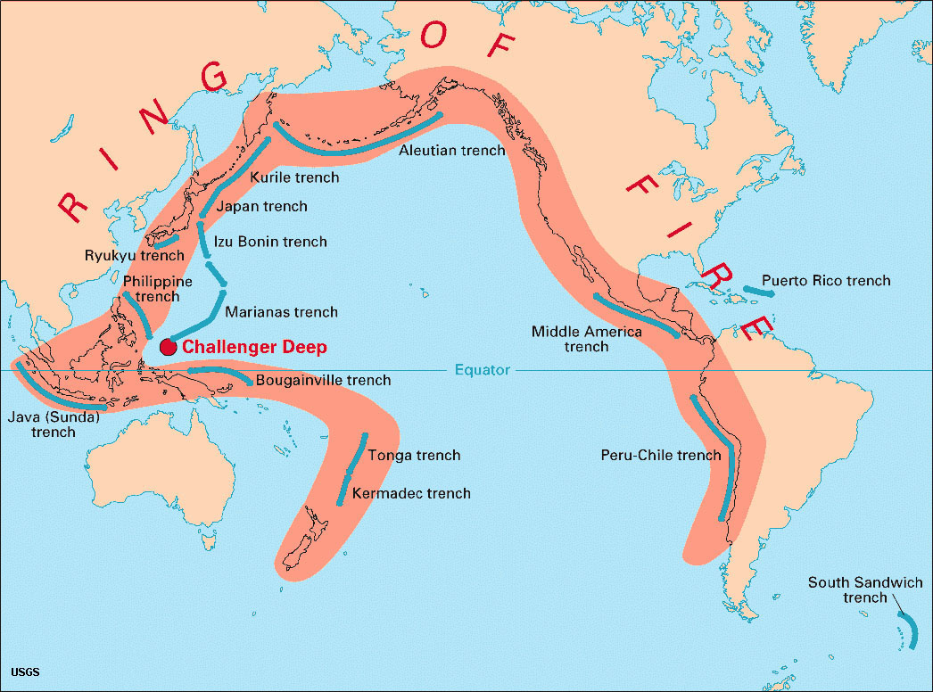
Figure 3.26. The Ring of Fire is a zone of volcanoes, numerous earthquakes, and offshore deep trenches.
Continental Drift
The Continental Drift Hypothesis was a prelude to the modern Plate Tectonics Theory.
The Continental Drift Hypothesis was proposed by a German astronomer and meteorologist named Alfred Wegener (1880-1930), but based on research by other earlier observers. The Continental Drift Hypothesis was based on observations that the continental coastlines on either side of the Atlantic Ocean seemed to match up. More importantly, the drift hypothesis was supported by similarities of fossils, rocks, and mountain belts on both sides of the Atlantic, as explained further below.
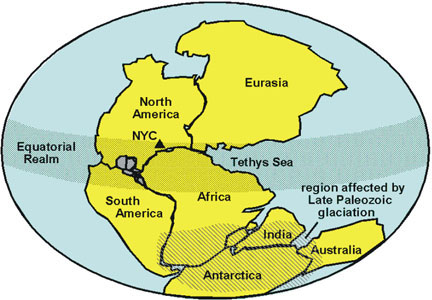
Wegener's hypothesis was that all the observable continents bordering the Atlantic and Indian Oceans had once assembled into a single supercontinent that he named Pangaea. He determined that this great landmass began to break apart about 200 million years ago (Figures 3-27 to 3-29). He said that these continents started moving about 200 million years ago (MYA) and they are still moving. This is amazing because Wegener proposed this more than 100 years ago and it remains correct today. However, the theory was rejected by most scientists at the time.
 |
 |
 |
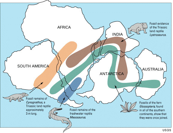
| Figure 3.27. Geographers noted that the continents fit together like a jig-saw puzzle. | Figure 3.28. Fossil evidence connecting lands of Pangaea about 260 million years ago) | Figure 3.29. The formation and breakup of Pangaea over 300 million years. |
| Pangaea—a supercontinent comprising all the continental crust of the earth, theorized to have assembled from other continental land masses in middle to late Paleozoic time. The assembled landmass, Pangaea, existed through late Paleozoic and through early Mesozoic times before the continents separated and gradually migrated into their current configuration. |
Geologic and fossil evidence indicated that some land masses which are now separated may have been together at some point in time. However, nobody could provide a mechanism for the continents to move.
| Fossil evidence supporting Continental Drift includes: |
| • Similar fossil sites occur on different continents, when Pangaea was together. Examples include Mesosaurus and Glossopteris fossils (Figure 3.28). Mesosaurus is a reptile from the Early Permian of southern Africa and South America. Glossopteris are fossilized woody plants from the Permian and Triassic Periods. |
| • Fossils and organic deposits in sedimentary rocks provide information about the geologic features, the climate, and flora and fauna for an area through geologic time. |
| • In many regions, fossils are found presently in climates and locations that could not have supported them. Example: fossil corals found in marine sediments of northern Alaska. This is because continents drifted from one climate zone to another, carrying fossils with them. |
| • Fossils show that marked divergent evolution occurred at times when the continents were split apart. This can account for the present-day distribution of plants and animals around the globe (especially marsupial mammals). |
| Geologic features supporting Continental Drift include: |
| • Old mountain ranges cross continental boundaries that are now separate but were once together. (Examples: The Appalachian Mountains in eastern US and Atlas Mountain of northwest Africa). |
| • The formation of rocks in climates that could not support those types of rocks. Example: Permian-age rocks displaying evidence of glaciation in found in southern India. |
| The Sedimentary Rock Record in many regions around the world reveals the progression of changes that took place as continental landmasses split apart. For example, When Africa pulled apart from South America the sediments reveal: • First, the land was uplifted, rifted apart, and a very large lake filled in the low region. • The rift partially opened to the ocean from the north. • Finally, it opened completely to the open ocean to the south. • This occurred between 60 and 100 million years ago. * Similar processes are occurring in the African Rift Zones and Red Sea region today! |