
3.14: Isostasy
- Page ID
- 9837

\( \newcommand{\vecs}[1]{\overset { \scriptstyle \rightharpoonup} {\mathbf{#1}} } \)
\( \newcommand{\vecd}[1]{\overset{-\!-\!\rightharpoonup}{\vphantom{a}\smash {#1}}} \)
\( \newcommand{\dsum}{\displaystyle\sum\limits} \)
\( \newcommand{\dint}{\displaystyle\int\limits} \)
\( \newcommand{\dlim}{\displaystyle\lim\limits} \)
\( \newcommand{\id}{\mathrm{id}}\) \( \newcommand{\Span}{\mathrm{span}}\)
( \newcommand{\kernel}{\mathrm{null}\,}\) \( \newcommand{\range}{\mathrm{range}\,}\)
\( \newcommand{\RealPart}{\mathrm{Re}}\) \( \newcommand{\ImaginaryPart}{\mathrm{Im}}\)
\( \newcommand{\Argument}{\mathrm{Arg}}\) \( \newcommand{\norm}[1]{\| #1 \|}\)
\( \newcommand{\inner}[2]{\langle #1, #2 \rangle}\)
\( \newcommand{\Span}{\mathrm{span}}\)
\( \newcommand{\id}{\mathrm{id}}\)
\( \newcommand{\Span}{\mathrm{span}}\)
\( \newcommand{\kernel}{\mathrm{null}\,}\)
\( \newcommand{\range}{\mathrm{range}\,}\)
\( \newcommand{\RealPart}{\mathrm{Re}}\)
\( \newcommand{\ImaginaryPart}{\mathrm{Im}}\)
\( \newcommand{\Argument}{\mathrm{Arg}}\)
\( \newcommand{\norm}[1]{\| #1 \|}\)
\( \newcommand{\inner}[2]{\langle #1, #2 \rangle}\)
\( \newcommand{\Span}{\mathrm{span}}\) \( \newcommand{\AA}{\unicode[.8,0]{x212B}}\)
\( \newcommand{\vectorA}[1]{\vec{#1}} % arrow\)
\( \newcommand{\vectorAt}[1]{\vec{\text{#1}}} % arrow\)
\( \newcommand{\vectorB}[1]{\overset { \scriptstyle \rightharpoonup} {\mathbf{#1}} } \)
\( \newcommand{\vectorC}[1]{\textbf{#1}} \)
\( \newcommand{\vectorD}[1]{\overrightarrow{#1}} \)
\( \newcommand{\vectorDt}[1]{\overrightarrow{\text{#1}}} \)
\( \newcommand{\vectE}[1]{\overset{-\!-\!\rightharpoonup}{\vphantom{a}\smash{\mathbf {#1}}}} \)
\( \newcommand{\vecs}[1]{\overset { \scriptstyle \rightharpoonup} {\mathbf{#1}} } \)
\(\newcommand{\longvect}{\overrightarrow}\)
\( \newcommand{\vecd}[1]{\overset{-\!-\!\rightharpoonup}{\vphantom{a}\smash {#1}}} \)
\(\newcommand{\avec}{\mathbf a}\) \(\newcommand{\bvec}{\mathbf b}\) \(\newcommand{\cvec}{\mathbf c}\) \(\newcommand{\dvec}{\mathbf d}\) \(\newcommand{\dtil}{\widetilde{\mathbf d}}\) \(\newcommand{\evec}{\mathbf e}\) \(\newcommand{\fvec}{\mathbf f}\) \(\newcommand{\nvec}{\mathbf n}\) \(\newcommand{\pvec}{\mathbf p}\) \(\newcommand{\qvec}{\mathbf q}\) \(\newcommand{\svec}{\mathbf s}\) \(\newcommand{\tvec}{\mathbf t}\) \(\newcommand{\uvec}{\mathbf u}\) \(\newcommand{\vvec}{\mathbf v}\) \(\newcommand{\wvec}{\mathbf w}\) \(\newcommand{\xvec}{\mathbf x}\) \(\newcommand{\yvec}{\mathbf y}\) \(\newcommand{\zvec}{\mathbf z}\) \(\newcommand{\rvec}{\mathbf r}\) \(\newcommand{\mvec}{\mathbf m}\) \(\newcommand{\zerovec}{\mathbf 0}\) \(\newcommand{\onevec}{\mathbf 1}\) \(\newcommand{\real}{\mathbb R}\) \(\newcommand{\twovec}[2]{\left[\begin{array}{r}#1 \\ #2 \end{array}\right]}\) \(\newcommand{\ctwovec}[2]{\left[\begin{array}{c}#1 \\ #2 \end{array}\right]}\) \(\newcommand{\threevec}[3]{\left[\begin{array}{r}#1 \\ #2 \\ #3 \end{array}\right]}\) \(\newcommand{\cthreevec}[3]{\left[\begin{array}{c}#1 \\ #2 \\ #3 \end{array}\right]}\) \(\newcommand{\fourvec}[4]{\left[\begin{array}{r}#1 \\ #2 \\ #3 \\ #4 \end{array}\right]}\) \(\newcommand{\cfourvec}[4]{\left[\begin{array}{c}#1 \\ #2 \\ #3 \\ #4 \end{array}\right]}\) \(\newcommand{\fivevec}[5]{\left[\begin{array}{r}#1 \\ #2 \\ #3 \\ #4 \\ #5 \\ \end{array}\right]}\) \(\newcommand{\cfivevec}[5]{\left[\begin{array}{c}#1 \\ #2 \\ #3 \\ #4 \\ #5 \\ \end{array}\right]}\) \(\newcommand{\mattwo}[4]{\left[\begin{array}{rr}#1 \amp #2 \\ #3 \amp #4 \\ \end{array}\right]}\) \(\newcommand{\laspan}[1]{\text{Span}\{#1\}}\) \(\newcommand{\bcal}{\cal B}\) \(\newcommand{\ccal}{\cal C}\) \(\newcommand{\scal}{\cal S}\) \(\newcommand{\wcal}{\cal W}\) \(\newcommand{\ecal}{\cal E}\) \(\newcommand{\coords}[2]{\left\{#1\right\}_{#2}}\) \(\newcommand{\gray}[1]{\color{gray}{#1}}\) \(\newcommand{\lgray}[1]{\color{lightgray}{#1}}\) \(\newcommand{\rank}{\operatorname{rank}}\) \(\newcommand{\row}{\text{Row}}\) \(\newcommand{\col}{\text{Col}}\) \(\renewcommand{\row}{\text{Row}}\) \(\newcommand{\nul}{\text{Nul}}\) \(\newcommand{\var}{\text{Var}}\) \(\newcommand{\corr}{\text{corr}}\) \(\newcommand{\len}[1]{\left|#1\right|}\) \(\newcommand{\bbar}{\overline{\bvec}}\) \(\newcommand{\bhat}{\widehat{\bvec}}\) \(\newcommand{\bperp}{\bvec^\perp}\) \(\newcommand{\xhat}{\widehat{\xvec}}\) \(\newcommand{\vhat}{\widehat{\vvec}}\) \(\newcommand{\uhat}{\widehat{\uvec}}\) \(\newcommand{\what}{\widehat{\wvec}}\) \(\newcommand{\Sighat}{\widehat{\Sigma}}\) \(\newcommand{\lt}{<}\) \(\newcommand{\gt}{>}\) \(\newcommand{\amp}{&}\) \(\definecolor{fillinmathshade}{gray}{0.9}\)Isostasy
Isostasy is the state of balance, or equilibrium, which sections of the Earth's lithosphere (whether continental or oceanic crust) are thought ultimately to achieve when the vertical forces upon them remain unchanged. In the early days of "modern geology" the variations in elevations on land (topography) and the depth of the oceans (bathymetry) were mapped around the globe. Investigations lead to the hypothesis of isostasy, that continents were floating on a more fluid mantle, much the way that wood blocks or icebergs float on water. With wood or ice blocks, the thicker they were, the higher they rose above the water (Figure 3.20). This lead to the belief that the crust beneath the continents—especially beneath mountain ranges—is thicker and less dense than the crust beneath the ocean basins. For example, the crust beneath the Himalayan Mountains must be much thicker that the crust beneath the Indian mainland, and much thicker than the crust beneath the Indian Ocean (Figure 3.21). Isostatic equilibrium is the state of balance which sections of the Earth's lithosphere (whether continental or oceanic crust) are thought ultimately to achieve when the vertical forces upon them remain unchanged. The lithosphere floats upon the semi-fluid asthenosphere below (see Figure 3.19).
Geologic Examples of Isostasy
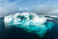
An iceberg floating on the ocean is a perfect illustration of isostasy (Figure 3.22). At Earth's ocean surface, solid freshwater glacier ice is about 10.7% less dense than cold seawater; as a result, ice floats. The amount of ice rising above the ocean surface is in equilibrium with the buoyant ice below the surface. As icebergs melt, the amount of ice above the surface adjusts to the buoyant volume below the surface. The ratio of the amount of ice above and below the surface remains the same as the ice melts.
Isostasy determines the elevation of the land surface on continents and the depth of ocean basins. The thickness and density of lithosphere determines how high mountains rise above surface on continents and on the ocean floor. In addition, thickness and density of lithosphere determines how deep ocean basins are.
Isostasy also causes vertical movement of the crust. For example, If a section of lithosphere is loaded, as by ice of a continental glacier, it will slowly subside to a new equilibrium position. When the continental glacier melts, the removal of the weight allows to slowly rebound back to isostatic equilibrium. Parts of northern North America and Europe that were covered by continental glaciers during the last ice age are now slowly rising eventually back to isostatic equilibrium (this action is called glacial rebound) (Figure 3.21).
The crust is always readjusting to changing forces from below and above. If a section of lithosphere is reduced in mass, as by erosion, it will slowly rise to a new equilibrium position. Increases in heat flow from the mantle cause crustal rocks to warm, expand, and rise. Old ocean crust becomes cold and shrinks, and with its mafic composition becomes denser and sinks back into the mantle.
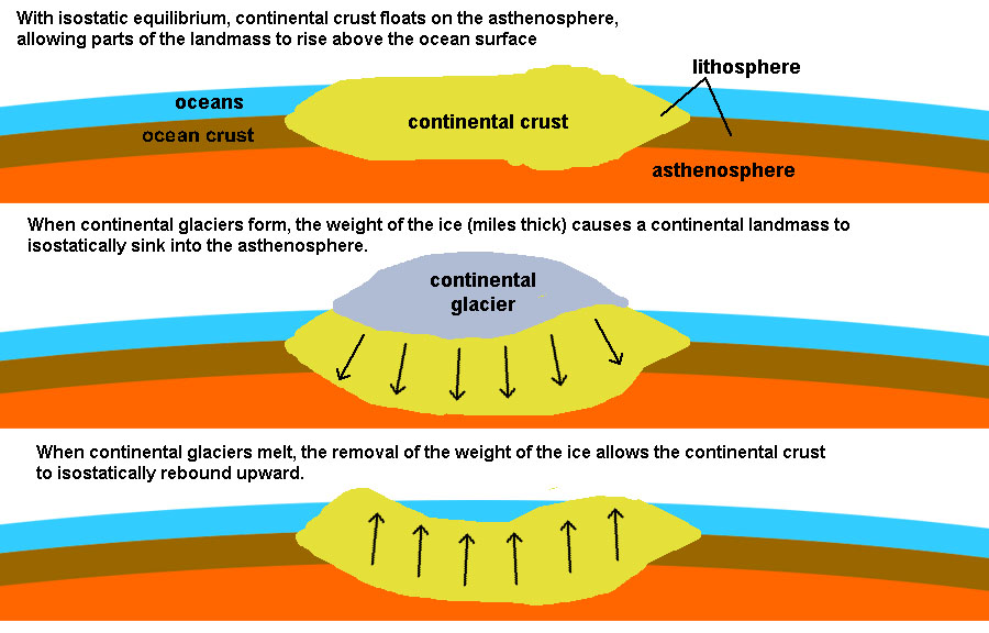
Fig-23. Isostatic rebound caused by the melting of continental glaciers reveals the fluid-like behavior of the asthenosphere.
Isostasy and the Age and Evolution of Continental Landmasses
Many hypotheses were put forward to try to explain the evolution of landscapes—isostasy was one of them. Early hypotheses focused on what was easily observable. Continents around the world shared a variety of large physiographic features: mountain ranges, coastal plains, plateau regions, and inland lowlands. Some of these lowland regions are underlain by what appeared to be ancient rocks that were once to core of mountain ranges in the distant past. These regions were located near the center of most of the continents and have became known as shields (such as the Canadian Shield of North America, see Figure 3.24). In most cases, these shields are surrounded by belts of mountain ranges that were composed of rocks that appeared younger than the shield regions. Also, some of these mountain ranges appeared much younger than other mountain ranges. This lead to conclusions that landscapes could be classified as youthful, mature, or old age —assuming that all mountain ranges form about the same way, and that youthful mountain ranges, like the Himalayan or Rocky Mountains eventual erode way (becoming more mature with age, like the Appalachian Mountains). Eventually almost all elevated features (mountains, hills) completely erode away, producing "old age" landscapes, similar to what is seen in shield regions (see Figure 3.24). The erosion of material from continental region contribute mass to the submerged regions along continental margins. In many regions along the continental margins the weight of additional sediments are casing them to sink (such as near the mouth of rivers, such as the Gulf Coast near the Mississippi River delta).
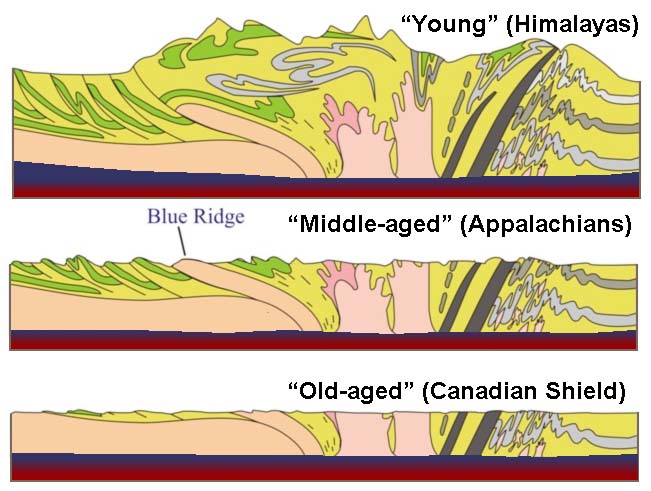
Figure 3.24. Isostasy and the hypothesis of landscapes evolving through youthful, mature, and old age stages. Evolution of a landscape over time involves uplift, erosion, and isostasy.
The assumption is that as materials erode away, the crust readjusts itself to maintain an isostatic equilibrium. As material is removed the crust rises. Over time, material that were once deep within mountain ranges eventually becomes exposed at the surface by erosion. Over time, the assumption was that isostatic adjustments eventually cease, and the mountains would completely erode away to a flat plain and eventually sink below the waves. Unfortunately, there were too many cases where the isostatic adjustment hypotheses didn't match all the observable facts. Not all old shield regions were low plains (as illustrated with the Scandinavian region of Europe and much of Africa). In addition, some regions, such as the Colorado Plateau, had characteristics that fit into all three categories, youthful, mature, and old age, all at the same time. In addition, there was very little to explain how mountain ranges and continents formed in the first place! Why do some mountain ranges have volcanoes and other don't? What would explain the composition and distribution of volcanic mountain ranges around the world, and what in the world could explain what chains of volcanoes like the Hawaiian archipelago were doing in the middle of the Pacific Ocean? These questions (and more) were finally resolved with the development of Plate Tectonic Theory.