15.4.2: E.4.2- Developments outside area
- Page ID
- 16469

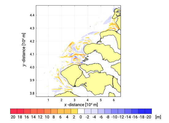
The influence of the Delta Works is reflected by the changes in delta topography. The most important factors influencing the morphological geometry at the ebb-tidal delta’s are: 1) the relative influence of waves versus tidal flow, 2) the average wave direction and 3) the interaction between tidal flow offshore and in the nearshore channels (Sha & Van den Berg, 1993). The sedimentation-erosion pattern is shown in Fig. E.8.
The Haringvliet and the Grevelingen have in common that they are closed for tidal flow by the Delta Works. The Haringvliet Sluices only allow discharge of fresh water from the former estuary during periods with high river discharges. The Brouwersdam even forms a complete closure for the estuary. In both ebb-tidal delta areas the influence of the tidal flow has significantly decreased after the closures, whereas the wave influence has not changed much. The morphological developments in the two areas also show similar patterns: erosion at the outer edge of the deltas (shore face), formation of sand bars that retreat landwards at the north side of the deltas, and sedimentation in the former tidal channels. The development can mainly be explained by the disappearance of the tidal flow in the cross-shore direction, and thus a significant decrease of the tidal volume. A smaller tidal volume means a smaller ebb-tidal delta and smaller tidal channels for the new equilibrium. This explains the erosion at the shore face and the sedimentation in the tidal channels.
That this has resulted in an opposite overall sediment balance is due to the difference in relative position of the closures. The Haringvliet Sluices are located relatively landwards, partly also due to the construction of the Maasvlakte (extension of the Rotterdam harbour area). This means that the area outside the Sluices with sediment deficiting channels is relatively large. So the sedimentation in the channels is dominating with respect to the shore face erosion, resulting into a positive overall sediment balance. The Brouwersdam is located relatively seawards, making the shore face erosion dominant with respect to the sedimentation in the channels, and resulting into a neg- ative overall sediment balance. The morphological development in these two areas is in fact tending to establish an ongoing smooth coastline, because of the disconnection with the estuaries.
The influence of the tidal volume on the morphological development can also be observed at the Eastern Scheldt delta. The delta front propagated seaward from 1969 to 1980 due to an 8 % increase in tidal volume by the closure of Volkerak in 1969. After the construction of the storm surge barrier in 1986 the tidal volume decreased causing erosion of the shore face (Aarninkhof & Van Kessel, 1999). The three remaining channels (Hammen, de Schaar van Roggenplaat and the Roompot) that form inlets in the barrier deepened, and the lee side of the dam accreted. The other channels decreased in size and found a new orientation due to the reduction and rotation (more in the along shore direction instead of cross-shore) of the tidal flow.


