
12.1: Front Matter
- Page ID
- 14567

The Water Cycle
How many times a day do you take water for granted? Do you assume the tap will be flowing when you turn on your faucet? That the shower will turn on, the toilet will flush, and you’ll have water to cook your meals? Not only is water necessary for many of life’s functions, it is also a considerable geologic agent. Water can sculpt the landscape dramatically over time, by both carving canyons and depositing thick layers of sediment. Some of these processes are slow and result in landscapes worn down over time; others, such as floods, can be dramatically fast and dangerous.
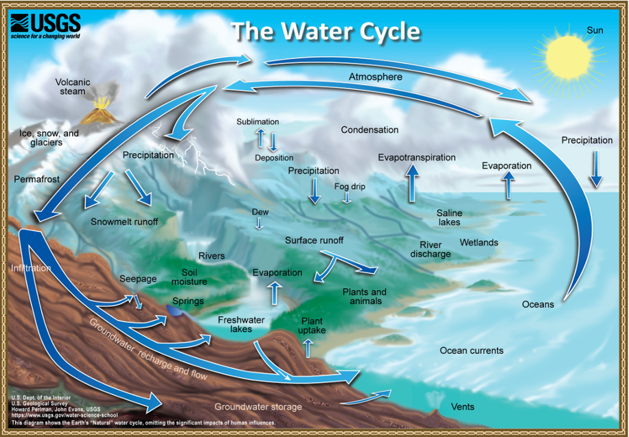
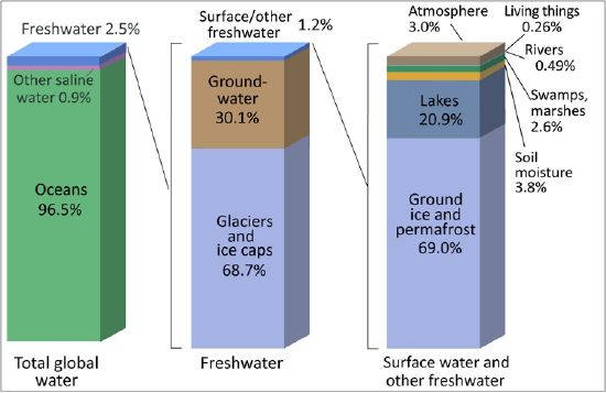
What happens to water during a rainstorm? Imagine that you are outside in a parking lot with grassy areas nearby. Where does the water from the parking lot go? Much of it will run off as sheet flow and eventually join a stream. What happens to the rain in the grassy area? Much of it will infiltrate, or soak into the ground. Water is continually recycled through the atmosphere, to the land, and back to the oceans. This movement of water through the Earth System is referred to as the hydrologic (water) cycle (Figure 12.1). At Earth’s surface, this cycle, powered by the sun, operates easily since water can change form from liquid to gas (or water vapor) quickly. The majority of water is called surface water and is stored in oceans, but there are freshwater resources in lakes, rivers, and trapped away in glaciers and ice sheets (discussed in a future chapter; Figure 12.2). Additional water resources are also found in the ground, and that’s what we’ll be discussing here.
Those who study water, water resources, or the landforms made by water, may have many titles, including hydrologist, hydro-geologist, geomorphologist, or geochemist, to name a few. Like many other geoscientists, working with other disciplines is common, with a heavy influence from both math and technology. Many are employed by universities where they teach and/or do research, and state and federal agencies, including geological surveys, like the California Geological Survey or United State Geological Survey (USGS). Additional career pathways are available in the private sector including in mining and natural resource extraction or in hazard mitigation and assessment. Many of these career options require a college degree and postgraduate work. If you are interested, talk to your geology instructor for advice. We recommend completing as many math and science courses as possible (chemistry is incredibly important for mineralogy). Also, visit National Parks, CA State Parks, museums, gem & mineral shows, or join a local rock and mineral club. Typically, natural history museums will have wonderful displays of rocks, including those from your local region. Here in California, there are a number of large collections, including the San Diego Natural History Museum, Natural History Museum of Los Angeles County, Santa Barbara Museum of Natural History, and Kimball Natural History Museum. Many colleges and universities also have their own collections/museums.
What Is Groundwater?
What do you picture when you hear the word “groundwater”? Flowing rivers underground? Hidden lakes in dark caves? The vast majority of groundwater is actually held in porous rock or sediment, and is slowly seeping from one small pore to another, much like how water is absorbed into a sponge (Figure 12.3).
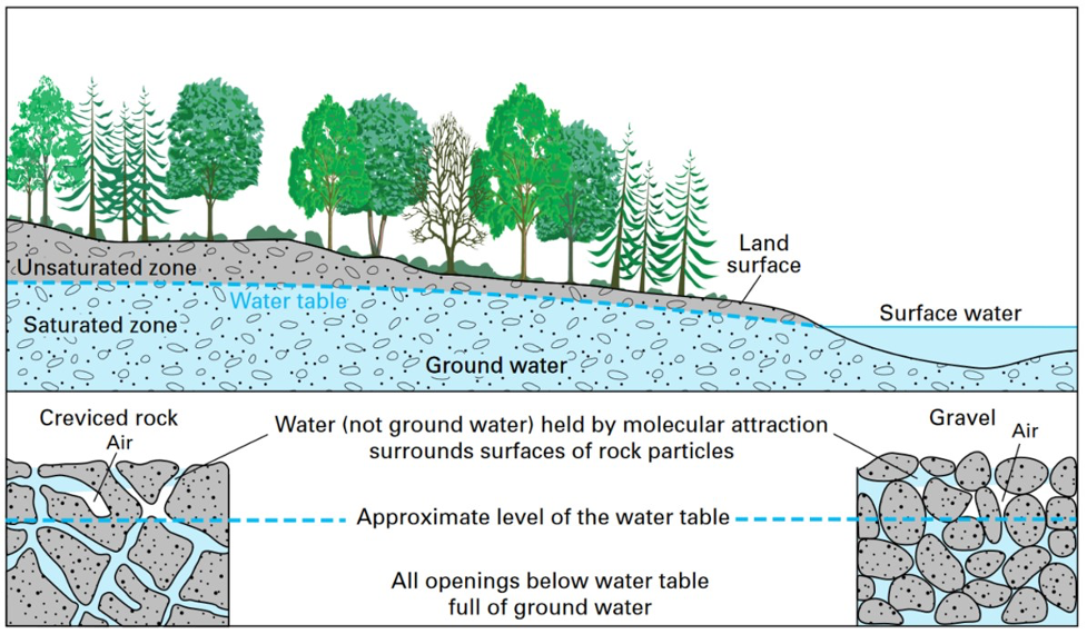
Have you ever been to the beach and dug a hole, only to have it fill with water from the base? If so, you had reached the water table: the boundary between the unsaturated and saturated zones. Rocks and soil at and just beneath the land’s surface are part of the unsaturated zone; pore spaces here are filled with air. Moving down from the surface, we will sooner or later reach the water table, where rocks and soil pore spaces are filled with water in the saturated zone. The saturated zone beneath the water table is called an aquifer, which are potentially huge storehouses of water.
The water table is said to mimic topography, in that it generally lies near the surface of the ground (often tens of feet below the surface, though this can vary greatly with location) and rises with hills and sinks with valleys, often discharging into streams. The water table receives additional inputs when rainfall infiltrates into the ground; this is called recharge. The position of the water table is dynamic: during droughts it will lower, and during wet times it will rise.
Two important properties of groundwater that influence its availability and movement are porosity and permeability. Porosity refers to the open or void space within the rock (Figure 12.4). It is expressed as a percentage of the volume of open space compared to the total rock volume. Porosity will vary with rock type. Many rocks with tight interlocking crystals (such as igneous and metamorphic rocks) will have low porosity since they lack open space. Sedimentary rocks composed of well-sorted sediment tend to have high porosity because of the abundant spaces between the grains that make them up. Envision a room filled from floor to ceiling with basketballs (similar to a rock composed completely of sand grains). Now add water to the room. The room will be able to hold a good deal of water, since the basketballs do not pack tightly due to their shape. That would be an example of high porosity.
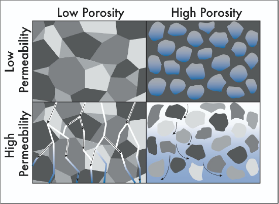
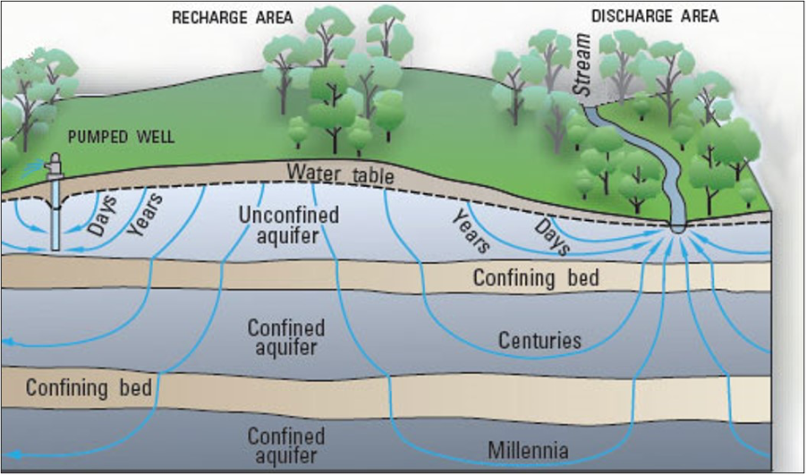
If the open spaces are connected, water will be able to flow through them; this is why rocks that are permeable make good aquifers (Figure 12.4). Sedimentary rocks, such as sandstone and limestone, are good aquifers. Rocks that are impermeable make confining layers (aquicludes or aquitards) and prevent the flow of water. Examples of confining layers would be sedimentary rocks like shale (composed of tiny clay and silt grains) or unfractured igneous or metamorphic rock. In a confined aquifer, the aquifer is topped by a confining layer (Figure 12.5). In an unconfined aquifer, the top of the aquifer is the water table.
Just like surface runoff, groundwater generally flows from areas of higher elevation to lower elevation in the shallow subsurface. Approximately 20% of the water used in the United States is groundwater, and this water has the potential to become contaminated, mostly from sewage, landfills, industry, and agriculture. The movement of groundwater helps spread the pollutants, making containment and mitigation a challenge.
Karst Topography
The sedimentary rock limestone is composed of the mineral calcite, which is water soluble; this means it will dissolve in water that is weakly acidic. In humid areas where limestone is present, water dissolves away the rock, forming large cavities and depressions that vary in size and shape. As more dissolution occurs, the caves become unstable and collapse, creating sinkholes (Figure 12.6).
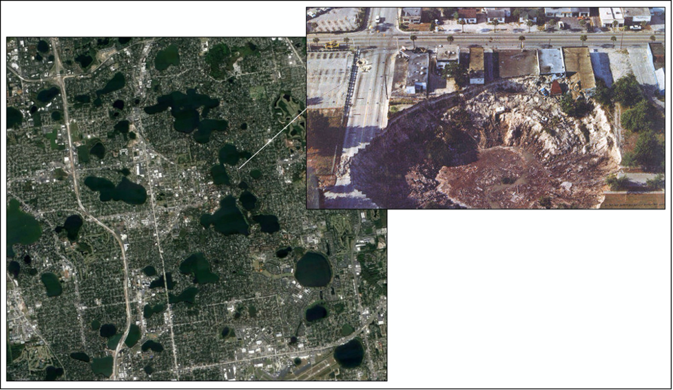
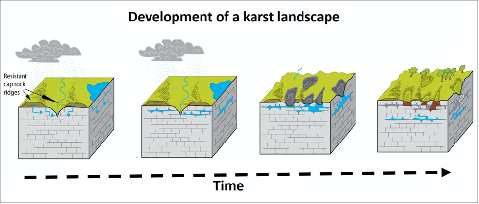
These broad, crater-like depressions are typical of karst topography, named after the Karst region in Slovenia. Karst topography is characterized by sinkholes, sink lakes (sinkholes filled with water), caves, and disappearing streams (surface streams that disappear into a sinkhole) (Figure 12.7).
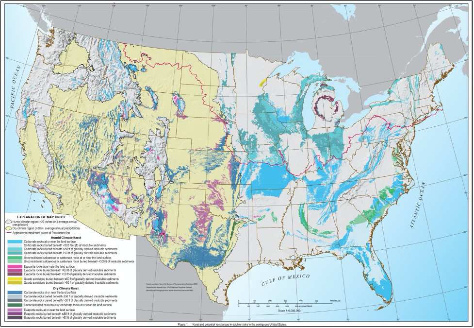
Living on a karst landscape poses unique challenges, and approximately one fourth of Americans in the lower 48 states live in these regions (Figure 12.8).
Attributions
- Figure 12.1: “The Water Cycle” (Public Domain; Howard Perlman and John Evans, USGS)
- Figure 12.2: “Where is Earth’s Water?” (Public Domain; USGS Water Science School
- Figure 12.3: “Groundwater is the Saturated Zone of Soil/Rock Below the Land Surface” (Public Domain; USGS)
- Figure 12.4: “Porosity and Permeability” (CC-BY 4.0; Emily Haddad, own work)
- Figure 12.5: “Conceptual Groundwater-Flow Diagram” (Public Domain; USGS)
- Figure 12.6: Derivative of “Winter Park Florida Sinkhole of 1981” (Public Domain; USGS) by Chloe Branciforte
- Figure 12.7: Derivative of “Development of Karst Landscapes” (Public Domain; Trista L. Thornberry-Ehrlich, Colorado State University via NPS) by Chloe Branciforte
- Figure 12.8: “Karst Areas of the Contiguous United States” (Public Domain; USGS)