
21.2: Coastal Landforms and Processes
- Page ID
- 17314

\( \newcommand{\vecs}[1]{\overset { \scriptstyle \rightharpoonup} {\mathbf{#1}} } \)
\( \newcommand{\vecd}[1]{\overset{-\!-\!\rightharpoonup}{\vphantom{a}\smash {#1}}} \)
\( \newcommand{\dsum}{\displaystyle\sum\limits} \)
\( \newcommand{\dint}{\displaystyle\int\limits} \)
\( \newcommand{\dlim}{\displaystyle\lim\limits} \)
\( \newcommand{\id}{\mathrm{id}}\) \( \newcommand{\Span}{\mathrm{span}}\)
( \newcommand{\kernel}{\mathrm{null}\,}\) \( \newcommand{\range}{\mathrm{range}\,}\)
\( \newcommand{\RealPart}{\mathrm{Re}}\) \( \newcommand{\ImaginaryPart}{\mathrm{Im}}\)
\( \newcommand{\Argument}{\mathrm{Arg}}\) \( \newcommand{\norm}[1]{\| #1 \|}\)
\( \newcommand{\inner}[2]{\langle #1, #2 \rangle}\)
\( \newcommand{\Span}{\mathrm{span}}\)
\( \newcommand{\id}{\mathrm{id}}\)
\( \newcommand{\Span}{\mathrm{span}}\)
\( \newcommand{\kernel}{\mathrm{null}\,}\)
\( \newcommand{\range}{\mathrm{range}\,}\)
\( \newcommand{\RealPart}{\mathrm{Re}}\)
\( \newcommand{\ImaginaryPart}{\mathrm{Im}}\)
\( \newcommand{\Argument}{\mathrm{Arg}}\)
\( \newcommand{\norm}[1]{\| #1 \|}\)
\( \newcommand{\inner}[2]{\langle #1, #2 \rangle}\)
\( \newcommand{\Span}{\mathrm{span}}\) \( \newcommand{\AA}{\unicode[.8,0]{x212B}}\)
\( \newcommand{\vectorA}[1]{\vec{#1}} % arrow\)
\( \newcommand{\vectorAt}[1]{\vec{\text{#1}}} % arrow\)
\( \newcommand{\vectorB}[1]{\overset { \scriptstyle \rightharpoonup} {\mathbf{#1}} } \)
\( \newcommand{\vectorC}[1]{\textbf{#1}} \)
\( \newcommand{\vectorD}[1]{\overrightarrow{#1}} \)
\( \newcommand{\vectorDt}[1]{\overrightarrow{\text{#1}}} \)
\( \newcommand{\vectE}[1]{\overset{-\!-\!\rightharpoonup}{\vphantom{a}\smash{\mathbf {#1}}}} \)
\( \newcommand{\vecs}[1]{\overset { \scriptstyle \rightharpoonup} {\mathbf{#1}} } \)
\(\newcommand{\longvect}{\overrightarrow}\)
\( \newcommand{\vecd}[1]{\overset{-\!-\!\rightharpoonup}{\vphantom{a}\smash {#1}}} \)
\(\newcommand{\avec}{\mathbf a}\) \(\newcommand{\bvec}{\mathbf b}\) \(\newcommand{\cvec}{\mathbf c}\) \(\newcommand{\dvec}{\mathbf d}\) \(\newcommand{\dtil}{\widetilde{\mathbf d}}\) \(\newcommand{\evec}{\mathbf e}\) \(\newcommand{\fvec}{\mathbf f}\) \(\newcommand{\nvec}{\mathbf n}\) \(\newcommand{\pvec}{\mathbf p}\) \(\newcommand{\qvec}{\mathbf q}\) \(\newcommand{\svec}{\mathbf s}\) \(\newcommand{\tvec}{\mathbf t}\) \(\newcommand{\uvec}{\mathbf u}\) \(\newcommand{\vvec}{\mathbf v}\) \(\newcommand{\wvec}{\mathbf w}\) \(\newcommand{\xvec}{\mathbf x}\) \(\newcommand{\yvec}{\mathbf y}\) \(\newcommand{\zvec}{\mathbf z}\) \(\newcommand{\rvec}{\mathbf r}\) \(\newcommand{\mvec}{\mathbf m}\) \(\newcommand{\zerovec}{\mathbf 0}\) \(\newcommand{\onevec}{\mathbf 1}\) \(\newcommand{\real}{\mathbb R}\) \(\newcommand{\twovec}[2]{\left[\begin{array}{r}#1 \\ #2 \end{array}\right]}\) \(\newcommand{\ctwovec}[2]{\left[\begin{array}{c}#1 \\ #2 \end{array}\right]}\) \(\newcommand{\threevec}[3]{\left[\begin{array}{r}#1 \\ #2 \\ #3 \end{array}\right]}\) \(\newcommand{\cthreevec}[3]{\left[\begin{array}{c}#1 \\ #2 \\ #3 \end{array}\right]}\) \(\newcommand{\fourvec}[4]{\left[\begin{array}{r}#1 \\ #2 \\ #3 \\ #4 \end{array}\right]}\) \(\newcommand{\cfourvec}[4]{\left[\begin{array}{c}#1 \\ #2 \\ #3 \\ #4 \end{array}\right]}\) \(\newcommand{\fivevec}[5]{\left[\begin{array}{r}#1 \\ #2 \\ #3 \\ #4 \\ #5 \\ \end{array}\right]}\) \(\newcommand{\cfivevec}[5]{\left[\begin{array}{c}#1 \\ #2 \\ #3 \\ #4 \\ #5 \\ \end{array}\right]}\) \(\newcommand{\mattwo}[4]{\left[\begin{array}{rr}#1 \amp #2 \\ #3 \amp #4 \\ \end{array}\right]}\) \(\newcommand{\laspan}[1]{\text{Span}\{#1\}}\) \(\newcommand{\bcal}{\cal B}\) \(\newcommand{\ccal}{\cal C}\) \(\newcommand{\scal}{\cal S}\) \(\newcommand{\wcal}{\cal W}\) \(\newcommand{\ecal}{\cal E}\) \(\newcommand{\coords}[2]{\left\{#1\right\}_{#2}}\) \(\newcommand{\gray}[1]{\color{gray}{#1}}\) \(\newcommand{\lgray}[1]{\color{lightgray}{#1}}\) \(\newcommand{\rank}{\operatorname{rank}}\) \(\newcommand{\row}{\text{Row}}\) \(\newcommand{\col}{\text{Col}}\) \(\renewcommand{\row}{\text{Row}}\) \(\newcommand{\nul}{\text{Nul}}\) \(\newcommand{\var}{\text{Var}}\) \(\newcommand{\corr}{\text{corr}}\) \(\newcommand{\len}[1]{\left|#1\right|}\) \(\newcommand{\bbar}{\overline{\bvec}}\) \(\newcommand{\bhat}{\widehat{\bvec}}\) \(\newcommand{\bperp}{\bvec^\perp}\) \(\newcommand{\xhat}{\widehat{\xvec}}\) \(\newcommand{\vhat}{\widehat{\vvec}}\) \(\newcommand{\uhat}{\widehat{\uvec}}\) \(\newcommand{\what}{\widehat{\wvec}}\) \(\newcommand{\Sighat}{\widehat{\Sigma}}\) \(\newcommand{\lt}{<}\) \(\newcommand{\gt}{>}\) \(\newcommand{\amp}{&}\) \(\definecolor{fillinmathshade}{gray}{0.9}\)A coast or the coastal zone is a dynamic region where land is sculpted and shaped by wave action and currents. Barring the effects of tectonic uplift and sea level change, erosion is the dominate geomorphic process acting on coasts. Coastal sediments are subject to multiple episodes of erosion, transportation and deposition, though a net seaward transport takes place on a global scale. The deep ocean floor becomes the resting place for terrestrial sediment eroded from the land.
The combined effect of waves, currents and tides result in a variety of gradational processes acting in the coastal zone. Most important is abrasion, caused by the scraping or impact of sediment carried by water thrown against shore materials. Breakers are particularly effective at lifting larger rocks and hurling them against the shore.
Hydraulic action caused by the direct impact of waves on the coast can be an effective geomorphic agent. Enormous pressures can build as water and air are compressed into rock fractures. Solution is locally important especially where soluble rock is exposed along the shore.
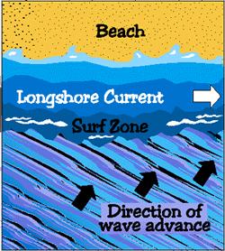
The water level in the surf zone increases as waves approach shore at an angle. The rising water moves parallel to the shore as a longshore current. Beach drifting transports sand grains along the beach as waves strike the shore at an oblique angle. Sediment is carried landward when water rushes across the beach as swash. Sediment is carried back toward the ocean as backwash. The continual up rush and backwash carries sand in a zig-zag like movement along the shore.
Depositional Coastal Landforms
Beaches
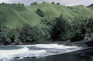
A beach is a deposit of loose sediment adjacent to a body of water. Though sand is common to most beaches, a remarkable diversity of sediment size, from boulders to fine silt is found on beaches around the world. Larger particles and steeper slopes are found where wave action is high. Fine particles and gentle slopes are characteristic of beaches exposed to low wave action.
Most midlatitude beaches undergo a cycle of erosion and deposition following the seasonal changes in wave action. During the winter, midlatitude storms are more vigorous producing more wave action and erosion. Hence, beaches tend to narrow during the winter. Wave action subsides during the summer as storms weaken somewhat favoring deposition over erosion and producing broader beaches.
Spits and bars
A sand spit is one of the most common coastal landforms. A sand spit is a linear accumulation of sediment that is attached to land at one end. Sand carried parallel to shore by longshore drift may eventually extend across a bay or between headlands especially where water is relatively calm. Spits are typically elongate, narrow features built to several dozen feet by wind and waves.
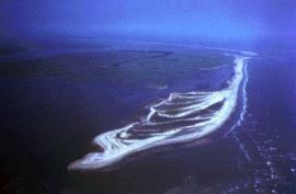
Spits often form when wave energy decreases as a result of wave refraction in a bay. When a coastline turns abruptly, wave energy is dissipated by divergence of wave trajectories, causing sediment to accumulate as the water loses its ability to transport.
Spits can extend across the mouth of a bay, but wave action is usually strong enough to wash sand out to sea or be deposited in the embayment. They may curve into the bay or stretch across connecting to the other side as a baymouth bar. When the bay is closed off by a bar it becomes a lagoon.
Wave energy also dissipates in the lee of large sea stacks or islets. Wave refraction sweeps sediment behind the obstruction from two directions, depositing it as a slender finger called a tombolo.
Barrier Islands
Coastlines paralleled by offshore narrow strips of sand dunes, salt marshes and beaches are known as barrier islands. Barrier island complexes stretch along the southeastern coast of North America from Long Island, New York to the Gulf coast of Texas. Many believe barrier islands originated as offshore bars built by waves breaking on a shallow shore. When waves begin to feel the tug of the ocean floor, they push sand toward shore as they break. The return undertow sweeps sand back to settle on the developing bar. These offshore bars were later exposed when the continent rebounded after ice age glaciers melted.

Larger barrier islands have been sought as "ideal" places to build vacation homes. Such scenic places are susceptible to the destructive forces of nature such as hurricanes, however. In 1989 Hurricane Hugo hit the U.S. mainland just north of Charleston, South Carolina, with sustained winds of 215 kilometers per hour and a storm surge of more than 6 meters. The barrier islands along the South Carolina coast are generally less than 3 meters above sea level. Most islands were inundated with water and in many places, beaches were severely eroded and dunes were leveled. Much of the sand eroded from the beach was over washed landward or carried offshore. South Carolina suffered $5.9 billion in damage and 29 people died.
Erosional Coastal Landforms
Some of the most spectacular scenery is found along coastlines and produced by the effects of wave erosion. Wave erosion undercuts steep shorelines creating coastal cliffs. A sea cliff is a vertical precipice created by waves crashing directly on a steeply inclined slope. Hydraulic action, abrasion, and chemical solution all work to cut a notch at the high water level near the base of the cliff. Constant undercutting and erosion causes the cliffs to retreat landward.
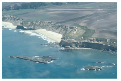
Sea caves form along lines of weakness in cohesive but well-jointed bedrock. Sea caves are prominent headlands where wave refraction attacks the shore.
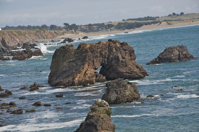
A sea arch forms when sea caves merge from opposite sides of a headland. If the arch collapses, a pillar of rock remains behind as a sea stack.
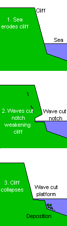
Seaward of the retreating cliffs, wave erosion forms a broad erosional platform called a wave-cut bench or wave-cut platform. After the constant grinding and battering, eroded material is transported to adjacent bays to become beaches or seaward coming to rest as a wave-built terrace. If tectonic forces raise the bench above the water level a marine terrace forms. Some shorelines have several marine terraces creating during various episodes of uplift.