20.2: Depositional Forms
- Page ID
- 17310

\( \newcommand{\vecs}[1]{\overset { \scriptstyle \rightharpoonup} {\mathbf{#1}} } \)
\( \newcommand{\vecd}[1]{\overset{-\!-\!\rightharpoonup}{\vphantom{a}\smash {#1}}} \)
\( \newcommand{\dsum}{\displaystyle\sum\limits} \)
\( \newcommand{\dint}{\displaystyle\int\limits} \)
\( \newcommand{\dlim}{\displaystyle\lim\limits} \)
\( \newcommand{\id}{\mathrm{id}}\) \( \newcommand{\Span}{\mathrm{span}}\)
( \newcommand{\kernel}{\mathrm{null}\,}\) \( \newcommand{\range}{\mathrm{range}\,}\)
\( \newcommand{\RealPart}{\mathrm{Re}}\) \( \newcommand{\ImaginaryPart}{\mathrm{Im}}\)
\( \newcommand{\Argument}{\mathrm{Arg}}\) \( \newcommand{\norm}[1]{\| #1 \|}\)
\( \newcommand{\inner}[2]{\langle #1, #2 \rangle}\)
\( \newcommand{\Span}{\mathrm{span}}\)
\( \newcommand{\id}{\mathrm{id}}\)
\( \newcommand{\Span}{\mathrm{span}}\)
\( \newcommand{\kernel}{\mathrm{null}\,}\)
\( \newcommand{\range}{\mathrm{range}\,}\)
\( \newcommand{\RealPart}{\mathrm{Re}}\)
\( \newcommand{\ImaginaryPart}{\mathrm{Im}}\)
\( \newcommand{\Argument}{\mathrm{Arg}}\)
\( \newcommand{\norm}[1]{\| #1 \|}\)
\( \newcommand{\inner}[2]{\langle #1, #2 \rangle}\)
\( \newcommand{\Span}{\mathrm{span}}\) \( \newcommand{\AA}{\unicode[.8,0]{x212B}}\)
\( \newcommand{\vectorA}[1]{\vec{#1}} % arrow\)
\( \newcommand{\vectorAt}[1]{\vec{\text{#1}}} % arrow\)
\( \newcommand{\vectorB}[1]{\overset { \scriptstyle \rightharpoonup} {\mathbf{#1}} } \)
\( \newcommand{\vectorC}[1]{\textbf{#1}} \)
\( \newcommand{\vectorD}[1]{\overrightarrow{#1}} \)
\( \newcommand{\vectorDt}[1]{\overrightarrow{\text{#1}}} \)
\( \newcommand{\vectE}[1]{\overset{-\!-\!\rightharpoonup}{\vphantom{a}\smash{\mathbf {#1}}}} \)
\( \newcommand{\vecs}[1]{\overset { \scriptstyle \rightharpoonup} {\mathbf{#1}} } \)
\(\newcommand{\longvect}{\overrightarrow}\)
\( \newcommand{\vecd}[1]{\overset{-\!-\!\rightharpoonup}{\vphantom{a}\smash {#1}}} \)
\(\newcommand{\avec}{\mathbf a}\) \(\newcommand{\bvec}{\mathbf b}\) \(\newcommand{\cvec}{\mathbf c}\) \(\newcommand{\dvec}{\mathbf d}\) \(\newcommand{\dtil}{\widetilde{\mathbf d}}\) \(\newcommand{\evec}{\mathbf e}\) \(\newcommand{\fvec}{\mathbf f}\) \(\newcommand{\nvec}{\mathbf n}\) \(\newcommand{\pvec}{\mathbf p}\) \(\newcommand{\qvec}{\mathbf q}\) \(\newcommand{\svec}{\mathbf s}\) \(\newcommand{\tvec}{\mathbf t}\) \(\newcommand{\uvec}{\mathbf u}\) \(\newcommand{\vvec}{\mathbf v}\) \(\newcommand{\wvec}{\mathbf w}\) \(\newcommand{\xvec}{\mathbf x}\) \(\newcommand{\yvec}{\mathbf y}\) \(\newcommand{\zvec}{\mathbf z}\) \(\newcommand{\rvec}{\mathbf r}\) \(\newcommand{\mvec}{\mathbf m}\) \(\newcommand{\zerovec}{\mathbf 0}\) \(\newcommand{\onevec}{\mathbf 1}\) \(\newcommand{\real}{\mathbb R}\) \(\newcommand{\twovec}[2]{\left[\begin{array}{r}#1 \\ #2 \end{array}\right]}\) \(\newcommand{\ctwovec}[2]{\left[\begin{array}{c}#1 \\ #2 \end{array}\right]}\) \(\newcommand{\threevec}[3]{\left[\begin{array}{r}#1 \\ #2 \\ #3 \end{array}\right]}\) \(\newcommand{\cthreevec}[3]{\left[\begin{array}{c}#1 \\ #2 \\ #3 \end{array}\right]}\) \(\newcommand{\fourvec}[4]{\left[\begin{array}{r}#1 \\ #2 \\ #3 \\ #4 \end{array}\right]}\) \(\newcommand{\cfourvec}[4]{\left[\begin{array}{c}#1 \\ #2 \\ #3 \\ #4 \end{array}\right]}\) \(\newcommand{\fivevec}[5]{\left[\begin{array}{r}#1 \\ #2 \\ #3 \\ #4 \\ #5 \\ \end{array}\right]}\) \(\newcommand{\cfivevec}[5]{\left[\begin{array}{c}#1 \\ #2 \\ #3 \\ #4 \\ #5 \\ \end{array}\right]}\) \(\newcommand{\mattwo}[4]{\left[\begin{array}{rr}#1 \amp #2 \\ #3 \amp #4 \\ \end{array}\right]}\) \(\newcommand{\laspan}[1]{\text{Span}\{#1\}}\) \(\newcommand{\bcal}{\cal B}\) \(\newcommand{\ccal}{\cal C}\) \(\newcommand{\scal}{\cal S}\) \(\newcommand{\wcal}{\cal W}\) \(\newcommand{\ecal}{\cal E}\) \(\newcommand{\coords}[2]{\left\{#1\right\}_{#2}}\) \(\newcommand{\gray}[1]{\color{gray}{#1}}\) \(\newcommand{\lgray}[1]{\color{lightgray}{#1}}\) \(\newcommand{\rank}{\operatorname{rank}}\) \(\newcommand{\row}{\text{Row}}\) \(\newcommand{\col}{\text{Col}}\) \(\renewcommand{\row}{\text{Row}}\) \(\newcommand{\nul}{\text{Nul}}\) \(\newcommand{\var}{\text{Var}}\) \(\newcommand{\corr}{\text{corr}}\) \(\newcommand{\len}[1]{\left|#1\right|}\) \(\newcommand{\bbar}{\overline{\bvec}}\) \(\newcommand{\bhat}{\widehat{\bvec}}\) \(\newcommand{\bperp}{\bvec^\perp}\) \(\newcommand{\xhat}{\widehat{\xvec}}\) \(\newcommand{\vhat}{\widehat{\vvec}}\) \(\newcommand{\uhat}{\widehat{\uvec}}\) \(\newcommand{\what}{\widehat{\wvec}}\) \(\newcommand{\Sighat}{\widehat{\Sigma}}\) \(\newcommand{\lt}{<}\) \(\newcommand{\gt}{>}\) \(\newcommand{\amp}{&}\) \(\definecolor{fillinmathshade}{gray}{0.9}\)Dunes
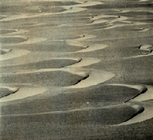
A sand dune is an accumulation of loose sand grains piled up by the wind. Dunes are most likely to form where winds are strong and generally blow from the same direction. Some of the most extensive dune fields are found in the world's great deserts like the Sahara. The dune fields of these great sandy deserts are called sand seas. Patches of dunes are found in the southwest desert of the United States. Ancient dune fields are found in regions that were dry in the past but now exhibit a more humid climate. Dune systems are found landward of beaches where sand is blown landward. Beach dunes are common along the coasts of the world's oceans and large lakes like the Great Lakes of North America.
Dune formation
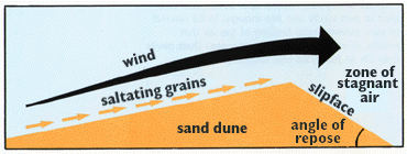
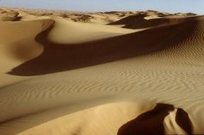
Dunes are primarily made up of accumulated sand grains. Finer silt and clay are carried further by the wind leaving the heavier sand grains behind. Generally, a dune forms an asymmetric cross-sectional form with a gentle windward or "stoss" slope and an steep leeward slope called the slip face. Saltating grains move up the windward slope and then come to rest at their angle of repose on the downwind side in a zone of stagnant air.
Dune types
A barchan or crescent dune forms as individual units commonly found in dry regions lacking vegetation. The elongated tips, or horns, point in the downwind direction. Barchans are found moving across a non-sandy surface of gravel or clay up of several tens of meters a year. Symmetrical barchan dunes indicate winds blowing from a constant direction.
Transverse dunes form perpendicular to the prevailing wind as accumulations of loose, well-sorted, very fine to medium sand. They have a gentle stoss slope (usually less than 15°) and a steep (32°) slip face.
Individual dunes whose horns point in the upwind direction are parabolic dunes. These hairpin-like dunes form where sand accumulates in a moist environment with a cover of vegetation. Vegetation or dampness in the lower part slows the dune motion there, permitting the dry crest to push ahead of its base causing the horns to be anchored behind.
Blowout dunes form from sand deposited at the end of an open-ended deflation hollow. Blowout dunes are common to many sandy coasts (coastal blowout dunes). The deflation hollow focuses the wind toward the center of the depression causing the sand to migrate landward as a dune. With little wind energy on the side of the hollow, the tails of the dune move much slower. As a result, beach plants like dune grass, sea oats or sand cherry can find a suitable habitat to flourish in. Once established, the plants help anchor the flanks to promote the formation of the characteristic parabolic shape.
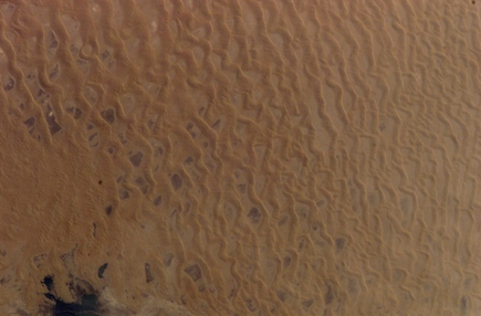
Longitudinal dunes form where wind blows from more than one direction in a region with an abundant supply of sand. In some places longitudinal dunes form long smooth "whalebacks', while in other regions they display knife-edged crests. Unlike transverse dunes, these do not migrate, but lengthen in size over time. Seifs are elongate dunes that resemble great windrows of sand. They form parallel to the direction of the wind, though are a product of shifting wind direction. The changing wind direction sends sand back and forth across the dune crest leaving a sharp knife-like profile.
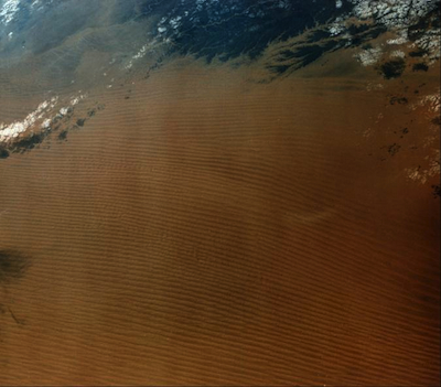
Ergs
Individual sand seas are referred to as ergs. Small ergs are present in most desert regions. North Africa and the Arabian desert contain the most spectacular forms on Earth with waves of sand covering tens of thousands of square kilometers. Ergs are also found in India, western China, and Australia. Star dunes are pyramidal-shaped mounds of sand with slipfaces on three or more arms radiating from the center and common to ergs. They tend to accumulate in areas where the wind comes from several different directions. Star dunes grow vertically rather than laterally.The Sand Hills of Nebraska are remnants of an ancient sand sea.
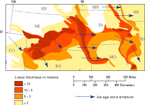
Loess
Loess is principally wind deposited silt, much of which was eroded from Pleistocene glacial sediments. Vast accumulations are spread across the upper Midwest United States, with significant deposits along major rivers like the Mississippi. As glaciers advanced across North America they ground the underlying rock into a powder-like "glacial flour". This sediment is laid down by glacial melt water and later eroded from the dry deposit by strong wind. The Loess Hills of Iowa and Loess Plateau of China are two well-known examples of loess topography.