7.10: Glacial Erosion
- Page ID
- 14342
\( \newcommand{\vecs}[1]{\overset { \scriptstyle \rightharpoonup} {\mathbf{#1}} } \)
\( \newcommand{\vecd}[1]{\overset{-\!-\!\rightharpoonup}{\vphantom{a}\smash {#1}}} \)
\( \newcommand{\id}{\mathrm{id}}\) \( \newcommand{\Span}{\mathrm{span}}\)
( \newcommand{\kernel}{\mathrm{null}\,}\) \( \newcommand{\range}{\mathrm{range}\,}\)
\( \newcommand{\RealPart}{\mathrm{Re}}\) \( \newcommand{\ImaginaryPart}{\mathrm{Im}}\)
\( \newcommand{\Argument}{\mathrm{Arg}}\) \( \newcommand{\norm}[1]{\| #1 \|}\)
\( \newcommand{\inner}[2]{\langle #1, #2 \rangle}\)
\( \newcommand{\Span}{\mathrm{span}}\)
\( \newcommand{\id}{\mathrm{id}}\)
\( \newcommand{\Span}{\mathrm{span}}\)
\( \newcommand{\kernel}{\mathrm{null}\,}\)
\( \newcommand{\range}{\mathrm{range}\,}\)
\( \newcommand{\RealPart}{\mathrm{Re}}\)
\( \newcommand{\ImaginaryPart}{\mathrm{Im}}\)
\( \newcommand{\Argument}{\mathrm{Arg}}\)
\( \newcommand{\norm}[1]{\| #1 \|}\)
\( \newcommand{\inner}[2]{\langle #1, #2 \rangle}\)
\( \newcommand{\Span}{\mathrm{span}}\) \( \newcommand{\AA}{\unicode[.8,0]{x212B}}\)
\( \newcommand{\vectorA}[1]{\vec{#1}} % arrow\)
\( \newcommand{\vectorAt}[1]{\vec{\text{#1}}} % arrow\)
\( \newcommand{\vectorB}[1]{\overset { \scriptstyle \rightharpoonup} {\mathbf{#1}} } \)
\( \newcommand{\vectorC}[1]{\textbf{#1}} \)
\( \newcommand{\vectorD}[1]{\overrightarrow{#1}} \)
\( \newcommand{\vectorDt}[1]{\overrightarrow{\text{#1}}} \)
\( \newcommand{\vectE}[1]{\overset{-\!-\!\rightharpoonup}{\vphantom{a}\smash{\mathbf {#1}}}} \)
\( \newcommand{\vecs}[1]{\overset { \scriptstyle \rightharpoonup} {\mathbf{#1}} } \)
\( \newcommand{\vecd}[1]{\overset{-\!-\!\rightharpoonup}{\vphantom{a}\smash {#1}}} \)
\(\newcommand{\avec}{\mathbf a}\) \(\newcommand{\bvec}{\mathbf b}\) \(\newcommand{\cvec}{\mathbf c}\) \(\newcommand{\dvec}{\mathbf d}\) \(\newcommand{\dtil}{\widetilde{\mathbf d}}\) \(\newcommand{\evec}{\mathbf e}\) \(\newcommand{\fvec}{\mathbf f}\) \(\newcommand{\nvec}{\mathbf n}\) \(\newcommand{\pvec}{\mathbf p}\) \(\newcommand{\qvec}{\mathbf q}\) \(\newcommand{\svec}{\mathbf s}\) \(\newcommand{\tvec}{\mathbf t}\) \(\newcommand{\uvec}{\mathbf u}\) \(\newcommand{\vvec}{\mathbf v}\) \(\newcommand{\wvec}{\mathbf w}\) \(\newcommand{\xvec}{\mathbf x}\) \(\newcommand{\yvec}{\mathbf y}\) \(\newcommand{\zvec}{\mathbf z}\) \(\newcommand{\rvec}{\mathbf r}\) \(\newcommand{\mvec}{\mathbf m}\) \(\newcommand{\zerovec}{\mathbf 0}\) \(\newcommand{\onevec}{\mathbf 1}\) \(\newcommand{\real}{\mathbb R}\) \(\newcommand{\twovec}[2]{\left[\begin{array}{r}#1 \\ #2 \end{array}\right]}\) \(\newcommand{\ctwovec}[2]{\left[\begin{array}{c}#1 \\ #2 \end{array}\right]}\) \(\newcommand{\threevec}[3]{\left[\begin{array}{r}#1 \\ #2 \\ #3 \end{array}\right]}\) \(\newcommand{\cthreevec}[3]{\left[\begin{array}{c}#1 \\ #2 \\ #3 \end{array}\right]}\) \(\newcommand{\fourvec}[4]{\left[\begin{array}{r}#1 \\ #2 \\ #3 \\ #4 \end{array}\right]}\) \(\newcommand{\cfourvec}[4]{\left[\begin{array}{c}#1 \\ #2 \\ #3 \\ #4 \end{array}\right]}\) \(\newcommand{\fivevec}[5]{\left[\begin{array}{r}#1 \\ #2 \\ #3 \\ #4 \\ #5 \\ \end{array}\right]}\) \(\newcommand{\cfivevec}[5]{\left[\begin{array}{c}#1 \\ #2 \\ #3 \\ #4 \\ #5 \\ \end{array}\right]}\) \(\newcommand{\mattwo}[4]{\left[\begin{array}{rr}#1 \amp #2 \\ #3 \amp #4 \\ \end{array}\right]}\) \(\newcommand{\laspan}[1]{\text{Span}\{#1\}}\) \(\newcommand{\bcal}{\cal B}\) \(\newcommand{\ccal}{\cal C}\) \(\newcommand{\scal}{\cal S}\) \(\newcommand{\wcal}{\cal W}\) \(\newcommand{\ecal}{\cal E}\) \(\newcommand{\coords}[2]{\left\{#1\right\}_{#2}}\) \(\newcommand{\gray}[1]{\color{gray}{#1}}\) \(\newcommand{\lgray}[1]{\color{lightgray}{#1}}\) \(\newcommand{\rank}{\operatorname{rank}}\) \(\newcommand{\row}{\text{Row}}\) \(\newcommand{\col}{\text{Col}}\) \(\renewcommand{\row}{\text{Row}}\) \(\newcommand{\nul}{\text{Nul}}\) \(\newcommand{\var}{\text{Var}}\) \(\newcommand{\corr}{\text{corr}}\) \(\newcommand{\len}[1]{\left|#1\right|}\) \(\newcommand{\bbar}{\overline{\bvec}}\) \(\newcommand{\bhat}{\widehat{\bvec}}\) \(\newcommand{\bperp}{\bvec^\perp}\) \(\newcommand{\xhat}{\widehat{\xvec}}\) \(\newcommand{\vhat}{\widehat{\vvec}}\) \(\newcommand{\uhat}{\widehat{\uvec}}\) \(\newcommand{\what}{\widehat{\wvec}}\) \(\newcommand{\Sighat}{\widehat{\Sigma}}\) \(\newcommand{\lt}{<}\) \(\newcommand{\gt}{>}\) \(\newcommand{\amp}{&}\) \(\definecolor{fillinmathshade}{gray}{0.9}\)Introduction
Glaciers are very effective in eroding, transporting, and depositing bedrock. How do we know that? There are three major lines of evidence:
- We can see material in transport by modern glaciers. In the most general way, where could such material have come from? Preexisting loose material (regolith; core stones; joint-bounded blocks); solid bedrock eroded by the glacier; and material that fell onto the glacier from bedrock weathering above. And we see glaciers making deposits.
- We observe deposits that by excellent evidence were deposited by glaciers.
- We observe landforms that are the result of glacial erosion.
The subject of glacial erosion is a difficult one. We know it happens, but it’s hard to observe how it happens. Very few tunnels have been driven to the base of a glacier to watch erosion, and those haven’t been representative anyway, in terms of depths and times involved. Also, very few experiments have been made. So there’s a lot of deduction and speculation, and this can be very dangerous. And this is not a very graphic or photogenic topic.
It’s generally agreed that there are two kinds of erosional activity of glaciers: abrasion and plucking (also called quarrying). These affect bedrock on different scales (although there are intergradations). For each, I’ll discuss evidence and possible mechanisms.
Glacial Abrasion
Tools (rock and mineral particles, large and small, held in the base of the moving ice) can abrade the underlying rock surface. Basically, this involves wearing away particle by particle.
What’s the evidence that this happens? Mainly glacial striations and rock flour.
Glacial striations, or glacial striae, are subparallel striations or grooves cut on the bedrock base of the glacier by tools frozen into the basal ice. They are a very common (although by no means ubiquitous) feature of glaciated areas. They are commonly are found on rounded undulating surfaces of glacially abraded bedrock. There’s a wide and continuous range in size, from microscopic, at the small end, to meters deep, meters wide, and hundreds of meters long. (The biggest grooves were probably made not by single tools but by groups of tools.) Striations are also on the larger tools themselves. Often the bedrock surface shows two or more intersecting directions, indicating either that the direction of ice flow changed or that the tools were rotated relative to direction of movement. The finest and most delicate striations are cut on soft fine-grained but nonfractured rocks like carbonates. They are coarser in medium-grained to coarse-grained rocks like granite or sandstone. Striations are fairly readily weathered, so they are best seen soon after they’re made or after they’re freshly uncovered of overlying sediment. Striations are known from ancient glaciations as well as Pleistocene glaciations.
If abrasion happens, there must be a fine-grained product. What’s the nature of this product, and what happens to it? Most of what’s produced by abrasion is mineral fragments, evidently mostly less than 100 micrometers, and predominantly fresh. This material, expressively called rock flour, is largely carried out of the glacier by meltwater; glacial streams have very high suspended- sediment concentrations of grams to tens of grams per liter, and even up to a few hundreds of grams per liter, which turn the streams a characteristic dilute-milk whitish color.
A case can be made for the necessity of continuous removal of the fine-grained abrasion products in order for abrasion to continue; otherwise the ice– rock interface would become clogged by this stuff, like overused sandpaper.
There are two ways for this to happen: it can be carried obliquely upward by flow of ice, under special circumstances of compressive flow, or more importantly, it can be washed out by meltwater. Remember that in a warm-based glacier, even if no meltwater is supplied from above, there will be a thin layer of flowing water, due to geothermal heat and friction, along the base from melting.
Direct observations on production of rock flour have been few and simple. One thing you might try to do is make marks or holes on the bedrock near the terminus and hope for readvance and then re-retreat within your lifetime. This points up the obvious difficulty in making systematic observations. Another more subtle difficulty is the possibility of weathering of the bedrock before readvance. The observation most often cited is some recent work that involved tunneling under a glacier and planting two rock slabs, one of marble and the other of basalt, at the base of an active glacier, retrieved after 9.5 m of passage of tool-studded ice over them. Both slabs became striated; the marble lost 3 mm of thickness, and the basalt lost 1 mm.
How about the mechanism or mechanisms of abrasion? Probably many of you have seen striations, but how are they made? By the ice dragging tools across the bedrock, you would say; yes, but under what conditions does this happen?
The first and most important condition for abrasion is that the glacier ice has to be moving at the base. That seems to mean that abrasion is important only under warm-based ice, for which there is basal slip. Cold-based ice is “glued” (frozen fast) to bedrock, and so doesn’t drag tools across the bedrock. Only if there are very large tools that stick up into faster-moving ice and are rotated and pushed down against bedrock can there be abrasion in this case. Abrasion is generally conceded to be minimal in cold-based glaciers, especially when they’re relatively clean.
But even in warm-based glaciers there’s a considerable problem in keeping the tools in contact with the bedrock. Consider an isolated tool at the base of the glacier. As it rides along bedrock and exerts a normal force on the bedrock, the bedrock exerts an equal and opposite normal force on the tool (Figure 5-34). If there’s basal slip in the first place, then the ice at the base is at its pressure melting point, and this means that the tool will retract slowly into the ice, and therefore stops abrading the bedrock!
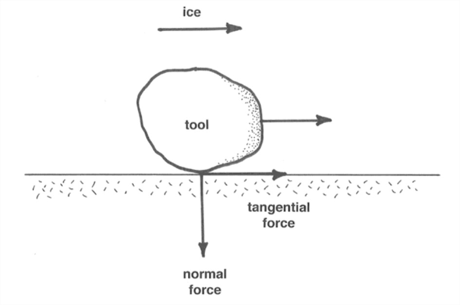
But there are invariably many tools, presumably of all sizes, packed in near the base of the glacier. Higher tools tend to hold lower tools to the base. Remember that the ice is also exerting tractive forces on the tools to keep them moving forward against the tangential resistance of the bedrock sole. Imagine a large tool, being pushed forward by the ice, and in turn pushing a smaller tool downward onto the bedrock (Figure 5-35): this produces a very large abrasive force on a small area for a long time, because the large tool retracts only very slowly, given its large area and relatively small ice–rock contact force.
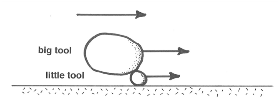
But why wouldn’t a condition eventually be reached in which all tools have attained a state of retraction? It seems as though this has to happen, eventually. So for continuing abrasion a mechanism is needed for replenishment of tools at the base of the glacier.
Something else to remember is that the tools themselves are abraded approximately as fast as the bedrock, if the two are of about the same resistance to abrasion. (If the tool is softer than the bedrock, the bedrock tends to abrade the tools, whereas if the bedrock is softer than the took, then the tool tends to abrade the bedrock.)
So tools are progressively used up, and new ones have to be supplied from somewhere. Probably the most efficacious abrasion happens in a situation where fragments are incorporated into the ice base by quarrying somewhere and then carried downglacier to abrade softer rocks.
The whole field of abrasion micromechanics is (as you can see) in a very speculative state. It’s ripe for further observation, experiment, and theoretical work. (But there are difficulties with all three).
Striations tell you the orientation of the ice movement at the time they were cut. Unfortunately they don’t give you the direction as well as the orientation of the movement: some are asymmetrical one way, others asymmetrical the other way. An obvious thing to do is map the orientations of striations over large areas to get an idea of the patterns of glacier movement. This has been done many times (Figure 5-36 is a good example), and the results are valuable.
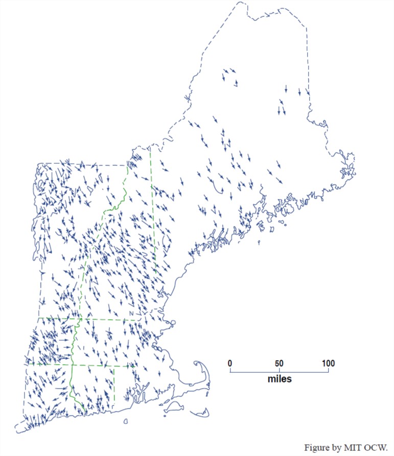
But there are some serious problems and limitations:
- Commonly there are very strong local variations in orientation because of local topography. So you either have to make very detailed maps or do some averaging. Striations indicate that flow can be locally at 90° to the main flow in small troughs oriented across the ice movement, or even “eddies” in cavities.
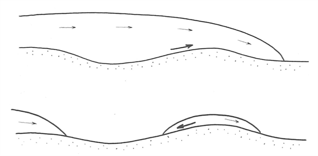
- Directions of ice movement can change with time as the geometry of ice sheets and ice caps changes as they wax and wane. In particular, there can be almost complete reversal if an outlying ice cap develops on a locally higher area during general retreat of an ice sheet (Figure 7-37). This seems to have happened in North America just south of the St. Lawrence depression.
A related point to remember is that striations record only the very latest abrasion, and this could be radically different in orientation from earlier, and perhaps more important, abrasion. It’s probably typical that the last ice movement is unrepresentative of the main ice movement.
Finally, another important point is that striations on bedrock surfaces have been observed to be produced by several other mechanisms:
- drifting ice (icebergs or ice floes)
- debris flows
- snowslides and avalanches
And unfortunately you can’t tell which mechanism just by looking at striations. Other evidence is usually available, though.
Another minor abrasional feature often discussed in the literature is friction cracks. These are of several characteristic kinds, all apparently produced by the normal and tangential forces exerted cyclically by tools on bedrock at regularly spaced points in the downstream direction. These cracks occur in trains analogous to the chatter marks produced in certain machining operations, and they are probably a manifestation of stick-slip friction.
Some of these friction cracks show removal of material from the bedrock surface; if they are concave upglacier they are called crescentic gouges, and if they are convex upglacier they are called lunate fractures. Others, called crescentic fractures, show no removal of material from the bedrock surface; these are almost always (or even always?) convex upglacier.
Controls on the geometry and spacing of friction cracks are unclear. Some experiments on scoring of optical glass with steel balls have been made to simulate, crudely, the conditions under which friction cracks are made. From these experiments it’s known in a general way that crescentic fractures are produced when there’s no rolling, and crescentic gouges are produced when there’s rolling. In any case, it’s clear that friction cracks are not reliable indicators of the direction of ice movement.
Glacial Quarrying
Glacial quarrying, glacial plucking, and joint-block removal are approximately equivalent terms for a process involving incorporation of relatively large discrete fracture-bounded blocks into the moving ice at the base of the glacier. Typically this process is viewed as operating on fragments that are decimeters to several meters across.
Glacial quarrying must be a very important mode of glacial erosion, because how else can you get all the large fragments observed to be carried in glaciers and in glacial deposits (assuming that there is a definite limit to the material initially available before the glacier covered the area)?
The evidence for glacial quarrying is perhaps best summarized by discussing what is usually considered to be the most characteristic form of glacial erosion: stoss-and-lee topography.
Just as common as simply abraded surfaces is a landform that involves hillocks or knobs of bedrock on scales of meters to tens of meters to even a few hundreds of meters in plan view. These hills have a strong tendency to be asymmetrical, with gentle and streamline-molded upstream sides and steep downstream sides. The upstream sides are smoothly rounded in the large and striated in the small. The downstream sides are rough, blocky, and craggy.
The usual interpretation of stoss-and-lee topography is that it developed by erosion by moving ice, involving (minor) abrasion on upstream side and (major) quarrying on downstream side. Jointing patterns in the bedrock are thus important in controlling the shape of the stoss-and-lee topography.
Stoss-and-lee topography is less good in giving the orientation of ice movement (to maybe 10–20°) but is definitive evidence of direction and is less likely to be produced only by the last phase of glaciation.
There is disagreement in the literature over whether stoss-and-lee topography is a transient or steady-state aspect of glacial erosion.
The mechanism for glacial plucking in general is very poorly understood. An obvious requirement is the existence of fractures and joints in the bedrock. (Bedrock with tight and widely spaced joints is just not likely to be quarried.)
Joints and fractures can obviously predate the glacier, either because the rock was jointed long before or was fractured just before. One popular European school of thought holds that most glacial quarrying is the result of fracturing that takes place just before the arrival of the glacier; active frost wedging in a periglacial (that is, near the glacier) climate in advance of the expanding glacier prepares the way.
Another interesting possibility is that the production of joints is occasioned by the presence of the glacier itself. Dilatation joints are produced along surfaces congruent to the bedrock surface by unloading of overlying rock, by erosion, or by artificial means in quarries. In quarries, sometimes a rock face bursts outward, producing such a dilatation joint, because the rock has tendency to expand upon unloading. Some workers think that such dilatation joints can be produced beneath a glacier: as a glacier erodes rock and fills a deeper and deeper depression, hydrostatic pressure at the glacier base, although greater than if the glacier were not there, is much less than it was before the rock was eroded, because the density of ice is much less than that of rock.
What could be interpreted as good evidence of this is the existence of prominent dilatational jointing congruent to the walls of major deep glaciated valleys. (Remember that the valleys must have been produced by the glacier, and not just there from before.) Also, one can make a comparison of the stresses needed: given an ordinarily deep glaciated valley, effective unloading is more than a few hundred meters, and rock bursts resulting in dilatational joints in quarries are known to occur for unloading of less than 10 m.
One still needs to have joints perpendicular to rock surface. There’s some suggestion from recent studies that moving glacier ice can produce its own steeply dipping joints: The data that support such an idea are from measurement of joint orientations at a great number of glaciated localities, together with the direction of ice flow from striations. Sets of shear joints and extension joints oriented symmetrically with respect to direction of movement are found. This is highly suggestive, because how could it be coincidental?
A related matter is that of the processes of mobilization of material in the lee of stoss-and-lee topography. What causes the quarrying there? For one thing, there’s the possibility of freeze–thaw processes at base of glacier itself. Look at a typical stoss-and-lee hillock in a warm-based glacier (Figure 5-38). Local pressure at base is considerably higher over the stoss side than over the lee side. (This pressure difference has actually been measured.) So, because the pressure melting point of the ice decreases with increasing pressure, ice tends to melt on upstream side, and the meltwater produced flows around to lee side, where it refreezes in the region of lower pressure. If this happens on a larger scale, it could wedge out blocks on the steep lee side of the hillock, given the preexistence of fractures.

Which is the more important quantitatively, abrasion or plucking? It’s generally agreed that plucking is more important than abrasion. But the basis for this view is not extensive.
The classic study was done close to home by Jahns in 1943 on glaciated granite hills of eastern Massachusetts. Well developed sheeting joints presumably predate glaciation and show the original form of the hills. The present form of hills relative to original form shows that there has been much more glacial erosion on the lee sides, by plucking, than on the stoss sides, by abrasion (Figure 7-39).
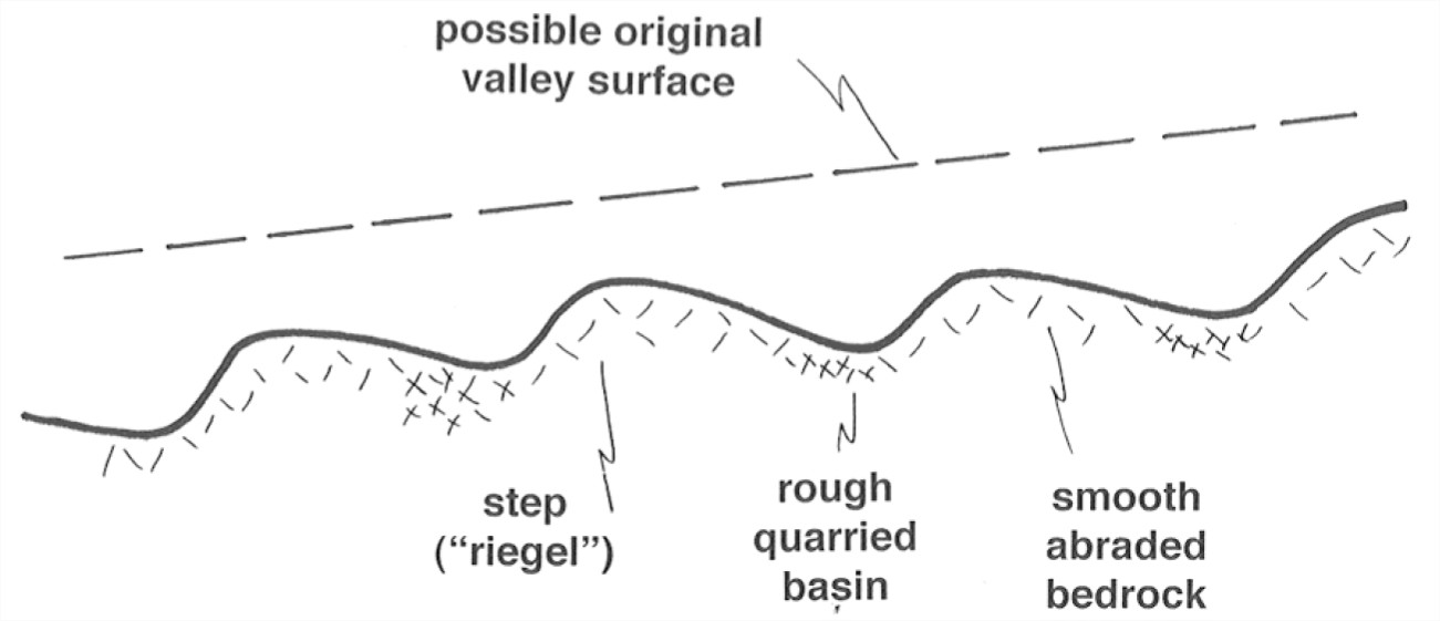
Another important line of evidence lies in the long profiles of glaciated valleys. Characteristically such profiles show large-scale steps, and even excavation of deep rock basins with up to several hundred meters of closure, now filled with glacial debris or lakes (Figure 7-40). On the assumption of regular preglacial river-valley profiles (a very good assumption), this shows that erosion rate varies greatly from place to place. Also, places where rock basins are excavated tend to have well jointed and therefore easily quarried material, whereas the bedrock highs don’t, and are therefore subject only to abrasion.

Rates of Glacial Erosion
It would be nice to be able to make an estimate of the rates of glacial erosion, and then to compare these with rates of fluvial erosion. Much effort has been expended in this direction.
There have been four major approaches to this problem: 335
• Erosion of artificial markers placed beneath a glacier (already mentioned). Problems with this approach:
— Time scales are too short.
— What about pre-weathering? (But this is a problem only if the marker is placed in an ice tunnel.)
— What about spatial non-uniformity? (The sampling grid would have to cover a large area.)
— This measures abrasion only, and by the nature of abrasion this involves too small a measurement area.
• Measure sediment transport in subglacial streams emerging from beneath a warm-based glacier. Problems with this approach:
— One needs to accumulate very long-term records and make closely spaced observations, because such streams are notoriously highly variable.
— It’s difficult (or impossible) to measure bed load.
— One has to look at moraines too; not all debris goes out in streams (but probably usually most, except in cold glaciers).
• Reconstruct the preglacial surface. Problems with this approach:
— How do you know what the preglacial surface was? There’s lots of disagreement about the criteria to use. (This approach works best in glaciated valleys, but there are problems even there.)
— Effects of glacial erosion are hard to factor out from concurrent fluvioglacial erosion and fluvial erosion during interglacial periods.
• Compute volumes of glacial drift. Problems with this approach:
— One needs to work in a very large area.
— Glacial drift grades out into fluvial and marine deposits; how do you separate out the glacial component in those deposits?
— It’s not always easy to identify the form and depth of the base of the drift.
— Later erosion of drift deposits must be taken into account.
Method 2 is probably the best, but it works only for temperate (warm) glaciers.
Some very general conclusions:
- Active temperate valley glaciers erode at much greater rates than rivers in but nonglaciated areas.
- Ice sheets (warm or cold) moving slowly over low-relief areas produced relatively low erosion even over all of the Pleistocene.
Example: the Antarctic ice sheet seems now to be eroding very slowly. Erosion probably reached a peak early, well before the Pleistocene, when the glaciers were more active and there was more material available, and it’s now slow, because of lack of easily erodible material, inactive regimen, and cold base.
Here’s some discussion on two additional specific topics in glacial erosion: glaciated valleys and cirques.
Glaciated valleys. In mountains that are not mainly the work of glaciers, preexisting valleys are modified during glaciation. In low-relief regions covered by ice sheets, often prominent valleys (now partly filled by sediments or lakes) have less obvious relation to preexisting drainage; their position is determined by preexisting drainage, but valleys become more differentiated as the glacier exploits weak rock. The Finger Lakes of New York State are an excellent example of the latter effect.
The transverse profile of glaciated valleys is commonly U-shaped: very steep or nearly vertical side walls, and gently rounded bottom. In some cases there’s even a good parabolic fit. Nonglaciated (stream) valleys in mountainous regions, on the other hand, are commonly V-shaped. Glaciated valleys have much steeper sidewalls. See Figure 7-41.
Figure 7-41. Transverse cross sections through A) a nonglaciated valley (V shaped) and B) a glaciated valley (U shaped).
The change from a V-shaped stream valley to a U-shaped stream valley could simply be by widening, or by both widening and deepening. There seems usually to be both widening and deepening. Evidence:
- Hanging tributary valleys (Figure 7-42), which even if glaciated would have far less glacial erosion. Very common.
- The long profile shows steps and rock basins, already illustrated.
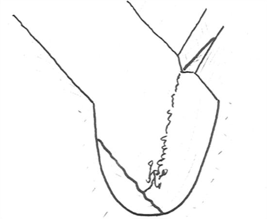
Why does a glacier develop a U-shaped valley? This is difficult to answer. Two possibilities are commonly mentioned in the literature:
• Concentration of nivation (see below) in the lower parts of valleys, as the approaching glacier weakens rocks for removal.
• Development of dilatation joints, especially in lower parts of the valley, where the ice is thicker.
Both of these effects would tend to act more in lower parts of the valley profile.
Cirques. A cirque is a rounded basin, partly enclosed by steep cliffs, cut into a mountain slope. Cirques are about circular, or at least fairly equidimensional, in plan. Their size ranges from tens of meters to several kilometers across. They can be located either at the heads of glacialed valleys or independently as indentations in smooth slopes. Cirques may or may not have (or have had) a glacier in them.
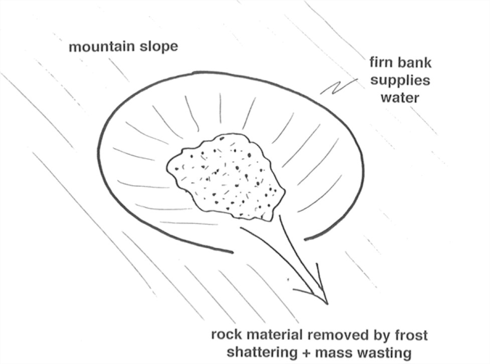
Small cirques can be formed without the presence of a glacier (Figure 7-43). Think about a firn bank that occupies a slight preexisting depression or a shady spot. Freeze–thaw cycles in the warm season result in frost wedging, and then this material moves downslope by a combination of mass wasting and surface runoff (This combination of freeze–thaw and mass wasting is called nivation.) This results in a small cirque. In such a small cirque, a firn bank acts as a passive water source.
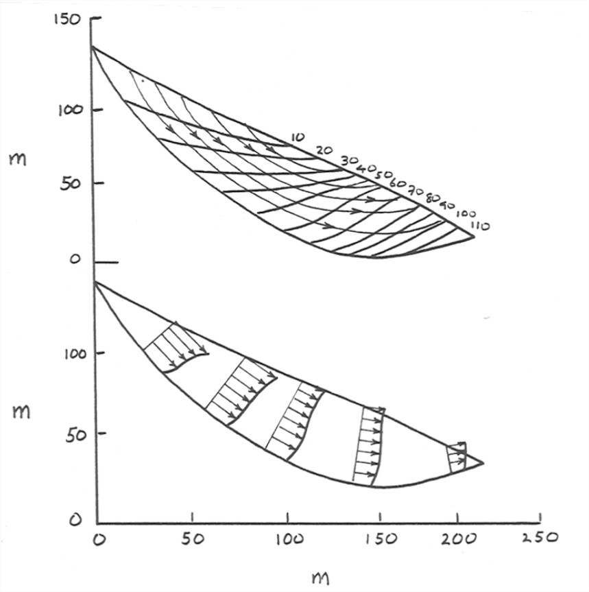
If the firn bank gets big enough, a small glacier (called a cirque glacier) is formed. Then the moving ice can enlarge the cirque to much greater size. Larger cirques tend to have a bedrock basin (often occupied by a lake after the ice melts, called a tarn, and a sill at the downslope edge (partly rock, partly moraine). Of course, large cirques grade over into the steep amphitheater-like heads of major glaciated valleys. Cirque glaciers are typically half-moon-shaped, and they move in a characteristically rotational way (see Figure 7-44, which shows the results of detailed study of a conveniently small and fairly regular cirque glacier in Norway). Note the almost circular-arc base, the almost planar surface, and the strongly rotational movement. The glacier consists of a series of ice layers separated by discontinuities (ablation textures and mineral-organic dust coatings). Most of the movement is accounted for by rotational sliding around a horizontal axis, but there is some deformation of annual layers as well.
Alpine Sculpture
Glaciation in mountainous areas tends to produce characteristic glacially sculptured landforms. The assemblage of such landforms is usually termed alpine sculpture.
As the climate in a rugged mountainous area gradually changes to become more favorable to the development of glaciers, small cirque glaciers form first and then expand to become valley glaciers. The heads of the valley glaciers may expand and merge to form extensive snowfields. Eventually an ice cap covers most or all of the mountainous area, extending out into the lowlands beyond. Then, as the climate ameliorates again, the process operates in reverse, and the glaciers shrink back to valley glaciers, then to cirque glaciers, and finally disappear altogether.
Figure 5-45 shows the sequence of glacially sculptured landforms associated with the cycle of glaciation outlined above. During the expansion of the glaciers, valleys are deepened and widened, leaving U-shaped valleys often separated by sharp cols and arêtes. Three or more large cirques at the heads of glaciated valleys may meet to for pyramidal faceted peaks known has horns.
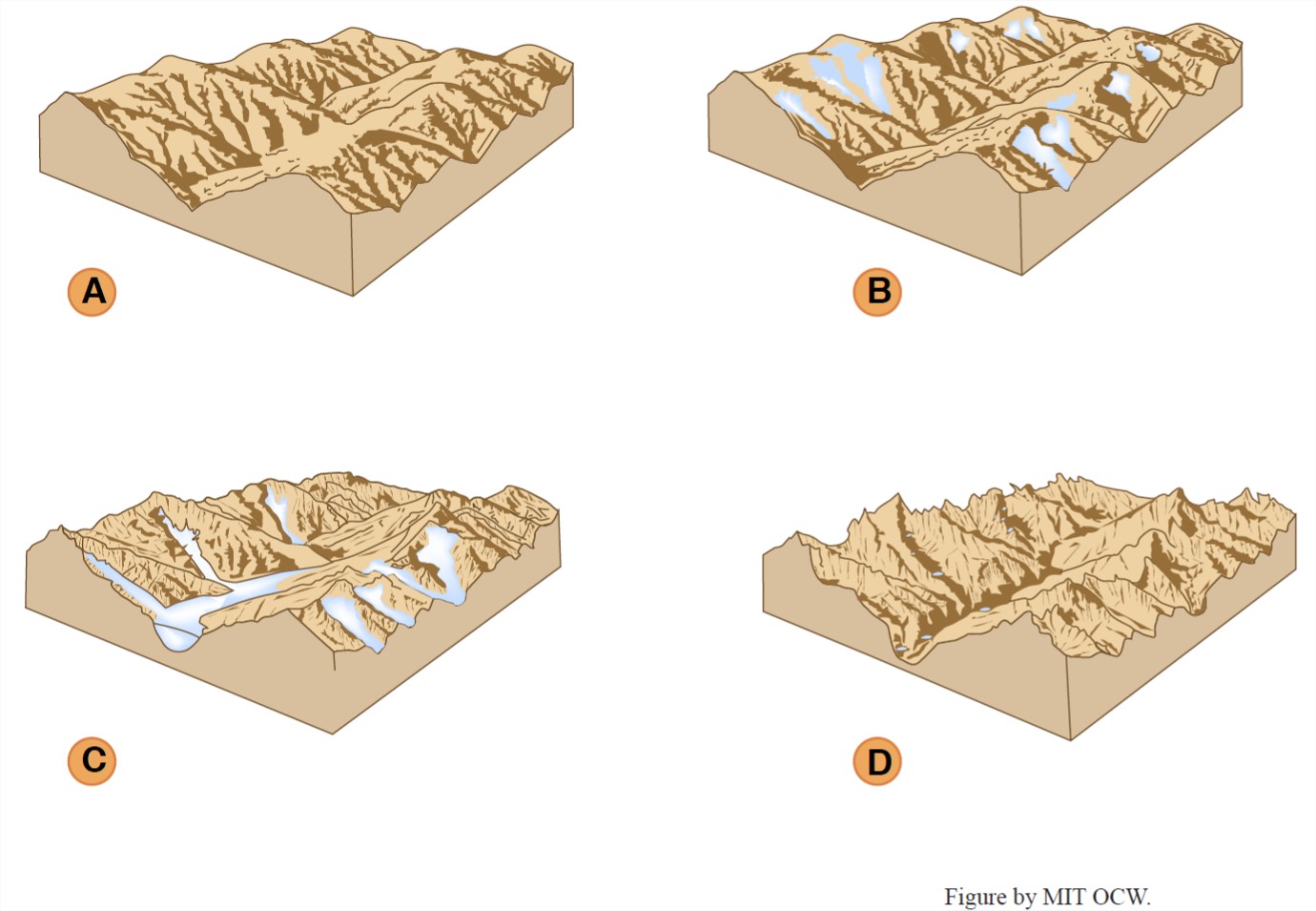
At the time of maximum glaciation, much or all of the former sharp glacially sculptured topography is smoothed as the entire area is worn by the moving ice of the ice cap. Then, as the ice caps shrink back to valley glaciers and then cirque glaciers, the mountains are sculpted once again into the landforms noted above.

