
21.2: Geological History of Canada
- Page ID
- 1801
Laurentia, which makes up the core of North America, is the largest and arguably the oldest of Earth’s cratons (regions of stable ancient crust). Some of the rocks are over 4 billion years old, and Laurentia has been together in its present form for the last billion years. Over the past 650 million years, Laurentia has moved along a zigzag path from deep in the southern hemisphere to close to the North Pole (Figure 21.1.1). During that time, it collided several times with other continents and was temporarily part of two supercontinents (Pannotia and Pangea).
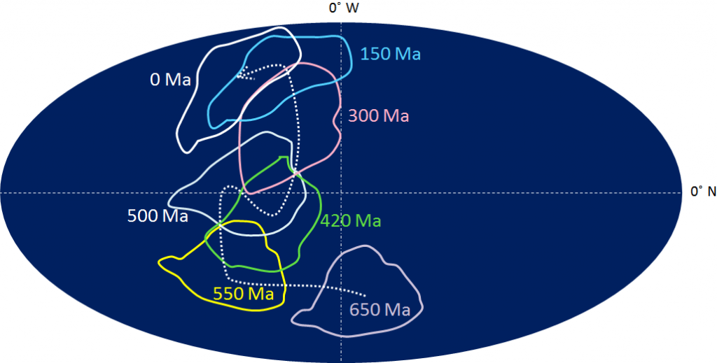
Figure 21.1.1 The path of Laurentia over the past 650 Ma [SE]
Bodies of rock tend to be eroded and recycled through the processes of plate tectonics, including uplift leading to erosion and burial leading to melting, and thus there are very few areas of truly ancient rocks on Earth. The oldest undisputed rocks are those of the Acasta Gneiss from north of Yellowknife, Northwest Territories, aged 4.03 Ga. But there are some rocks that could be even older within the Nuvvuagittuq greenstone belt on the east coast of Hudson Bay, in Quebec. These have been isotopically dated at 4.28 Ga, although the reliability of that date has been questioned. Based on other data, it is acknowledged that the Nuvvuagittuq rocks are at least as old as 3.75 Ga. The Acasta and Nuvvuagittuq rocks are situated within the Slave and Superior Cratons respectively, the oldest parts of Laurentia (Figure 21.1.2). Although these ancient cratons are not consistently that old, they are generally older than 3 Ga, as is part of the Wyoming Craton. The Hearne and Rae Cratons are older than 2 Ga, while most of the other parts of Laurentia are aged between 1 Ga and 2 Ga. The various provinces of Laurentia were assembled by plate-tectonic processes between 1 Ga and 3 Ga.
The areas of Figure 21.1.2 that are left uncoloured — the Appalachian, Innuitian, and Cordilleran fold belts — are geological regions that have been added to North America since 500 Ma. These are at least partly made up of sedimentary rocks that were deposited along the coasts and then folded, faulted, and uplifted during continental collisions.
The term Laurentia is geologically equivalent to the term Canadian Shield, although the latter is generally considered to be the area where the ancient Laurentian rocks are exposed at the surface and not covered with younger rocks. That applies to most of the region to the north and east of the red dotted line in Figure 21.1.2.
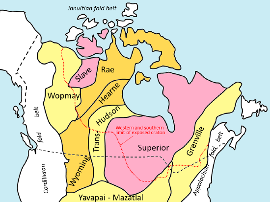
Figure 21.1.2 The main provinces of Laurentia. The pink areas are the oldest; light yellow are the youngest. All of the areas south and west of the dotted red line are now covered with younger rocks. The white areas represent rocks that were added to North America since 700 Ma. [SE]
Laurentia was part of the supercontinent Rodinia during the period between 1,100 Ma and 700 Ma. As Rodinia started to break up after 700 Ma, sediments derived from the erosion of the interior of the continent began to accumulate along its coasts, initially along the west coast, then the east coast at around 600 Ma, and finally on the north coast by around 550 Ma. This process continued for several hundred million years. By around 450 Ma, large areas of the interior of Laurentia were depressed below sea level — probably because of the downward pull of an underlying subducting plate — and marine sediments were deposited over parts of Quebec, Ontario, Manitoba, Saskatchewan, Alberta, and the Northwest Territories during the Ordovician, Silurian, and Devonian Periods (450 Ma to 350 Ma). These sediments are coloured various shades of blue on the geological map of Canada (Figure 21.1.3).
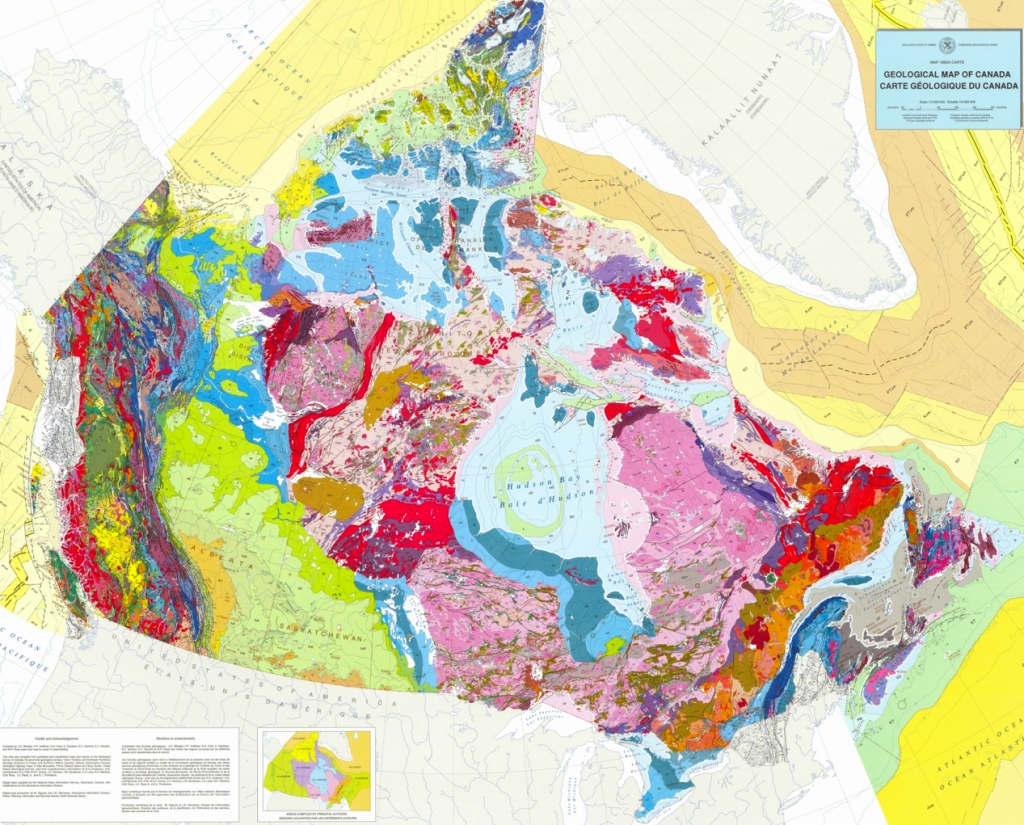
Figure 21.1.3 Geological map of Canada from the Geological Survey of Canada [http://geoscan.nrcan.gc.ca/starweb/g...rch1=R=208175]
At approximately 350 Ma, the part of Gondwana that is now Africa collided with the eastern coast of North America, thrusting volcanic islands and sedimentary layers far inland to become the Appalachian fold belt. The Appalachian Mountains would have rivalled the Himalayas in extent and height during the Devonian. At about the same time, a smaller continent, Pearya, collided with the north coast, creating the Innuitian fold belt.
At around 200 Ma, small continents that now make up the interior of B.C. and part of Yukon collided with the west coast of North America, starting the process of thrusting the sedimentary rocks inland and upward to form the Rocky Mountains.
The west-central part of North America subsided once again at around 150 Ma, due to an underlying subducting plate, and this led to the deposition of more marine rocks across Manitoba, Saskatchewan, and Alberta, and north into the Northwest Territories and Yukon (the green areas in Figure 21.1.2).
Finally, at around 90 Ma, more small continents, which now comprise Vancouver Island and Haida Gwaii, collided with the west coast, leading to further uplift of the Rocky Mountains.
Exercise 21.1 Finding the Geological Provinces of Canada
Figure 21.1.3 shows the geology of Canada in some detail, with the colours representing the lithologies and ages of the rocks. Identifying in Figure 21.1.3 some of the major features shown in Figure 21.1.2 will help you understand the distribution of Canada’s geological features. Start by outlining the extent of the exposed Canadian Shield (the dotted red line); you might also be able to identify some of the cratons within the Shield. Then look for the limits of the Appalachian and Innuitian fold belts. Finally pick out the extent of the Cordilleran fold belt.
The best way to do this would be to print out a copy of Figure 21.1.3 and draw the boundaries from Figure 21.1.2 on it with a pencil. If you’re interested, you can get your own high resolution copy of the geological map of Canada at http://geoscan.nrcan.gc.ca/starweb/g...arch1=R=208175.
Contributors
-
Physical Geology by Steven Earle used under a CC-BY 4.0 international license. Download this book for free at http://open.bccampus.ca.