
12.2: Controls of Climate
- Page ID
- 12872
\( \newcommand{\vecs}[1]{\overset { \scriptstyle \rightharpoonup} {\mathbf{#1}} } \)
\( \newcommand{\vecd}[1]{\overset{-\!-\!\rightharpoonup}{\vphantom{a}\smash {#1}}} \)
\( \newcommand{\id}{\mathrm{id}}\) \( \newcommand{\Span}{\mathrm{span}}\)
( \newcommand{\kernel}{\mathrm{null}\,}\) \( \newcommand{\range}{\mathrm{range}\,}\)
\( \newcommand{\RealPart}{\mathrm{Re}}\) \( \newcommand{\ImaginaryPart}{\mathrm{Im}}\)
\( \newcommand{\Argument}{\mathrm{Arg}}\) \( \newcommand{\norm}[1]{\| #1 \|}\)
\( \newcommand{\inner}[2]{\langle #1, #2 \rangle}\)
\( \newcommand{\Span}{\mathrm{span}}\)
\( \newcommand{\id}{\mathrm{id}}\)
\( \newcommand{\Span}{\mathrm{span}}\)
\( \newcommand{\kernel}{\mathrm{null}\,}\)
\( \newcommand{\range}{\mathrm{range}\,}\)
\( \newcommand{\RealPart}{\mathrm{Re}}\)
\( \newcommand{\ImaginaryPart}{\mathrm{Im}}\)
\( \newcommand{\Argument}{\mathrm{Arg}}\)
\( \newcommand{\norm}[1]{\| #1 \|}\)
\( \newcommand{\inner}[2]{\langle #1, #2 \rangle}\)
\( \newcommand{\Span}{\mathrm{span}}\) \( \newcommand{\AA}{\unicode[.8,0]{x212B}}\)
\( \newcommand{\vectorA}[1]{\vec{#1}} % arrow\)
\( \newcommand{\vectorAt}[1]{\vec{\text{#1}}} % arrow\)
\( \newcommand{\vectorB}[1]{\overset { \scriptstyle \rightharpoonup} {\mathbf{#1}} } \)
\( \newcommand{\vectorC}[1]{\textbf{#1}} \)
\( \newcommand{\vectorD}[1]{\overrightarrow{#1}} \)
\( \newcommand{\vectorDt}[1]{\overrightarrow{\text{#1}}} \)
\( \newcommand{\vectE}[1]{\overset{-\!-\!\rightharpoonup}{\vphantom{a}\smash{\mathbf {#1}}}} \)
\( \newcommand{\vecs}[1]{\overset { \scriptstyle \rightharpoonup} {\mathbf{#1}} } \)
\( \newcommand{\vecd}[1]{\overset{-\!-\!\rightharpoonup}{\vphantom{a}\smash {#1}}} \)
\(\newcommand{\avec}{\mathbf a}\) \(\newcommand{\bvec}{\mathbf b}\) \(\newcommand{\cvec}{\mathbf c}\) \(\newcommand{\dvec}{\mathbf d}\) \(\newcommand{\dtil}{\widetilde{\mathbf d}}\) \(\newcommand{\evec}{\mathbf e}\) \(\newcommand{\fvec}{\mathbf f}\) \(\newcommand{\nvec}{\mathbf n}\) \(\newcommand{\pvec}{\mathbf p}\) \(\newcommand{\qvec}{\mathbf q}\) \(\newcommand{\svec}{\mathbf s}\) \(\newcommand{\tvec}{\mathbf t}\) \(\newcommand{\uvec}{\mathbf u}\) \(\newcommand{\vvec}{\mathbf v}\) \(\newcommand{\wvec}{\mathbf w}\) \(\newcommand{\xvec}{\mathbf x}\) \(\newcommand{\yvec}{\mathbf y}\) \(\newcommand{\zvec}{\mathbf z}\) \(\newcommand{\rvec}{\mathbf r}\) \(\newcommand{\mvec}{\mathbf m}\) \(\newcommand{\zerovec}{\mathbf 0}\) \(\newcommand{\onevec}{\mathbf 1}\) \(\newcommand{\real}{\mathbb R}\) \(\newcommand{\twovec}[2]{\left[\begin{array}{r}#1 \\ #2 \end{array}\right]}\) \(\newcommand{\ctwovec}[2]{\left[\begin{array}{c}#1 \\ #2 \end{array}\right]}\) \(\newcommand{\threevec}[3]{\left[\begin{array}{r}#1 \\ #2 \\ #3 \end{array}\right]}\) \(\newcommand{\cthreevec}[3]{\left[\begin{array}{c}#1 \\ #2 \\ #3 \end{array}\right]}\) \(\newcommand{\fourvec}[4]{\left[\begin{array}{r}#1 \\ #2 \\ #3 \\ #4 \end{array}\right]}\) \(\newcommand{\cfourvec}[4]{\left[\begin{array}{c}#1 \\ #2 \\ #3 \\ #4 \end{array}\right]}\) \(\newcommand{\fivevec}[5]{\left[\begin{array}{r}#1 \\ #2 \\ #3 \\ #4 \\ #5 \\ \end{array}\right]}\) \(\newcommand{\cfivevec}[5]{\left[\begin{array}{c}#1 \\ #2 \\ #3 \\ #4 \\ #5 \\ \end{array}\right]}\) \(\newcommand{\mattwo}[4]{\left[\begin{array}{rr}#1 \amp #2 \\ #3 \amp #4 \\ \end{array}\right]}\) \(\newcommand{\laspan}[1]{\text{Span}\{#1\}}\) \(\newcommand{\bcal}{\cal B}\) \(\newcommand{\ccal}{\cal C}\) \(\newcommand{\scal}{\cal S}\) \(\newcommand{\wcal}{\cal W}\) \(\newcommand{\ecal}{\cal E}\) \(\newcommand{\coords}[2]{\left\{#1\right\}_{#2}}\) \(\newcommand{\gray}[1]{\color{gray}{#1}}\) \(\newcommand{\lgray}[1]{\color{lightgray}{#1}}\) \(\newcommand{\rank}{\operatorname{rank}}\) \(\newcommand{\row}{\text{Row}}\) \(\newcommand{\col}{\text{Col}}\) \(\renewcommand{\row}{\text{Row}}\) \(\newcommand{\nul}{\text{Nul}}\) \(\newcommand{\var}{\text{Var}}\) \(\newcommand{\corr}{\text{corr}}\) \(\newcommand{\len}[1]{\left|#1\right|}\) \(\newcommand{\bbar}{\overline{\bvec}}\) \(\newcommand{\bhat}{\widehat{\bvec}}\) \(\newcommand{\bperp}{\bvec^\perp}\) \(\newcommand{\xhat}{\widehat{\xvec}}\) \(\newcommand{\vhat}{\widehat{\vvec}}\) \(\newcommand{\uhat}{\widehat{\uvec}}\) \(\newcommand{\what}{\widehat{\wvec}}\) \(\newcommand{\Sighat}{\widehat{\Sigma}}\) \(\newcommand{\lt}{<}\) \(\newcommand{\gt}{>}\) \(\newcommand{\amp}{&}\) \(\definecolor{fillinmathshade}{gray}{0.9}\)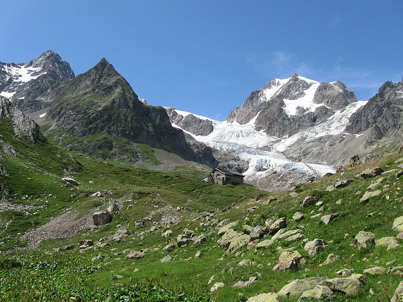 Although almost anything can happen with the weather, climate is more predictable. The weather on a particular winter day in San Diego may be colder than on the same day in Lake Tahoe, but, on average, Tahoe’s winter climate is significantly colder than San Diego’s. Climate then is the long-term average of weather. Good climate is why we choose to vacation in Hawaii in February, even though the weather is not guaranteed to be good!
Climate is the average of weather in that location over a long period of time, usually for at least 30 years. A location’s climate can be described by its air temperature, humidity, wind speed and direction, and the type, quantity, and frequency of precipitation. Climate can change, but only over long periods of time. The climate of a region depends on its position relative to many things. These factors are described in the next sections.
Latitude
The main factor influencing the climate of a region is latitude because different latitudes receive different amounts of solar radiation. To review from the Earth’s Atmosphere chapter:
- The equator receives the most solar radiation. Days are equally long year-round and the sun is just about directly overhead at midday.
- The polar regions receive the least solar radiation. The night lasts six months during the winter. Even in summer, the sun never rises very high in the sky. Sunlight filters through a thick wedge of atmosphere, making the sunlight much less intense. The high albedo, because of ice and snow, reflects a good portion of the sun’s light.
Atmospheric Circulation
Recall from the Earth’s Atmosphere chapter the circulation cells and global wind belts. The position of a region relative to the circulation cells and wind belts has a great effect on its climate. In an area where the air is mostly rising or sinking, there is not much wind.
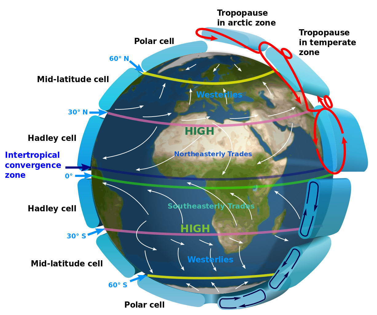
Intertropical Convergence Zone
The Intertropical Convergence Zone (ITCZ) is the low pressure area near the equator in the boundary between the two Hadley Cells. The air rises so that it cools and condenses to create clouds and rain. Climate along the ITCZ is therefore warm and wet. Early mariners called this region the doldrums because their ships were often unable to sail because there were no steady winds.
The ITCZ migrates slightly with the season. Land areas heat more quickly than the oceans. Because there are more land areas in the Northern Hemisphere, the ITCZ is influenced by the heating effect of the land. In Northern Hemisphere summer, it is approximately 5o north of the equator while in the winter it shifts back and is approximately at the equator. As the ITCZ shifts, the major wind belts also shift slightly north in summer and south in winter, which causes the wet and dry seasons in this area.
Hadley Cell and Ferrel Cell Boundaries
At about 30 degrees N and 30 degrees S, the air is fairly warm and dry because much of it came from the equator where it lost most of its moisture at the ITCZ. At this location the air is descending, and sinking air warms and causes evaporation.
Mariners named this region the horse latitudes. Sailing ships were sometimes delayed for so long by the lack of wind that they would run out of water and food for their livestock. Sailors tossed horses and other animals over the side after they died. Sailors sometimes didn’t make it either.
Prevailing Winds
The prevailing winds are the bases of the Hadley, Ferrell, and Polar Cells. These winds greatly influence the climate of a region because they bring the weather from the locations they come from. For example, in California, the predominant winds are the westerlies blowing in from the Pacific Ocean, which bring in relatively cool air in summer and relatively warm air in winter. Local winds also influence local climate. For example, land breezes and sea breezes moderate coastal temperatures.
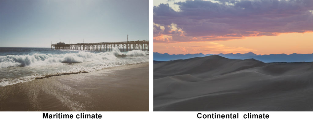
Continental Position
When a particular location is near an ocean or large lake, the body of water plays an extremely important role in affecting the region’s climate.
- A maritime climate is strongly influenced by the nearby sea. Temperatures vary a relatively small amount seasonally and daily. For a location to have a true maritime climate, the winds must most frequently come off the sea.
- A continental climate is more extreme, with greater temperature differences between day and night and between summer and winter.
The ocean’s influence in moderating climate can be seen in the following temperature comparisons. Each of these cities is located at 37 ºN latitude, within the westerly winds.
Ocean Currents
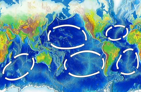
The temperature of the water offshore influences the temperature of a coastal location, particularly if the winds come off the sea. The cool waters of along the western United States is caused by a clockwise rotating ocean current that is bringing cold water from the arctic toward the equator. The climatic effect is that coastal regions of California, Oregon, and Washington are are cool. Coastal upwelling also brings cold, deep water up to the ocean surface off of California, which contributes to the cool coastal temperatures. But that same ocean current brings warm, tropical water to eastern Japan.In the Atlantic Ocean, the northern ocean current, called the Gulf Stream, brings warm water from the tropics to the southern states. This is a major reason why the southern states experience humid conditions in the summer and tornadoes because of all this warm moisture. The Gulf Stream also impacts Europe by bringing warm water northward, making this region that is rather northward warmer than expected.
Altitude and Mountain Ranges
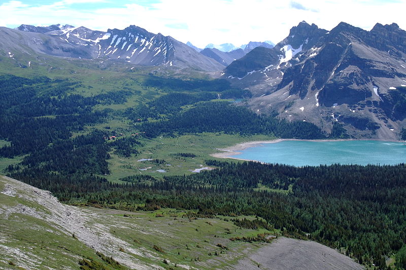 Air pressure and air temperature decreases with altitude. The closer molecules are packed together, the more likely they are to collide. Collisions between molecules give off heat, which warms the air. At higher altitudes, the air is less dense and air molecules are more spread out and less likely to collide. A location in the mountains has lower average temperatures than one at the base of the mountains. In Colorado, for example, Lakewood (5,640 feet) average annual temperature is 62 degrees F (17 degrees C), while Climax Lake (11,300 feet) is 42 degrees F (5.4 degrees C).
Mountain ranges have two effects on the climate of the surrounding region. The first is something called the rainshadow effect, which brings warm dry climate to the leeward size of a mountain range, was described in the Earth’s Atmosphere chapter. The second effect mountains have on climate systems is the ability to separate coastal regions from the rest of the continent. Since a maritime air mass may have trouble rising over a mountain range, the coastal area will have a maritime climate but the inland area on the leeward side will have a continental climate.
- Dynamic Earth: Introduction to Physical Geography. Authored by: R. Adam Dastrup. Located at: http://www.opengeography.org/physical-geography.html. Project: Open Geography Education. License: CC BY-SA: Attribution-ShareAlike
- Earth Global Circulation. Authored by: Kaidor. Located at: https://commons.wikimedia.org/wiki/File:Earth_Global_Circulation_-_en.svg. License: CC BY-SA: Attribution-ShareAlike
- Beach. Authored by: BarnImages. Located at: https://pixabay.com/en/beach-pier-ocean-water-sea-summer-820083/. License: CC0: No Rights Reserved
- #conservationlands15 Social Media Takeover, Dec 15th, Top 15 Film Locations on National Conservation Lands. Authored by: Bureau of Land Management. Located at: https://flic.kr/p/C4Pgrd. License: CC BY: Attribution
- Mount Assiniboine Provincial Park Lodge. Authored by: Kurt Stegmuller. Located at: https://commons.wikimedia.org/wiki/File:Mount_Assiniboine_Provincial_Park_Lodge.jpg. License: CC BY-SA: Attribution-ShareAlike
- Rifugio Elisabetta Soldini. Authored by: Rollopack. Located at: https://commons.wikimedia.org/wiki/File:Rifugio_Elisabetta_Soldini.jpg. License: Public Domain: No Known Copyright
- Oceanic gyres. Provided by: NOAA. Located at: https://commons.wikimedia.org/wiki/File:Oceanic_gyres.png. License: Public Domain: No Known Copyright