
4.5: The Role of State and Local Government
- Page ID
- 6757
\( \newcommand{\vecs}[1]{\overset { \scriptstyle \rightharpoonup} {\mathbf{#1}} } \)
\( \newcommand{\vecd}[1]{\overset{-\!-\!\rightharpoonup}{\vphantom{a}\smash {#1}}} \)
\( \newcommand{\id}{\mathrm{id}}\) \( \newcommand{\Span}{\mathrm{span}}\)
( \newcommand{\kernel}{\mathrm{null}\,}\) \( \newcommand{\range}{\mathrm{range}\,}\)
\( \newcommand{\RealPart}{\mathrm{Re}}\) \( \newcommand{\ImaginaryPart}{\mathrm{Im}}\)
\( \newcommand{\Argument}{\mathrm{Arg}}\) \( \newcommand{\norm}[1]{\| #1 \|}\)
\( \newcommand{\inner}[2]{\langle #1, #2 \rangle}\)
\( \newcommand{\Span}{\mathrm{span}}\)
\( \newcommand{\id}{\mathrm{id}}\)
\( \newcommand{\Span}{\mathrm{span}}\)
\( \newcommand{\kernel}{\mathrm{null}\,}\)
\( \newcommand{\range}{\mathrm{range}\,}\)
\( \newcommand{\RealPart}{\mathrm{Re}}\)
\( \newcommand{\ImaginaryPart}{\mathrm{Im}}\)
\( \newcommand{\Argument}{\mathrm{Arg}}\)
\( \newcommand{\norm}[1]{\| #1 \|}\)
\( \newcommand{\inner}[2]{\langle #1, #2 \rangle}\)
\( \newcommand{\Span}{\mathrm{span}}\) \( \newcommand{\AA}{\unicode[.8,0]{x212B}}\)
\( \newcommand{\vectorA}[1]{\vec{#1}} % arrow\)
\( \newcommand{\vectorAt}[1]{\vec{\text{#1}}} % arrow\)
\( \newcommand{\vectorB}[1]{\overset { \scriptstyle \rightharpoonup} {\mathbf{#1}} } \)
\( \newcommand{\vectorC}[1]{\textbf{#1}} \)
\( \newcommand{\vectorD}[1]{\overrightarrow{#1}} \)
\( \newcommand{\vectorDt}[1]{\overrightarrow{\text{#1}}} \)
\( \newcommand{\vectE}[1]{\overset{-\!-\!\rightharpoonup}{\vphantom{a}\smash{\mathbf {#1}}}} \)
\( \newcommand{\vecs}[1]{\overset { \scriptstyle \rightharpoonup} {\mathbf{#1}} } \)
\( \newcommand{\vecd}[1]{\overset{-\!-\!\rightharpoonup}{\vphantom{a}\smash {#1}}} \)
\(\newcommand{\avec}{\mathbf a}\) \(\newcommand{\bvec}{\mathbf b}\) \(\newcommand{\cvec}{\mathbf c}\) \(\newcommand{\dvec}{\mathbf d}\) \(\newcommand{\dtil}{\widetilde{\mathbf d}}\) \(\newcommand{\evec}{\mathbf e}\) \(\newcommand{\fvec}{\mathbf f}\) \(\newcommand{\nvec}{\mathbf n}\) \(\newcommand{\pvec}{\mathbf p}\) \(\newcommand{\qvec}{\mathbf q}\) \(\newcommand{\svec}{\mathbf s}\) \(\newcommand{\tvec}{\mathbf t}\) \(\newcommand{\uvec}{\mathbf u}\) \(\newcommand{\vvec}{\mathbf v}\) \(\newcommand{\wvec}{\mathbf w}\) \(\newcommand{\xvec}{\mathbf x}\) \(\newcommand{\yvec}{\mathbf y}\) \(\newcommand{\zvec}{\mathbf z}\) \(\newcommand{\rvec}{\mathbf r}\) \(\newcommand{\mvec}{\mathbf m}\) \(\newcommand{\zerovec}{\mathbf 0}\) \(\newcommand{\onevec}{\mathbf 1}\) \(\newcommand{\real}{\mathbb R}\) \(\newcommand{\twovec}[2]{\left[\begin{array}{r}#1 \\ #2 \end{array}\right]}\) \(\newcommand{\ctwovec}[2]{\left[\begin{array}{c}#1 \\ #2 \end{array}\right]}\) \(\newcommand{\threevec}[3]{\left[\begin{array}{r}#1 \\ #2 \\ #3 \end{array}\right]}\) \(\newcommand{\cthreevec}[3]{\left[\begin{array}{c}#1 \\ #2 \\ #3 \end{array}\right]}\) \(\newcommand{\fourvec}[4]{\left[\begin{array}{r}#1 \\ #2 \\ #3 \\ #4 \end{array}\right]}\) \(\newcommand{\cfourvec}[4]{\left[\begin{array}{c}#1 \\ #2 \\ #3 \\ #4 \end{array}\right]}\) \(\newcommand{\fivevec}[5]{\left[\begin{array}{r}#1 \\ #2 \\ #3 \\ #4 \\ #5 \\ \end{array}\right]}\) \(\newcommand{\cfivevec}[5]{\left[\begin{array}{c}#1 \\ #2 \\ #3 \\ #4 \\ #5 \\ \end{array}\right]}\) \(\newcommand{\mattwo}[4]{\left[\begin{array}{rr}#1 \amp #2 \\ #3 \amp #4 \\ \end{array}\right]}\) \(\newcommand{\laspan}[1]{\text{Span}\{#1\}}\) \(\newcommand{\bcal}{\cal B}\) \(\newcommand{\ccal}{\cal C}\) \(\newcommand{\scal}{\cal S}\) \(\newcommand{\wcal}{\cal W}\) \(\newcommand{\ecal}{\cal E}\) \(\newcommand{\coords}[2]{\left\{#1\right\}_{#2}}\) \(\newcommand{\gray}[1]{\color{gray}{#1}}\) \(\newcommand{\lgray}[1]{\color{lightgray}{#1}}\) \(\newcommand{\rank}{\operatorname{rank}}\) \(\newcommand{\row}{\text{Row}}\) \(\newcommand{\col}{\text{Col}}\) \(\renewcommand{\row}{\text{Row}}\) \(\newcommand{\nul}{\text{Nul}}\) \(\newcommand{\var}{\text{Var}}\) \(\newcommand{\corr}{\text{corr}}\) \(\newcommand{\len}[1]{\left|#1\right|}\) \(\newcommand{\bbar}{\overline{\bvec}}\) \(\newcommand{\bhat}{\widehat{\bvec}}\) \(\newcommand{\bperp}{\bvec^\perp}\) \(\newcommand{\xhat}{\widehat{\xvec}}\) \(\newcommand{\vhat}{\widehat{\vvec}}\) \(\newcommand{\uhat}{\widehat{\uvec}}\) \(\newcommand{\what}{\widehat{\wvec}}\) \(\newcommand{\Sighat}{\widehat{\Sigma}}\) \(\newcommand{\lt}{<}\) \(\newcommand{\gt}{>}\) \(\newcommand{\amp}{&}\) \(\definecolor{fillinmathshade}{gray}{0.9}\)“. . .earthquakes, faults, the people who study them, and the social institutions that grapple with how to foil the natural terrorist beneath us.”
Lisa B. Grant, University of California Irvine,
in her review of Living with Earthquakes in California,
in Transactions of the American Geophysical Union
1. Introduction
Although the president can declare a disaster without consulting the governor or local officials, the role of the federal government is largely advisory. It is the states and their counties, cities, and multi-city governments that must establish and carry out policy regarding earthquakes. The USGS can advise the governor about earthquakes, and NOAA can advise about tsunamis, but the final call must be from the governor and from local elected officials.
This chapter reviews the institutions that carry out earthquake policies in the three west coast states and the province of British Columbia. We start with California, which has experienced more losses from earthquakes in the last century, and has dealt with them to a greater degree, than the other states or British Columbia. California is a pace-setter for fashion, music, and technology; and it is also a pace-setter in strengthening society against earthquakes.
2. California
In 1853, five years after the start of the Gold Rush, a state geological survey was organized, with a prominent physician and geologist, John B. Trask, as the first state geologist. Three years later, Trask, also a cofounder of the California Academy of Natural Sciences, began publishing compilations of earthquakes that had struck California. This was not to alert people to the hazard, but to show “that California quakes were no more severe or frequent than those felt on the East Coast.” Trask’s geological survey expired but was followed in 1860 by a second state geological survey headed by Josiah D. Whitney. Whitney visited the area most heavily damaged in the 1872 Owens Valley Earthquake—the first time an earthquake had been studied by a scientist employed by the state. But Whitney’s style was abrasive, and he was more interested in studying fossils whereas the legislature wanted him to work on gold deposits. No one saw any value in studying earthquakes, so Whitney and his state geological survey were put out of business in 1874.
There was still interest in mining, though, and a state mining bureau was established in 1880, headed by a state mineralogist. This arrangement stayed in place until 1929, when the organization was renamed the Division of Mines and placed under the new Department of Natural Resources, under the supervision of the Mining Board. In that same year, the division hired its first geologist, whose assignment was to make a new geological map of the state. In 1961, the Division of Mines was renamed Division of Mines and Geology and placed under the Department of Conservation. Its head was named the state geologist, the first with that title since Whitney.
But the legislative charge to the division, like the USGS at the federal level, continued to be on mineral resources, although its geological staff had the expertise to work on environmental problems such as landslides and earthquakes. Things began to change in 1948, when Gordon B. Oakeshott was hired. Oakeshott and his family had been badly shaken by the Long Beach Earthquake of 1933, while he was completing his PhD studies on the San Fernando Valley and western San Gabriel Mountains. Oakeshott was captivated by earthquakes, and he carried this fascination to his new job with the state.
Oakeshott’s chance came with the Kern County Earthquake of July 21, 1952, which he visited. At a meeting at Caltech, the Division of Mines agreed to publish a report to be edited by Oakeshott containing all the major scientific contributions from universities and government agencies alike. After the publication of this report in 1955, Oakeshott took the lead in earthquake studies within the division, even though there was no clear authority from the legislature or the Mining Board for the division to do so.
In 1959, Ian Campbell, a widely respected professor of geology at Caltech, became the new chief of the division. By focusing on mining, the division had mainly served the rural counties of the state, but Campbell believed that it should serve the cities as well. Urban sprawl was eliminating valuable deposits of sand and gravel, and Campbell justified an urban geology program to the Mining Board by calling it an assessment of sand and gravel resources around major cities. In 1960, he started a mapping program in an area near Los Angeles where landslides had been destroying expensive homes. Following the 1964 Alaska Earthquake, Campbell received approval from the board to start an urban hazards mapping program, including earthquake shaking, and to begin studies of the San Andreas Fault.
The Mining Board was reconstituted as the State Mining and Geology Board, and new appointees included earthquake geologist Clarence Allen, engineering geologist Richard Jahns, and earthquake engineer Karl Steinbrugge—all supporters of earthquake research. The division has now returned to its nineteenth-century name, the California Geological Survey.
A broad-based earthquake program was started with a budget of $260,000 in 1969 (one-fifth of the division’s total budget), increasing to more than $400,000 the following year. The popular division publication, Mineral Information Service (renamed California Geology in 1971), began to publish articles on earthquakes that were easy for the general public to read. (This publication was discontinued in 2002 as a result of a budget crisis.) At the request of the California Disaster Office (later the Governor’s Office of Emergency Services), the division published a map showing where earthquake damage could be expected. In 1970, an agreement was reached with the Division of Real Estate to review all proposals for subdividing land, about fourteen hundred per year. The Division of Mines and Geology recommended that, where appropriate, the Division of Real Estate should include a notice of possible earthquake hazard or other geologic hazard in its report to the public.
In 1969, following an earthquake-prediction scare in the Bay Area, State Senator Alfred Alquist of San Jose persuaded the legislature to appoint a Joint Committee on Seismic Safety, with himself as chairman. This legislative committee would be a driving force for earthquake legislation in the following decade. On February 9, 1971, the Sylmar Earthquake struck the San Fernando Valley, which Oakeshott had mapped as a PhD student. This earthquake produced unusually high accelerations, leading structural engineers to request more information on the strong motion of earthquakes. In addition, a previously unrecognized reverse fault cut across housing developments, roads, and freeways, causing great damage. It became clear that the Field and Riley acts, which had been passed after the 1933 Long Beach Earthquake, were not adequate to regulate building construction. In addition, there was no requirement that active faults be taken into consideration in approving housing developments for construction.
Alquist’s Joint Committee on Seismic Safety heard recommendations resulting from the 1971 earthquake, including one that the state establish a program to measure strong ground shaking during earthquakes. This program was assigned to the Division of Mines and Geology and paid for by an assessment of 0.0007 percent of the value of new construction as part of the cost of the building permit—all except for Los Angeles and San Francisco, which already had such an assessment. The bill creating the Strong Motion Instrumentation Program was signed into law by Governor Ronald Reagan in October 1971. In the first three years of this program, the Division received nearly $1.25 million, an increase in its budget of about 25 percent.
Another law passed in 1971 was the requirement that cities and counties include a seismic safety element as one of the components of their general plan, adding earthquakes to other natural and urban hazards. This was an outgrowth of a requirement put into place in 1937 and beefed up in 1955 that each city and county adopt a general plan to guide decisions regarding long-term development. The Division of Mines and Geology, along with other agencies, helped develop guidelines for preparing seismic safety elements and assisted several counties in preparing their plans, including emergency response plans, a plan for reducing hazards from old, unsafe buildings; and a map of local seismic hazards. However, most local agencies did not develop procedures for building permit review, which are necessary to implement the hazard-reduction policies of their general plans.
What about active faults, like the fault that had ruptured in the 1971 earthquake and damaged or destroyed buildings on top of it? Developers in the San Francisco Bay Area were building directly across faults that were known to be active. Geologist Clarence Allen of Caltech argued that the most likely place for a future fault rupture is where the fault has ruptured in the past. Evidence for past rupture could be determined by geological investigations.
Two months after the Sylmar Earthquake, Sen. Alquist, through the Joint Committee on Seismic Safety, introduced a bill to require the state geologist to identify zones centered on the San Andreas Fault and other well-defined active faults, calling for special measures before construction on these zones could take place. Assemblyman Paul Priolo of Los Angeles introduced a similar bill, but both bills died in committee. The next year, both Alquist and Priolo revised their bills with advice from the Joint Committee on Seismic Safety and the Division of Mines and Geology. Compromise was necessary to get the support of local government lobbying groups, including adding an urban planner and a representative of county government to the State Mining and Geology Board. The final bill, renamed the Alquist-Priolo Geologic Hazard Zone Act, was signed into law by Governor Reagan in late 1972.
In the following year, guidelines for cities and counties were drawn up by the Mining and Geology Board defining an active fault under the new law. An Alquist-Priolo fault must have evidence of movement in the past eleven thousand years, the age of the Holocene Epoch following the Ice Ages. A geologic report on the presence of active faults was required prior to development in an Alquist-Priolo zone. The law established setbacks from the fault that would be off limits for construction. The setback could be widened or narrowed based on the recommendation of the geologist; a wider zone might be mandated based on a broader fault zone or on uncertainty in locating the fault. Another provision of the law was that a seller was required to inform a potential buyer that the property for sale lies in an Alquist-Priolo zone.
When the first fault maps appeared in late 1973, they were criticized because they “amount[ed] to libel of title to the lands inclosed” and “deprive[d] land owners of their property rights without due process of law.” In response to this opposition, single-family homes not part of a subdivision (four or more lots) and buildings with up to three living units were excluded from the law, and the law was renamed the “Alquist-Priolo Special Studies Zone Act,” a less-threatening title than “Geologic Hazard Zone.” An Alquist-Priolo fault was required to be well defined by the Division of Mines and Geology. This neutralized enough of the opposition that fault zoning could continue.
The Alquist-Priolo Act has been amended eleven times and is now known as the Alquist-Priolo Earthquake Fault Zoning Act. The California Geological Survey (CGS) has issued 551 maps at a scale of 1 inch to 2,000 feet. On the basis of new evidence, 160 maps have been revised, and four have been withdrawn. Zone boundaries are set at five hundred feet away from most mapped faults but are as narrow as two hundred feet for less significant faults. For each fault that has been reviewed under the act, the CGS prepares a fault evaluation report documenting the reasons for zoning. CGS has completed 248 fault evaluation reports, which are available for public inspection. The geologic reports on proposed subdivisions required by the act must be accepted by the local jurisdiction, after which they are filed with the CGS where they, too, are available for public inspection. The fault-rupture hazard zones are described in detail by Hart and Bryant (1997), who also analyze the act’s success. See also the CGS website, www.consrv.ca.gov/CGS/rghm/ap/ap_fer_cd/index.htm.
What is the track record of Alquist-Priolo? The only major surface ruptures since the act went into effect accompanied the 1992 Landers Earthquake and 1999 Hector Mine Earthquake, both in thinly populated or unpopulated areas in the Mojave Desert. Some of the faults that ruptured had been zoned under Alquist-Priolo, and others had not. The act has not really been tested by a major earthquake with surface rupture in an urban area along an Alquist-Priolo Zone fault.
Alquist-Priolo has been criticized as attacking the wrong problem: in the 1971 earthquake, the damage from surface rupture was considerably less than damage from other causes, such as strong shaking or liquefaction. The next three urban earthquakes, 1987 Whittier Narrows, 1989 Loma Prieta, and 1994 Northridge, were not accompanied by surface rupture at all, yet damage from the last two earthquakes ran into the billions of dollars. But the Chi-Chi, Taiwan, Earthquake of September 21, 1999, on a reverse fault was accompanied by many miles of surface rupture in developed areas, and damage was nearly total along the fault rupture, with great loss of life, particularly in its hanging wall close to the fault (Fig. 12-15). The surface rupture was on a mapped fault. If Alquist-Priolo had been in effect in Taiwan when these areas were developed, great losses would have been prevented and many lives saved.
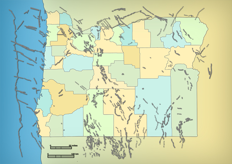
Should the Alquist-Priolo Act be exported to the Pacific Northwest? Many active faults have been mapped in Oregon (Figure 14-1) and Washington. In western Oregon, where most of the people live, only the Portland Hills Fault would be considered for Alquist-Priolo zoning; it is well defined, and it is marked by a linear scarp at the base of the Portland Hills, but without clear evidence of Holocene displacement. LiDAR imagery has revealed surface ruptures in the Puget Sound region that would qualify for Alquist-Priolo zoning, but the Seattle Fault would not qualify because it is not well defined at the surface. Blind faults do not qualify for Alquist-Priolo zoning, even in California. And in southwestern British Columbia, no faults have been mapped that would be zoned under Alquist-Priolo.
The 1994 Northridge and 1989 Loma Prieta earthquakes in California demonstrated that much of the damage was to buildings in areas that underwent liquefaction and landsliding. As noted in Chapter 8, geological and geotechnical studies are able to identify building sites that are vulnerable to earthquake-related ground displacements. To address this hazard, the Seismic Hazard Mapping Act was signed into law in 1990, which requires that not only active faults but earthquake-induced liquefaction and landsliding must be taken into consideration in planning and development decisions.
Maps have been prepared for much of the Los Angeles metropolitan area and for the cities of San Francisco and Oakland, with additional maps being prepared (see the California Geological Survey Web site at http://www.consrv.ca.gov/). The mapping program is supported by building permit fees supplemented by a grant from FEMA and the Office of Emergency Services. Cities and counties must use these maps to regulate development within areas identified as seismic hazards. Building permits must be withheld until the developer shows that the development plan will mitigate the hazard. The law is not retroactive, but if a property within a seismic hazard zone is sold, the seller must disclose that fact to the buyer.
However, the lack of any major urban earthquakes since the 1994 Northridge earthquake has led to a reduction of enforcement standards in the Los Angeles metropolitan area, although starting in 2014, the Mayor of Los Angeles, advised by Lucile Jones of USGS, is committed to stronger enforcement.
Similar maps have been prepared for urban areas in Oregon, Washington, and British Columbia, but their use is advisory only, not mandated by law.
Does this cover all hazards? What about faults or folds that are clearly active but are not well defined according to the Alquist-Priolo Act? For example, geotechnical investigations connected with the planned Los Angeles subway revealed a warp on the south side of the Repetto Hills and Elysian Hills in East Los Angeles called the Coyote Pass Escarpment. This is not a well-defined fault, but it would clearly result in damage if it deformed during an earthquake. This hazard is covered under the Seismic Hazard Mapping Act. Response to faults that are not well defined departs from the Alquist-Priolo strategy of mitigation by avoidance (don’t build on an earthquake fault) to mitigation by design (recognize the zone of deformation, then design structures that will survive surface deformation on it), which is the intent of the Seismic Hazard Mapping Act.
The actions taken by the state of California starting in the early 1970s were groundbreaking, even revolutionary. In no state in the United States and in no country in the world, including Japan, has the government taken such steps to mitigate earthquake hazards. Earthquake programs in all other states lagged behind the establishment of a national earthquake program, and for the most part they have been financed by federal grants. California, on the other hand, preceded the establishment of a national program by more than four years!
The Governor’s Office of Emergency Services (OES) is the state’s counterpart to FEMA, and federal disaster assistance is transmitted through OES. Like FEMA, the agency started out in civil defense in 1950, when the Soviets were ramping up their nuclear weapons program, and Chinese troops were battling Americans in Korea. By 1956, the agency became more involved in natural disaster operations, and the name was changed from the State Office of Civil Defense to the California Disaster Office. The Emergency Services Act was passed in 1970, and the agency’s name was changed to the Governor’s Office of Emergency Services (OES). In 2008, the cabinet-level California Emergency Management Agency and the Office of Homeland Security were combined as part of OES.
The OES coordinates the response of state agencies to major disasters in support of local government. These disasters might be major wildfires, winter storms and floods, tsunamis, or earthquakes. They might be dam breaks, nuclear power plant emergencies, major spills of hazardous materials, and now, terrorist attacks. Communications vans and portable satellite units are available to be sent to disaster areas to ensure communications with remote areas as well as major cities where communications have been knocked out by an earthquake. One hundred and twenty fire engines are available at fire stations in strategic locations. A warning center is staffed twenty-four hours a day, and daily contact is maintained with the National Warning Center and offices of emergency services located in every county.
OES is responsible for the State Emergency Plan, California’s equivalent to the Federal Response Plan. This plan contains the organizational structure of state response to natural and man-made disasters. OES helps local governments and other state agencies in preparing their own emergency preparedness and response plans. A list of publications and videos is provided on the OES Web site at http://www.oes.ca.gov/ The Earthquake Program of OES provides assistance to local and regional governments, businesses, hospitals, schools, human service agencies, community organizations, and individuals in earthquake preparedness. This program has coordinated, through the California Geological Survey, earthquake scenarios on the Cascadia Subduction Zone, the San Jacinto Fault in southeast California, and the Rodgers Creek Fault in the Bay Area, and the Great California ShakeOut response each October 15 to a M 7.8 earthquake on the southern San Andreas fault. The state’s Earthquake Awareness Month is April, the month in which the 1906 San Francisco Earthquake struck.
The Seismic Safety Commission was established by the legislature in 1975 as a state agency to advise the governor, the legislature, and the public on ways to reduce earthquake risk. The commission manages the California Earthquake Hazard Reduction Program and reviews earthquake-related activities funded by the state. Fifteen of the seventeen commissioners are appointed by the governor, and the other two by the senate and assembly. In 1985, the California Earthquake Hazards Reduction Act charged the commission with preparing an Earthquake Loss Reduction Plan, most recently for 2007-2012, to reduce earthquake hazards significantly. The commission proposes earthquake bills to the legislature and will oppose legislation that would weaken the state’s earthquake safety program.
The commission issues reports on earthquake hazard reduction, including reports on building codes. Lists of publications are available at the commission’s web site at http://www.seismic.ca.gov One of these publications is The Homeowner’s Guide to Earthquake Safety. If your house was built before 1960, and you want to sell it, state law requires you to deliver a copy of the Homeowner’s Guide to the buyer.
Humboldt and Del Norte counties are at risk from the Cascadia Subduction Zone, and activities in California have led to a greater resilience to the Cascadia Subduction Zone in California than in regions to the north.
3. Oregon
The Oregon Office of Emergency Management (OEM), a division of the Oregon State Police, is the state counterpart to to FEMA. OEM assists local governments in planning and education, including identification of hazards and technical advice. In addition to coordinating the state tsunami and earthquake programs, OEM manages disaster-recovery activities including public assistance and hazard mitigation grants. Grants were awarded for the retrofit of schools after the 1993 Scotts Mills Earthquake. In 1972, the Oregon Emergency Response System was established by the governor, the first of its kind in the United States. It is managed by OEM as the primary point of contact for state notification of an emergency or disaster. Operations assigned to OEM include the statewide 9-1-1 emergency number, search and rescue, and a state emergency coordination center. This center is activated during a disaster to provide information, direction, and coordination during the disaster, and to provide liaison with the FEMA regional office in Bothell, Washington.
The governing legislation for OEM is ORS 401, which establishes rules for coordination with local government. Each county in Oregon is required to have an emergency operations plan, an emergency operations center, and an emergency program manager. Some counties also have a citizens’ emergency management council, involving the community. Although not required, cities may also have an emergency management program, and three in Oregon do so. There is also an earthquake coordinator for Portland Metro, which includes Portland and satellite cities making up the Portland metropolitan area. The Emergency Coordination Center (ECC) is located at OEM headquarters in Salem and consists of twenty-two state agencies. When a disaster happens, the ECC is the primary contact with the governor and legislature as well as local jurisdictions.
In April 2003, OEM conducted a statewide training exercise called Quakex-2003, a simulated earthquake and tsunami on the Cascadia Subduction Zone. The exercise involved more than one hundred federal, state, county, city, volunteer, and private industry organizations to enable them to test their individual emergency response plans. Those agencies participating were able to test the effectiveness of interagency coordination, cooperation, and communication during a large-scale simulated disaster. The destruction visited on each community was built into the scenario based on realistic assumptions of risk, to see how each agency would respond. Each jurisdiction tested an emergency operations plan, which outlined the roles and responsibilities of agencies and individuals during the emergency.
There were two distinct phases of Quakex-2003. The first phase (response) simulated the first forty-eight hours of the disaster. During this time, public utilities had to respond to repair outages, and local government responded to medical emergencies and threatening situations such as fire, dam failure, building collapses with people inside, flooding, tsunamis, hazardous waste spills, and coastal subsidence. Government began collecting information about the extent of the disaster, dispatching assistance as needed.
The second phase was a recovery phase one week after the disaster, with an emphasis on collecting initial damage assessments from local and state agencies. In a real disaster situation, this assessment would be used to advise the governor about declaring a state disaster area and to provide factual backup for a request to the president to declare a national disaster area, thereby bringing in federal assistance. The assumption was made that Oregon would receive a presidential major disaster declaration, allowing federal and state agencies to work together, processing disaster assistance applications from individuals as well as businesses and local government. After the exercise, there was an after-action report to determine whether the objectives had been met.
OEM responds to a disaster if the city or county fails to act responsibly, if the disaster involves two or more counties, or if a major disaster is imminent or strikes a large area in the state. For Quakex-2003, it was obvious that a disaster would be declared, so everybody participated. The priorities are to save lives and protect public health and safety, provide basic life-support needs, and to protect emergency-response equipment, in that order. Of lower priority is the protection of public and private buildings. In a nutshell: lives first, buildings later.
Several presidential disaster declarations were issued for Oregon during the 1990s: three floods (1990, 1995, 1996), one windstorm (1995), the El Niño and drought of 1994 (which included a salmon-related economic disaster), and the two earthquakes in 1993. In the summer of 2015, disaster declarations have been issued against wildfires during the ongoing drought. Thus OEM is getting plenty of practice in real emergencies, preparing it for a future earthquake much larger than the two that occurred in 1993, including planning for an earthquake on the Cascadia Subduction Zone.
Oregon requires each county to have an emergency management system to respond to a declaration of a state of emergency. Although all would agree that this is an important thing to have, it represents, at least in part, an unfunded mandate. It is an expression of the tendency of legislatures to pass worthy legislation (authorization) without providing the money to carry it out at the local level (appropriation). In 1997, a bill was introduced in Salem to allocate money to create a disaster reserve trust fund, to be administered by OEM, not to exceed $30 million. Money would also be allocated to create and run the emergency management programs of the state and eligible jurisdictions to provide, among other things, statewide uniformity in an operation that requires close coordination for it to work in an emergency. Finally, money would be used as grants, to be awarded competitively to local jurisdictions or nonprofit organizations to implement hazard mitigation projects. Funds for this bill would come from the state lottery, from a tax on insurers against hazards including earthquakes, and from the general fund. With the financial restrictions facing the state legislature in 1997, this bill did not pass, and with the financial crises faced by the 2001 and 2003 legislatures, it is difficult to see how the state will have the resources to deal with the next disaster. It is an idea for the future.
OEM also provides administrative support for the Oregon Seismic Safety Policy Advisory Commission (OSSPAC), established by Governor Neil Goldschmidt by executive order in 1990 after the Loma Prieta Earthquake, then confirmed by Senate Bill 96 in 1991. OSSPAC promotes earthquake awareness and preparedness through education, research, and legislation. OSSPAC includes five representatives from state government, one from local government, six from the public, and six from affected industries and stakeholders. OSSPAC supported several earthquake-related bills and six joint resolutions during the 2001 legislative session. During that session, the legislature passed three earthquake bills and two earthquake joint resolutions. One bill requires state and local agencies and other employers with two hundred fifty or more full-time employees to conduct earthquake drills. The other two bills require seismic safety surveys of schools, hospitals, and fire and police stations. The joint resolutions provide funds for the planning and implementation of seismic rehabilitation of public education and emergency service buildings. However, the legislature provided no funds for the surveys or rehabilitation, but instead sent the joint resolutions as ballot measures to Oregon voters. These ballot measures passed in 2002, authorizing the state to issue general obligation bonds for seismic rehabilitation of public education and emergency service buildings. However, as of September 2003, no funds have been authorized for either the surveys or retrofits, except for a bond issue passed for Portland Public Schools. The Legislature authorized a resilience survey to be supervised by OSSPAC, which presented a grim future when Oregon is struck with the next subduction-zone earthquake. The survey presented a way forward if the State began a major retrofit of unsafe buildings and obsolete bridges, allowing ten years or more to strengthen the State against a major earthquake. A lot could be done in ten years. However, the Legislature failed to appropriate money to begin the project, and also did not pass a major transportation bill that would have addressed the problem of obsolete bridges, a problem the OSSPAC survey had highlighted.
The Oregon Department of Geology and Mineral Industries (DOGAMI) has undergone a dramatic shift in its mission in the past ten years. In earlier years, like the California Geological Survey, it focused on natural resources and the regulation of their extraction, including sand and gravel, groundwater, minerals, and fuels. Geologic hazards were also considered to some extent in reports issued by the agency.
With the recognition of an earthquake hazard in the late 1980s, the legislature in 1989 passed Senate Bill 955, which directed DOGAMI to improve the state’s understanding of earthquakes and other geologic hazards and to use this knowledge to reduce the loss of life and property due to these hazards. DOGAMI’s responsibilities are established by several statutes, starting with ORS 516 with administrative rules, in which the agency is the state repository of information about geologic hazards, including earthquakes. DOGAMI conducts research programs in coordination with the federal government, other state agencies, local government, and universities, usually with federal grants rather than state funding. It is the lead agency in coordinating the issuance of permits for facilities for metal mining and chemical leach mining. It also archives all site-specific seismic reports for critical and essential facilities in Oregon. However, its funds are limited.
DOGAMI has produced earthquake hazard maps of the Portland, Salem, and Eugene metropolitan areas, in which these areas are divided into zones of increasing earthquake hazard based on ground shaking, liquefaction, and potential for landsliding. Plans are underway to construct similar maps for other cities. One use of these maps is to superimpose a building inventory on the earthquake zones, as the State of California and the Portland Bureau of Buildings have done. This highlights the unreinforced masonry buildings that lie in the highest earthquake hazard zone and assists in establishing retrofit priorities. These maps are suitable for the application of the Uniform Building Code to regulate construction on ground subjected to these earthquake hazards.
Senate Bill 379, passed by the Oregon legislature in 1995 and implemented as ORS 455.446 and 455.447, restricts the construction of critical facilities and special-occupancy structures in tsunami flooding zones. In response, George Priest of DOGAMI, in cooperation with scientists outside the agency, constructed tsunami runup maps for the entire Oregon coast. These maps take into consideration the range of sizes of the next earthquake on the Cascadia Subduction Zone as well as a detailed understanding of the configuration of the sea floor, which focuses tsunami waves as they approach the coast. In addition, DOGAMI has done a detailed tsunami study of the Siletz Bay area of Lincoln City and is engaged in detailed studies at Newport and Seaside. A tsunami inundation map of Newport, prepared by DOGAMI, NOAA, and the Oregon Graduate Institute of Science and Technology, is shown as Fig. 9-15a.
Other duties of the agency include serving as the lead technical agency in the Oregon Emergency Response Plan, the installation of strong-motion accelerographs in new buildings, the review of plans for dams and power plants, and participation in the Oregon Seismic Safety Policy Advisory Commission. OSSPAC coordinated an earthquake resilience plan for Oregon, as charged by the legislature.
Assignment of responsibilities to DOGAMI has not always been accompanied by sufficient state funds to do the job. The National Earthquake Hazards Reduction Program, through its focus on the Puget Sound-Portland metropolitan area, provided grants for research in earthquake hazards to DOGAMI, and this was supplemented by individual grants to scientists within DOGAMI and in universities. FEMA and NOAA have also been sources of money. Federal funds made it possible to hire an earthquake geologist, Ian Madin, who served as a highly visible point man for informing the public about earthquake hazards in Oregon. Madin is now DOGAMI Chief Scientist. More recently, the state has allocated funds to DOGAMI to carry out its earthquake-related mission, although, as stated above in another context, appropriation still lags behind authorization.
4. Washington
The Washington counterpart of FEMA and coordinator of the Washington Earthquake Program is the Emergency Management Division (EMD), part of the Washington Military Department. A Seismic Safety Committee, part of the Emergency Management Council, reviews state earthquake strategies, with the most recent update in February 2002, after the Nisqually Earthquake. The EMD collaborates with FEMA in offering courses to the public and private sector on using the HAZUS loss estimation modeling software. EMD also developed an All Hazard Planning Guide for Washington schools. Since the earthquake, the Hazard Mitigation Grant Program provided several grants for seismic retrofit of three water districts, two schools, and a fire department. In addition, the Department of Transportation conducted a retrofit of highway bridges that significantly reduced lifeline losses as a result of the Nisqually Earthquake. As in California, April is Disaster Preparedness Month, with the theme in 2003 “Prepare Because You Care,” featuring a statewide “Drop, Cover, and Hold” earthquake drill with more than a million citizens participating. Washington also participates in the ShakeOut exercise on October 15 of each year.
The Division of Geology and Earth Resources (DGER), part of the Department of Natural Resources, was formed to evaluate mineral resources, like similar agencies in Oregon and California. Like those states, DGER has become more involved in evaluating hazards from earthquakes, landslides, and floods. Steve Palmer of DGER led a program to map urban areas subject to liquefaction and lateral spreading. As described elsewhere, these maps were tested by the Nisqually Earthquake. Palmer and his colleagues Wendy Gerstel and Tim Walsh were able to predict fairly well those areas that underwent liquefaction and lateral spreading in both Seattle and Olympia (Fig. 8-16). Liquefaction susceptibility maps are in preparation for other cities in western Washington. In addition, DGER has a grant from the Hazard Mitigation Grant Program to produce a state map showing liquefaction susceptibility and soil characteristics.
In 1990, Washington passed its Growth Management Act to require comprehensive planning in its most rapidly growing counties and cities. This act required these cities and counties to designate and protect critical areas subject to geological hazards, including landsliding and earthquakes. In 1991, the act was broadened to require the designation of critical areas in all Washington’s cities and counties. The dampening effect this law has had on rapid development around metropolitan areas has led to attempts to amend it in the legislature, and even to repeal it outright.
Unlike California, where the state was proactive in upgrading building codes and grading ordinances, Washington has left much of this to local jurisdictions. For example, there is no state requirement that school districts implement programs to improve the earthquake safety of school buildings. Rural counties and small cities in western Washington, including school districts, have lagged behind the metropolitan centers of Puget Sound, especially Seattle, which has standards that are comparable to those in metropolitan areas of California. Because the Seattle-Olympia area had experienced damaging earthquakes in 1949, 1965, and 2001, school buildings had already been reinforced against earthquakes to a greater extent than in Oregon to the south.
Nearly half of the total damage to Washington schools in the 1949 earthquake was in Seattle; twenty-one schools had to be replaced or repaired. Additional damage to schools was sustained in the 1965 earthquake. Following the 1965 earthquake, the Seattle Public School District began to evaluate its schools for seismic risk, and by 1998, the district was in the final phase of implementing $40 million in capital improvements addressing earthquake hazards. In 1988, the Superintendent of Public Instruction issued a manual, Mitigation of School Earthquake Hazards, that was updated in 1998. Funds from FEMA’s Project Impact were used to remove overhead hazards, especially overhead flush tanks in rest rooms that would pose a danger if they collapsed into a classroom on a lower floor. In addition, funds were used to train maintenance staff to work on nonstructural hazards; these teams are supported by volunteers. At the time of the Nisqually Earthquake, seven schools had been retrofitted by volunteers during Saturday work parties; no injuries or damage was reported at any of these schools during the earthquake.
FEMA designated the city of Seattle as a Project Impact community with an initial grant of $1 million to develop its own earthquake and landslide hazard mitigation program. At the outset, Seattle had 125,000 old houses built prior to requirements that they be bolted to their foundations, with an additional 125,000 houses in King County, outside the city limits. Project Impact has resulted in a program of educating citizens in retrofitting their residences, businesses, and schools and in developing emergency plans. The Seattle Emergency Management office, part of the police department, provides home repair kits, conducts repair workshops, and maintains an approved list of contractors who have the skills to do earthquake retrofits. A special program is in place for businesses. The role of volunteers is critical; the Seattle Disaster Aid and Response Teams (SDART) educate neighborhoods in organizing themselves against a disaster (see Chapter 15). In addition, hazardous areas in the city are being mapped by the USGS and scientists from the University of Washington to identify those areas where special precautions need to be taken in development. Seattle has exported this information to eighteen surrounding cities and counties.
The city of Bellevue is not a Project Impact community, but it has been proactive in earthquake preparedness just as Seattle has. The city’s emergency preparedness division is part of the fire department. Retrofitting of homes is encouraged through speeding up the permit process and helping homeowners obtain low-interest loans for retrofitting. The city has an All Hazards Emergency Plan, responding to severe weather as well as to earthquakes. A project called Strengthening Preparedness Among Neighbors (SPAN) develops emergency plans in neighborhoods, electing team captains and meeting four times a year to review preparedness plans. In alternate years, the city conducts a seven-hour full-scale drill.
DGER and EMD have a tsunami mitigation program for those coastal areas of southwest Washington that are at risk from tsunamis. Inundation maps from a tsunami generated by a subduction-zone earthquake have been prepared. In cooperation with NOAA’s TIME program, tsunami modeling is underway for a tsunami generated by an earthquake on the Seattle Fault, and DGER has published a map with those results. The tsunami potential of the Seattle waterfront has also been evaluated. Maps of Neah Bay, Quileute River, Port Orchard, Port Townsend, and Port Angeles are on the DGER Web page; maps of Bellingham, Anacortes, and Whidbey Island are in preparation. In 2003, the city of Long Beach and the Quinault Nation were recognized as Tsunami Ready and Storm Ready communities. The Quinault Nation was the first Native American nation to receive this award.
5. British Columbia
The Provincial Emergency Program (PEP) is the responsibility of the attorney general of British Columbia. An Earthquake Preparedness Section has been organized within this program; this includes a multidisciplinary Seismic Safety Committee. As of 2003, a resource pool drawn from several Provincial ministries makes up the Temporary Emergency Assignment Management System (TEAMS), which manages the government’s response to any hazard, including earthquakes. PEP has developed curriculum learning resources for elementary and secondary schools.
In November 1996, British Columbia held its third earthquake response exercise in its Thunderbird Series in the Greater Victoria area, responding to an imaginary M 6.9 earthquake fifteen miles from downtown Victoria. The main purpose was to train Provincial response coordinators, with a secondary goal of evaluating a local community college as a coordinating and communications center in the event of an earthquake. More recently, the province conducted a tsunami hazard warning and alerting exercise based on a series of waves affecting the entire B.C. coastline. The exercise was followed by public education and awareness workshops in each coastal community. The adjacent Province of Alberta is collaborating with British Columbia in preparing for an earthquake, recognizing that when the subduction-zone generates an earthquake, Alberta will be part of the response.
The British Columbia Geological Survey has focused on hazard maps of the city of Victoria and of New Westminster and Chilliwack on the mainland. These maps are as detailed as any on the west coast and are suitable for microzonation and land use planning. The Victoria maps may be accessed at www.em.gov.bc.ca/mining/geolsurv/surficial/hazards/default/htm
6. Building Codes
One of the most important steps that can be taken by a community in defending itself against earthquakes is upgrading its building codes. Most codes are written such that a structure built under a seismic code should resist a minor earthquake without damage and resist severe earthquakes without collapse of the building. Building codes place life safety over property damage. They establish minimum standards based on average soil conditions. As discussed in Chapter 8, local ground conditions could generate seismic ground motions that exceed those in the code provisions.
Regulations to reduce property damage and loss of life were in existence in America prior to the American Revolution, when the main concern was the spread of fire in densely populated New York City. Comprehensive building regulations were introduced in the mid-nineteenth century, and in 1905, the National Board of Fire Underwriters published a model building regulation aimed at fire damage. Because of the cover-up of the role of earthquake damage in the 1906 San Francisco Earthquake, nothing was done at that time about extending building regulations to protect against earthquakes.
As structural engineers began to recognize that buildings could be constructed to resist earthquakes, the situation began to change. Following the destructive Santa Barbara Earthquake of 1925, Santa Barbara and Palo Alto passed ordinances upgrading their building codes to take earthquakes into account. But it took the much more destructive Long Beach Earthquake of 1933 to produce statewide action, including an upgrade of building codes. The legislature passed the Field Act upgrading school construction standards and the Riley Act covering other buildings. Earthquake resistance was added to building codes in Los Angeles County and City, Long Beach, Santa Monica, Beverly Hills, and Pasadena, essentially putting an end to the use of unreinforced brick construction in California. Later, earthquake-resistance standards were applied to bridges, hospitals, and dams. Subsequent upgrades to the building codes, generally triggered by large earthquakes such as the 1971 Sylmar, 1989 Loma Prieta, and 1994 Northridge earthquakes, have produced the highest earthquake-resistant building standards in the United States.
The starting point for building codes is the Uniform Building Code (UBC), published by the International Conference of Building Officials with its headquarters in Whittier, California. The UBC was developed following local ordinances in California in the 1920s and 1930s. In the Pacific Northwest, local governments began to base their code upgrades on the UBC, starting with the City of Seattle in 1946. The code established seismic zones in which earthquake reinforcing was recommended, but the Pacific Northwest, except locally, was placed in Seismic Zone 1, requiring no reinforcement against earthquakes.
In 1952, following the 1949 Puget Sound Earthquake, the Puget Sound region was placed in Seismic Zone 3; the rest of Washington and the Portland area were placed in Zone 2. In the following year, Seattle and Tacoma adopted sections of the 1952 UBC, although Tacoma deleted the requirement that houses be bolted to their foundations. Further upgrades in Washington followed the 1965 Seattle Earthquake and the 1971 Sylmar, California, Earthquake. Action at the state level took place in 1974, when Oregon adopted the Structural Specialty Code and adopted the 1973 UBC, placing itself in Zone 2, and in 1975, when Washington adopted the 1973 UBC and established a Building Codes Council. Further upgrades followed the recognition that western Oregon and Washington are at risk from a subduction-zone earthquake, including upgrading most of the urbanized parts of Washington and Oregon into Seismic Zone 3 and placing part of the Oregon coast in Seismic Zone 4. The Washington legislature adopted the latest UBC in 2003.
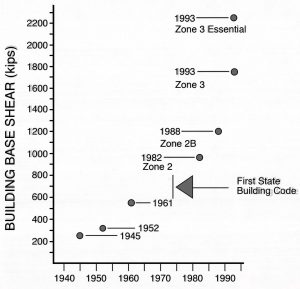
The increase in construction standards is illustrated for Oregon in Figure 14-2; the Washington increase is similar. If your house was built before the mid-1970s, there was no requirement that it be bolted to the foundation; in many areas, this requirement was not enforced until the early 1980s.
The United States now has two model building codes The most widely used is the International Building Code (IBC), developed by the International Code Council, consisting of the three original model code organizations, the Building Officials and Code Administrators International, the Southern Building Code Congress International, and the Council of American Building Officials. The second was developed by the National Fire Protection Association and is called NFPA 5000; it has been adopted by California. The IBC, upgraded every three years, has as its objective “to provide minimum standards to safeguard life or limb, health, property, and public welfare while regulating and controlling design and construction.” Priority is given to protecting the inhabitants of a building over the prevention of damage to the building itself. Building codes represent minimum standards; the owner may well choose to have higher standards than those required by the code.
Two cautions should be made about building codes. The first tradeoff is cost. Upgrading seismic resistance can add up to five percent of the cost of a new building, and for retrofitting, the percentage increase is higher. For a new building, the revised codes set the standard, and the owner must decide whether or not to exceed these standards to get better building performance in an earthquake—a decision similar to whether to obtain earthquake insurance. For a retrofit, the decision is harder, because of the added cost to a business, or the added cost to taxpayers if a public building is retrofitted. Without better insight into earthquake forecasting than is now available, the owner’s decision is a gamble. The estimation of average annual losses due to earthquakes for each county in the United States using HAZUS can be compared with the annual construction cost of upgrading the building code.
The second caution is that upgrading the building code does not automatically make the area safe against earthquakes. New buildings will meet the standard, as will major remodels of buildings. But old buildings that are not remodeled will continue in the building inventory, and when these are unreinforced masonry (URM) or nonductile concrete, they are potential time bombs. The greatest loss of life in the 1971 Sylmar Earthquake was in those buildings on the campus of the Veterans Administration Hospital that had not been retrofitted after the 1933 Long Beach Earthquake (Figure 12-1).
In 1988, California established the URM Law requiring local jurisdictions to inventory their URM buildings, establish loss-reduction programs, and report periodically to the state. As of early 2003, 13,303 buildings have been retrofitted and 3,458 demolished at a cost of $3 billion. Almost nine thousand URM buildings remain in use, but this program is clearly working. Because of these retrofits, the northern California part of the subduction zone is clearly the best prepared for a subduction-zone earthquake.
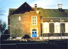
Oregon and Washington have numerous school buildings, city halls, public-housing projects, retirement homes, churches, dams, and bridges that have not been upgraded. The 1993 Scotts Mills (Spring Break) Earthquake caused bricks to fall off Molalla High School that would have caused injury or death to students if school had been in session (Figure 14-3). The Klamath County courthouse was damaged in 1993, and the Grays Harbor courthouse was damaged in the 1999 Satsop Earthquake. The Oregon capitol was damaged in 1993, and the Washington capitol in 2001. However, significant efforts are underway in both states to retrofit schools and bridges. Despite the existence of seismic building codes since the mid-1970s in Washington and Oregon, there are still buildings constructed under earlier building codes that do not meet modern standards and are subject to collapse. It’s important to know the year of construction (or last retrofit) of the building where you work or live so that you can compare it with Figure 14-2.
Following the 1993 seismic upgrade of building codes, the Oregon legislature, through Senate Bill 1057, established a Seismic Rehabilitation Task Force in 1995 to provide recommendations about how to eliminate those structures that are earthquake hazards. At the same time, the City of Portland, through its Bureau of Buildings, established its own task force to consider the seismic strengthening of existing buildings. Senator Peter Courtney strongly advocated for funds to seismically retrofit the State Capital building, but the Legislature failed to authorize the money.
The state task force recommended that all unreinforced masonry (URM) buildings be rehabilitated within seventy years, with the more dangerous within thirty years, following a statewide inventory of buildings by the year 2004 to be conducted by the Building Codes Division. Mandatory strengthening would be required for appendages outside a building such as parapets and signs that could fall on people below during an earthquake. Essential and hazardous URM buildings would be repaired by the year 2019. Essential buildings would include fire and police stations and emergency communications centers. Hazardous facilities would include structures housing hazardous or toxic materials that could be released during an earthquake. A program for rehabilitating hospitals was also proposed.
Other buildings would be rehabilitated based on passive triggers: actions within the control of the owner that would require the building to be strengthened. These triggers would include (1) changes in use that would increase the risk to occupants, (2) renovations that are substantial relative to the value of the building, and (3) renovations or additions that could potentially weaken the existing structure. To encourage and facilitate the strengthening of buildings, a state tax credit was proposed that would be equal to 35 percent of the investment for seismic rehabilitation retroactive to the year western Oregon was upgraded to Seismic Zone 3, and a local property tax abatement equal to 35 percent of the seismic rehabilitation cost were proposed. Implementation of the program would be assigned to the Department of Geology and Mineral Industries (DOGAMI). These recommendations were incorporated into House Bill 2139, introduced in the 1997 legislative session. However, this bill failed to pass. The plan is presented here in the event that a future legislature in Oregon or Washington might adopt it when state finances improve.
Although the state did not act except for critical facilities, the city of Portland is upgrading its URM building inventory through its Dangerous Building Code. Based on an ordinance passed in 1995, two hundred URM buildings have been retrofitted, most due to a change in building use or the installation of a new roof.
An opinion survey was conducted among four hundred Portland residents. When asked to rank earthquakes among several social and environmental concerns, earthquakes were ranked relatively high, behind crime and violence, cancer, motor vehicle accidents, and fire. However, none of the categories was listed as “high risk.” Respondents were also asked to rank on a scale of 1 to 10 (1 = no money should be spent to strengthen the facility, 10 = it is absolutely essential to strengthen the facility) their priority ratings for strengthening key buildings and infrastructure facilities. Hospitals, buildings for storing hazardous wastes, emergency communications buildings, bridges and overpasses, and schools received ratings above 8.
The insurance industry, through its Insurance Services Office, has established a system to grade the 454 building code enforcement departments in California on the effectiveness of their building codes, considering the quality of inspection and plan review as well as construction standards. The results of the grading will appear in an insurance publication called the Public Protection Classification Manual, which is read by more than a hundred thousand insurance agents and actuaries. A high grade should lead to discounts on insurance premiums for new construction, similar to discounts based on fire insurance grading systems.
The problem, as stated elsewhere, is that building retrofits do not necessarily increase the ability of the building to generate additional income, and furthermore, the scientists cannot tell them how soon their buildings will be struck by a major earthquake. Should the building owner bear the total cost of upgrading, or should the cost be borne, at least in part, by local government?
7. Grading Ordinances and Regulation of Building Sites
Building codes deal with the safety of buildings, but how about the site on which the building is constructed? A good example of a poor building site is the Leaning Tower of Pisa. The tower itself is in good shape, but the soils beneath the building are unable to hold it up, and it has settled differentially, causing it to lean.
A perfectly sound building is unsafe if it’s built on a landslide, on a sea cliff subject to wave erosion, on soils subject to liquefaction, or on an active fault. As part of its public safety obligation, a city or county may take responsibility for evaluation of the safety of a building site, just as it takes responsibility for the structural integrity of a building. Ordinances passed for this purpose are called grading ordinances. Grading, which is one of the first steps in virtually any building project, can include excavation by a bulldozer or backhoe or it might involve placement of fill material to provide a flat surface for building. In either case, the natural landscape is altered, and regulation is required to ensure that the alteration of the landscape will not harm residents of other sites—particularly those downhill, in addition to the potential residents or workers in buildings on the site in question.
Grading ordinances call into question the fundamental right of individuals to do with their land whatever they want. This differs from building codes, which might require a better-engineered and better-designed structure to be built for safety reasons but would not prevent some sort of structure from being built on a site. It’s difficult for a landowner to accept the fact that the property might contain hidden geological fatal flaws such as active faults or landslides that could prevent it from being developed at all. A site with a beautiful view over a steep hillslope should not be developed if the steep hillslope providing the view is the scarp of an active fault or a landslide. The site could become unstable because of the actions of the builder or owner, such as heavy use of irrigation sprinklers.
In 1952, the City of Los Angeles adopted the first grading ordinance in the United States and set up a grading section within the Department of Building and Safety. The city was growing out of the lowlands and up into the surrounding hills, and building sites there were found to be subject to major landslides, with extensive property losses.
The grading ordinance was upgraded in 1963 to require both engineering and geologic reports to be submitted, and to require that grading operations be supervised by both a soils engineer and an engineering geologist. Although responsibilities overlap, the soils engineer or geotechnical engineer deals directly with the strength and bearing capacity of earth materials on which a structure is to be built and on the tendency of a hillslope to slide, and an engineering geologist takes more account of the past geologic history of a building site, including old landslides, evidence of faulting, and the inclination of bedding and fracturing of rock formations on site. Geotechnical engineers and geologists must be licensed to practice in all three west coast states.
The standard reference for grading was Chapter 70 of the Uniform Building Code (UBC), written in the form of an ordinance that can be modified to fit the situation in the city or county where it is adopted. In the 1997 edition of the Code, the Grading Code appears in Chapter A-33. In the 2010 edition, soil and grading information is contained in chapters 18and 18a. Other jurisdictions may have different chapters for grading.
The local building official decides which sites pose a potential threat to life and public safety, requiring an evaluation of the site and supervision of grading. For commercial developments, Chapter A-33 provides for reports by both geotechnical and geological consultants employed by the developer and a review of the findings by soils engineers and geologists employed by the city or county for that purpose. The cost of a plan review, like the cost of a building inspection, is borne by the developer in the form of permit fees. A plan reviewer might ask questions such as: Is provision for drainage off the property adequate so that other property owners are not affected? Are cut slopes gentle enough that they would not be expected to fail by landsliding? Is the bearing strength of the soil sufficient to hold up the building? Do potentially active faults cross the property? This last is covered by Chapter 16 of the Code, which also contains sample regulations that cover geotechnical tests for liquefaction and ground shaking.
California passed an addition to its Health and Safety Code requiring that all cities and counties adopt the UBC Grading Code or its equivalent. Unfortunately, many cities and counties lack the professional expertise to regulate grading effectively. In addition, implementation of the Grading Code in some communities has been opposed by developers and building contractors as well as a few politically well-connected landowners. However, where the Grading Code has been used, including review by consultants for the city or county, losses related to geologic conditions have dropped by 90 to 95 percent. The law works!
Accompanying the increase in standards for grading is an increase in the number of lawsuits. If a development is approved, but a landslide subsequently destroys homes on the property, the landowner, the contractor, the engineering and geological firm, the city or county approving the plans, even the bank lending the money for the development may be sued. Were any of the parties negligent in approving the development? As the standards of practice are raised, so, then, are the conditions under which someone could be found negligent.
Oregon and Washington are far behind California in establishing grading ordinances. The ones that exist are largely in the metropolitan areas of Portland and Seattle. Some cities require engineering and geologic reports subject to city review, more do not. This may change after the floods of February and December 1996, when many homes, including some worth hundreds of thousands of dollars, were destroyed by active landslides. According to Scott Burns of Portland State University, the Portland, Oregon, metropolitan area suffered more than seven hundred landslides, resulting in seventeen houses being red-tagged (meaning that they would have to be demolished) and sixty-four houses yellow-tagged (meaning that the occupants could not return until certain repairs had been made). In most cases, these landslides could have been identified by a geologist prior to the development. This led to a flurry of lawsuits, including some against cities and counties. The plaintiff, who may have lost his million-dollar home to a landslide, argues that the city should have known that the site was unsafe, since establishing that fact is standard practice in other parts of the country. Many cities are (or should be) watching these lawsuits with interest and perhaps trepidation.
The Oso landslide in Snohomish County in western Washington on March 22, 2014 was not caused by an earthquake. The area had been studied by a geologist with the USGS who identified the potential for landsliding. Nonetheless, the County did not require geotechnical or geological work to be done on the site prior to construction of homes. The landslide took 43 lives and was widely publicized nationally. Lawsuits resulting from this landslide may force local governments in the Northwest to adopt legally enforceable grading ordinances.
A problem faced in the Northwest is the difference between what can be done—“state of the art”—and what is the standard level of practice in the area. Clearly the standard level of practice is much higher in the Los Angeles and San Francisco metropolitan regions than it is for most of Oregon or Washington, although the “state of the art” is the same in all those areas. For example, it is quite straightforward to evaluate a building site for liquefaction and ground-shaking potential, and Chapter 16 of the Uniform Building Code presents sample ordinances to do this. But it is not standard practice for most of the Pacific Northwest, and it is not carried out, despite the existence of maps of metropolitan Seattle, Portland, Salem, and Victoria that point to areas of potential hazard from liquefaction, ground shaking, and earthquake-induced landsliding, and the success of maps of Olympia and parts of Seattle showing liquefaction and lateral-spread potential in predicting those areas that actually underwent damage in the 2001 Nisqually Earthquake.
Jim Slosson, an engineering-geology consultant and former state geologist of California, is the source of what has come to be called Slosson’s Law, a corollary to Parkinson’s Law: “The quality of professional work will sink to the lowest level that government will accept.” This applies to building codes as well as grading ordinances.
California requires property owners or their agents to disclose to prospective buyers the fact that a property is in a seismic hazard zone or an Alquist-Priolo fault zone. Effective March 1, 1998, an amendment requires disclosure when one of two conditions is met: (1) the seller has actual knowledge that the property is within a seismic hazard zone; or (2) a map that includes the property has been provided to city and county officials by the state geologist, and a notice has been posted at the offices of the county recorder, county assessor, and county planning agency. Disclosure laws are much weaker in Oregon and Washington.
8. Other State Agencies
The California State Department of Insurance licenses and regulates insurance companies and manages a privately financed earthquake insurance plan, the California Earthquake Authority. This plan is discussed in detail in Chapter 10. Caltrans has the responsibility of maintaining the state’s highways and bridges, and it funds research in earthquake engineering, particularly the earthquake resistance of bridges and overpasses. The Washington and Oregon Departments of Transportation have similar responsibilities to Caltrans in maintaining the highway network and in bringing bridges and overpasses up to modern codes.
9. Universities
Until the 1960s, most earthquake research was done at the universities, including the establishment of seismograph networks at the University of Washington, University of California at Berkeley, University of Nevada, and Caltech, in contrast to Canada, where seismography was always a responsibility of the federal government. As noted above, seismographs were considered to be an academic pursuit at the University of Washington until the advent of federal funding for seismographs to monitor nuclear weapons testing. At the present time, networks in the Northwest, Great Basin, and northern California are supported by the federal government, even though they are administered by universities. If an earthquake strikes the Pacific Northwest, the Pacific Northwest Seismograph Network at the University of Washington is called. Both University of Washington and USGS scientists work in the same building, and the distinction between federal and university research is not always clear.
With the recognition of the seismic threat to the Northwest, the University of Washington, Oregon State University, and Portland State University have added faculty with expertise in earthquake geology and earthquake engineering. The University of Oregon and Central Washington University have also developed capabilities in earthquake geology and tectonic geodesy; and geodesists are also at the University of Washington and Oregon State University. As a result, both states have a reservoir of experts able to advise government and the public on earthquake issues, although they do so as private individuals rather than representatives of their respective institutions.
10. Regional Organizations
The Western States Seismic Policy Council (WSSPC) is a partnership of emergency managers and state geoscience organizations working on earthquake hazard mitigation, earthquake preparedness, emergency response, and recovery. It includes all the five western states, British Columbia, Yukon, and Pacific island territories. Federal agencies that are part of WSSPC include the Department of Transportation, FEMA, NOAA, and USGS.
WSSPC is very much involved in training and technology transfer—in getting the message out to the public. It holds an annual conference, collects publications on earthquake matters produced by its member organizations, and helps find money to work on earthquake research. Its web site is www.wsspc.org
Another working group in the Pacific Northwest, including northern California, is the Cascadia Region Earthquake Workgroup (CREW), focused on mitigation against a Cascadia Subduction Zone earthquake. CREW includes representatives from FEMA; state emergency services agencies; the scientific community represented by USGS, universities, and state geological surveys; and private industry. Its executive director, Heidi Kandathil (hkandathil@crew.org), Bob Freitag, is housed at the University of Washington. The involvement of the private sector might be the most important hallmark of CREW. In addition to the expected concerns about loss of life and property, industries in the shadow of the Cascadia Subduction Zone are concerned about loss of market share in the event of a catastrophic earthquake. An example of the loss of market share is provided by the Port of Kobe, Japan, which became inoperable after the 1995 Kobe Earthquake. As a result, other ports in Japan took over the business that had previously gone to Kobe, and the Port of Kobe has yet to regain its pre-earthquake level of business. CREW has a video directed toward businesses in the Northwest. Another group is the Redwood Coast Earthquake Study Group, concentrating on earthquake hazards on the northern California coast.
The Oregon Natural Hazards Workgroup (ONHW) is part of the Community Service Center at the University of Oregon in Eugene, which provides planning, policy, and technical assistance to communities throughout Oregon. Under the leadership of its founding director, André LeDuc, ONHW helps communities develop disaster mitigation programs at both the state and local levels. This includes training and helping communities find additional funding and technical resources to prepare themselves better for disasters, including earthquakes. The role of the ONHW is to link the skills, expertise, and innovation of higher education with the risk-reduction needs of communities and the state, thereby providing service to Oregon and learning opportunities for students. ONHW assisted Clackamas County in preparing its FEMA Disaster Mitigation Plan, the first in the country to be completed under a new law enacted in 2000. ONHW can be contacted at onhw@uoregon.edu, and their website is http://darkwing.uoregon.edu/~onhw. LeDuc is now executive director of Enterprise Risk Services.
A nonprofit corporation called Consortium of Organizations for Strong-Motion Observation Systems (COSMOS) has been formed to encourage improvement in strong-motion measurements and applications, especially in urbanized areas, and to promote the wide dissemination of strong-motion instrument records after an earthquake. The organization is an outgrowth of discussions among the California Strong Motion Instrumentation Program of the California Geological Survey, the USGS, the Bureau of Reclamation, and the Corps of Engineers. COSMOS has its headquarters at the Pacific Earthquake Engineering Research (PEER) center of the University of California Berkeley, located at Richmond. PEER is an NSF-funded research center for earthquake engineering focusing on West Coast problems.
This list of organizations changes over time, and the interested reader should start with the descriptions above and identify the present organizations.
11. A Final Word
The people of California, spurred by disastrous earthquakes in 1933, 1971, 1989, and 1994, have enacted the strongest earthquake laws in the United States, and, indeed, in the world. If a fault is active, you can’t build on it. If an area has a tendency to slide during earthquakes, you’ll have to do a lot of remedial engineering to place a building on it. And if you’re selling a property next to an active fault or within an area with the potential for liquefaction or earthquake-triggered landsliding, you’ll have to tell the buyer about the problem. If you don’t and there’s a damaging earthquake, you can expect a lawsuit.
This is revolutionary land-use legislation. It goes against the so-called inalienable right of a person to do whatever he or she can get away with on his or her own land, because to do otherwise diminishes the value of the land. It states that the value is based not only on a spectacular view but also on hidden flaws that the nonspecialist might not be able to recognize, but are just as apparent to a geologist as a brain tumor is to a cancer specialist. Californians have accepted this infringement on their property rights—albeit grudgingly. California is a pace-setter. If it’s popular in California today, then it’ll be popular everywhere else tomorrow. Is this true for California’s earthquake laws as well?
Oregon has upgraded its building codes close to California standards, but its land-use laws are essentially unchanged. On paper, the seller is required to tell a buyer about geological flaws on the property, but loopholes in the law make this requirement unenforceable. The state has made maps of Portland, Salem, and Eugene showing areas of potential liquefaction and landsliding, but no laws require a developer to abide by these maps. The earthquake problem in Oregon is a federal problem; except for tsunamis, the state has provided no money for earthquake hazard reduction, either from building permit fees or the general fund.
Washington, too, upgraded its building codes, most recently in 2003, and its Growth Management Act provides a way to monitor development on unsafe land. Aside from this act, there is no state regulation of land development, and so this responsibility has been taken up by the cities, most notably Seattle. Its regulation of land development is comparable to that in California, and it has advocated similar controls in other cities, aided by Project Impact funds from FEMA.
Despite these laws, many houses still rest on active faults or are perched atop beach cliffs that someday will slide into the sea, or sit on soft ground that will liquefy during an earthquake. But the life span of many houses is mercifully short, and if we have patience, or luck, these structures will cycle out of the building inventory in a few generations and be replaced by homes that are bolted to their foundations with reinforced cripple walls. If state law is not degraded by future land capitalists, houses built on the Portland Hills Fault won’t be followed by new houses in the same precarious places. So in seventy or eighty years, if present state laws are allowed to remain in place, the old, unsafe buildings will be replaced, which should make for “earthquake-resistant communities,” to borrow a phrase from FEMA’s Project Impact.
The problem is enforcement. The decisions that count are not made at the federal level nor even in state legislatures, which set the standards but do not carry them out. These decisions are made by city councils asked to approve a land development, or planning commissions considering a zoning variance, or building inspectors checking out the welds on steel-frame buildings. Just as the “state of practice” drops precipitously at the California state line, so also does it drop away from the cities around the Bay Area, metropolitan Los Angeles, Seattle, and Portland. Geologists from state agencies have fanned out to explain the new land-use laws to local governing bodies, only to find that many of them have never heard of the planning maps or don’t know how to use them. The decisions that count are too often driven by a well-connected land developer rather than advice from a distant state capitol.
Furthermore, pressure to weaken land-use laws will occur if there is a long period without headline-grabbing earthquakes. The landmark Field Act, upgrading school construction standards after the Long Beach Earthquake of 1933, came under immense pressure after World War II, when the remembrance of collapsed school buildings was overwhelmed by the surging postwar economy. The Seismic Safety Commission and its counterparts in Oregon, Washington, and British Columbia are watchdogs for such legislation at the state level, but what about zoning decisions in a faraway county or city that has yet to experience a disastrous earthquake?
My hope as I write this book is that new laws and building codes are becoming so woven into the fabric of West Coast states that attempts by developers to weaken them will be resisted—not only by scientists, engineers, and planners who are earthquake professionals, but by informed citizens who have the courage to hold their local elected officials to their responsibilities. Earthquakes are an environmental problem just as surely as logging old-growth forests, heap-leach mining in the back country, environmental pollution from nuclear wastes at Hanford, or spoiling a beautiful stretch of coastline or a pristine mountain valley by housing developments. Let’s hope we live up to the challenge.
Suggestions for Further Reading
California Division of Mines and Geology and State Mining and Geology Board. 1997. Guidelines for evaluating and mitigating seismic hazards in California. California Division of Mines and Geology Special Publication 117. 74p.
Cascadia Regional Earthquake Workgroup (CREW). 2003. Business survival kit for earthquakes and other disasters: 27-minute video for small- to medium-size businesses including disaster planning toolkit. Available from Michael Lienau, Global Net Productions, www.globalnetproductions.com or www.crew.org.
Cascadia Regional Earthquake Workgroup, 2013, Cascadia Subduction Zone Earthquakes: A magnitude 9 earthquake scenario, 2013, 23p.
Geschwind, C.-H. 2001. California Earthquakes: Science, Risk, and the Politics of Hazard Mitigation, 1906-1977. Baltimore: Johns Hopkins University Press. The growth of the California earthquake program since the San Francisco Earthquake of 1906.
International Conference of Building Officials, updated every three years. Uniform Building Code in three volumes, available in hard copy or CD-ROM. Whittier, CA: ICBO, Web page www.icbo.org
Mileti, D. S. 1999. Disasters by Design: A Reassessment of Natural Hazards in the United States. Washington D.C.: National Academy Press. 351p.
Oregon Seismic Safety Policy Advisory Commission (OSSPAC), 2013, The Oregon Resilience Plan: Reducing Risk and Improving Recovery for the Next Cascadia Earthquake and Tsunami: http://www.oregon.gov/OMD/OEM/osspac/docs/Oregon_Resilience_Plan_Final.pdf. summary 8 p.
Scullin, C. M. Excavation and grading code administration, inspection, and enforcement. Available through ICBO, Whittier, CA, Web page www.icbo.org
Smith, T. C., and B. McKamey. 2000. Summary of outreach activities for California’s Seismic Hazards Mapping Program 1996–1998. California Division of Mines and Geology Special Publication 121. 38p. and appendices.
Washington State Seismic Safety Committee, Emergency Management Council, 2012, Resilient Washington State, a framework for minimizing loss and improving statewide recovery after an earthquake: Final report and recommendations: Division of Geology and earth Resources, Information Circular 114, 38 p.